Showing 4540 items matching " farm"
-
 Lakes Entrance Historical Society
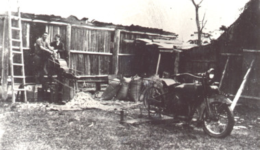
Photograph, Burnes farm 'Collemondah', Kalimna West Victoria, 1925 c
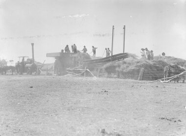
Bags of maize stacked nearby. People thought to be George and Evelyn BurneBlack and white photograph showing man and woman at a machine for husking maize powered by stationary motor bike at Burnes farm Collemondah Kalimna West Victoriaagriculture, genealogy -
 Whitehorse Historical Society Inc.
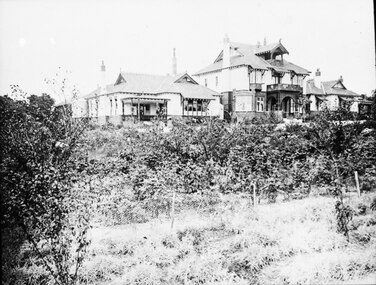
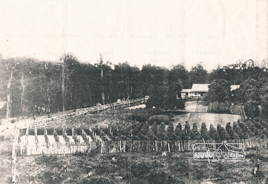
Photograph, Adult Deaf & Dumb Society's Flower Farm
Black and white photograph view of two storey Administrative Block and residents' houses on either side at the Adult Deaf & Dumb Society's Flower Farm at Blackburn Lake.adult deaf & dumb society's flower farm, blackburn lake, flower farm -
 Whitehorse Historical Society Inc.
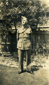
Photograph, Jones Flower Farm, 1940
Jones Family Collection - NP2565 to NP2606. See also ND3831.Black and white photograph of Lionel Jones in army uniform (2/24TH Batt A.I.F.) taken on Jones' Flower Farm in Mt Pleasant Road, Nunawading, in1940.jones, bette, walter, rolf, geoffrey, arthur, keith, lionel, muriel, jones flower farm, mount pleasant road nunawading -
 University of Melbourne, Burnley Campus Archives
Letter (Item), Letter to T.H. Kneen from James Bell re article on the "Scent Farm", Dunolly
-
 Ringwood and District Historical Society
Photograph, Frazer's orchard 'Alkoomi' North Ringwood - Farm house demolition c1971
Harold Frazer’s “Alkoomi” orchard farm house, Oban Rd Nth Ringwood, undergoing demolition after land was sold to A.V. Jennings for housing development. Circa 1971 -
 Whitehorse Historical Society Inc.
Photograph - Black & white photo, Jones Flower Farm, 1936
Jones Family Collection - NP2565 to NP2606. See also ND3831.Black and white photograph of Arthur with daughter Muriel Jones in a horse and buggy, drawn by their pet horse 'Jack',on Jones' Flower Farm in Mt Pleasant Road, Nunawading, in 1936.jones, bette, walter, rolf, geoffrey, arthur, keith, lionel, muriel, jones flower farm, mount pleasant road nunawading -
 Wodonga & District Historical Society Inc
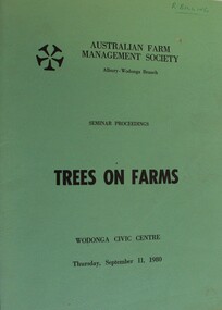
Book - Trees on Farms, Australian Farm Management Society, September 1980
This publication documents the proceedings of a conference held by the Australian Farm Management Societyat Wodonga CIvic Centre on September 11, 1980. It focussed on economic and technical aspects of commercial plantations, agro-forestry and shelter belts on farms. Topics include the Victorian Farm Forestry Loan Scheme, a Farmer's experience in growing and processing pines, and local outlets and future prospects for timber in Australia.non-fictionThis publication documents the proceedings of a conference held by the Australian Farm Management Societyat Wodonga CIvic Centre on September 11, 1980. It focussed on economic and technical aspects of commercial plantations, agro-forestry and shelter belts on farms. Topics include the Victorian Farm Forestry Loan Scheme, a Farmer's experience in growing and processing pines, and local outlets and future prospects for timber in Australia.trees on farms, victorian farm forestry, agroforesty australia -
 Kew Historical Society Inc
Plan - Subdivision Plan, Flower Farm Estate, East Kew, 1922
Pru Sanderson, in her groundbreaking ‘City of Kew Urban Conservation Study : Volume 2 - Development History’ (1988), summarised the periods of urban development and subdivisions of land in Kew. The periods that she identified included 1845-1880, 1880-1893, 1893-1921, 1921-1933, 1933-1943, and Post-War Development. These periods were selected as they represented periods of rapid growth or decline in urban development. An obvious starting point for Sanderson’s groupings involved population growth and the associated economic cycles. These cycles also highlighted urban expansion onto land that was predominantly rural, although in other cases it represented the decline and breakup of large estates. A number of the plans in the Kew Historical Society’s collection can also be found in other collections, such as those of the State Library of Victoria and the Boroondara Library Service. A number are however unique to the collection.The Kew Historical Society collection includes almost 100 subdivision plans pertaining to suburbs of the City of Melbourne. Most of these are of Kew, Kew East or Studley Park, although a smaller number are plans of Camberwell, Deepdene, Balwyn and Hawthorn. It is believed that the majority of the plans were gifted to the Society by persons connected with the real estate firm - J. R. Mathers and McMillan, 136 Cotham Road, Kew. The Plans in the collection are rarely in pristine form, being working plans on which the agent would write notes and record lots sold and the prices of these. The subdivision plans are historically significant examples of the growth of urban Melbourne from the beginning of the 20th Century up until the 1980s. A number of the plans are double-sided and often include a photograph on the reverse. The subdivision called the ‘Flower Farm Estate’ in Kew East occurred in 1922. It included 61 lots on either side of Boorool Road between High Street and Harp Road. In an advertisement in The Argus in the same year, the proximity of the estate to the newly erected shops at the corner of Harp Road and High Street is noted. The Flower Farm Estate and similar subdivisions in Kew East were assisted by the extension of the High Street tramline in 1924.subdivision plans - east kew, flower farm estate, high street - kew east (vic.), boorool road -- kew east (vic.), harp road -- kew east (vic.) -
 Whitehorse Historical Society Inc.
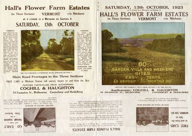
Pamphlet - Advertising brochure, Hall's Flower Farm Estates, 1923
Brochure advertising auction of 'Hall's Flower Farm Estate', Vermont 13 October 1923. 80 sites in three sections, Auctioneers; Coghill & Haughton. Colour and B & W photos.auctions, hall's flower farm estate, short street, vermont, park street, terrara road, canterbury road, view street -
 National Wool Museum
Painting, The White Farm, 2020/21
The farm buildings that Linda Gallus has studied and painted are on the farmland adjoining the Leura Park properties in Curlewis, on the Bellarine Peninsula. The current owner of the property told Linda that he bought the farm in 1994. He has used it for both sheep and cattle grazing since purchasing the property. When the farmer bought the land all the buildings on the property were painted white for sale, despite the fact they were very old. The shearing shed was in use up until the time of sale but was in a bad state of disrepair. The roof, stumps and floor required replacing. The building was no longer in use after the sale, so the shearing shed gradually fell into further disrepair. The previous owner had also used the property for growing potatoes, crops and livestock, mainly sheep. Linda’s fascination with the property came when she caught a glimpse of the white chimney over the hill driving towards Point Lonsdale, which still stands proud today on the roof of the old shearing shed. The owner kindly allowed her to visit the property over the past few years to capture the buildings using photography and painting. During this time many of the buildings have fallen. Linda calls it The White Farm as there are remnants of that original white paint on the outside of most of the buildings giving it a strange and rather beautiful patina. The structures are wonderful remnants of the history of the Bellarine. Linda first spotted the old shearing shed when she was driving home to Clifton Springs from Geelong. It was the white chimney on the shearing shed that stood out behind the rolling grassy hills. It was intriguing – bright white and still in good condition, unlike the rest of the building. After further investigation Linda got to know the owner of the property and visited it frequently to draw, take photos and paint. There is a variety of lovely old buildings on the property, but it was the shearing shed that held extra fascination for Linda. The most intriguing thing for Linda was that the buildings were all painted white at some stage and now the patina of peeling paint and bleached timber brought a wonderful mood and feeling to the farm. This is what she has tried to capture in this series of 11 paintings. Most of the buildings are falling, so Linda felt an urgency to capture them using acrylic paint on canvas in order to commemorate them forever.Acrylic Paint on Canvas. The images both feature a falling down shearing shed as the central focus. The wood of the shearing shed is a central theme of importance. The old buildings were painted white for sale despite being in a state of structural instability. After time this same painted wood has been left with an interesting complex patina like film on the surface which the artist has taken great care to capture. Image 1 is titled ‘Another gust of Wind’. It shows the exterior of the shearing shed which is in the process of collapsing from the forces of mother nature. In the background of this painting another of the buildings in the ‘White Farm’ complex is visible, in addition to blue skies and overgrown green grasses. Image 2 is titled ‘Green Trough’. It features the interior of the same collapsing shearing shed. The image is painted as though the viewer is peering through a crack of the external wall. Internally a green trough is seen hanging on an internal fence. Unlike everything else in the shearing shed, the trough appears new and in good condition. It provides a strong juxtaposition to the rest of the shearing shed, and the larger surrounding ‘White Farm’ complexbellarine peninsula, the white farm, shearing shed -
Whitehorse Historical Society Inc.
Article, Disability farm in limbo, 2013
Doubts have bee raised about the suitability of an alternative site for the NADRASCA farm which is part of the Healesville Freeway Reservation at Morack Road.Doubts have bee raised about the suitability of an alternative site for the NADRASCA farm which is part of the Healesville Freeway Reservation at Morack Road. The site suggested is near Morack Golf Course.Doubts have bee raised about the suitability of an alternative site for the NADRASCA farm which is part of the Healesville Freeway Reservation at Morack Road. nadrasca, healesville freeway reservation, morack road vermont, koedyk, gus, leane, shaun, morack golf course -
 Marysville & District Historical Society
Photograph (Item) - Black and white photograph, 1956
A black and white photograph of the wooden bridge at the Fruit Salad Farm in Marysville that was taken in November 1956.A black and white photograph of the wooden bridge at the Fruit Salad Farm in Marysville that was taken in November 1956.Ken Nita/ at Fruit Salad/ Farm/ Nov 56/ Marysvillemarysville, victoria, australia, fruit salad farm, accommodation, restaurant, photograph -
Federation University Historical Collection
Photograph, Ballarat Demonstration Farm, 24/06/199
ballarat demonstration farm, farm, agriculture -
Ballarat Heritage Services
Photograph, Clare Gervasoni, Brookside Farm Looking Towards the Creek, 21/01/2021
A video of Brookside Homestead looking towards the Creek, taken from the public roadway.brookside, farm, homestead -
 Ballarat Heritage Services
Photograph, Clare Gervasoni, Gates into Brookside Farm, 21/01/2021
A photograph and two videos showing the gates into Brookside Homestead taken from the public roadway.brookside, farm, stable -
 Ringwood and District Historical Society
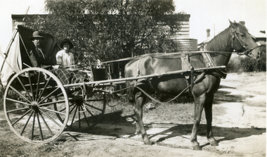
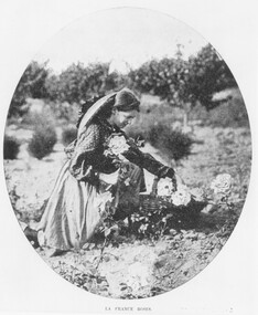
Photograph, Collecting dahlias Hill Bros Flower Farm, Ringwood 1905
Black and white photograph (2 copies)Written under one photograph- "Hill Bros Nursery, Mt Dandenong Rd, 1905. In 1912 sold to Howships. Written on back of one copy, " 'Australian' 29.3.05. John Hill's Flower Farm Mt. Dandenong Rd., later Howship's Flower Farm, subdivided, name retained in street name. Miss Elvie Hill." -
 Ringwood and District Historical Society
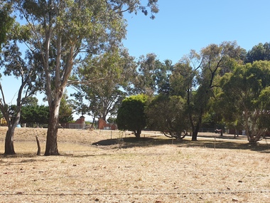
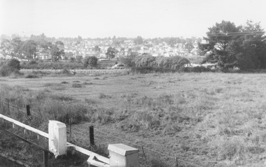
Photograph, View from railway line at Madden Street Ringwood, looking towards New St. Flower farm dam centre - to left. 1960
Typed below photograph, "From railway line at Madden St. looking towards New St. Flower farm dam centre - to left. 1960". -
Whitehorse Historical Society Inc.
Article, It began with a herb farm 117 years ago, 1982
Article about the history of the Slater Family, whose name has been given to Nunawading's latest parkland.Article about the history of the Slater Family, whose name has been given to Nunawading's latest parkland. Robert Slater's Grandfather, William Slater, established what is believed to be the first herb farm in Australia.Article about the history of the Slater Family, whose name has been given to Nunawading's latest parkland. herb farms, parks and reserves, slater, robert, blackburn north, william, william henry, bayley, leonard sherwin, frederick -
 Whitehorse Historical Society Inc.
Document, The Poultry farm at Mitcham, 1/09/1996 12:00:00 AM
Part of an autobiography of Charles OvermanPart of an autobiography of Charles Overman who owned a poultry farm in Vernal avenue, Mitcham from 1928 to 1949. It includes his social activity, chiefly among Catholic friends and his experiences in the industry. 9 pages. Photocopy of typescript.Part of an autobiography of Charles Overman overman, charles;, poultry, vernal avenue, mitcham -
 Eltham District Historical Society Inc
Photograph, Cant house and farm, Salters Rush
Photocopy of image of house and farm of William and Jessie Cant, Salters Rush, Queenstown. The orchard grew cherries, apples, plums, pears, quinces and berries - raspberry, blackberry, gooseberry, red currants and black currants. Also vegetables and flowers. All cultivation done by hand. (Chancellor photograph)houses, farming, orchards, salters rush, queenstown, smiths gully, william cant, jessie cant -
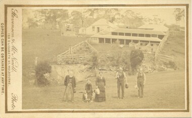 Bacchus Marsh & District Historical Society
Photograph, 'Plainside' Home and Farm of George Dickson Bacchus Marsh 1883
This property was located near Bacchus Marsh not far from the Racecourse. The photo shows members of the Dickson family. The oldest man on the left is possibly George Dickson who died in 1885 aged 92. The man second from the right is possibly the younger George Dickson who died aged 77 in 1900. The girl or the woman in the image is possibly Margaret Dickson.Small sepia unframed photograph on card with gold border framing photograph. Housed in the album, 'Photographs of Bacchus Marsh and District in 1883 by Stevenson and McNicoll'. In the foreground of the image are members of the Dickson family. In the background are yards, farm sheds, which are possibly milking sheds. Behind the sheds is the family home.On the front: Stevenson & McNicoll. Photo. 108 Elizabeth St. Melbourne. COPIES CAN BE OBTAINED AT ANY TIME. On the back: LIGHT & TRUTH inscribed on a banner surmounted by a representation of the rising sun. Copies of this Portrait can be had at any time by sending the Name and Post Office Money Order or Stamps for the amount of order to STEVENSON & McNICOLL LATE BENSON & STEVENSON, Photographers. 108 Elizabeth Street, MELBOURNE. stevenson and mcnicoll 1883 photographs of bacchus marsh and district, dickson family bacchus marsh, farmers, farms bacchus marsh -
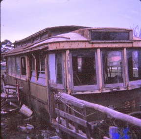 Ballarat Tramway Museum
Slide - 35mm slide/s - set of 2, Graham Jordan, former SEC tram 24 at a farm property, c1973
Yields information about tram 24 following its disposal and how it appeared c1973.Set of 2 Kodachrome white cardboard mount 27mm square slides of former SEC tram 24 at a farm property near Ballarat c1973. Location unknown Advised by Graham Jordan on 21/8/18 by email that the photo was his and that a copy slide was given to John Theodore. Record updated. Various notations by John as to the slide number and the trams in pencil and ink.tramways, trams, tram disposal, scrapped trams, accidents, tram 24 -
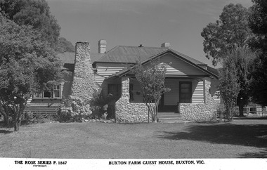 Marysville & District Historical Society
Postcard (Item) - Black and white postcard, Rose Stereograph Company, 1913-1967
A black and white postcard of Buxton Farm Guest House near Marysville. This postcard was produced by Rose Stereograph Company as a souvenir of Marysville.A black and white postcard of Buxton Farm Guest House near Marysville.THE ROSE SERIES P. 1847/ COPYRIGHT BUXTON FARM GUEST HOUSE, MARYSVILLE, VIC.marysville, victoria, australia, buxton farm, buxton farm guest house, rose series, p. 1847, postcard, souvenir, rose stereograph company -
 Eltham District Historical Society Inc
Photograph, Peter Bassett-Smith, Former Brinkkotter Poultry Farm, Main Road, Research, April 1988, 1988
Four colour photographs of the former Brinkkotter Poultry Farm, Main Road, Research depicting the 'Regency Acres' real estate development of 22 lots advertised for auction 19 April 1988. The four photographs are shot by Peter Bassett-Smith in a panoramic sweep of the estate from Eltham College to the Research Primary School.poultry farm, main road, research vic., brinkkotter -
National Wool Museum
Book, Belgenny Farm
"Belgenny Farm" - Department of Planning, Sydney, 1988. History of the buildings of Belgenny Farm, part of the Camden Park Estate which was formerly owned by John and Elizabeth Macarthur.merino sheep - history sheep breeding - history sheep stations - history, macarthur, mr john macarthur, mrs elizabeth, belgenny farm, nsw, camden park estate, merino sheep - history, sheep breeding - history, sheep stations - history -
 Stawell Historical Society Inc
Photograph, Threshing Machine on the farm
Farm Machinery - Threshing machinestawell -
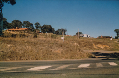
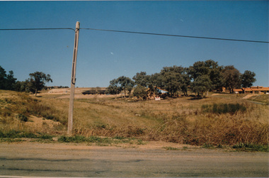
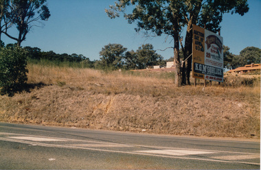
 Eltham District Historical Society Inc
Photograph, Fabbro's farm, Bell Street, Eltham, c.1990s
Fabbro's farm and house, Bell Street, Eltham, c.1990s. A crop of artichokes were planted on the farm at this time. The site of the Fabbro farm (Diamond Creek side land) is now called Barrack Bushlands. It is doubtful that Fabbro's farm holding was ever called Barrak Park, This title is fairly recent after the Shire of Eltham purchased the land, including the last section in 1993/94. About this time the area on the west side of Falkiner Street was purchased by a private developer and developed as housing. The area in Bell Street opposite the Eltham High School was purchased by the State Government is recent years and is called Fabbro Fields. The Fabbro Family operated their farm in Bell Street, Eltham. 1 colour photograph printed with white borderfabbro's farm, bell street, eltham, artichokes, barak farm