Showing 9790 items matching " plenty road"
-
 Greensborough Historical Society
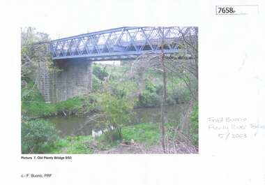
Photograph - Photograph (Copy), Anne Paul, Old Plenty Bridge Lower Plenty, 2003_05
... main road lower plenty...Various views of entry into Lot 2A Main Road Lower Plenty... Main Road Lower Plenty, now Edward Willis Drive, including ...Various views of entry into Lot 2A Main Road Lower Plenty, now Edward Willis Drive, including the old Plenty River Bridge.3 colour photographs printed on paper, handwritten or typed captionslower plenty, main road lower plenty, edward willis drive lower plenty, plenty river bridge, plenty river forum -
 Eltham District Historical Society Inc
Album - Photograph Album, J.A. McDonald, Bridge and Road Reconstruction Works, Shire of Eltham, 1952-1962
... Lower Plenty Road... Bridge Long Gully Creek Long Gully Road Long Gully Lower Plenty ...J.A. McDonald produced this record in the course of his responsibilities as Shire Engineer for Eltham Shire Council.Record of various Shire of Eltham infrastructure works undertaken during the period of 1952-1962 involving bridge and road reconstruction projects, sometimes with Eltham Shire Council Project Reference numbers quoted. It was during this period that a number of significant improvements were made to roads and new bridges constructed within the shire that remain in place as of present day (2022). In many situations, the photos provide a tangible visible record of infrastructure that existed throughout the early days of the Shire. The album was put together by or under the direction of the Shire Engineer, J.A. McDonald.a. gillies, alistair knox park, benchmark studies, bend of islands, blease road, box hill state school, box hill teachers college, box hill tip, bridge construction, bridge street bridge, bridge, brisbane street, brougham steet, bulldozer, cecil street, charis pelling, cherry tree road, city of preston, cr. a. brinkkotter, cr. charis pelling, cranes, cromwell street, diamond creek (creek), diamond street, dixons creek bridge, dixon's creek road, drott, eltham leisure centre, eltham north, eltham police station, eltham, eltham-yarra glen road, f. wood, fitzsimons lane bridge, flat rock road, flood damage, floods, floodwater, footpaths and gutters, ford service garage, g. blair, garden hill, glen park bridge, glenauburn road, grand hotel, haldane road, healesville, healesville-yarra glen road, heidelberg-kinglake road, henley road bridge, henley road, hill property, hurstbridge water scheme, hurstbridge, hurstbridge-arthurs creek road, infrastructure, j. jolly, kangaroo ground, kangaroo ground-queenstown road, kangaroo ground-st andrews road, lilydale shire office, long gully bridge, long gully creek, long gully road, long gully, lower plenty bridge, lower plenty footbridge, lower plenty oval, lower plenty road, lower plenty, main road, methodist church, montmorency, mount pleasant road, new holland, old healesville road, opening ceremony, oxley bridge, para road, paul creek bridge, paul creek road, paul krafeznk, pinnacle lane, plaques, plenty river trail, plenty river, presbyterian church, prof donald thomson, pryor street, railway crossing, railway parade, rattray road, reconstruction works, reichelt avenue, research (vic.), research oval, road construction, rymers corner, shire of eltham, shire of whittlesea, silvan road bridge, silver street bridge, silver street, sir dallas brooks, smedley property, st andrews, steels creek, susan street, tarrawarra, tony carberry, uniting church, upper yarra dam, upper yarra reservoir, w.e. wolf, waterfall property, watsons creek, wattletree road bridge, wattletree road, wattletree road bridge, worlingworth, yarra glen, york street, yow yow creek -
 Eltham District Historical Society Inc
Map (item) - Sales Brochure, Plenty Township Estate and Bryn Teg Hill's Estate, Coghill & Haughton, Melbourne, c.1924
... lower plenty road... hotel houses lower plenty lower plenty bridge lower plenty road ...Plenty Township Estate "The rapid growth of Greensborough and the great traffic development on the main road between Heidelberg and Eltham augurs well for Plenty Township Estate. Already a Store, Post Office and State School have been started, and the activities of the Local Progress Association will help the district forward considerably. Within walking distance of the Montmorency and Greensborough stations." Bryn Teg Hill's Estate "Better known as "The Old Sand Hill, "within walking distance of the Montmorency and Greensborough railways stations." "Some few years back Mrs Thomas subdivided portion of the Sand Hill Paddocks, and the areas sold have been settled and many converted into charming outer suburban garden homes with cultivation and orchard plots. The south-eastern slope gives the land a grand outlook over the Yarra Valley on to the Dandenoings, and the are is very picturesque and homely." "A number of the blocks contain large deposits of valuable building sand, which should prove good speculation in view of the forecast for further rapid home development along the Eltham Suburban Electric Service." Sand Hills Road (Old Eltham Road) Date estimated as c.1924 - Electricification of railway line to Eltham referenced on map occured April 1923 and Mrs Mary Thomas died August 1925. Her home Bryn Teg became part of the Heidelberg Golf Club in 1927.The establishment of Lower Plenty as a suburban growth area supported by easy commuting facilitated by the elctrification of the Eltham railway linebonds road, bridge, bryn teg hill's estate, coghill & haughton, eltham road, heidelberg golf club hotel, houses, lower plenty, lower plenty bridge, lower plenty road, main road, plenty hotel, plenty river, plenty township estate, real estate agent, sales brochure, sand hills road, the old sand hill, sand hill paddocks, woodfull road, old eltham road, bryn teg, mrs m thomas -
 Eltham District Historical Society Inc
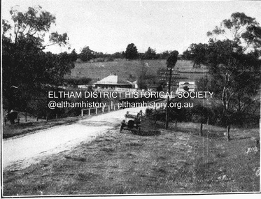
Negative - Photograph, Coghill & Haughton, Old bridge over the Plenty River near Plenty Hotel, c.1924
... Lower-Plenty-Road... hotels Lower-Plenty-Road Plenty-Hotel plenty-river Film - Agfa ...Negative copy and associated print of detail from original Sales Brochure: Plenty Township Estate and Bryn Teg Hill's Estate, Coghill & Haughton, Melbourne (c.1924)Roll of 35mm Black and White negative film, 3 strips, (1 of 14 frames) Print 10 x 15 cmFilm - Agfa Ortho 25bryn teg hill's estate, coghill & haughton, sales brochure, lower plenty, bridge, hotels, lower-plenty-road, plenty-hotel, plenty-river -
 Eltham District Historical Society Inc
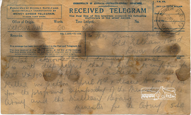
Telegram, Telegram, Victoria Barracks, Melbourne to Mrs Annie Castledine, Old Eltham Road, Lower Plenty, 3 May 1941, 3 May 1941
... Castledine, Old Eltham Road, Lower Plenty, 3 May 1941..., Melbourne to Mrs Annie Castledine, Old Eltham Road, Lower Plenty, 3 ..."Postal acknowledgement delivery personal" "It is with deep regret that I have to inform you that VX10044 Sapper G. E. Castledine has been killed in action April 18th & desire to convey to you the profound sympathy of the Minister for the Army and the Military Board. - Minister for the Army" Sapper George Ernest Castledine (1914-1941), son of Arthur Frederick and Annie Castledine, enlisted 23 January 1940 at Lower Plenty and was assigned to the 2/2 Field Company. He is buried in the Phaleron War Cemetery, Athens, Greece and is remembered on the Roll of Honour at Eltham.George was the first soldier from the Shire of Eltham to be killed in the Second World War. The telegram is oil stained as it was kept by George's brother Sid in his toolbox.Digital image of original held in private collection of Joan Castledine (niece of George Ernest Castledine and daughter of Sid and Polly (nee Arrowsmith) Castledine).Original bears oil stains from being stored in a tool box2/2 field company, aif, annie castledine, arthur frederick castledine, eltham war memorial, george ernest castledine, military, minister for the army, roll of honour, second word war, sid castledine, telegram -
 Eltham District Historical Society Inc
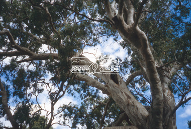
Slide - Photograph, Red Gum, Rosehill Road, Lower Plenty, c.2004
... Red Gum, Rosehill Road, Lower Plenty... District Historical Society meeting significant tree Lower Plenty ...Part of a presentation on "Significant Trees, Wildflowers and Local Gardens" by Russell Yeoman to the 10 November 2004 Eltham District Historical Society meeting35mm colour positive transparency (1 of 36) Mount - white (Pakon)significant tree, lower plenty, red gum, rosehill road -
 Eltham District Historical Society Inc
Slide - Photograph, Red Gum, Rosehill Road, Lower Plenty, c.2004
... Red Gum, Rosehill Road, Lower Plenty... District Historical Society meeting significant tree lower plenty ...Part of a presentation on "Significant Trees, Wildflowers and Local Gardens" by Russell Yeoman to the 10 November 2004 Eltham District Historical Society meeting35mm colour positive transparency (1 of 36) Mount - white (Pakon)significant tree, lower plenty, red gum, rosehill road -
 Eltham District Historical Society Inc
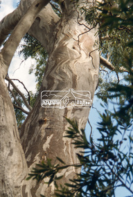
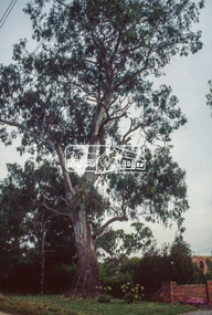
Slide - Photograph, Red Gum, Stawell Road, Lower Plenty, c.2004
... Red Gum, Stawell Road, Lower Plenty... of 36) Mount - white (Pakon) Red Gum, Stawell Road, Lower Plenty ...Part of a presentation on "Significant Trees, Wildflowers and Local Gardens" by Russell Yeoman to the 10 November 2004 Eltham District Historical Society meeting35mm colour positive transparency (1 of 36) Mount - white (Pakon)significant tree, lower plenty, red gum, stawell road -
 Eltham District Historical Society Inc
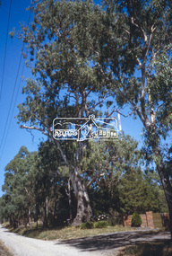
Slide - Photograph, Red Gums, Stawell Road, Lower Plenty, c. 1988
... Red Gums, Stawell Road, Lower Plenty... and White Red Gums, Stawell Road, Lower Plenty Slide Photograph ...35mm colour positive transparency Mount - Black and Whitelower plenty, radio transmission tower, significant trees, stawell road -
 Eltham District Historical Society Inc
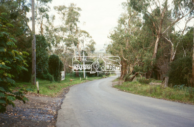
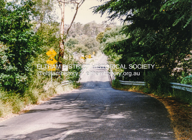
Slide - Photograph, Old Eltham Road, Lower Plenty, c.June 1990
... Old Eltham Road, Lower Plenty... melbourne roads Old Eltham Road Lower Plenty 35mm colour positive ...35mm colour positive transparency (1 of 36) Mount - Agfa CS System grey 8 dotsroads, old eltham road, lower plenty -
 Eltham District Historical Society Inc
Slide - Photograph, Lees Road, Lower Plenty, c.May1990
... Lees Road, Lower Plenty... Ektachrome Lees Road, Lower Plenty Slide Photograph ...35mm colour positive transparency (1 of 25) Mount - Kodak EktachromeProcessing Date Code Jun 90Mroads, lees road, para road -
 Eltham District Historical Society Inc
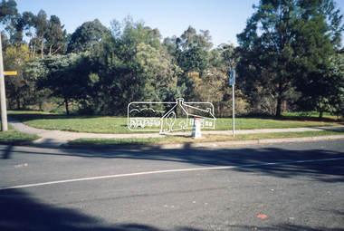
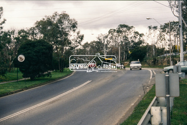
Slide - Photograph, Main Road, Lower Plenty, c.Aug. 1990
... Main Road, Lower Plenty.... infrastructure lower plenty roads Edward Willis Court Main Road 35mm ...Part of a presentation, "Roads and Byways of the Shire of Eltham", by Russell Yeoman to the 12 September 1990 Society meeting. Slides shown included copies of old photos and recent images ranging from the suburban streets of Eltham and Montmorency to the mountain roads of Kinglake. In the byways category are views of some iof the Shire's bicycle paths including then recently completed sections of the Main Yarra Trail at Lower Plenty.35mm colour positive transparency (1 of 37) Mount - Agfachrome Agfa CS System black 8 dotsinfrastructure, lower plenty, roads, edward willis court, main road -
 Eltham District Historical Society Inc
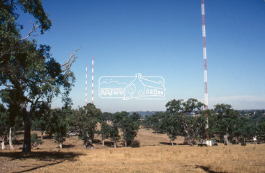
Slide - Photograph, Red Gums, Stawell Road, Lower Plenty, c.Apr. 1993
... Red Gums, Stawell Road, Lower Plenty... melbourne significant tree lower plenty radio transmission tower red ...35mm colour positive transparency (1 of 22) Mount - Kodak EktachromeProcess Date "Apr M"significant tree, lower plenty, radio transmission tower, red gum, stawell road -
 Eltham District Historical Society Inc
Slide - Photograph, Red Gum, Stawell Road, Lower Plenty, c.Apr. 1993
... Red Gum, Stawell Road, Lower Plenty... melbourne significant tree lower plenty radio transmission tower red ...35mm colour positive transparency (1 of 22) Mount - Kodak EktachromeProcess Date "Apr M"significant tree, lower plenty, radio transmission tower, red gum, stawell road -
 Eltham District Historical Society Inc
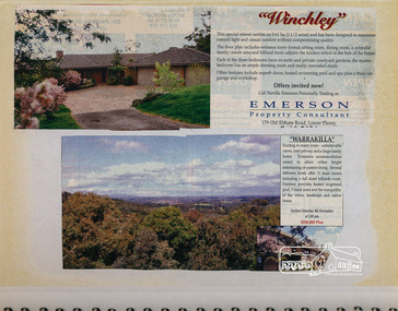
Newsclipping, Winchley, 179 Old Eltham Road, Lower Plenty and Warrakilla
... Winchley, 179 Old Eltham Road, Lower Plenty and Warrakilla... Emerson Real Estate Old Eltham Road Warrakilla Winchley Newspaper ...Contained in Volume 1 of a set of two spiral magnetic photo albums, each containing 10 leaves, 20 pages; Vol. 1 labelled "Houses - Eltham South" and Vol. 2 labelled "Eltham Houses". Newspaper clippings advertising house auctionseltham, eltham south, real estate advertisement, houses, neville emerson real estate, old eltham road, warrakilla, winchley -
 Eltham District Historical Society Inc
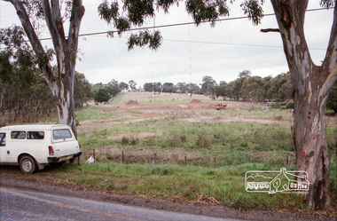
Photograph, Bonds Road, Lower Plenty
... Bonds Road, Lower Plenty...Bonds Road, Lower Plenty, Victoria... melbourne bonds road lower plenty Kodak CL 200 5093 Roll of 35mm ...Roll of 35mm colour negative film, 2 stripsKodak CL 200 5093bonds road, lower plenty -
 Eltham District Historical Society Inc
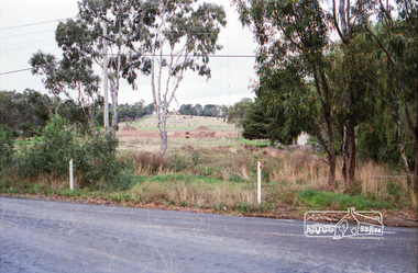
Photograph, Bonds Road, Lower Plenty
... Bonds Road, Lower Plenty...Bonds Road, Lower Plenty, Victoria... melbourne bonds road lower plenty Kodak CL 200 5093 Roll of 35mm ...Roll of 35mm colour negative film, 2 stripsKodak CL 200 5093bonds road, lower plenty -
 Eltham District Historical Society Inc
Photograph, Doug Orford, Bridge, Henty Road, Lower Plenty, 1991, 1991
... Bridge, Henty Road, Lower Plenty, 1991... of Eltham. bridges henty road lower plenty Colour photograph Bridge ...From a collection of 35 photos taken by Doug Orford at 35 specific locations along the exact boundary of the then Shire of Eltham.Colour photographbridges, henty road, lower plenty -
 Eltham District Historical Society Inc
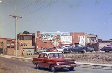
Photograph, Rear view of Lower Plenty shops from Para Road, c.1976, 1976c
... Rear view of Lower Plenty shops from Para Road, c.1976...Para Road, Lower Plenty, Victoria... melbourne Streetscape development over time para road lower plenty ...Streetscape development over timeRoll of 35mm colour negative film, 2 stripsAgfa CNSpara road, lower plenty, shops, shoe inn, maunder's food store -
 Eltham District Historical Society Inc
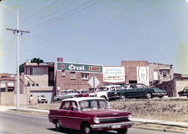
Photograph, Rear view of Lower Plenty shops from Para Road, c.1976, 1976c
... Rear view of Lower Plenty shops from Para Road, c.1976...Para Road, Lower Plenty, Victoria... melbourne Streetscape development over time para road lower plenty ...Streetscape development over timeColour photopgraphpara road, lower plenty, shops -
 Eltham District Historical Society Inc
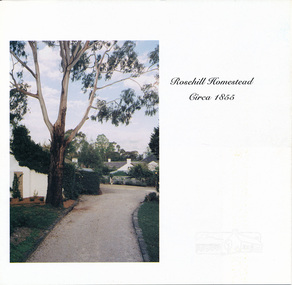
Auction Sale Brochure, Rosehill Homestead, 56 Bonds Road, Lower Plenty
... Rosehill Homestead, 56 Bonds Road, Lower Plenty..., Rosanna houses bonds road lower plenty miles real estate rosehill ...Auction sale brochure, Miles Real Estate Professionals, RosannaBrochurehouses, bonds road, lower plenty, miles real estate, rosehill homestead -
 Eltham District Historical Society Inc
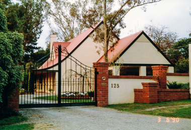
Photograph, Gracedale, 125 Old Eltham Road, Lower Plenty, 3 June 1990, 06/03/1990
... Gracedale, 125 Old Eltham Road, Lower Plenty, 3 June 1990... melbourne lower plenty gracedale old eltham road houses Colour ...Colour photographlower plenty, gracedale, old eltham road, houses -
 Eltham District Historical Society Inc
Photograph, Looking southwest along Alma Street to Para Road, Lower Plenty, c.July 1967, 1967
... Looking southwest along Alma Street to Para Road, Lower... Road, Lower Plenty, c.July 1967 Photograph ...Packaged in "Filmpro King Size prints Definitely Better EST. 1918" envelope. Pencil notes: 36 shots $2.87 Eltham Shire J. McD and 19/7/67. Alma Street and Kett Street Lower Plenty c.July 1967.Black and white photographalma street, lower plenty, houses, streets -
 Eltham District Historical Society Inc
Photograph, Looking northeast along Alma Street to Para Road, Lower Plenty, c.July 1967, 1967
... Looking northeast along Alma Street to Para Road, Lower... Road, Lower Plenty, c.July 1967 Photograph ...Packaged in "Filmpro King Size prints Definitely Better EST. 1918" envelope. Pencil notes: 36 shots $2.87 Eltham Shire J. McD and 19/7/67. Alma Street and Kett Street Lower Plenty c.July 1967.Black and white photographalma street, lower plenty, houses, streets -
 Eltham District Historical Society Inc
Photograph, Looking southwest along Alma Street to Para Road, Lower Plenty, c.July 1967, 1967
... Looking southwest along Alma Street to Para Road, Lower... Road, Lower Plenty, c.July 1967 Photograph ...Packaged in "Filmpro King Size prints Definitely Better EST. 1918" envelope. Pencil notes: 36 shots $2.87 Eltham Shire J. McD and 19/7/67. Alma Street and Kett Street Lower Plenty c.July 1967.Black and white photographalma street, lower plenty, houses, streets -
 Eltham District Historical Society Inc
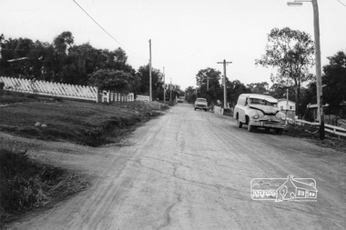
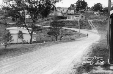
Photograph, Intersection of Kett Street (dirt road) with Airlie Road, Lower Plenty, c. July 1967, 1967
... Intersection of Kett Street (dirt road) with Airlie Road... c.July 1967. lower plenty houses streets Airlie road Kett Street ...Packaged in "Filmpro King Size prints Definitely Better EST. 1918" envelope. Pencil notes: 36 shots $2.87 Eltham Shire J. McD and 19/7/67. Alma Street and Kett Street Lower Plenty c.July 1967.Black and white photographlower plenty, houses, streets, airlie road, kett street -
 Eltham District Historical Society Inc
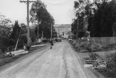
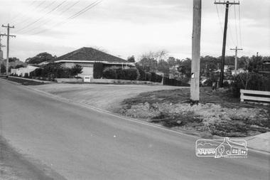
Photograph, Looking south along Kett Street to intersection with Main Road, Lower Plenty, c.July 1967, 1967
... Road, Lower Plenty, c.July 1967... c.July 1967. lower plenty houses streets kett street main road ...Packaged in "Filmpro King Size prints Definitely Better EST. 1918" envelope. Pencil notes: 36 shots $2.87 Eltham Shire J. McD and 19/7/67. Alma Street and Kett Street Lower Plenty c.July 1967.Black and white photographlower plenty, houses, streets, kett street, main road -
 Eltham District Historical Society Inc
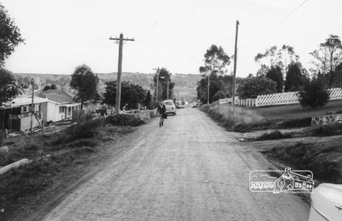
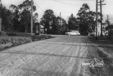
Photograph, Looking north along Kett Street from near the intersection with Main Road, Lower Plenty, c.July 1967, 1967
... with Main Road, Lower Plenty, c.July 1967... c.July 1967. lower plenty houses streets kett street main road ...Packaged in "Filmpro King Size prints Definitely Better EST. 1918" envelope. Pencil notes: 36 shots $2.87 Eltham Shire J. McD and 19/7/67. Alma Street and Kett Street Lower Plenty c.July 1967.Black and white photographlower plenty, houses, streets, kett street, main road