Showing 190 items
matching property values.
-
 Kew Historical Society Inc
Journal - Visitor Book, Fairyland Book
"Fairyland", the home of Jim and Grace Tabulo, was a notable local, state and international tourist attraction situated in Kew, Victoria during the mid twentieth century. Located at 57 Malmsbury Street, Kew, the weatherboard house and its garden were heavily decorated with statues, crockery and other collected items. A series of notebooks were used to record the messages of child and adult visitors to the property from the 1940s to the 1960s. After Mrs Tabulo's death, these visitor books are believed to have formed part of the Dorothy Rogers Collection. They entered the Kew Historical Society's collection following Dorothy Roger's death in 1973.This series of visitor books are the most important primary sources relating to the internationally renowned 'Fairyland' cottage in Malmsbury Street, Kew. Their social significance is that they record in the post war period the values and beliefs of children and adults who visited this historically significant tourist attraction.Foolscap size visitor book containing handwritten comments and drawings primarily made by children during visits to the home of Grace Tabulo, c.1950-1960. Commonly known as "Fairyland", the house was located at 57 Malmsbury Street Kew. The book is wrapped in brown paper, which covers back cardboard covers with a red cloth strip binding. Unpaginated, approximately 160 pages, and covers. The book has an additional loosely inserted black card cover located at the front of the book.Handwritten in pencil on paper cover: "1950 - 1962 /(edit book dates)" Handwritten in ink on paper label on loosely inserted cover: "Fairy Land / Book/ September 1950 / Fairy Land / Book / 75 [sic] M...berry [indistinct] st Kew / Fairy Land Book"grace tabulo -- fairyland -- 57 malmsbury street -- kew (vic.), tourism - kew - 1945-1965, childhood - kew, collectors and collecting, gardens - kew (vic), scrapbooks - 20th century -
 Wodonga & District Historical Society Inc
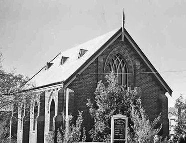
Photograph - First Presbyterian Church, Wodonga
Members of the Presbyterian faith were among the first settlers in the North-east of Victoria, and in the year 1842 the Presbytery of Melbourne requested the Rev. Peter Gunn, Minister of the Gaelic Church, Melbourne, to visit Presbyterians along the Murray River. This was the first of a series of annual visits, and was of a missionary nature. In May 1851, the Rev. David Hunter Ballantyne was appointed to the Wodonga district based out of Albury. In 1860 the Presbytery of Beechworth was formed, and from it two large presbyteries have grown - Wagga Wagga and Beechworth. In the early days the services at Wodonga were held in the old court house, which still stands. Wodonga Presbyterian Church continued as part of the Parish of Albury until the end of 1887, when it was placed under the administration of the Session of the Beechworth Church, with a home missionary in charge. Mr William Cooper was placed in charge for the first months, then Mr William Smith, a city missionary who had recently arrived from Scotland, was appointed. Mr Smith conducted a cordage factory at Stonleigh. He remained as missionary in charge for the next 10 years, and in that time the church steadily progressed. Plans were made for the erection of the building which now stands in High Street, Wodonga. Mr John Whan was a Founding Member of the Church and was appointed Sunday School Superintendent, an office which he held for 46 years, rendering extensive and valued service to the church and congregation. With a growing congregation and realising the challenges presented to the Church by changing conditions, land for a new church was sought. In September 1950 property was purchased in Nilmar Avenue in Wodonga and the new Presbyterian Church St Stephens became their new home. With the amalgamation of the Presbyterian and Methodist Churches, the new Church became the Uniting Church. The original Presbyterian Church was later sold to the Free Serbian Orthodox Church.These photographs are significant because they provide evidence of the changing nature of religious worship and groups in Wodonga.A collection of black and white photographic images depicting the first Presbyterian Church at Wodonga. The Church was later taken over by the Free Serbian Orthodox Church.presbyterian church, free serbian orthodox church, wodonga churches -
 Eltham District Historical Society Inc
Photograph - Digital Photograph, Alan King, Ellis Cottage, Diamond Creek, 23 January 2008
Built by William Ellis in 1865 of local uncut stone about 30cm thick, the cottage is now a museum and home to the Nillumbik Historical Society. Ellis Cottage is historically significant for its association with the Ellis family, who were pioneers of the Diamond Creek district and the benefactors of the notable Nillumbik Cemetery gateway. It illustrates the development of farming in the area. Ellis Cottage is historically and technically significant for its rare use of uncut local stone for building purposes. Covered under Heritage Overlay, Nillumbik Planning Scheme. National Estate Published: Nillumbik Now and Then / Marguerite Marshall 2008; photographs Alan King with Marguerite Marshall.; p79 Ellis Cottage, built by William Ellis, is a memorial to the courage of pioneers in the Diamond Valley area.1 Now a museum and home to the Nillumbik Historical Society, it is a fine example of an early settler’s house in Diamond Creek – and one of the few original buildings standing from the middle of the 19th century. It is a poor man’s cottage – typical of the dwellings of those who had to work hard to wrest a living in this district, because most of the land was not fertile enough for major forms of farming. The pretty stone cottage at 10 Nillumbik Square, built in 1865, is made of local uncut stone about one foot (30 cm) thick. It once stood near the centre of the 147 acres (59.4ha) Ellis bought in 1850. The property extended from Diamond Creek to Reynolds Road and from Perversi Avenue to the Wattle Glen School. It stood in the electoral parish of Nillumbik. The Nillumbik township (later called Diamond Creek) was not created until 1867. In 1912 the property was cut in half by the new railway to Hurstbridge. Ellis paid £147/10/- for the land - about three times what a Victorian farmer would usually earn in a year. Despite the poor quality soil Ellis became a very successful farmer with an orchard, vegetables and a dairy herd. Five years later, in 1855, Ellis bought 70 acres (28.3ha) from neighbour, Hugh Larimour. In 1857 Ellis bought 208 acres (84ha) at Yarra Glen. In 1877 he bought 122 acres (49.3ha) at Diamond Creek and later bought land at Greensborough and Woodstock. Ellis was born in 1815 at Blackawton, a small Devonshire village, and became a tenant farmer. It is not known why Ellis came out to Australia or settled in Diamond Creek. In 1847 he married Margaret Child at the Melbourne Presbyterian Church. Ellis and Child had no children and 18 years after the wedding, while probably living in Kangaroo Ground, Ellis built this small cottage. The simple cottage has a central hall and two rooms on each side. To maximise the small space the ceiling cavity was designed large enough to provide sleeping accommodation accessed via a ladder. Each room was heated by an open fireplace and the one in the kitchen was large enough to roast a sheep. A large cellar under the front room probably stored farm produce. Water came from a well as reticulated water did not arrive at Diamond Creek until 1914. In 1870 Ellis’ 22 year-old nephew Nathaniel joined him from England.2 Until 1890 they developed Ellis Park, praised in The Evelyn Observer, May 30,1890 as a model farm. Ellis had become wealthy, and on his death in 1896 his estate was valued at £9000. In his will he left £100 to construct memorial gates at the Nillumbik Cemetery where he was buried.3 Ellis left the farm to his second wife Louisa. As he had no children, upon her death the farm passed to Nathaniel, but he did not take it up. The farm was sold and leased several times until 1967, when engineer Phillip Lovitt bought the property and carried out major structural works. The Shire of Diamond Valley bought it in the 1980s and in 1989 restored it with the Nillumbik Historical Society. The stone walls of the cottage had been plastered with mud and straw mortar, which were removed as they were riddled with vermin. Doors, windows and a floor were replaced and the original roof of timber shingles had been replaced with slate. The well was too deeply cracked to be restored, so was used for a flower bed. Two mature Italian Cypresses at the entry are also heritage protected as they relate to similar trees planted at Shillinglaw Cottage and other early buildings in Nillumbik Shire.This collection of almost 130 photos about places and people within the Shire of Nillumbik, an urban and rural municipality in Melbourne's north, contributes to an understanding of the history of the Shire. Published in 2008 immediately prior to the Black Saturday bushfires of February 7, 2009, it documents sites that were impacted, and in some cases destroyed by the fires. It includes photographs taken especially for the publication, creating a unique time capsule representing the Shire in the early 21st century. It remains the most recent comprehenesive publication devoted to the Shire's history connecting local residents to the past. nillumbik now and then (marshall-king) collection, ellis cottage, diamond creek, nillumbik historical society, william ellis -
 Warrnambool and District Historical Society Inc.
Administrative record - Rent Ledger, 1910 to 1925
The name of the business that produced the contents of this ledger is unknown. It is a record of rents paid by tenants to the property owners in Warrnambool and district from 1910 to 1925 and includes the rents paid and the dates. It probably belonged to a real estate firm or an accountancy or law firm dealing in property, mortgages and financial investments. Many of the names contained in the ledger are well-known (Coakley, Alston, Gleeson, McGennan etc) and the ones that are not so well known are mostly those with only one or two rental properties. This ledger is of some interest as a research tool giving information on property owners and renters in Warrnambool from 1910 to 1925. It will be of greater value if the name of the ledger owner can be found. This is a ledger with a cover made of wood and covered with a light brown material. It has a heavy metal insert inside to hold the pages. There are heavy card pages and white pages ruled with red and blue lines. The page entries are handwritten in ink. warrnambool renters 1910-1925, warrnambool property owners 1910-1925 -
 Melbourne Tram Museum
Document - Report, Tramway Board, "Valuation etc of Melbourne Tramway & Omnibus Co's freehold properties", c1917
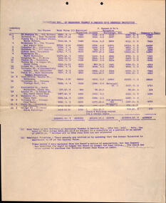
Set of two valuations of the Car Houses or depots owned by MTO Co. titled "Valuation etc of Melbourne Tramway & Omnibus Co's freehold properties". Details the location, book value, municipal valuation, J Buchans & Co land separated for land and buildings and the company claims. One sheet on double foolscap, typed carbon copy and the other on a foolscap sheet with out the company's claim amount. Has a note regarding the company's head office in Bourke St and the Victoria St Feed Works. Two copies held.trams, tramways, mto co, winding houses, depot, cable trams, property, horse trams, head office -
 Melbourne Tram Museum
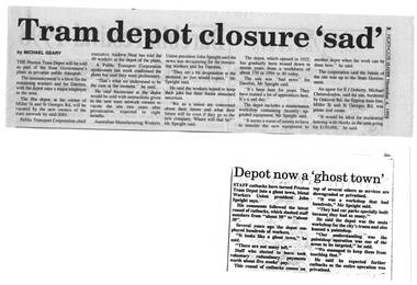
Newspaper, Northcote Leader, "Tram depot closure 'sad' ", "Depot now a 'ghost town' ", 4/11/1998 12:00:00 AM
... about the value of the property. 383.2 - photocopy... Michael Christodoulou of E. J. Doherty about the value ...383.1 - Newspaper clipping from the Northcote Leader, 4/11/1998, titled "Tram depot closure 'sad' ", about the part closure of Preston tramway workshops and the resulting staff redundancies. Quotes Andrew Neal (CEO Public Transport Corporation) and John Speight - Australian Manufacturing Workers Union, AMWU President. Also quotes Michael Christodoulou of E. J. Doherty about the value of the property. 383.2 - photocopy of an article from another newspaper titled "Depot now a 'ghost town' " regarding the part closure of Preston Workshops.trams, tramways, preston workshops, ptc, closure -
 Eltham District Historical Society Inc
Document - Property Binder, 616 Main Road, Eltham; Plum Cottage
Plum Cottage is covered by Heritage Overelay HO256 in the Nillumbuk Planning Scheme This two-lot land holding was created as a subdivision and sold to Charles Stuart McNeil by May 1955. Sometime in the period 1955-1960, the builder-designer, John Harcourt had created a pise house on the site, straddling the two subdivision lots. The designer, John M. Harcourt was a pioneer builder in pise-de-terre and mudbrick in the Eltham Shire, Eltham being synonymous with alternative lifestyles and building practises until the onset of suburbia in the late 20th and early 21st centuries. This hipped-roof house is set high above Main Road on a V-shape plan characteristic of the Arts & Crafts style, with rammed earth or pise walls, timber joinery and a cement tiled roof. The V shape plan was used by important English and Eltham Arts & Crafts designers. The use of natural materials such as stone and timber construction is an essential part of the Arts & Crafts style and Harcourt’s work. So too is the application of the style on both the exterior and interior of the house as a holistic concept. The house adjoins the Lim Joon adobe house built and designed by Alistair Knox in the same era (HO119), thus forming a distinctive pair, both using an uncommon plan form. This house was identified in the Shire of Shire of Eltham Heritage 1992 as contributory to the Eltham Gateway Conservation Area, then proposed as an urban conservation area (now Heritage Overlay Area). Land Ownership Emily Jane Smith of 12 Woodside Street Fitzroy owned Crown Allotments 1 & 2 Sections 14, 27 by August 1918, selling to William Henry Smith of 12 Woodside Street, Nth Fitzroy May 1921. (John) James Isherwood of Main Road, Eltham owned the property by 1928 (the year of his death) with the beneficiary of his estate and next owner of this site being his widow, Minnie Maria Isherwood of Cemetery Road, Eltham. His holding in Main Road included parts of what was described in rate records as allotments1 & 2 Section E6. In the late 1930s, early 1940s her son Alfred John Isherwood was also rated for the land around this site, with the rated nett annual value varying between £2 and £5. Alfred Isherwood also lived at Main Road, Eltham with his wife Ellen: her early death at the age of 24 was reported in the Argus of 1923. Part of the Isherwood land was divided off and sold to Charles Stuart McNeil by May1955. Sometime in the period 1955-1960, the builder-designer, John Harcourt had created a pise house on the site, straddling the two subdivision lots. The house is visible on an aerial photograph from 1960s. Reputedly the house was called Plum Cottage and erected for Harcourt’s mother-in-law. A garage was added in 1959. Charles McNeil died in1971 aged 87: he was the son of Don McNeil and Margaret Arkell. Available rate records from the construction era start in the of the 1970s (1972-3) and list Mr H.C. & M/S A.V. Charity at 616 Main Road Eltham of this property with a nett annual value of $740. More recent valuer's data describes the property as lots 1 & 2 LP25668, located in the Central Riding of Eltham Shire, owned by Ann Valerie Charity and later, in 1990, by the Chincarini family. Building Description This hipped roof 11 .5 square house is set high above Main Road on a characteristic-shape plan and has rammed earth or pise walls, timber joinery and a cement tiled roof. The V-shape plan was used by Important designers such as C.F.A. Voysey (UK) who interpreted medieval domestic architecture as part of the Arts & Crafts style of the late 19th and early 20th centuries. The pise walls are covered with a textured render while the cement roofing tiles are also seen in the Harcourt Hill examples. Reputedly the ceiling joists are of a deep section and span long lengths with no need for hanging beams in the roof space. The ceilings are low and panelled in main rooms with apparently Caneite soft board infill panels between the exposed ceiling beams. These are painted white but may have been stained at one time. The focus of the house is the large living area with its vast random stone fireplace. Significance Plum Cottage is significant to the locality of Eltham because: Historically: • Plum Cottage is closely associated with the important historical theme of earth construction evident in Eltham and elsewhere in the Shire since theear1y Arts & Crafts inspired creations at Penleigh Boyd's The Robins (1912, HO101) and those at Montsalvat (1934-, HO82) but more prominent from the Second War period when earth building in Eltham was promoted in national periodicals as an alternative building method that avoided the building materials shortages of that era; • The choice of the earth building technique also expresses the theme of refuge or alternative living, synonymous with Eltham in the early to mid 20th century; • as a good example of domestic architecture from John Harcourt who was the first major post Second War figure in an important phase of Eltham’s earth building development, using his characteristic Old English or Arts& Crafts style that relies in this case on the pise wall construction, pitched roof forms, exposed ceiling joists, half timbering, random stonework, and panelled internal wall finishes. Architecturally: • Plum Cottage's pise wall construction is uncommon among the early earth-walled structures in the Shire, that are mainly of adobe or mud brick, and as a building material is uncommon among the Shire’s suburban dwellings generally which are clad typically with either fired clay bricks or timber boarding. Aesthetically: • Plum Cottage is a good and well preserved example of a modern Old English or Arts & Crafts style earth-walled building in the Shire • For the proximity of the significant Lim Joon adobe house designed by Alistair Knox adjoining to the north, providing a distinctive earth wall house pair, with uncommon plan forms. Reference Heritage Assessment of Plum Cottage, 616 Main Road, Eltham; Graeme Butler & Associates 2010main road, eltham, property, houses, (john) james isherwood, alfred john isherwood, ann valerie charity, arts and crafts style, charles stuart mcneil, chincarini family, eltham gateway zone, emily jane smith, h.c. charity, heritage assessment, john harcourt, john m. harcourt, lim joon house, main road eltham, minnie maria isherwood, pise construction, plum cottage -
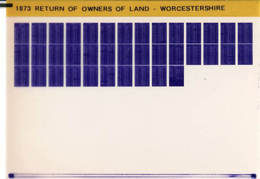 Narre Warren and District Family History Group
Film, West Surrey Family History Society, Return of Owners of Land Worcestershire, England 1873, 1990s
... , detailing the size and estimated rental value of their properties ...The Return of Owners of Land, 1873 for Worcestershire provides a fascinating glimpse into land ownership during the Victorian era. It lists landowners with holdings of one acre or more, detailing the size and estimated rental value of their properties. This survey was part of a broader effort to address concerns about land monopolies and to provide transparency about land distribution. For Worcestershire, the records highlight the disparities in land ownership, with a small number of individuals owning vast estates while many others held smaller plots. The survey also includes information about common lands and waste lands in the county.Set of 1 microfiche non-fictionThe Return of Owners of Land, 1873 for Worcestershire provides a fascinating glimpse into land ownership during the Victorian era. It lists landowners with holdings of one acre or more, detailing the size and estimated rental value of their properties. This survey was part of a broader effort to address concerns about land monopolies and to provide transparency about land distribution. For Worcestershire, the records highlight the disparities in land ownership, with a small number of individuals owning vast estates while many others held smaller plots. The survey also includes information about common lands and waste lands in the county. england -- worcestershire, worcestershire, worcestershire -- land owners -
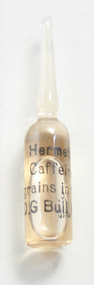 Geoffrey Kaye Museum of Anaesthetic History
Container - Ampoule, Caffeine
Persian physicians Rhazes (860–932CE) and Avicenna (980–1037CE) mentioned coffee in specialised writings, describing its medicinal properties. Although caffeine took centuries to find its way to Europe, it was quickly found to have medicinal value. Coffee has been mentioned in medical journals since the beginning of the eighteenth century, emphasising its capacity for nervous and vasomotor stimulation. Caffeine is a central nervous system stimulant of the methylxanthine class of psychoactive drugs. It is the world's most widely consumed psychoactive drug. Pfizer acquired David G Bull in 1984.Small clear glass ampoule with black printed text on surface containing the amber coloured liquid of 2 grains in 1 cc Hermette Caffeine.caffeine, medical history, medicine, stimulants, stimulant, stimulant drugs -
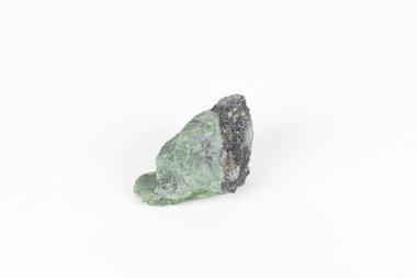 The Beechworth Burke Museum
Geological specimen - Green Feldspar (orthoclase)
Feldspar, derived from the German word feldspat, is a group of minerals which is the most common mineral group found on Earth, making up more than half of the planet's crust. The major rock-forming minerals in the Feldspar group include albite, anorthite, orthoclase and microcline. (Mindat, Feldspar Group). Orthoclase is part of the Feldspar Group subgroup, Alkaline Feldspar, which are known to be poor in calcium, and mostly rich in potassium. It is further also considered to be a K Feldspar, a subgroup of Alkaline Feldspar that are Potassium-dominant with variable crystal symmetry and Al-Si ordering state. Orthoclase are most commonly Colorless to white, Greenish white, Grayish yellow, or Pale pink and transparent to translucent with slightly pearly cleavage. The mineral rates at a 6 on the Mohs Hardness Scale. (cannot be scratched with a knife, but scratches glass with difficulty). The stronger green colour of this particular specimen is distinctive to the Broken Hill region (where it was found), and due to a small amount of lead. (BB) Its qualities find it misidentified at times as as microcline variety amazonite. Broken Hill is one of the world’s richest lead-zinc-silver deposits. The huge, 300-million-tonne orebody was discovered in 1883 and the superb mineral specimens attract collectors from around the world. (Australian Museum, Minerals from Australia: Australian mining regions)While feldspar is not by any means rare, this particular specimen has qualities distinctive to the Broken Hill mining district, with these properties leading at times to the mineral's misidentification. This creates potential for further study and identification of these mineral deposits through methods such as microscopic twinning, or using the position of certain d values in XRD patterns to calculate the degree of disorder of a K-feldspar, as discussed on the Mindat website (Mindat.com, Orthoclase:About Orthoclase). This specimen is part of a larger collection of geological and mineral specimens collected from around Australia (and some parts of the world) and donated to the Burke Museum between 1868-1880. A large percentage of these specimens were collected in Victoria as part of the Geological Survey of Victoria that begun in 1852 (in response to the Gold Rush) to study and map the geology of Victoria. Collecting geological specimens was an important part of mapping and understanding the scientific makeup of the earth. Many of these specimens were sent to research and collecting organisations across Australia, including the Burke Museum, to educate and encourage further study.A solid small aluminosilicate mineral composition which is primarily pale green and blue-grey in colour with traces of beige and white throughout. Note: green plumbian orthoclase (aka green feldspar) is an indicator mineral for the Broken Hill style lead-zinc deposits.N/Abroken hill mine, geological specimen, minerology