Showing 6008 items
matching residential
-
 Lakes Entrance Historical Society
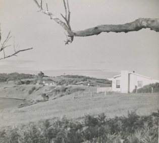
Photograph, Judy Davies, Small blue album of North Arm bridge: Lakes Entrance Victoria, 2010
Small blue album containing twenty eight colour photographs of North Arm from bridge to Cabaritor Point showing new residential sites at Kalimna Victoriaengineering, historic site -
 Lakes Entrance Historical Society
Photograph - " Corumbene" Carpenter Street Lakes Entrance, 1/11/1952 12:00:00 AM
property Corumbene at back of photograph behind tall tree. White house in foreground Basil and Joan Mitchelson's, white house closer to Corumbene home of Jack and Aileen Daniel. Land adjacent to North Arm later subdivided for residential development Lakes . Also another black and white photographs showing property Corumbene later subdivided fronted by Carpenter Street today. Plus 2 coloured photos of a house being moved from Coates Rd to O'Neils Rd Lakes Entrance 1989 Black and white photograph of the property Corumbene at back of photograph behind tall tree c1952. White house in foreground Basil and Joan Mitchelson's, white house closer to Corumbene home of Jack and Aileen Daniel. Land adjacent to North Arm later subdivided for residential development Lakes Entrance Victoria. Also another black and white photographs showing property Corumbene later subdivided fronted by Carpenter Street today. Plus 2 coloured photos of a house being moved from Coates Rd to O'Neils Rd Lakes Entrance 1989land development, houses -
Federation University Historical Collection
Booklet, Ballarat School of Mines Planning Paper, 1977, 1977
Ballarat School of Mines is a predecessor institution of Federation University Australia.Two planning papers for the School of Mines and Industries, Ballarat. .1) Planning Paper 1977/4, June 1977 by Graham H. Beanland, Principal. Includes developmental planning, educational philosophy, campus and accomodation, residential accomodation needs. .2) Planning Paper 1977/5, August1977 by Graham H. Beanland, Principal. Includes developmental planning, educational philosophy, campus and accomodation, residential accomodation needs.ballarat school of mines, smb campus, tafe, planning paper, graham beanland, campus plan, ballarat school of mines campus -
 Ringwood and District Historical Society
Poster, Land Sale Advertisement - Pinemont Estate, Ringwood, Victoria - circa 1924
Map of residential allotments for sale, with terms of sale, summary of subdivision features and local services and facilities, and photographs of local street scene and lake (Loughnan's Lake - location not marked), Subdivision includes Wonga Road (later Loughnan's Road), Glenvale Road, Kubba Road, Felix Crescent, Summit Crescent, Pine Crescent, Aurum Crescent, Hygeia Parade, Panorama Avenue, Avalon Grove, Montalbo Road, Cielterre Avenue. Sole Agents T.M. Burke Pty Ltd, 340 Collins Street Melbourne Phones 6294, 6779. Map by S. Callanan, Licensed Surveyor, 107 Elizabeth Street Melbourne. Date of poster estimated from railway services information extract " ... 36 fast electric trains to Flinders Street daily ... proposed electrification to Croydon ..." . Timeline for electrification of Lilydale Line record indicates Box Hill to Ringwood January 1923, Ringwood to Croydon November 1924 (Source: History of Croydon - McGivern, Vol.1 p20). -
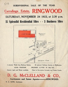 Ringwood and District Historical Society
Flyer, Subdivisional Auction Sale Brochure, Carralinga Estate, Ringwood, Vic. - 1923
Double sided folded page with black and red print on both sides advertising auction sale of residential and business sites and highlighting local facilities, services and layout of the estateSubdivision includes Ringwood Street, Bourke Street and Bond Street. (Agent) D.G. McClelland & Co., Auctioneers and Estate Agents. Phone 37. R.G. Gunn, Auctioneer. -
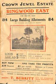 Ringwood and District Historical Society
Flyer, Subdivisional Land Sale Brochure, Crown Jewel Estate, Ringwood East, Vic. - c.1925
In May 1884, George Smart of Bulleen Road Kew, brickmaker, bought the 23 acres one rood and twenty nine and three tenths perches, or 9.4834 hctares from Arthur Bailey Clements of Ringwood for the sum of 600 pound sterling. (Extract from The Story of the Crown Jewel Estate in Ringwood East pdf)Double sided folded page with black and red print on both sides advertising auction sale of residential and business sites and highlighting local facilities, services and layout of the estate.Subdivision includes Mount Dandenong Road, Valda Avenue, Evon Avenue, Mirabel Avenue, and Velma Grove. (Agent) T. Burkitt, Box 12 Ringwood, Phone Ringwood 157. Vendor: A. Marshall Miller, McDonald Street, Mordialloc. Solicitors: Russell, Bona and Russell, 19 Queen Street Melbourne, and Ringwood - Phone Cent. 4308. -
Federation University Historical Collection
Booklet - Report, Proposals for the Development of The Lydiard Street Site of the School of Mines and Industries, Ballarat, 1974, 20/11/1974
The report includes an organisational diagram, general aims, facilities, estimated floor areas.Twenty eight page typed report of proposals for the Development of the SMB campus, and a proposed title for the College "Ballarat Regional College". There is also a page on the advantages of student residential accommodation.smb campus, campus plans, ballarat regional college, ballarat school of mines lydiard street, gardens, library, student accomodation -
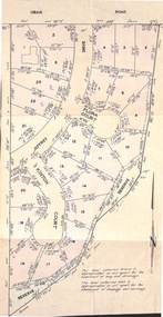 Ringwood and District Historical Society
Document - Folder, Kinton Court Estate Subdivision, Ringwood, Victoria - 1975
Manilla folder containing plan of residential subdivision, with price list and summary of services available. Subdivision includes Oban Road, Jeffrey Drive, Flora Court and Kinton Court. Timbered land - 22 sewered allotments. Agents - C.E. Carter & Son RESI., 122 Whitehorse Road, Ringwood (Phone) 8706211. -
 Bendigo Historical Society Inc.
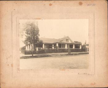
Photograph - LARGE EDWARDIAN STYLE HOUSE ON CORNER BLOCK
Black and white photograph on embossed card. Large Edwardian? Style house on corner block. Gable roof with attic in front. Bay windows under return verandah with concrete rendered supports, decorative brick work on balustrade. Picket fence with lattice on top. Pergolas over gates. Inscriptions on front - 'Vincent Kelly, Bendigo'. On back - 'Knights/front view', TC Watts & Son, Auctioneer, Estate Agents, Imperial Fire Office. Beehive Chambers, Pall Mall, Bendigo' (rectangular decorative stamp on back). 'Royal Historical Society of Victoria, Bendigo Branch (circular stamp).buildings, residential -
 Bendigo Historical Society Inc.
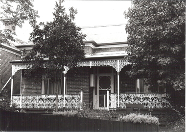
Photograph - BRICK HOUSE
BHS Collectionblack and white photo: brick house, with iron lace verandah, iron roof, low paling front fence. Reverse of photo:; 2, 12, Ward, FSP, 1204, ?, Bunknownbuildings, residential -
 Bendigo Historical Society Inc.
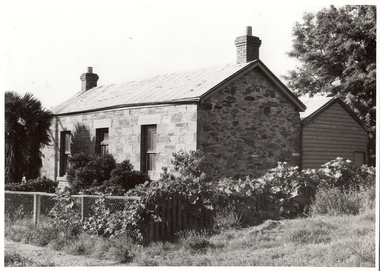
Photograph - STONE HOUSE, Late 1960s
House, Stone, weatherboard addition at back, corrugated iron roof, cyclone wire fence, 2 brick chimneys with terracotta pots, palm tree at left, creeper growing on fence. Central door, 1 window each side of doorAlan Doneybuilding, residential -
 Bendigo Historical Society Inc.
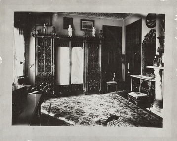
Photograph - FORTUNA COLLECTION: GEORGE LANSELL'S BEDROOM, FORTUNA VILLA, c1900
Black and white photograph of George Lansell's bedroom at Fortuna villa. History of object: George Lansell 'The Quartz King', Fortuna Villa, Chum Street, Bendigo. Ornate furnishings of a bedroom of period showing half of room. Ornate wardrobe and mirror on marble topped table next to marble fireplace. W Ninnisplace, residential -
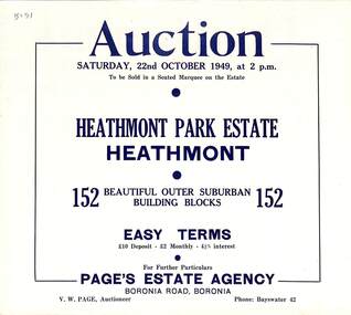 Ringwood and District Historical Society
Flyer, Land Auction Sale Brochure, Heathmont Park Estate, Heathmont, Vic. - 1949
Double sided multi-fold advertisement for auction sale of residential allotments, including summary of subdivision features and local facilities. Auction on Saturday, 22nd October, 1949, at 2 p.m.Subdivision includes Great Ryrie Street, Erica Crescent, Neil Street, Frances Street, Viviani Crescent, and Canterbury Road. Agent - Page's Estate Agency, Boronia Road, Boronia. Phone Bayswater 42. -
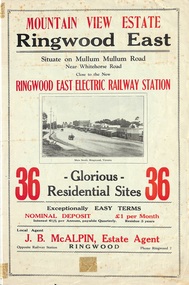 Ringwood and District Historical Society
Flyer, Land Sale Brochure, Mountain View Estate, Ringwood East, Vic. - 1923
Bi-fold advertisement for sale of residential allotments, including photographs, map, and summary of subdivision features and local facilities. Undated handwritten notation reads "streets don't exist today".Subdivision layout includes Mullum Mullum Road, Rangeview Avenue, Press Avenue, and Mountview Avenue. Local Agent - J.B. McAlpin, Opposite Railway Station, Ringwood, Phone Ringwood 7. Vendor - T.J. Press, Builder, "Monterey", Second Avenue, Kew, Telephone Haw. 3428. -
Whitehorse Historical Society Inc.
Newspaper - Article, Church buys crown land, 20 May 1992
Article from Nunawading Gazette 20 May 1992 re the purchase of land adjoining Nunawading Residential Youth Centre at a cost of $1 million by Seventh Day Adventist Church.seventh day adventist church, nunawading, nunawading, churches, winlaton -
University of Melbourne, Burnley Campus Archives
Newspaper - Newspaper Cutting, The Argus, An Interesting Experiment, 1934
Article in "The Argus" January 27, 1934 about former Burnley graduate, Joan Anderson (1924), starting a residential horticultural training school for girls. To be known as "Hermitage Nursery Garden."the argus, female students, joan anderson, nursery, hermitage nursery garden -
Glenelg Shire Council Cultural Collection
Award - Trophy - Best Kept Rural Residential Garden Glenelg Shire, c. 2002
Medium Density Fibreboard Trophy, dark blue marbled finish. Banner shaped brass plaques top and bottom.Top - 'Best Kept Rural Residential Garden in the Glenelg Shire' - engraved' Bottom - 'Donated by Francis plants' - engraved. Small brass plaques with winners names. -
Port Melbourne Historical & Preservation Society
Plan - Area bounded by Nott Street, Graham Street, Esplanade West and Rouse Street, Port Melbourne, 29 Feb 1952
Plan showing properties in area bounded by Nott, Graham, Esplanade W. and Rouse Streets with plan showing properties in area bounded by Station, Graham, Nott and Rouse Streets (House Common Orders) Also statistics of 1948.Top RH corner - reverse: notation - 'residential zoning amendment':Face: continuing notations (at least up to 1963):Lower, indication : 'Existing conditions 1948'built environment - commercial, built environment - civic, built environment - domestic, built environment - industrial, town planning, religion - roman catholic church (st josephs), swallow & ariell ltd, troedel & cooper pty ltd, wilsons sheet metals, franklin & anderson, g h westwood & sons, atlas plastics, w j carr, craven, robert timms, sunkist, tip top paints, knox schlapp pty ltd, daro plastics, triton construct, newmans, national bank, religion - wesleyan methodist church, court house, police station -
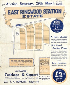 Ringwood and District Historical Society
Flyer, Land Sale Auction Brochure, East Ringwood Station Estate - 1924
Bi-folded double sided sheet with yellow and blue print advertising auction of retail and residential allotments on Saturday, 29 March (1924), including details of subdivision features and local facilities. Subdivision includes Station Street, Wenwood Street, Lois Street, Victoria Street. Auctioneer - Tudehope & Coppard, 229 Collins Street, Melbourne, Tel. Central 2409, in conjunction with local agent, T.A. Burkeitt, Ringwood, Tel. Ringwood 157. -
Glenelg Shire Council Cultural Collection
Photograph - Photograph - Aerial photograph of an area of Portland, Victoria, 1955
Port of Portland CollectionA black and white aerial photograph taken from the N.W. of T.B.& S. abattoir, red brick wool store, petroleum installations, north/central Portland residential areas and Portland Harbour.Front: NOV 1955 'AIRSPY PHOTO' ref NO 2/b/74port of portland -
Glenelg Shire Council Cultural Collection
Photograph - Photograph - N.W., of T.B.& S. abattoir; red brick wool store; petroleum installations; north/central Portland residential areas and Portland Harbour, 1955
Port of Portland CollectionFront: NOV 1955 'AIRSPY PHOTO' ref NO 2/b/74port of portland archives, portland harbour, portland residential areas, tb and s abattoir, red brick wool store, petroleum installations -
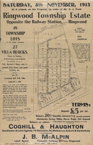 Ringwood and District Historical Society
Flyer, Auction Sale Advertisements - Ringwood Township Estate, Ringwood, Victoria - 1913
Advertisements for auction sale of retail and residential blocks opposite the Ringwood Railway Station on Saturday, 8th November, 1913, showing subdivision layout, terms of sale, and summary of local features and services. Auction at 3 o'clock on the property by order of Mr. O.J. Pratt - 18 township lots, 27 villa blocks, also weatherboard butcher's shop with 5-roomed weatherboard house and good stabling, and 5-roomed new weatherboard villa. Subdivision includes Station Road (later Warrandyte Road), Pratt Street, and Whitehorse Road. Agents - Coghill & Haughton, 79 Swanston Street, Melbourne, Auburn & Canterbury, in conjunction with J.B. McAlpin, Opposite Railway Station, Ringwood. -
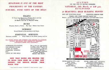 Ringwood and District Historical Society
Flyer, Land Auction Advertisement adjoining Jubilee Park, Ringwood, Victoria - 1956
Folded double-sided brochure advertising residential land sale auction on Saturday 24th March (1956), with locality map and subdivision layout, terms of sale, and summary of local features and services. Subdivision includes Reilly Street Ringwood, and Philip Street, Daisy Street, and Lorienne Street Heathmont. Surveyors - Messrs Little and Brosnan. Agents in Conjunction - Peter Martin Pty. Ltd., Estate Agents, 55-57 Latrobe Street, Melbourne (Phone) FB 3571, FB 2783, and Peter Aubin Pty. Ltd. R.E.S.I., Auctioneers & Estate Agents, 345 Lonsdale Street, Dandenong (Phone) Dandenong 340, After Hours, Dandenong 932, 70. -
Port Melbourne Historical & Preservation Society
Document - City of Port Melbourne, Application for firewood, 1940s - 1950s
Application for firewood by pensioners. City of Port Melbourne. Requires residential details, length of residence, number of people at residence (and their employment status) other than pensioner. Used approximately 1940s and 50slocal government - city of port melbourne, john may -
 Ringwood and District Historical Society
Document - Plan of Subdivision, Part of Crown Allotment 31B, Parish of Warrandyte - 1965
Map showing residential allotments numbered 1, 2, 4 and 5, on Through Road, Ringwood, Vic., with property dimensions, including weatherboard house and galvanised iron garage on lot 2.Kirkpatrick & Webber, Licensed Surveyors, Civil Engineers & Town Planners, Maroondah Highway, Ringwood, Telephone 8700321. Ref 3438C. Date 4th December, 1964. Amended 19th July, 1965. Notation: "The land coloured blue is a drainage and sewerage easement. Levels are to Board of Works Datum. Lot number 3 has been omitted." -
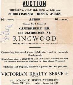 Ringwood and District Historical Society
Flyer - Land Auction Sale, Ten Acres, Maidstone Street Ringwood - 1958
Double sided page advertising Auction, Thursday, July 17th, 1958, (Approx.) 10 Acres, north corner of Canterbury Road and Maidstone Street, Ringwood. Agents - Victorian Realty Service Pty.Ltd., 360 Lonsdale Street, Melbourne, Phone MU7858, After Hours JA1045. Reverse side shows map of proposed subdivision by K.J. Noonan & Co., Surveyors & Engineers, 495 St.Kilda Rd, Melbourne, marked subject to approval of all interested statutory authorities.Residential zoned subdivision land for immediate development. Extensive frontage to Maidstone Street. Accompanying handwritten annotation "10 acres offered as a whole, later re-subdivided". -
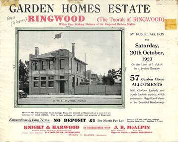 Ringwood and District Historical Society
Flyer, Subdivisional Land Auction Sale Brochure, Garden Homes Estate, Ringwood, Vic. - 1923
Double sided multi-folded page advertising auction sale of residential allotments highlighting local facilities, services and layout of the estate. Includes panoramic view of Ringwood and other local photographic images.Subdivision includes Mullum Mullum Road, The Centreway, Wattle Crescent and Reserve Crescent. Agents - Knight & Harwood, 315 Collins Street, Melbourne, Phone 10615, 10616 Central, in conjunction with J.B. McAlpin, Opposite Railway Station, Ringwood. Phone Ringwood 7. -
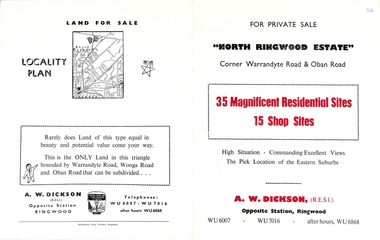 Ringwood and District Historical Society
Flyer, Land Sale Brochure, North Ringwood Estate, Ringwood, Vic. - 1958
Double-sided land sale advertisement for sale of 35 residential and 15 shop sites on the corner of Warrandyte Road and Oban Road, Ringwood North, Vic., including locality plan and features of the estate.Subdivision includes Oban Road, Warrandyte Road, and Dickson Crescent. Agent: A.W. Dickson, Opposite Station, Ringwood. (Phone) WU6007, WU7016, after hours WU6868. -
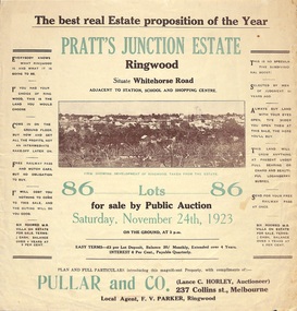 Ringwood and District Historical Society
Flyer, Brochure for Land Sale By Public Auction, Pratt's Junction Estate, Ringwood, Victoria - 1923
Folded double-sided brochure advertising 86 residential lots for sale by Public Auction at 3pm, Saturday, November 24th, 1923, with town photographs, map of subdivision and summary of local features and services. Subdivision plan includes Whitehorse Road, Oliver Street, Georges Road, Junction Street, and six room weatherboard villa for sale. Local Agent - F.V. Parker, Ringwood. -
 Ringwood and District Historical Society
Flyer, Land Sale Advertisement - East Ringwood Township Estates, East Ringwood, Victoria - circa 1920
The date of the flyer as circa 1920 can be estimated from the references to the (decision on) "electrification of the Croydon Railway Line" which eventually occurred in 1923, letting of tenders for the state school building which opened in 1924, and the "proposed new railway station" (East Ringwood) which opened in 1925, Advertisement for three retail and residential allotment land sales in East Ringwood Township including maps showing layout of subdivisions. Township Estate, State School Estate, and East Ringwood Station Estate.Subdivision plans include Mount Dandenong Road, Grey Street, Eastfield Road, King Street, Everard Road, Holland Road, Purser Avenue, and Charles Street. (Agents) Spencer Jackson, Subdivider & Homebuilder, 341 Collins Street, Melbourne, Phones: M2327 (3 lines), also at Dromana, Phone 65.