Showing 40723 items
matching roads and streets
-
 Canterbury History Group
Photograph - Street view from Maling Road of the Canterbury Post Office at No. 206 Canterbury Road, Canterbury, Stuart Warmington, 1995
Coloured photograph of street view from Maling Road of the Canterbury Post Office at No. 206 Canterbury Road, Canterburycanterbury, maling road, shops, edwar, edwardian architectural design -
 Eltham District Historical Society Inc
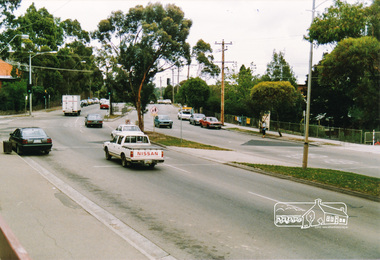
Photograph, Main Road, Eltham near Dudley Street
Three colour photographs of Main Road, Eltham at Dudley Streetmain road, dudley street, eltham -
Port Melbourne Historical & Preservation Society
Legal record - Contract, construction of Williamstown Short Road, Port Melbourne, 13 Nov 1896
Contract for the construction of Williamstown Short Road and part of Graham Streetengineering - roads streets lanes and footpaths, rumpt bros & ebeling, town of port melbourne, town of williamstown -
 Ballarat Heritage Services
Photograph - Digital photograph, Lisa Gervasoni, Traffic Lights Obscured in Cotham Road, Kew, 2017, 2017
Colour photograph of the corner of Cotham Road and Charles Street in Kew. kew, cotham road, charles street, intersection, traffic lights, citipower, vicroads, boroondara council, safety, poor location -
 Bendigo Historical Society Inc.
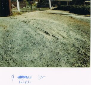
Photograph - CASTLEMAINE GAS COMPANY COLLECTION: PHOTO LILAC STREET
9 Lilac Street - Date Unknown - Gravel road and GateKodakbendigo, streetscape, lilac street -
Canterbury History Group
Photograph - Street view of shop at No. 138 Maling Road, Jan Pigot, 27/03/1993 12:00:00 AM
Coloured photograph of the street view of shop at No. 139 Maling Road.canterbury, maling road, shops -
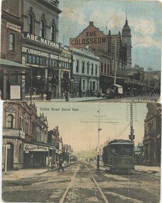 Emerald Museum & Nobelius Heritage Park
Postcard - Postcard Set of Inner Melbourne Streets, c. 1900s
These postcards are part of an album of postcards which date from late 19th century to mid 20th century.This postcard is in an album of postcards dating from the late 19th century to mid 20th century and, as such, indicate the popularity of collecting postcards in Australia which reached a height in the early 1900s until around 1920.Postcards of Chapel Street, Prahan and Union Road, Ascot Valepostcard, 1900s -
 Kew Historical Society Inc
Plan - Subdivision Plan, Normanby Estate, East Kew, 1913
Pru Sanderson, in her groundbreaking ‘City of Kew Urban Conservation Study : Volume 2 - Development History’ (1988), summarised the periods of urban development and subdivisions of land in Kew. The periods that she identified included 1845-1880, 1880-1893, 1893-1921, 1921-1933, 1933-1943, and Post-War Development. These periods were selected as they represented periods of rapid growth or decline in urban development. An obvious starting point for Sanderson’s groupings involved population growth and the associated economic cycles. These cycles also highlighted urban expansion onto land that was predominantly rural, although in other cases it represented the decline and breakup of large estates. A number of the plans in the Kew Historical Society’s collection can also be found in other collections, such as those of the State Library of Victoria and the Boroondara Library Service. A number are however unique to the collection.The Kew Historical Society collection includes almost 100 subdivision plans pertaining to suburbs of the City of Melbourne. Most of these are of Kew, Kew East or Studley Park, although a smaller number are plans of Camberwell, Deepdene, Balwyn and Hawthorn. It is believed that the majority of the plans were gifted to the Society by persons connected with the real estate firm - J. R. Mathers and McMillan, 136 Cotham Road, Kew. The Plans in the collection are rarely in pristine form, being working plans on which the agent would write notes and record lots sold and the prices of these. The subdivision plans are historically significant examples of the growth of urban Melbourne from the beginning of the 20th Century up until the 1980s. A number of the plans are double-sided and often include a photograph on the reverse. The Normanby Estate, which was adjacent to Normanby Road, Kew East, included thirty-one lots for sale. Streets on the subdivision plan include Adeney Avenue, Park Hill Road, Normanby Road, Weir Street and Wharton Street. Cotham Road and its tramway are shown nearby. The plan is interesting as it shows Wharton Street, named after the architect and town planner George Wharton, who was the first chairman of the Municipality of Kew. The street was to later be renamed Cecil Street. Also shown are proposed ‘Municipal Gardens’ where Parkhill Drive is now located.subdivision plans - kew, normanby estate -
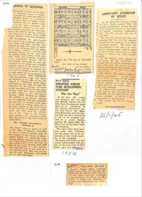 Ringwood and District Historical Society
Newspaper, Newspaper articles detailing the acquisition of 40 acres of land for Jubilee Park, formerly known as Sanders Estate, for recreation purposes
Various newspaper articles about detals of the acquisition, by Ringwood Council, of 40 acres of land for Jubilee Park, formerly known as Sanders Estate, for recreation purposes in 1945-1959. The area included named streets - Prussia Road (not West Prussia Road), Duffy Street, Ireland Street, Evens Street and Chapman Street. -
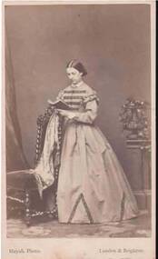 Bendigo Historical Society Inc.
Photograph - PORTRAIT OF A LADY
Small full length portrait of a lady standing beside a chair reading a book which is resting on the back of the chair. She is wearing a long high neck dress with frills at the sleeve tops and dark bands across the bodice. The dark material is also repeated at the hem in a V shape. Photographer's name and address printed on the front and back.Mayall, 224 Regent Street, London. 90 King's Road, Brightonphotograph, portrait, female, portrait of a lady, mayall -
 Kilmore Historical Society
Photograph, Sydney Street Kilmore, 1880's
2.5x1.5 inch black and white photograph of 1 Powlett street, the Court House Hotel, former colonial bank of Australasia. Corner of Powlett Street and Lancefield Road. Copy printed on card stock. Two story light coloured rendered building. The intersection of Lancefield Road, Powlett Street, Sydney Street and (modern day) Skehan Place. With a view straight down Sydney Street. One figure crossing the road.Writing on the back: PHO-00004hotels, historical towns -
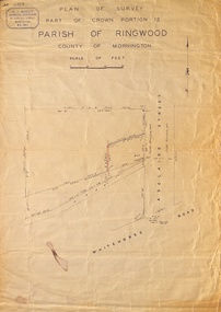 Ringwood and District Historical Society
Map, Plan of Survey, Part of CP12, Adelaide Street, Ringwood, Circa 1920s
Undated map of part of commercial area in Parish of Ringwood, County of Mornington showing Adelaide Street, Whitehorse Road, and un-named laneway behind Whitehorse Road shops marked as Road, and New Road Alignment. Made by H.J. Macey, Licensed Surveyor 36 Narissa Street Burwood BX1917. -
Port Melbourne Historical & Preservation Society
Document - Specification, Williamstown Road, Derham Street to Raglan Street, Port Melbourne, 14 Mar 1893
Written specification of works attached to plan of Williamstown Road from Derham Street to Raglan Street. (67.1) 1893.A.V. Heath (Town Surveyor). J.J. Bartlett (Mayor).engineering - roads streets lanes and footpaths, arthur victor heath, town clerks, james john bartlett, mayors -
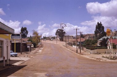 Stawell Historical Society Inc
Slide, Ian McCann, Upper Main Street from Partick Street
upper Main Street, from Patrick Street looking towards Big Hill, before road being resealedstawell buildings -
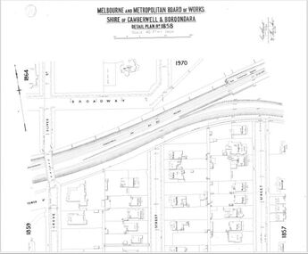 Camberwell Historical Society
Map (Item) - MMBW map, Melbourne and Metropolitan Board of Works, Melbourne and Metropolitan Board of Works - Shire of Boroondara and Camberwell - Detail Plan no. 1858, August 1904
Lithographer E.H.H., Exd J.W.D, Aug 1904, No. 103. 40P.15W.melbourne and metropolitan board of works, map, camberwell, cartography -
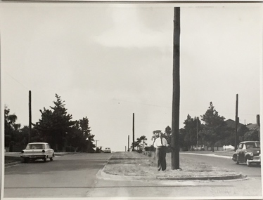
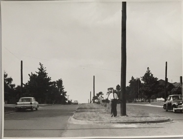 Kew Historical Society Inc
Photograph, Stuart Tompkins Studio, Electricity Supply Poles, Burke Road, Kew, 1965
Research provided by Stuart Tompkins Studio, Box Hill, into alternatives for median strip street lighting to be used in Burke Road, Kew. The photographers identified variants in different suburbs appropriate to Kew's needs.The series from which the photograph is drawn provides a snapshot by a commercial photographic studio of each named vicinity in 1965 as well as providing examples of public works infrastructure being commissioned by local government in the 1960s. The photos originally formed part of the Engineering Department's files in the City of Kew before being donated to the kew Historical Society.Electricity Supply Poles, Burke Road, Kew, 1965. This photograph of Burke Road, Kew was taken just north of Kilby and Doncaster Roads looking north. Stuart Tompkins Studio provided the photograph for the Kew City Council. In the photograph are a number of electricity supply poles that have been erected in the median strip, in addition to some new poles on each footpath. The nearest wooden pole is stated to be 13.5″ in diameter. The electricity poles in Burke Road required Kew Council to investigate comparable designs in other Melbourne municipalities. [There are three copies of this photograph in the Collection.] Typed inscription on reverse: "Electricity Supply Poles. Photographed for Kew City Council 8/2/65. No.5 Burke Road - Kew, just north of Kilby and Doncaster Roads looking north. Some of seven poles already erected in median strip. Shows also some new poles erected on each footpath. Nearest wooden pole 13 1/2" dia." Studio stamp: "Stuart Tompkins Studio. 547 Station Street, Box Hill. WX1439."stuart tompkins studio, street lighting, south road (moorabin) 1965 -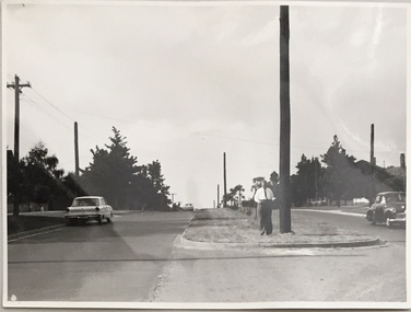
Whitehorse Historical Society Inc.
Article, Traders seething at trial road closure, 2004
Mitcham traders are opposed to the closure of the service road entrance from Whitehorse Road to McDowall Street for a three month trial.Mitcham traders are opposed to the closure of the service road entrance from Whitehorse Road to McDowall Street for a three month trial.Mitcham traders are opposed to the closure of the service road entrance from Whitehorse Road to McDowall Street for a three month trial.whitehorse road, mitcham, mcdowall street, mitcham, roads and streets -
Canterbury History Group
Document - Balwyn Road Canterbury, c1990
Handwritten notes about early Balwyn Road between Canterbury Road and Erica Street, supplied by Eileen Fisher [1900?]canterbury, balwyn road, erica street, canterbury road, fisher> eileen -
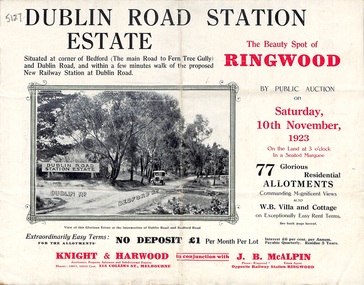 Ringwood and District Historical Society
Pamphlet, Land Sale Brochure, Dublin Road Station Estate - 1923
"Extracts from Recent Daily Newspaper - Ringwood Train Service - STATION WANTED AT RINGWOOD EAST. A deputation from the Ringwood East Railway League and Progress Association waited on the chairman of the Railway Commissioners yesterday afternoon and asked that a railway station be erected at Dublin-road, a mile and a quarter from Ringwood. The deputation urged that there were 81 passengers who, if the station were provided, would make daily use of it, and that as the Commissioners had purchased a site for a station at Dublin-road it was evident they had at one time considered it the most suitable site. The Chairman of Commissioners stated that the estimated cost of the station was £3700. Land owners in the locality should pay a proportion of the cost. Members of the deputation replied that there would be no difficulty in raising the money."Multi-fold brochure advertising public auction of residential allotments on Saturday, 10th November, 1923. Brochure includes subdivision features, local facilities and photographic images of the area and details of proposed new railway station at Dublin Road.Subdivision plan includes Dublin Road, Alexandra Road, Vonadawn Avenue, Green Street, Howard Avenue, Wood Street, and Bedford Road (Main Ferntree Gully Road). Auctioneer - Knight & Harwood, 315 Collins Street, Melbourne, Phones Central 10615, 10616. Agent - J.B. McAlpin, Opposite Railway Station, Ringwood, Phone Ringwood 7. -
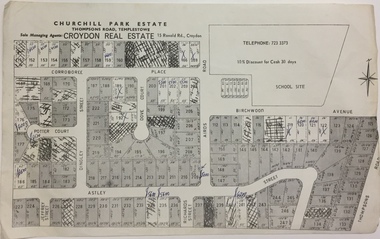 Kew Historical Society Inc
Plan - Subdivision Plan, Churchill Park Estate, Templestowe
Historic subdivision plan of the Churchill Park Estate in Templestowe.Undated subdivision plan advertising the Churchill Park Estate inTemplestowe. Streets identified in the plan include: Corroboree Place, Astley Street, Jeffrey Street, Airds Road, Dove Court, Potter Court, Thompsons Road, Richards Street, and Birchwood Avenue. This record includes a copy of the price list.Annotations in ink on the plan by agentsubdivision plans - templestowe (vic), churchill park estate - templestowe (vic) -
 Ringwood and District Historical Society
Flyer, Land Sale Advertisement - Sunbeam Estate, East Ringwood, Victoria - circa 1930
Folded double-sided page advertising private sale of 48 residential allotments, with location map, terms of sale, and details of local features and services. Locality plan includes Holland Road, Everard Road, Sunbeam Avenue, Mount Dandenong Road, and Lilydale Road (later Old Lilydale Road). (Agents) Phillips & Nicholson, 59 Swanston Street, Melbourne, (Phone) Central 10907, in conjunction with C.E. Carter, Bank Chambers, Main Street, Ringwood, Telephone Ringwood 24. -
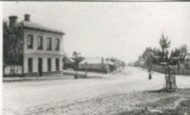
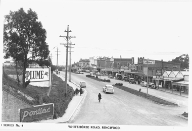 Ringwood and District Historical Society
Photograph, Maroondah Highway Central, Ringwood. Whitehorse Road looking west from Warrandyte Road. c1930's
Black and white photograph (2 copies)Inscribed on photograph: "Series No 4. Whitehorse Road, Ringwood. Image shows shops on north side of road from Warrandyte Road railway bridge to Ringwood Street. -
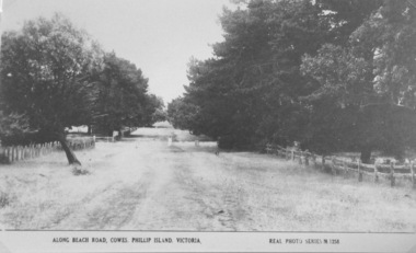 Phillip Island and District Historical Society Inc.
Photograph, Unmade road in Cowes
Part of a collection of 'Rose & Valentine' series of Post Cards. Copied by John Jansson 1984View of a beach road, Cowes. Unmade, grassy, tree lined street.Along Beach Road, Cowes, Phillip Island, Victoria. Real Photo Series M1256local history, photography, photographs, postcards, cowes, phillip island, black & white postcard copy, phillip island early roads -
 Eltham District Historical Society Inc
Photograph, Main Road, Eltham at Dalton Street
Colour photo of Main Road, Eltham looking south at Dalton Streetmain road, dalton street, eltham -
 Ringwood and District Historical Society
Photograph, Bedford Rd / Bayswater Rd. looking east from Warrandyte Rd. railway underpass, c1910
Dirt Road with houses and planter boxes for street trees on one side.Multiple copies of photos SS0078 and SS0079 - Backing sheet on one reads "Bedford Rd. looking east from Warrandyte Rd. railway underpass, c1910". Others have Bayswater Rd, Bedford Rd etc names. Some copies state "Ringwood House on Right". There is a also a postcard version. SS0079rev is an image of the postcard reverse, dated feb 24 1910 -
 Whitehorse Historical Society Inc.
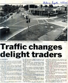
Article, Traffic changes delight traders, 1996
Installation of traffic lights on the corner of Railway Road and Chapel Street in Blackburn.Installation of traffic lights on the corner of Railway Road and Chapel Street in Blackburn.Installation of traffic lights on the corner of Railway Road and Chapel Street in Blackburn.blackburn chamber of commerce, railway road, blackburn, chapel street -
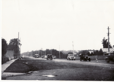 Whitehorse Historical Society Inc.
Photograph - B/W Photograph, Chapel Street and Whitehorse Road Blackburn C 1936, C1936
Black and white photo of Corner Whitehorse Road and Chapel Street, Blackburnchapel street, blackburn -
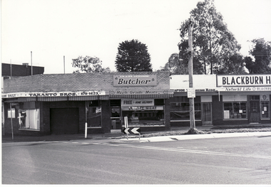 Whitehorse Historical Society Inc.
Photograph, Corner Chapel Street and Railway Road, Blackburn
Black and white photo of corner Chapel Street and Railway Road, Blackburnblackburn road, blackburn