Showing 233 items matching " ruins"
-
 Magnet Galleries Melbourne Inc
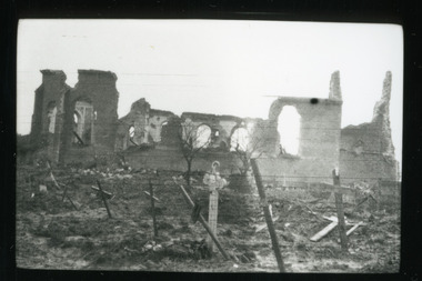
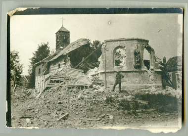
graves amongst ruins, les chandler_red cliffs018.tif
On the Western Front.photowestern front, ruins, graves, grave, cemetery, ww1, world war 1 -
 Bendigo Historical Society Inc.
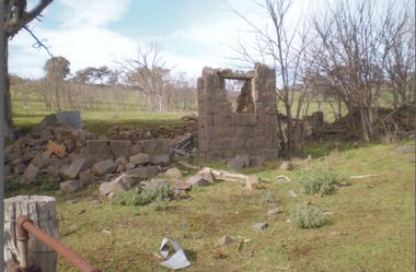
Photograph - BENDIGO HISTORICAL SOCIETY COLLECTION: RUINS OF MIA MIA HOTEL
Colour photograph of bluestone ruins of former Mia Mia Hotel, Mia Mia. Part of one wall standing with window opening. Bare trees in background and on side. Burke and Wills Expedition travelled through this region and allegedly visited the Mia Mia Hotel. The Burke and Wills expedition passed through Mia Mia in 1860 on their journey across Australia from Melbourne to the Gulf of Carpentaria. They arrived on Saturday, 25 August 1860 and made Camp VI at Mia Mia.buildings, commercial, mia mia hotel -
 Bendigo Historical Society Inc.
Photograph - NATIONAL TRUST COLLECTION: PHOTOGRAPH ALBUM
Photograph album, plastic and vinyl. Contains sixty coloured photographs of a National Trust tour of Heathcote and district. 7th and 8th November, 1998. Organized for the photographic committee by McIvor Historical Society. Photos include: Redesdale Presbyterian Church, Coliban Estate, Redesdale Hotel, Redesdale Bridge, Mia Mia Uniting Church, Spring Plains, Heathcote Hospital, Heathcote Powder Magazine, Moorabbee Ruins and grave C. Patterson, Derrinal, Mt Camel Homestead, Open Cut at Heathcote, Heathcote Church.national trust, properties, historic homesteads -
 Sunbury Family History and Heritage Society Inc.
Photograph, The Old Mill Road at Sunbury
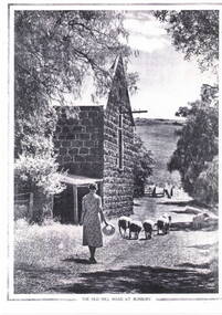
John Eadie, a miller from Perthshire in Scotland, established a water-driven flour mill on the banks of the Jacksons Creek downstream from the Macedon Street crossing in 1861. He also built a weir and water-race to ensure there was plenty of water to drive the mill. The mill produced flour until the early years of the twentieth century. In 1914 the large shell and the iron roofing were removed to aid the war effort. The weir can still be seen but the ruins of the mill are the only evidence of its early existence.Milling was one of Sunbury's early industries in the early days of European settlement. A copy of an old non-digital black and white photograph of a lady driving a small flock of sheep past a blue stone building, which has a pitched corrugated iron roof. The photograph has a border on three of its sides with the caption below the image. john eadie, sunbury flour mill., flour production -
 Bendigo Historical Society Inc.
Postcard - ACC LOCK COLLECTION: ESTAIRES AFTER GERMAN OFFENSIVE, CHATEAU FORMERLY PORTUGUESE HEADQUARTERS, POSTCARD, 1914-1918
Postcard, WW1, B&W image of a damaged Chateau, formerly the Portuguese Headquarters, after a German offensive at Estaires. Chateau sits behind a damaged iron fence with central gates. Copy Y 25postcard, postcard, estaires, france, ww1, chateau, portuguese headquarters, ruins -
 Magnet Galleries Melbourne Inc
soldier posing infront of ruined church, robertson thomas173.tif
photoaif, ww1, world war 1, a.i.f, destroyed, ruins, church, posed -
 Bendigo Military Museum
Postcard - POSTCARDS, PHOTOGRAPHIC, VARIOUS U.K, c. WW1
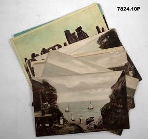
Postcards collected by R.H. Baron while on leave in England during WW1. Part of the "Robert H. Baron" (No. 3596) and Cooper Collections. See Catalogue No. 1981P for details of Baron's service. 1. Coloured coastal scene featuring yachts, beach goers and cliffs. People are standing on a pebbled beach. 2. Coloured coastal scene featuring cliffs and ocean. 3. Coloured coastal scene featuring beach, bathing machines, cliffs and town buildings. 4. Coloured coastal scene featuring beach with boats and town buildings. 5. Sepia toned photograph featuring houses. Stream running in front of house. Footpath between stream and house. 6. Coloured street scene featuring houses fronting a gravel road. 7. Black and white photograph of a street scene featuring buildings, pedestrians and horse drawn transport. 8. Sepia toned photograph of a street scene. Right side lined with houses. Single pedestrian on footpath. 9. Coloured scene featuring standing stones. 10. Coloured photograph of a ruined building overgrown with vegetation.1. Ladram Bay. 2. Ladram Bay. 3. Budleigh Salterton from East. 4. Budleigh Salterton from West. 5. Budleigh Salterton, Cottages at the Granery, 6. Budleigh Salterton, West Terrace. 7. High St. Budleigh Salterton. 8. Budleigh Salterton, Station Road. 9. Stonehenge. 10. Abbey Ruins, Waverley. robert h. baron, cooper collection, postcards, ww1 -
 Warrnambool and District Historical Society Inc.
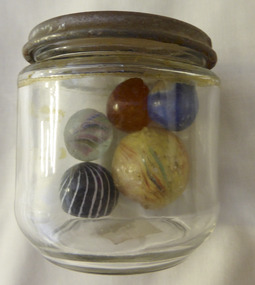
Mixed media - Toy, Marbles, Late 19th century
There is evidence of the game of marbles in the ruins of Pompeii and the tombs of Egyptians as well as early American Indians. The earliest marbles were simply rounded stones which had been polished but this was refined to handmade versions made of clay, stone and glass. It was in the late 19th century that mass production began and it gives testament to the popularity of the game that the Dyke factory of Ohio could produce 1,000,000 marbles a day. It was around 1915 that the mass production of glass marbles began. The game reached the height of popularity in the 1920-1930’s. Many were prized for their designs.The game of marbles was one of the most common games played universally, from childhood hence has a strong link with people of all ages and cultures. Five marbles in glass jar. All are various sizes ranging from large yellow streaked with red and blue, black striped with white, marbled tan, clear with multi coloured streaks and bright blue. Shapes are roughly spherical. Materials range from glass to glazed and stone. Three have pontil marks either on end.The lid of the jar has Nestle vacuumed sealed for extra protection. Use special key to open. Old sticker on base with 173 written in black lead pencil. toys, marbles, children's games, warrnambool, handmade marbles, glass marbles, clay marbles, agate marbles -
 Ballarat Heritage Services
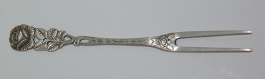
Photograph - Photograph - Colour, Cake fork with Hildersheim Rose, 2007
The Hildersheim Rose is also known as the 1000 year old rose bush, and is the oldest known living rose in the world. It grows on a wall of the Hildesheim Cathedral, a Catholic cathedral in Hildesheim, Germany, that is dedicated to the Assumption of Mary. The cathedral and the adjacent St. Michael's Church have been on the UNESCO list of World Heritage Sites since 1985. The Cathedral was destroyed by Allied bombers in 1945 during the Second World War, but the roots of the rose bush survived and it blossomed again among the ruins. According to legend, while the rose bush flourishes, Hildesheim will prosper.Photograph of a silver cake fork featuring the Hildersheim Rose, from Hildersheim, Germany.hildersheim, hildersheim rose, unesco world heritage -
 Federation University Historical Collection
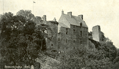
Postcard, Roslin, c1945
Roslin Castle, the seat of the St Clair Family, was founded in 1304. It is partly in ruins. According to legend some millions of pounds worth of treasure being hidden in the vaults. it is said to be under the charge of a lady of the ancient St Clair family. She is to wake from her slumber and point out the spot where the treasure lies. It is located near the village of Roslin in Midlothian, Scotland. It is located around 9 miles south of Edinburgh, on the north bank of the North Esk, only a few hundred metres from the famous Rosslyn Chapel. (See http://en.wikipedia.org/wiki/Roslin_Castle)Three postcards showing different views of Roslin Castle. .1) A stone building on a hill side, with flying flag, .2) The Courtyard, Roslin Castle .3) The Bakehouse, Roslin Castle.1) This a fine view taken from the Glen. Formerly the castle was eight storeys high, five above and three underground. .2) While at Edinburgh I went out to Roslin saw there the Castle and Church. They are both very old dating back 500 hundred years. .3) The hole in the wall is the oven, is an immense thing. A fire was lit in the oven then pulled out and the heat in the stone did the baking.roslin, rosslyn, roslin castle, st clair, spirit, ghost, baking, oven, bread -
 Lara RSL Sub Branch
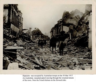
Photograph, Photograph of Bapaume
Bapaume was a large German-held town almost within sight of the Australians’ trench lines throughout the winter months on the Somme. Suddenly, from 24 February 1917 it became evident that the enemy was retiring. The British advanced after them, and by the morning of 17 March Australian troops reached the outskirts of Bapaume. The soldiers’ heightened spirits were exemplified by the band of the 5th Australian Brigade playing amid the burning ruins as they marched into the old town square on the 19th. However booby traps and time bombs had been left behind; one exploded in the town hall a week later burying men and killing twenty-five.On the Western Front, Bapaume was a coveted position between the two strategically-important areas of Artois and Somme. The Germans occupied the town in 1914 and in the final eighteen months of the war it changed hands three times.Rectangular shaped Sepia photograph with an added note underneath.Bapaume was occupied by Australian troops on the 30th Mar 1917. An Australian mounted patrol moving through the wrecked streets of the town. Note the French helmet on the forward rider.ww1, bapaume, french battlefields, lara r.s.l.world war one, australian army. -
 Wangaratta RSL Sub Branch
Album - Photo Album
Photograph album belonging to Eric Gibson Hamilton Born 20/12/1919 at Tallangatta in Victoria - VX42389 2/32nd Inf Bat AIF. It contains over 300 black and white images/photographs taken during WW2 in the Middle East at Tobruk, Libian Desert,Syria, Aleppo, Damascus,Beirut, Egypt, Palestine,Tel Aviv, Jerusalem and Gaza. Images include battles, cemeteries, ruins, cities and local way of life. Inside rear cover is a photograph of large group of nurses from the 4th A.G.H. Below each image is a hand written text in white ink. There are two images of "Jock Sparks"This photo album was created by Serviceman Eric Hamilton. The photos document Eric’s personal war experiences taken at various locations in the middle east during the second world war.Dark Blue leather bound album with red leather strap and silver plastic claspInside front cover - Eric Gibson Hamilton VX42389 2/32nd Inf. Bat. A.I.Fphotographs, ww2, middle east, eric hamilton, 2/32nd infantry battalion -
 The Beechworth Burke Museum
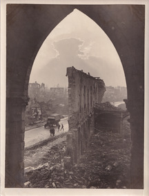
Photograph, 5 November 1917
Taken on the 5 November 1917 by James Francis Hurley, this photograph depicts the a war damaged Ypres. The shell damaged wall of the Cloth Hall is featured in the centre of the photograph, with an army vehicle and personal are located on the street beneath the ruined wall.First Battle of Ypres, (October 19–November 22, 1914), first of three costly World War I battles centred on the city of Ypres (now Ieper) in western Flanders. Attempted flank attacks by both the Allies and the Germans failed to achieve significant breakthroughs, and both sides settled into the trench warfare that would characterize the remainder of the war on the Western Front.Black and white rectangular reproduced photograph printed on mate photographic paperReverse: 6525/ (A copyright and reproduction notice from the Australian War Museum, printed upside-down in blue ink)military album, burke museum, world war one, world war 1, ww1, ypres, belguim, ruins, first battle of ypres, james francis hurley -
 Eltham District Historical Society Inc
Photograph, Fay Bridge, Former Glynn's Dairy Farm, Glynns Road, North Warrandyte, 31 August 2018
Glynn’s farm Originally Section 7, Parish of Nillumbik marked Aborigine Reserve in 1866 Crown Allotment 8, Section 7, Parish of Nillumbik, County of Evelyn, Certificate of Title Volume 4095, Folio 818.835, approx. 93 acres purchased by Joseph Panton in 1881 for £1/acre and known as Panton’s Point. By 1924 owned by S.S. Sergeant and called Riverswood. Sergeant commissioned Edna Walling to design the garden. In September 1929 the property was sold at auction by Mortgagee’s sale. Described as well built, brick, tile roof, Attic Villa containing downstairs 7 good rooms, bath, scullery, inside lavatory, etc. Upstairs 2 bedrooms and sleep out. Outbuildings compromising of brick and weatherboard wash house, stables, workshop, feed room, cow bails, large G.I. Hay shed, etc In January 1931 Riverswood property was proclaimed a sanctuary for native game for the entire year. A private swing bridge crossed the river at Pound Bend was known as Pearson’s bridge after C.W.K. Pearson who bought Riverswood in the early 1930s. The bridge was swept away in the December 1934 floods. Riverswood was sold by C.W.K. Pearson at auction on 25 November 1936. Described as a beautiful farm home of 93 acres and over one mile of River Yarra frontage, modern brick residence, lovely garden, rich river flat pastures, model poultry farm. The fine brick home was destroyed on Black Friday (13 Jan.) 1939. It was still a ruin when the Evelyn Evans purchased Waikowhane above Riverswood in 1940. The Glynn family purchased the Riverswood property in 1941 from Robert and Emily Hannon. Their son Kenneth Patrick Glynn inherited the property and he set about clearing the land during WW2 selling wood. Prior to marriage, Kenneth was living alone on the farm in a house he had built from whatever was available. He used the bluestone foundations from the original fine brick home. He met and married Honora Elizabeth Drew in early 1945 and their daughter Anna grew up on the farm. It was compulsorily acquired by the Board of Works in 1976 who then rented the house out in the 1980s. The property was transferred to Melbourne Parks and Waterways in 1996. Waikowhane was a pretty timber house built on top of the hill on 50 acres above Riverswood by retired nurse Jessie MacBeth. (This would be at the intersection of Glynns Road and Overbank Road where the big water tank is now situated on what was once James Orford’s property.) It was also destroyed Black Friday and she rebuilt it from the plans living in a caravan on site supervising the build. It was almost complete when she died May 1939. The property was bought by Evelyn Evans (a city girl) and her estranged husband in 1940. She had two sons, one only 9 months old at the time. It was a timber house with no power or water connected. The Ewen Cameron family bought Waikowhane in 1957. They had to evacuate when the 1961 bushfires swept through. The house was saved by Matcham Skipper. It was demolished by Melbourne Water in the 1990s when they acquired it.fay bridge collection, 2018-08-31, glynn's, glynn's dairy farm, glynns road, north warrandyte, parks victoria, ruins, riverswood, kenneth patrick glynn -
 Bendigo Historical Society Inc.
Photograph - THE SPRINGS, SEDGWICK
Photograph - black and white. Photograph of 'The Springs, Sedgwick', 14 miles from Bendigo. Rocky, hilly landscape with scattered trees, two chimneys on the main building in the centre, horse and rider approaching the building. Also 3 current photographs taken by Phillip Wilkin on July,2009. The 3 current photo's showing bluestone ruins - it is the same building on the left of the old photo - not the building with 2 chimney's, the one hidden behind trees (you only see part of it). Phillip's grandfather (Charles Wirth) moved here in 1901, along with his parents and grew up in that building (now ruined), the family still own the land.place, land, the springs, sedgewick., the springs, sedgwick. -
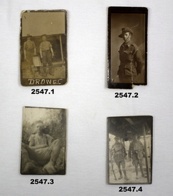 Bendigo Military Museum
Photograph - PHOTOGRAPHS WW1, c. 1915 - 1919
Items relating to the collection re Alexander Norman Cummin No 18, 38th Batt AIF, his brother Harold Nesbit Cummin No 1239 Camel Corp. Refer 2535P (Alexander) 2530.3P (Harold) for their service details. .6) Graves photo. On the left, Sydney Graham Issell. He had 4 years pre war service in Senior cadets and Citizens Forces reaching the rank of Sgt. Enlisted on 8.2.1916 No 912 with the rank of Cpl, C Coy 38th Batt age 21 years 11 months. Embark for England 20.6.1916, promoted L/Sgt, embark for France 22.11.1916, hospital 13.5.1917 (NYD) rejoin unit 19.5.1917, WIA 29.5.1917 GSW chest then restated GSW Back, severe, rejoin unit 12.3.1918, KIA 1.8.1918. On the right, Harold James Fraser. He had 5 years pre war service in the Cadets and Citizens Forces. Enlisted on 27.10.1916 No 2802 6th reinforcements 38th Batt age 22 years. Embark for England 16.12.1916, moves through 10th, 14th Training Batt’s then 66th Batt on 28.4.1917, promoted Sgt and alloted No 2802A, embark for France 25.8.1917 as reinforcement 38th Batt, awarded the Military medal (MM)) 12.10.1917 East of Eypres, KIA 1.8.1918. Both were buried at Vaire Wood near Corbie. .1) 2 Australian soldiers in fatigues with what looks like a cooking apparatus, with letters below DROW EC (stylised). .2) 1/2 length portrait of an Australian soldier. .3) Casual portrait of a soldier sitting in fatigues, probably Sandy. Boots look muddy, scrub in background. .4) Portrait of 2 soldiers (allied) fully armed & wearing helmets. .5) Portrait of a soldier (allied) fully armed & dangerous. .6) Black & white photo of 2 graves with white crosses. Soldiers left cross: No 912 SGT SG ISSELL 38 BN AIF, Soldier right cross: No 2802 SGT HJ FRASER 38 BN AIF. .7) Black & white photo showing 2 Australian soldiers casually dressed in the ruins of an old factory. .8) Black & white mini photo showing building ruins & what appears to be derelict boilers. .9) Black & white mini photo showing what appears to be a WWI German soldier kamerading (surrendering). This is probably posing in captured enemy clothing. 10.) Black & white mini photo showing camels at rest. .11) Black & white mini photo showing a blown up British pattern tank MK1 on sandy terrain. A track has detached & curled up over the front of the tank. .1) verso: “Me & Sandy Port De Nieppe May 1917” .2) verso: “Taken in Liverpool, England while on <> leave Jan 1918. To Mother Father & all at home with love from Sandy”photography-photographs, military history - army, 38th -
 Ballarat Heritage Services
Photograph - Photograph - Colour, Former Lake Condah Aboriginal Mission, 17/04/2016
The Lake Condah Mission site includes bluestone ruins and a reconstructed timber building, as well as the cemetery which were part of the original settlement. With European settlement in the 1830s came conflict. Gunditjmara people fought for their land during the Eumerella wars, which lasted more than 20 years. As this conflict drew to an end in the 1860s, many Aboriginal people were displaced and the Victorian government began to develop reserves to house them. Many Aboriginal people refused to move from their ancestral land and eventually the government agreed to build a mission at Lake Condah, close to some of the eel traps and within sight of Budj Bim (Mt Eccles). The mission opened in 1867. The Mission was formally closed in 1918, and Aboriginal people were forced off the Mission, some moving to Lake Tyers. The Gunditjmara protested against the Mission’s closure and many continued to reside in the buildings until the majority of the reserve land was handed over to the Soldier Settlement Scheme in the 1940s. The mission was destroyed by the government in the 1950s in an effort to force the integration of Gunditjmara people with the general community but the Gunditjmara people continued to live in the area and protect their heritage. The mission lands were returned to the Gunditjmara in 1987. Lake Condah Mission is a place with special meaning to the Gunditjmara community - as a community meeting place, an administrative centre, a symbol of political struggle and a link to family histories. As a result the Gunditjmara community do not want open public access to this site. Key Features of Interest Ruins of stone cottages and plot remains of buildings such as the church Reconstructed dormitory building (https://www.budjbim.com.au/visit/cultural-sites/lake-condah-mission/?gclid=EAIaIQobChMIz6j36ZvF-QIV8ZhmAh2tmA3qEAAYASAAEgLxrvD_BwE, accessed 2022)Colour photographs of the former Lake Condah Aboriginal Missionlake condah, lake condah aboriginal mission, aborigines, aboriginal, gunditjmara, eumerella wars -
 Bendigo Military Museum
Photograph - PHOTOGRAPHS WW1 & ENVELOPE, C. WW1
.1) Registered letter envelope addressed to Mr Norm Tucker, Bannister St, Bgo. Sepia colour photos located in Egypt & Middle East: .2) - .11) Buildings. .12) - .19) Individual & groups of local people. .20) - .21) Railway buildings. .22) - .27) Ruins & old buildings. .28) - .29) Local people at work. .30) Boat. .31) Yanky boat Suez Canal 1916 when they were neutral. .32) Horses - Reinforcement on board for 6th ALH. Black & white photos: .33) Warship. .34) - .35) Buildings & people. .36 - .37) Zoo animals. .38) Card, colour picture of soldier & a little girl.photography-photographs, documents - envelopes, military history, passchendaele barracks trust -
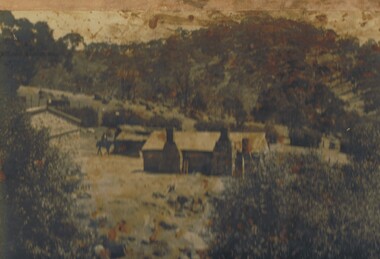
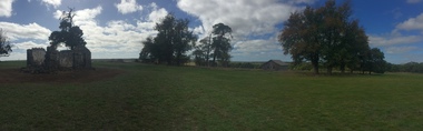
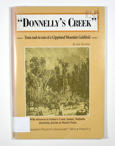 Marysville & District Historical Society
Book - Paperback book, Donnelly's Creek-From rush to ruin of a Gippsland Mountain Goldfield, 1990
A history of the Donnelly's Creek gold mine in VictoriaPaperback. Front cover has a drawing depicting two horses carrying packs followed by a man mounted on a horse. There is also two men on foot following with packs and walking poles. They are walking along a forest track that has some tree stumps alongside it.The back cover has two colour photographs. The top one is of an old wooden building with what appears to be an attached lean to. Both of the buildings have stone chimneys. There is a group of people sitting and standing outside the main building. The bottom photograph appears to be the ruins of a building and a fence. There are three people viewing the ruins.The captions accompanying the photographs are: History revisited - O'Sullivans Old Toombon Hotel Recreated and Remnants of a Bygone Mining Era.Stamp of the Marysville & District Historical Society Inc / P O Box 22 / Marysville 3779gold, gold miner, gold mining, gold field, gippsland, victoria, australia, history, fulton's creek, seaton, walhalla, aberfeldy, jericho, wood's point -
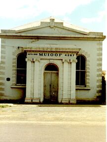 Port Fairy Historical Society Museum and Archives
Photograph
This building is the second of the Manchester Unity Independent Order of Oddfellows rooms the first built in 1862 and opened in that year on the fifteenth anniversary of the foundation of the Lodge in Belfast/Port Fairy. In 1872 a 35foot addition was added to the back and in 1873 the grand porch was added. The hall was destroyed by fire in 1875 and the only item saved was the cedar Dispensation frame of the past Grand Masters made by John Gallin that now resides in the Historical Society Rooms. The Trustees bought another building which occupied the land now occupied by the National Australia Bank on the corner of Sackville and Cox Streets but it was not suitable so they decided to re-instate the building whose ruins in the meantime had been used by Cobb and Co. This new building was designed by Charles Neylon an architect and built by Robert Ireland. The completed building was re-opened in December 1888 with four front rooms, a mezzanine floor and a hall measuring 32' by 26' and capable of holding 200. The Trustees of the Loyal Prince Albert Lodge sold the building in 1978 and is now a private home.Coloured photograph of Imposing M.U.i.O.O.F. Society building with a faux columned portico, double door entry two large windows either sideinstitution, loyal prince albert lodge, m.u.i.o.o.f., manchester unity independent order of oddfellows, society, muioof hall pt fairy -
 Glen Eira Historical Society
Album - Album page, Royston, Kooyong Road, Circa 1972
This photograph is part of the Caulfield Historical Album 1972. This album was created as part of a project from approximately 1966-1972 by the Caulfield Historical Society to assist in identifying buildings worthy of preservation. This album is related to a Survey the Caulfield Historical Society developed in collaboration with the National Trust of Australia Victoria and Caulfield City Council to identify historic buildings within the City of Caulfield that warranted the protection of a National Trust Classification. Photographers Jenny O’Donnell and Trevor Hart, members of Caulfield Historical Society. Some photographs are older and from unknown sources. All photographs are black and white except where stated. Vol 1 of 4 "Caulfield's Heritage" p34 states that this mansion was demolished in 1972.Page 115 of Photograph Album with two colour photographs (one portrait and one landscape) of different views Royston in its garden.Handwritten: 115 [bottom left]trevor hart, caulfield north, kooyong road, 1860's, mansion, ornamented corner stones, royston, renwick, curved windows, ruins, bay windows, victorian architectural style, polychrome bricks, abandoned buildings -
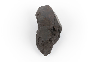 The Beechworth Burke Museum
Geological specimen - Brown coal
This particular specimen was recovered from the Lal Lal Coal and Iron Mine in Victoria, 19km from Ballarat. Brown Coal was discovered here in 1857, just alongside the Geelong to Ballarat Railway line. This discovery of lignite (brown coal) was the first in Victoria, which would bring important benefits to the region and state, both of which had previously been reliant on coal imports. In the 1860s, iron ore was found just 5km from Lal Lal, and the area was converted into an Iron Ore Mine. The Lal Lal Iron Mining Company took over operations in 1874, who then peaked iron production in 1884. This mine continued operations until June 1884, when the blast furnace was extinguished and never recommenced. The blast furnace at Lal Lal is considered one of the most important and highly significant sites ion early industrial history in Australia, as it is the only remaining best furnace from the nineteenth century in the Southern Hemisphere. The furnace ruins are 17 metres high, and are clearly visible today on Iron Mine Road, Lal Lal, near the Bungal Dam. This specimen of Lignite (brown coal) is significant, as it was mined from the area where brown coal was first discovered in Victoria, leading to an important and controversial future of the mining and use of brown coal in this State. The Victorian Heritage Database has listed the Lal Lal Coal Mine with local significance, with their Statement of Significance stating: "The Lal Lal coal mine is historically significant as the site of the first discovery of lignite (brown coal) in Victoria, and one that promised important benefits to regional and state industries that were reliant on coal imports at the time. The significance of the stie is reduced by the poor state of preservation of the coal mining and processing fabric". This specimen is part of a larger collection of geological and mineral specimens collected from around Australia (and some parts of the world) and donated to the Burke Museum between 1868-1880. A large percentage of these specimens were collected in Victoria as part of the Geological Survey of Victoria that begun in 1852 (in response to the Gold Rush) to study and map the geology of Victoria. Collecting geological specimens was an important part of mapping and understanding the scientific makeup of the earth. Many of these specimens were sent to research and collecting organisations across Australia, including the Burke Museum, to educate and encourage further study.A hand-sized light-weight, soft and combustable sedimentary rock specimen, that is dark brown in colour. The specimen has jagged edges, as though parts of the rock have crumbled away. Brown coal, or Lignite, is formed naturally from compressed peat, and is typically found in natural basins. The stages to the formation of coal ('coalification') begin with plant material and wood, which will decay if it is not subjected to deep burial or heating, and turn into Peat. Peat, when sufficiently compressed naturally, will turn into Brown Coal (Lignite), and finally into Black Coal (sub-bituminous, bituminous and anthracite). Each successive stage has a higher energy content and lower water content. It is brownish-black in colour. Brown Coal has a high moisture content, between 50 and 75 percent, and a low carbon content. Some Brown Coals may be stratified, with layers of plant matter, which means little coalification has occurred beyond the peat natural processing stage. When Brown Coal is submerged in dilute nitric acid or boiling potassium hydroxide solution, it reacts to produce a reddish solution, of which higher-ranked coals do not. When brown coal is pulverised and burned in boilers, the steam is used to drive turbines, which generates electricity. It is the lowest rank of coal, as when burned, it creates a relatively low heat content, which in turn does not create a great output of steam. burke museum, beechworth, indigo shire, beechworth museum, geological, geological specimen, mineralogy, brown coal, brown coal specimen, lignite, lal lal, lal lal coal mine, lal lal iron mine, ballarat, blast furnace -
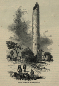 Ballarat and District Irish Association
Image, Round Tower at Monasterboice, c1864, c1864
The historic ruins of Monasterboice are of an early Christian settlement north of Drogheda in County Louth, Ireland. It was founded in the late 5th century by Saint Buithe who died around 521, and was an important centre of religion and learning until the founding of nearby Mellifont Abbey in 1142. The site houses two churches built in the 14th century or later and an earlier round tower, but it is most famous for its 10th century high crosses. The round tower is about 35-metres tall, and is in very good condition, although it is not possible to go inside. The passage of time has laid down layers of earth so now the doorway is almost at ground level. The monastery was burned in 1097. The 5.5-metre Muiredach's High Cross is regarded as the finest high cross in the whole of Ireland. It is named after an abbot, Muiredach mac Domhnaill, who died in 923 and features biblical carvings of both the Old and New Testaments of the Bible. The North and West crosses are also fine examples of this kind of structure, but these have suffered much more from the effects of the weather. (http://en.wikipedia.org/wiki/Monasterboice)Image of a round tower in a graveyard. It is the Round Tower at Monasterboiceballarat irish, monsasterboice -
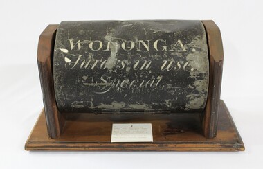 Wodonga & District Historical Society Inc
Functional object - Jurors' Selection Barrel, Wodonga Court House
The barrel was used in the Wodonga Court House as part of the selection process for jurors. It was a standard issue barrel used throughout Victoria. It was retrieved from the ruins of the court house which was destroyed by fire. It was then donated to the Wodonga Historical Society. The timber display stand was made and donated by Jake Tooley, a Wodonga Historical Society member, The Court House was situated in the Customs Store building alongside the Wodonga Police Station in 93 High Street. (The house where the Police Station was had originally been the home of the Customs Officer). In early 1964, the court house building was burnt beyond repair and furniture and other property destroyed. The cause of the fire was never found. The Police Station was lucky to survive but only because of the efforts of the local Fire Brigade. After the fire, the court was held first at the old Fire Station premises near where the Wodonga Post Office is near Woodland Grove, then it moved to a vacant building in Mitchell Street which was later turned into a Child Care Centre. Foundations for the new court house in Elgin Street were laid in October 1965 Local significance due to its use in the Wodonga Court House and its survival of a major fire. State significance as it documents a procedure used in the Victorian Court and Legal system Cylindrical metal-iron barrel painted black with writing stenciled on the front in white The timber mount was made for storage and display is not part of the original object,Inscription on Barrel "WODONGA./ Jurors in use./ Special"wodonga court, jurors, selection, legal system, fire -
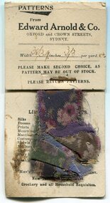 Orbost & District Historical Society
documents, C1915 -1920s
These items were found in the ruins of a house/ hut located along the Clarkesville Road at Bendoc. The donor, David Buntine was stationed in Bendoc in 1969-1971 managing timber harvesting operations for VicForests. The swatches of curtain material are from Edward Arnold & Co Department Store of Oxford and Crown Streets, Sydney. The six tag labels are from Schute, Bell & Co Ltd - Wool & Produce Brokers, Sydney. There is a carbon copy of a receipt from the Shire of Orbost to Mr J. Dent. It is dated 9-10-1915 and is for the amount of 10 shillings. There is a receipt for a gun licence dated, 18-5-1920 and is from Edward Dent for 10 guineas. The invoice / receipt is for men's clothing and cups from Peter Joseph General Storekeeper at Delegate and is dated September 1920. There is an overdue notice to Isaac Dent, Bendoc for a 12 month subscription to "The Bombala Times" - W.G. Tweedie. Isaac Dent was married to Margaret Leslie and had six children - Isaac, James, Mary Ann, Charles, Elsie and Joseph. They made their home at Burrumbooka, near Bombala. The Bombala Times newspaper has been continually published since 1863. It was owned by the Johnson family between 1938 and 1975. These documents are early 20th century records of business transactions. The Dent family were early settlers in the Bendoc / Bombala district.A collection of invoices, receipts, labels and a card of material swatches. 3095.1 is a rectangular card with swatches of material stapled to it. 3095.2 and 3095.3 are rectangular pull apart labels. 3095.4 and 3095..5 are carbon copies of receipts. 3095.7 is an overdue notice. All documents have hand-written and printed information.dent-isaac-bombala edward-arnold-&-co schute-bell-&-co joseph-peter-delegate bombala-times -
 Glenelg Shire Council Cultural Collection
Book, People of the Lake - the story of Lake Condah Mission, n.d
27,000 years ago molten lava pouring from the eruption of Budjbim (Mt. Eccles) formed Lake Condah and the unique landscape that surrounds it. Over time this area known as "The Stony Rises" or "The Stones" became an important geological area for Koories and, later, Europeans.12 page A4 size booklet, cream with brown print.27,000 years ago molten lava pouring from the eruption of Budjbim (Mt. Eccles) formed Lake Condah and the unique landscape that surrounds it. Over time this area known as "The Stony Rises" or "The Stones" became an important geological area for Koories and, later, Europeans.aboriginal history, gunditjmara, lake condah, mission history, budj bim -
 Ballarat Heritage Services
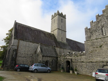
Photograph - Colour, St Nicholas' National School, Adare, Ireland, 2016, 09/2016
St Nichols' National School, Limerick, Ireland, is near the Adare Church, built on the grounds of good land beside a river where three groups of monks made their home during the Middle Ages. The Church was formerly the Black Friar's Abbey. The monastery was founded by John, Earl of Kildare, in 1315. The name of the old parish church was St Niholas where the school derived its name. On 2 June 1808 the local vestry meeting of the Church decided to abandon the old parish church of St Nicholas, the ruins of which are on the Estate, and the old Black Abbey was restores. The remains of the monasteries of all three orders of monks are in relatively good order still (considering their age) and two of them have been restores for worship. The first is the Trinitarian Abbey, otherwise known as the White Abbey, which is in the centre of the village of Adare. This was once the mother-house of a small influential order which had as its main object the ransoming and redeeming of Christian captives from the Moslems. The second is the ruin of the Franciscan Abbey in the demesne, beside the gold course. The third is the Augustinian Priory or the Black Friars' Abbey founded in 1315 by John, Earl of Kildare. Reference: Adare Church by The Right Reverend R. Wyse Jackson LITT.D., LL.D., D.D., Bishop of Limerick 1961-1970.st nicholas' national school, national school, education, schools, adare, ireland -
 Federation University Historical Collection
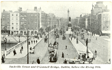
Postcard - Postcards - black and white, Coleman & Co, Dublin before and after the Rising, 1916, c1916
The Easter Uprising took place in April 1916 in Dublin and is one of the pivotal events in modern Irish history. At the end of the Easter Uprising, 15 men identified as leaders were executed at Kilmainham Jail. To some, these men were traitors, to others they became heroes. (http://www.historylearningsite.co.uk/1916_easter_rising.htm, accessed 16 April 2014) Organised by seven members of the Military Council of the Irish Republican Brotherhood,[3] the Rising began on Easter Monday, 24 April 1916, and lasted for six days. Members of the Irish Volunteers — led by schoolmaster and Irish language activist Patrick Pearse, joined by the smaller Irish Citizen Army of James Connolly, along with 200 members of Cumann na mBan — seized key locations in Dublin and proclaimed the Irish Republic independent of the United Kingdom. There were some actions in other parts of Ireland: however, except for the attack on the Royal Irish Constabulary barracks at Ashbourne, County Meath, they were minor. With vastly superior numbers and the use of artillery, the British army quickly suppressed the Rising, and Pearse agreed to an unconditional surrender on Saturday 29 April. Most of the leaders were executed following courts-martial, but the Rising succeeded in bringing physical force republicanism back to the forefront of Irish politics. (http://en.wikipedia.org/wiki/Easter_Rising, accessed 16/04/2014) Sackville Street Dublin is now known a O'Connell Street.Seven black and white postcards showing photographic scenes before and after the Rising in Dublin.chatham family archive, chatham, holmes, ireland, dublin, uprising, sackville street, o'connell bridge, citizen army, liberty hall, henry street, nelson's pillar, post office, arnott's, abbey street, ruins, hotel metropole, the rising, easter uprising, easter rebellion, o'connell, chatham family archive, chatham, holmes, ireland, dublin, uprising, sackville street, o'connell bridge, citizen army, liberty hall, henry street, nelson's pillar, post office, arnott's, abbey street, ruins, hotel metropole, the rising, easter uprising, easter rebellion, o'connell -
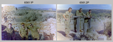 Bendigo Military Museum
Photograph - 4th Field Survey Squadron Adventurous Training, Unknown Location, SA, 1994
This is a set of 31 photographs of 4th Field Survey Squadron undergoing adventurous training held at unknown locations in South Australia, in 1994. It is also possible the training was in the Grampians region of Victoria. Off-road driver training and abseiling were key activities of this adventurous training as well as teamwork, leadership, and field craft. Elements from units of the Army Reserve may have participated in the training. See items 6562.33P, 6563.33P and 6564.28P for more photos taken during this training activity.This is a set of 31 photographs of 4th Field Survey Squadron personnel undergoing adventurous training held at unknown locations in South Australia in 1994. The colour photographs are on 35mm negative film and are part of the Army Survey Regiment’s Collection. The photographs were scanned at 96 dpi. .1) - Photo, colour, 1994. Old ruins. L to R: SGT Steve McGuiness, SPR Chris Pearse, SPR Mark Linwood. .2) - Photo, colour, 1994. Old ruins. L to R: CPL Steve Wegener, SPR Mark Linwood. SGT Steve McGuiness. .3) - Photo, colour, 1994. Old grave. SPR Mark Linwood. .4) to .7) - Photo, colour, 1994. Driver training. Unidentified personnel. .8) - Photo, colour, 1994. Driver training. CPL Steve Wegener. .9) to .12) - Photo, colour, 1994. Driver training. Unidentified personnel. .13) - Photo, colour, 1994. Driver training and hiking. L to R: SPR Greg Richards, SPR Mark McInerney. .14) - Photo, colour, 1994. Driver training and hiking. L to R: SPR Chris Pearse, WO2 Simon ‘Andy’ Capp. .15) - Photo, colour, 1994. Driver training and hiking. Unidentified personnel. .16) - Photo, colour, 1994. Driver training and hiking. L to R: CPL Steve Wegener, CAPT Rob Gray, unidentified (x2), SPR Chris Pearse, WO2 Simon ‘Andy’ Capp. .17) to .18) - Photo, colour, 1994. Driver training. Unidentified personnel. .19) - Photo, colour, 1994. Driver training and hiking. L to R: WO2 Simon ‘Andy’ Capp, SPR Chris Pearse, CPL Stuart Adrain, SPR Mark McInerney. .20) - Photo, colour, 1994. Driver training and hiking. L to R: CPL Stuart Adrain, unidentified, CAPT Rob Gray, WO2 Simon ‘Andy’ Capp, SPR Chris Pearse, SPR Mark McInerney. .21) - Photo, colour, 1994. Driver training and hiking. Unidentified personnel. .22) - Photo, colour, 1994. Driver training and hiking. L to R: unidentified, CPL Stuart Adrain, SPR Mark McInerney, CAPT Rob Gray, remainder unidentified. .23) - Photo, colour, 1994. Abseiling. L to R: SGT Steve McGuiness, unidentified, CPL Steve Wegener, CPL Stuart Adrain. .24) & .25) - Photo, colour, 1994. Abseiling. WO2 Simon ‘Andy’ Capp. .26) - Photo, colour, 1994. Abseiling. CAPT Rob Gray. .27.) to .31) - Photo, colour, 1994. Abseiling. Unidentified personnel..1P to .31P – There are no personnel identified. ‘1994 ADV TRAINING’ annotated on negatives sleeve.royal australian survey corps, rasvy, 4 fd svy sqn -
 Bendigo Military Museum
Postcard - POSTCARD, FARNHAM, U.K, Valentine's Series, cWW1
1. Florrie is a relative living in Farnham. 2. R.H. Baron married Elsie Keast in 1921. All cards relate to R.H. Baron's visits to Farnham whilst on leave to see Florrie. Part of the 'Robert H. Baron', no.3596 and Cooper Collection. See Catalogue No. 1981P for details of Baron's service.1. Coloured scene of a ruined castle and surrounding gardens. 2. Coloured scene of a garden with building and ruins in background. 3. Coloured photograph of a red brick building with battlement. 4. Coloured street scene with buildings, horse drawn transport and pedestrians. 5. Coloured photograph of the nave of a church looking towards the alter. 6. Coloured street scene with buildings and horse drawn transport. 7. Coloured view across a street to a white walled building with horse drawn transport. 8. Coloured photograph of a church, graveyard in foreground. 9. Black and white photograph of a castle surrounded by trees. 10. Black and white photograph of a forest scene with people standing on a bridge. 11. Black and white photograph of a street scene with buildings, horse drawn transport and people. 12. Black and white photograph of the tower of a church. Graveyard in the foreground. 13. Black and white photograph of a street scene with buildings, horse drawn transport and pedestrians. Castle on the hill in background. 14. Black and white photograph of a street scene with buildings, motor cars and pedestrians. 15. Black and white photograph of a street scene with buildings, motor cars, horse drawn transport and pedestrians. 16. Black and white photograph of a wooded valley. Houses on a hill in the background. 17. Black and white photograph of an avenue of trees. 18. Black and white photograph taken in a park. Three people standing on a bridge over a stream.1. The Keep, Farnham Castle. Handwritten in black ink on back: 'This is one of the pretty places around Farnham. I was all once here with Florrie. Bob' 2. In Castle grounds, Farnham. Handwritten in black ink on back: 'Dear Elsie, these are some places that visit... when I was down at Flories place. Bob xxxxxx' 3. Farnham Castle. 4. West Street, Farnham. 5. Parish Church, Farnham. 6. Castle Street, Farnham. 7. The Church House, Farnham. 8. Parish Church, Farnham. 9. Farnham Castle. 10. Red Hill Hanger, Farnham. Handwritten in black ink on back: 'Letter to R.H. Baron's sister - no date.' 11. South Street, Farnham. Handwritten in black ink on back: 'this part of the place I spent my leave at this is where Florrie is.' 12. Farnham Parish Church. Handwritten in black ink on back: 'Letter to R.H. Baron's mother - dated 24 July 1918.' 13. Castle Street, Farnham. Handwritten in black ink on back. 'I think you will know where this is as I have told you quite a lot about Farnham, it is where Florrie is. I spent my leave here. This is Castle Street and the castle is right on the top of the hill.' 14. Borough, Farnham. Handwritten in black ink on back. ' This is the place where Florrie lives. I spent my last leave their (sic), Bob.' 15. West Street, Farnham. Handwritten in pencil on back. 'Pte R.H. Baron, 57 Battalion, Australian Imperial Forces Abroad.' 16. Lower Bourne Valley, Farnham. Handwritten in black ink on back: 'Partial letter from R.H. Baron to his sweetheart.' 17. The Avenue, Farnham. Handwritten in black ink on back: 'Partial letter from R.H. Baron to his mother.' 18. Recreation Ground, Farnham. Handwritten in black ink on back: 'Letter to Doris from R.H. Baron - no date.' robert h. baron, cooper collection, postcards, farnham uk