Showing 13362 items matching " stations"
-
 Queenscliffe Maritime Museum
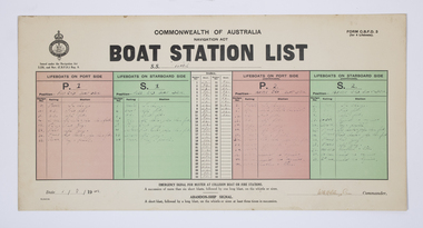
Document - Form, Boat Station List
The Court of Marine Inquiry found that the steering gear had failed as the SS Time entered Port Phillip Heads. It was established that the fault lay with the Lloyd's surveyor for not detecting the fault when the Time had been classified Al. No blame was attached to the master. Two Queenscliff fishermen purchased weck for 950 pounds (insured value 30,000 pounds)and its timber cargo - handsome profit. Cargo and most fittings of value recovered. Wreck visible until early 1960s, until during a storm it slid off northern side of Nepean reef and broke up in 20 feet of water. The most noteworthy shipwreck to date at the heads.Two Queenscliff fishermen purchased the weck for 950 pounds (insured value 30,000 pounds) and its timber cargo - handsome profit. The cargo and most of the fittings of value were recovered. The wreck was visible until the early 1960s, until during a storm, it slid off the northern side of Nepean Reef and broke up in 20 feet of water. The most noteworthy shipwreck to date at the heads.A Commonwealth of Australia Navigation Act, Boat Station List form, showing the names of crew assigned to each of 4 lifeboats on the Port [P] and Starboard [S] sides of the SS Time dated 1 August 1949.Form C.B.D.F 3 for 4 lifeboats; Boat Station List navigation act, ss time, port phillip, shipwrecks, lifeboat rules -
 Ringwood and District Historical Society
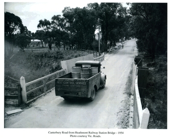
Photographs / Album Pages, Canterbury Road from Heathmont Railway Station Bridge 1954, 1954
Houghton & Byrne Pest Service Truck on Canterbury Road crossing Heathmont Railway Station Bridge 1954. Photo courtesy Vic. RoadsCanterbury Road from Heathmont Railway Station Bridge - 1954. Photo courtesy Vic. Roads -
 Sunbury Family History and Heritage Society Inc.
Photograph, c
The photograph shows a view of Sunbury Railway station as it was in the 1970s and earlier. he image is looking south to the railway crossing at Station Street and the storage sheds which were along Platform 1, where the trains for Melbourne left.A coloured photograph of a railway station and pedestrian bridge.sunbury -
 Kew Historical Society Inc
Photograph - Kew Railway Station, Eva Grant, 1959
Eva Grant's three photograph albums, from which this individual photograph has been taken, contain important images of historic buildings in Kew, Victoria and Australia during the 1950s to the 1970s. The annotations in the album establish their date and provenance. Small black and white photograph of the Kew Railway Station in 1959. The photograph was taken by Kew Historical Society member Ms Eva Grant and placed in one of her scrapbooks (Historic Buildings, Kew, 1958-78). The photograph is from page 2."THE LAST PHASE. JAN 1959. KEW RAILWAY STATION"kew railway station -
 Puffing Billy Railway
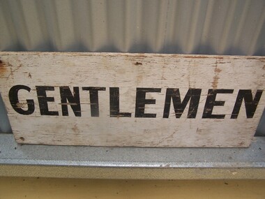
Station Toilet Gentlemen sign
Station Sign - Toilet Gentlemen An obvious sign for a convenience. The use of the term Gentlemen was shortened to Men at a later time. Historic - Victorian Railways Station Sign - Toilet GentlemenStation Sign - Toilet Gentlemen sign wooden rectangle Station name sign pained white background with black lettersGentlemenpuffing billy, victorian railways, station sign, toilet gentlemen sign -
 Puffing Billy Railway
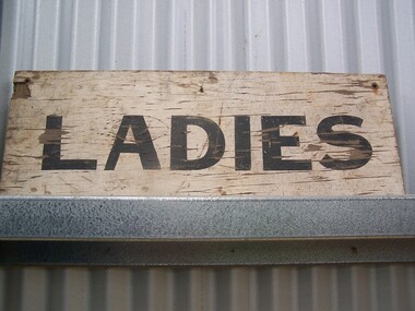
Station Toilet Ladies sign
Station Sign - Toilet Ladies An obvious sign for a convenience. The use of the term Ladies was altered to Women at a later time.Historic - Victorian Railways Station Sign - Toilet LadiesStation Sign - Toilet Ladies sign wooden rectangle Station name sign painted white background with black lettersLadiespuffing billy, victorian railways, station sign, toilet ladies sign -
 Surrey Hills Historical Society Collection
Photograph, Surrey Hills Station and car park
There are 3 tracks; the third track was built in 1971, which gives an approximate date for the photo. At this time the original station buildings were demolished and replaced by buildings constructed from concrete bricks and a second subway replaced the overhead footbridge. According to Roderick Smith, a local railway enthusiast, originally there had been 3 railway houses at the Mont Albert end of the northern car park. These were demolished to extend the car park. Certainly 8 Bedford Avenue, built as the station master's house was demolished at this time. The palm tree had been planted in the station master's front garden and was retained in a small garden bed within the car park. A black and white photograph of a station with cars parked on both sides of the 3 tracks. A Harris train is departing the station heading towards Mont Albert. A palm tree is prominent in the station car park to the north.1971, surrey hills station, railway stations, car parks, public transport, trains, railway lines, palm tree -
 Whitehorse Historical Society Inc.
Article, Station spruce up, 31/10/1990 12:00:00 AM
Nunawading station chosen for a pilot scheme to encourage the community to take care of its local stations.Nunawading station chosen for a pilot scheme to encourage the community to take care of its local stations. Nunawading Apex Club painted the station. Project organizer for Apex, Peter Woolfe. Wattyl Paints supplied the paint.Nunawading station chosen for a pilot scheme to encourage the community to take care of its local stations. railways, nunawading railway station, apex club, nunawading, woolfe, peter -
 Puffing Billy Railway
Emerald Station Sign
Station Sign - Emerald Emerald Station is situated on the Puffing Billy Railway in Victoria, Australia. It was opened with the Railway on 18 December 1900 and comprised a platform track and a loop siding. A passing loop was added between the two a few years later. There was also a spur siding off the Down end of No. 3 Road. Two standard 12 ft by 20 ft timber portable station buildings with a Van Goods Shed between (all adjoining) were provided on the platform and a Goods Shed on the No. 3 Road loop siding. Other buildings included Tea Rooms, lamp room and toilets along with a cattle race and loading bank. The station building was later reduced in length by one of the portables which housed the General and Ladies' waiting rooms. Emerald today remains very similar to the early days, but has had other Roads added into a Carriage Workshops, a turntable and storage sidings. Also, a Signal and Telegraph Branch depot in the form of a large Goods Shed and a multi-purpose yard building in the form of a Locomotive Depot administration building have been added. During 2009, the station building underwent stage one of an internal restoration to its former glory. ref: https://en.wikipedia.org/wiki/Emerald_railway_station,_Victoria photos at http://www.vicrailstations.com/Gembrook/Emerald/Emerald.html Historic - Victorian Railways Station sign used at Emerald Station Station Sign - Emerald Metal rectangle Station Name Sign with white enamel back ground and black lettersEmeraldstation sign, puffing billy, emerald station -
Ringwood and District Historical Society
Plastic packet, PTC - Maroondah City Council, Public Transport Commission, Ringwood Railway Station Development Study, Interchange Upgrade, Community Workshops - various printed documents 1995-2013, 1995 to 2013
The urban consulting group commissioned Maroondah City Council and the Public Transport Feasibility Study, Ringwood Railway Station to be upgraded October 1995Various printed documents relating to PTC (Public Transport Commission), Maroondah City Council, Department of Transport - Ringwood Railway Station Redevelopment Study October 1995, Ringwood Station Bus interchange upgrade, designing new look Ringwood Station. Workshops were held for the community. +Additional Keywords: Ringwood Station Bus Interchange upgrade feed back sheet October 2011 / Ringwood Station Precinct Redevelopment Workshop held 26 July 2011 / Ringwood Station and bus upgrade December 2011 / Ringwood Town Centre South Project / Precinct Plans Planning Report. / Ringwood Town Centre Draft Report November 2000 / Ringwood Activities Community Newsletter August 2011 - Ringwood Station Update / State Government to sell Central Ringwood Railway land - Herald Sun 30 December 2013 / Ringwood Town Centre Precinct 4 Station Superblock for Railway Station July 2009 / Media release $66m station 15 April 2015 / Ringwood Station and Interchange Upgrade, Wednesday 27 August 2014 / Lifts left off upgrade plan - Leader Community Paper, 10 December 2013 / How to submit your feedback - Ringwood Station Precinct proposed concept, December 2011 / Designing a new look Ringwood Station workshop handout / State Government announces $66 million redevelopment of Ringwood Train Station, Herald Sun 6 June 2013 / Ringwood Station and bus interchange upgrade project update July 2012 / Set Concept design plans of $66 million Ringwood Railway Station over the years / Set photos of Ringwood Station taken between 2004 to 2005 / A3 drawing - Plan of Ringwood Station / A3 drawing - Ringwood Station proposed layout / A3 drawing - Old Station, Ringwood / A3 drawing - Proposed plan 2011 / A4 drawing - Final plan of Ringwood Station 2014 / A4 drawing - Proposed plan 2010 Ringwood Railway Station / A3 drawing - Proposed plan Ringwood Station with bridge across Maroondah Highway -
 Ballarat Heritage Services
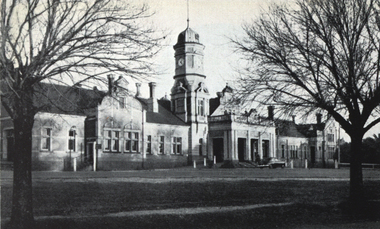
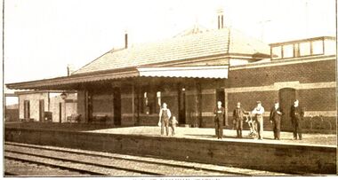
Photograph - Image, Maryborough Railway Station, c1951
Maryborough Railway Station was built in Victoria's heyday of railway planning. A black and white photograph of Maryborough Railway Stationmaryborough railway station, maryborough, architecture -
 Whitehorse Historical Society Inc.
Photograph, Mitcham Railway Station
Mitcham Railway Station to be built underground during 2013.Coloured photograph of the Mitcham Railway Station. This platform is used by passengers heading south towards Ringwood, Lilydale, Belgrave etc. In 2013, the station was rebuilt underground.mitcham railway station, trains, railways -
 Sunbury Family History and Heritage Society Inc.
Photograph, Elwyn Davis, Pedestrian Bridge, C1990s
The wooden pedestrian bridge spanned the rail tracks at Sunbury Railway Station and were replaced with a more modern bridge and ramp when upgrades were done at the station and along the Bendigo line in the late 1990s and early 2000s. The water tank beyond the station building was used to refill the engines with water when steam engines were used. Diesel driven V Line trains now convey commuters from the regional towns along the Bendigo region to Melbourne.The Bendigo Line was the first government rail line to open and it reached Sunbury in 1859. It was extended to Bendigo and opened in 1861.A non-digital coloured photograph of a wooden pedestrian bridge spanning rail tracks with a wooden station building and former water tower on the station platform. rail bridges, bendigo rail line, sunbury station, water towers, railways -
 Stawell Historical Society Inc
Photograph, Railway Station Stawell -- 2 photos-- Coloured
Two colour photos of Stawell Railway Station from different angles.Two (2) Colour Photographs of Stawell Station from across the tracks, from two angles Showin the platform and the top story in the middle of the Station.stawell railways transport -
Glenelg Shire Council Cultural Collection
Photograph - Photograph - Portland railway Station, Victoria, n.d
Black and white photo. Portland railway station, taken from railway tracks. Gordon Hotel can be seen in backgroundBack: 'Portland Railway Station' - handwritten in black pen. Round purple stamp 'PRINTED BY M.E. ANDREWS PORTLAND' -
 Rutherglen Historical Society
Image, W. H. Skey, 1938 (Exact)
Black and white photograph of Old Fire Station during the ceremonial laying of the Foundation Stone for the Rutherglen Bush Nursing Hospital.On back of photo: "The Old Fire Station next library" Also rubber stamp: "Printed by W.H. Skey, Rutherglen"hospital, fire station, foundation stone -
 Federation University Historical Collection
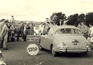
Photograph - Photograph - Black and White, Ballarat School of Mines Students at the R.A.A.F. Station, 1961, 1961
The RAAF retained the Ballarat airfield as its Radio School until 1961. The then-Shire of Ballarat negotiated with the Department of Interior to become the civil operator of the airfield and sought the maintenance on site of the hangars and other structures, however a majority of the P Huts were sold by the Commonwealth. (Wikipedia) Sir William Hudson was a New Zealand-born engineer who headed construction of the Snowy Mountains Scheme for hydroelectricity and irrigation in Australia from 1949 to 1967, when he reluctantly retired at 71. The scheme was completed in 1974, under budget and before time. (Wikipedia)A car with the registration plates HFP949 is stopped by a number of male students from the Ballarat School of Mines. It is a reception for Sir William Hudson at the RAAF station (Ballarat airport). Verso: R.A.A.F. Station 1961. See Magazine Reception for Sir William Hudson Visit. ballarat school of mines, raaf, ballarat airport, students, william hudson, sir william hudson, raaf bas, student activity -
 Orbost & District Historical Society
Book, The Iron Horse Stopped at Orbost Railway Station, 2019
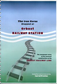
Carrol Preston has used newspaper references from 1877 through to 1917, to document the history of the Orbost - Bairnsdael railway line.. It starts with the lobbying and jockeying, and moves through to the opening in 1916. The title is a reference to plans to further extend the railway beyond Orbost - but "The Iron Horse stopped at Orbost Railway Station". Most articles are from the Snowy River Mail and Bairnsdale Advertiser. All newspaper articles are dated and sourced. About 1912 work began at Newmerella on clearing the track for the railway line from Bairnsdale to Orbost. A canvas town sprang up on the higher land adjacent to the river flats. Local farmers supplied meat, milk and fresh produce to the camp, as well as gaining employment carting and labouring. The line opened in 1916, the Orbost railway station being built on the Newmerella side of the river.This item is associated with the history of the Orbost-Bairnsdale railway line and therefore reflects the role that the rail line played in the social and economic history of Orbost. On April 10 1916, the first scheduled train service left Orbost for Bairnsdale. The Bairnsdale-Orbost railway was opened to serve the agricultural and timber industries. This book has been compiled by a local historian. A spiral bound book titled, "The Iron Horse Stopped at Orbost Railway Station". The cover is blue / green with the title in black and red print. Underneath is a railway track leading to the bottom of the page. The book is 110 pages, A4 size and contains maps and photos. in black print on cover - "The Iron Horse Stopped at Orbost Railway Station ; The newspaper story of the eventual construction of the ORBOST RAILWAY LINE (in red print); Compiled and produced by CARROL PRESTON (in white print)railway-transport orbost-bairnsdale-railway east-gippsland-railway -
 Kew Historical Society Inc
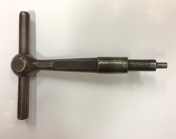
Equipment, Victorian Railways, 'A' Pattern Annett Key : Kew Railway Station, 20th Century
Kew Railway Station was the second railway station on the Kew 'Spur' Line in Melbourne. The key unlocked signals equipment at the Station. The key was donated by Harry Jackson in 2019 during an exhibition at the Kew Court House on railway history in Kew.This piece of railway equipment is a rare oiece of railway memorabilia.'A' pattern Annett Key, used at the Kew Railway Station with signals equipment.KEWkew railway station - denmark street - kew (vic), annett keys -
 Port Fairy Historical Society Museum and Archives
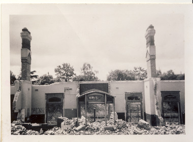
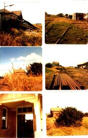
Photograph - Photographic montage
6 photographs of railway station in ruins before removal from siteDocuments the neglect of the railway station in the late 1970’s before the removal of the equipment and buildings6 coloured photographs in collage of dilapidated station transport, rail, road, derelict, railway, station -
 Puffing Billy Railway
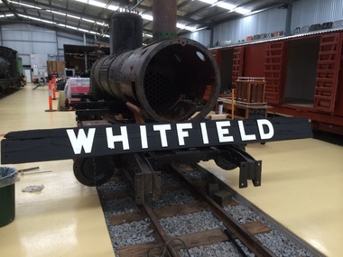
Station Sign, whitfeild Station sign
Historic - Victorian Railways Station sign used at Whitfield Station Whitfield Station The terminus of the line. Whitfield was the most distant narrow gauge station from Melbourne Opened 1899 Closed 1953 Whitfield was the small terminus for the Whitfield railway line The station had a moderately long passenger platform, small goods yard, goods shed, ticket office and locomotive shed. Platforms 1 Tracks 3 Historic - Victorian Railways Station sign used at Whitfield StationStation Sign - Whitfield large black wooden backing board with white letteringWhitfieldpuffing billy, victorian railways, station sign, whitfield -
 Port Fairy Historical Society Museum and Archives
Photograph
Koroit Railway Station closed in 1975 when the rail to Port Fairy was also closed. Unlike the Port Fairy Station the Koroit Station has been restored and is used by local groups and is of course part of the Rail trail from Port Fairy to WarrnamboolBlack and white photograph of Koroit railway station with 6males and a child on platformtransport, rail, road, koroit, railway station -
 Ballarat Heritage Services
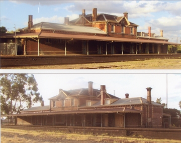
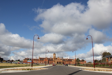
Photograph - Photograph - Colour, Maryborough Railway Station, 2011, 06/08/2011
Maryborough is a ground level premium station, featuring one side platform. It opened on 7 July 1874 The current station building was erected in 1890, with 25 rooms and a clock tower, of red brick with stucco trimming. It was initially closed on 12 September 1993, then reopened on 25 July 2010 with the reintroduction of V/Line passenger services to the station.Colour photograph of a large red brick railway station at Maryborough. maryborough, maryborough railway station -
 Hume City Civic Collection
Photograph, 21/04/2005
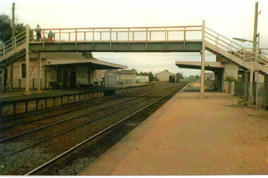
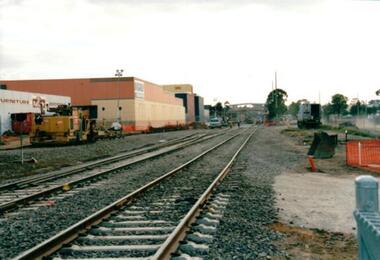
This photograph was taken during the upgrade of the Bendigo Railway line at Sunbury Station. The upgrade took twelve months to complete and during that time bus services replaced the trains.A coloured photograph of construction on the site of the Sunbury Railway Station. The photograph was taken near the Station Street level crossing and is looking north towards the Sunbury Station. The new tracks have been put into place.railways, bendigo line, railway stations, bridges, sunbury railway station, george evans collection -
 National Wool Museum
Newspaper, Stock and Station Journal
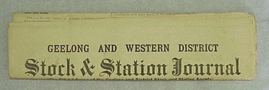
"Stock and Station Journal" newspaper, 2nd July 1951."Stock and Station Journal" newspaper, 2nd July 1951.agriculture - news, geelong and western district stock and station journal, woods, mr george -
 Ballarat Heritage Services
Photograph - Digital photographs, Koroit Railway Station Goods Shed and Siding, 2016
Once a major junction station between the Port Fairy Line and the branch to Penshurst and Hamilton, the track at Koroit has long been removed. The station has been preserved with heritage funding keeping it looking close to its working condition. The large brick station building, platform and goods shed have all been retained and provide a good example of a major junction station on a former railway line.Digital images of remnant railway items at the former Koroit Railway Station. transport, rail trail, koroit, koroit railway station, goods shed, siding -
 Puffing Billy Railway
Station Sign - Fielder
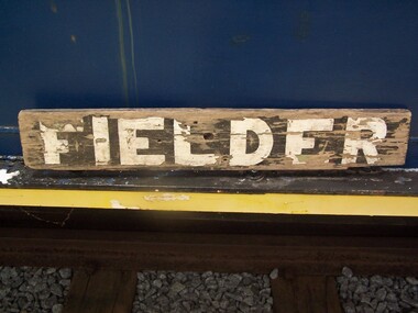
Station Sign - Fielder Fielder Station is situated on the Puffing Billy Railway in Australia. It opened as a Stopping Place on Monday 10 September 1928, as part of the Gembrook railway line. It was originally an unnamed platform, with time tables noting a station at 38 miles (61 km). In 1929, local Harry Watson constructed a Mallee shed and unofficially named it Ancaster after his home town in Lincolnshire, England, but this was quickly changed by some children to Laura, who was a young local girl. The Victorian Railways officially named it Fielder from Tuesday 5 February 1929, after a nearby resident. It was planned to name the station after the two local residents Cullen and Fielder and combinations of the two names were suggested, however Fielder was the name finally chosen. It remained nothing more than a Mallee shed with small office and a name board for the rest of its operating life. It was closed with the line on 30 April 1954 and the Mallee shed was sold to US Buslines for unknown use. After closure, the site fell into disrepair, and by the 1990s, little trace of Fielder remained. However, by that time, efforts were being made to extend the railway from Lakeside through to Gembrook, which would complete the entire length of the original line. In 1996, a group of volunteers led by Richard Schurmann in collaboration with the descendants of the Fielder family rebuilt the platform and waiting shed, which was officially re-opened on Saturday 19 April 1997 in preparation for the extension of the line which re-opened in 1998. On 18 November 2012 a plaque was unveiled on the station shed in tribute to the Fielder Family Trains do not normally stop at Fielder ref: https://en.wikipedia.org/wiki/Fielder_railway_station photos at http://www.vicrailstations.com/Gembrook/Fielder/Fielder.htmlHistoric - Station sign used at Fielder StationStation Sign - Fielder wooden rectangle Station name sign pained black background with white lettersFielderpuffing billy, station sign, fielder station -
 Stawell Historical Society Inc
Photograph, Railway Station Stawell Looking Across the Tracks
Two colour photographs Stawell Railway Station when used as Bus Station Feb 1995B/W Photograph of the Stawell Railway Station Looking acroos the tracks at the Platformstawell railways transport -
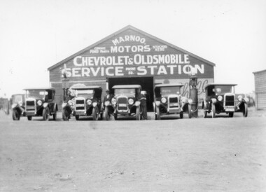 Stawell Historical Society Inc
Photograph, Marnoo Motors Service Station for Chevrolet and Oldsmobile c1920
Marnoo Motors Chevrolet and Oldsmobile Service Station c 1920 with line-up of 1920s Chevrolet's and hand fuel pumps. Black and white photograph of a garage with five motor vehicles in a row, also a petrol pump.Marnoo Motors Chevrolet & Oldsmobile Service Stationvehicles transport business -
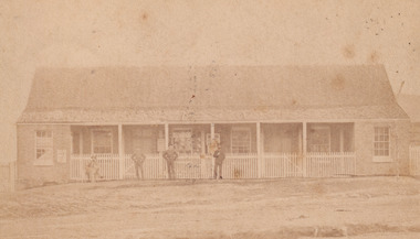 The Beechworth Burke Museum
Photograph - Carte de Visite, William E Barnes
In July of 1880, Ann Jones' successful hotel in Glenrowan burnt to the ground during the Kelly siege. She had opened her business in the year prior having been unsuccessful in her attempt to run a tea-room business in Wangaratta. The first building on this particular site was the home Ann Jones had built for herself and her family. Two years later she converted the home and added the hotel to the rear of the structure. One year later it was burnt to the ground. This image depicts the police station in 1882 on what would have been the site of Ann Jones' hotel. This Carte-de-viste (CdV) taken by renowned Wangaratta based photographer William Edward Barnes previously belonged to the donor's grandfather, Daniel Mullins who was a Police Officer stationed at Glenrowan soon after the Kelly gang siege. Today, the siege has become an important part of Australian culture and Ned Kelly and the Kelly Gang (comprising of Ned Kelly, Dan Kelly, Steve Hart and Joe Byrne) has become ingrained in Australian history and mythology. A CdV is a sepia toned photograph mounted on card and is generally of a small size. This particular style was first patented by Andre Adolphe Eugene Disdéri (1819-1889) in 1854. In 1857, the CdV was introduced to England and after photographs of Queen Victoria, Prince Albert and their family were taken using CdV in 1860 the popularity of this method reached a peak.This photograph is part of the Burke Museum "Kelly album" which includes a significant collection of photographs and artefacts connected to Ned Kelly and the Kelly Gang. Ned Kelly and his gang have become ingrained in Australian popular culture and thus many museums, art galleries and private collections house material connected to the Kelly story which allows the events and people to be researched and interpreted. Artefacts and photographs pertaining to the Kelly gang are particularly valuable for Australian museums. This particular photograph is significant for its connection to Wangaratta based photographer William Edward Barnes and to the Glenrowan Siege and Ann Jones' Hotel which burnt down during the siege in June 1880. Taken in 1882, this photograph has the opportunity to provide information about the townscape of Glenrowan shortly after the siege. It also provides important insight into the architecture and layout of the town. To the far right of the image, the photograph depicts the police station which was built on the site of Ann Jones' Hotel which can provide important information for the Kelly story and how the town evolved following 1880. It is also interesting to emphasise that the police station was built on the site of Ned Kelly and the Kelly gang's last stand.Sepia coloured photograph with a faded appearance. Image depicts four policemen with three standing and one sitting on a chair outside the Glenrowan police station. The station takes up the majority of the image and is placed in the centre of the photo. The four men are positioned on the left side of the station. The station is a large building with a gabled roof and extensions built into the veranda on either side. In between these extensions, the property has a white picket fence which runs from the extensions directly beneath the veranda enclosing the front of the structure. The letters 1, 2, 3, 4 are written on the yellow paper on which the image is situated and relate to the images in the photo. The reverse of the photo provides the names of each policeman and reveals the image as being from the collection of William E Barnes a Wangaratta based photographer.Obverse: 1. 2. 3. 4. Reverse: No. 1. is Mullins, D. G. / 2. Lord, Edward. / 3. Millar, Allex. / 4. Hedberg, O. G. / All Comrades / Glenrowan Police Station / 1 August 1882 / W. E. Barnes / Photographer / Wangaratta /kelly album, william barnes, wangaratta photographer, carte-de-viste, glenrowan, 1882, police station, ann jones inn, ann jones hotel, kelly siege, glenrowan siege, colonial australia, ned kelly, steve hart, joe byrne, william e barnes