Showing 9541 items matching " street names"
-
 Glen Eira Historical Society
Document - Goe, Field Flowers, Bishop
... Flowers and Goe Street names off Bambra Road, South of Glenhuntly...). Field Flowers and Goe Street names off Bambra Road, South ...Three items about this Bishop of Melbourne and his connection to Caulfield: An article taken from Australian Dictionary of Biography v.9 1891-1939 on Field Flowers Goe (1832-1910). Field Flowers and Goe Street names off Bambra Road, South of Glenhuntly Road. Handwritten document researched by M. Dunbar 12/03/2013 taken from Sand, Swamp and Heath.goe field flowers, priest, caulfield historical society, field street, flowers street, goe street, bambra road, glenhuntly road, sand swamp and heath, goe emma, rodgers emma, anglican church -
Glen Eira Historical Society
Document - REGENT STREET, 73, ELSTERNWICK
... of the street name; possibly was Ebden Street. Accompanying... of the street name; possibly was Ebden Street. Accompanying ...Two items about this property 1/typed copy of a list of occupiers at 73 Regent Street, Elsternwick, with some history of the street name; possibly was Ebden Street. Accompanying are handwritten working notes listing residents 1888 – 1974 2/handwritten file note of research from 1903 Sands and McDougall Directory indicating that Regent Street was previously Ebden Street; by GEHS volunteer AK.regent street, elsternwick, wigley arthur l., elston emma, o’brien william, mcconchie robert w., arnott john, davis george, payne charles, arnott arthur j., stewart peter, hart herbert d., clark george, martel kath, mcdevitt charles, mcmurrich r.t., wollaston m.f. mrs, mcinerney d.o., breen g.p. mrs, brown w.l., cox w.h., bullock hilary, landells rosalind, ebden street, ebden charles hotson -
Whitehorse Historical Society Inc.
Map, City of Nunawading, n.d
... Map of the City of Nunawading with streets and railway... stations named Map of the City of Nunawading with streets ...Map of the City of Nunawading with streets and railway stations namedMap of the City of Nunawading with streets and railway stations named Scale 1 mile = 3.75 inMap of the City of Nunawading with streets and railway stations named city of nunawading, maps -
 Ringwood and District Historical Society
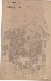
Map, Borough of Ringwood, Victoria - c.1950s
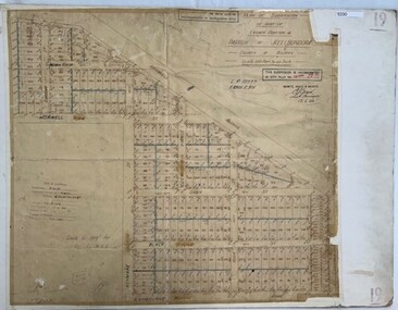
... map of named streets and lot-numbered properties within... of named streets and lot-numbered properties within Borough ...A0-size (approx) linen-backed municipal engineer’s survey map of named streets and lot-numbered properties within Borough of Ringwood.Scale: 8 chains to 1 inch. -
 Kew Historical Society Inc
Plan - Subdivision Plan, J R Mathers & McMillan, Normanby Estate, c.1913
... , Kew East, included thirty-one lots for sale. Streets... is interesting as it shows Wharton Street, named after the architect ...The Kew Historical Society's map collection includes a substantial number of real estate subdivision plans, mainly of Kew but also of surrounding suburbs in Melbourne. Most of the subdivision plans date from the 1920s and 1930s when the districts old homes and local farmland were being split up to accommodate residential growth in the postwar period. These early plans were assembled by a local firm, Jas R Mather & McMillan, which had an office in Cotham Road. Many of the plans, and sometimes photos, were annotated by the agents.Subdivision plans are historically important documents used as evidence for the growth of suburbs in Australia. They frequently provide information about when the land was sold as well as evidence relating to surveyors and real estate and financial agents. The numerous subdivision plans in the Kew Historical Society's collection represent working documents, ranging from the initial sketches made in planning a subdivision to printed plans on which auctioneers or agents listed the prices for which individual lots were sold. In a number of cases, the reverse of a subdivision plan in the collection includes a photograph of a house that was also for sale by the agent. These photographs provide significant heritage information relating house design and decoration, fencing and household gardens.The photograph may also be aesthetically significant depending on the importance of the photographic atelier.The Normanby Estate, which was adjacent to Normanby Road, Kew East, included thirty-one lots for sale. Streets on the subdivision plan include Adeney Avenue, Park Hill Road, Normanby Road, Weir Street and Wharton Street. Cotham Road and its tramway are shown nearby. The plan is interesting as it shows Wharton Street, named after the architect and town planner George Wharton, who was the first chairman of the Municipality of Kew. The street was to later be renamed Cecil Street. Also shown are proposed ‘Municipal Gardens’ where Parkhill Drive is now located."D" in top left corner. Stamped auctioneers contact details: "Jas. R. Mathers & Son & McMillan / Auctioneer & Land Salesmen, / 271 Collins Street / Melbourne" and Jas. R. Mathers / Estate & Financial Agent / Cotham Road / Kew".weir street - kew, wharton street - kew, normanby road - kew, cotham road - kew, municipal gardens - kew, park hill parkhill road - kew, braemar - kew, subdivision plans - kew -
 Kew Historical Society Inc
Plan - Subdivision Plan, Normanby Estate, East Kew, 1913
... , Kew East, included thirty-one lots for sale. Streets.... The plan is interesting as it shows Wharton Street, named after ...Pru Sanderson, in her groundbreaking ‘City of Kew Urban Conservation Study : Volume 2 - Development History’ (1988), summarised the periods of urban development and subdivisions of land in Kew. The periods that she identified included 1845-1880, 1880-1893, 1893-1921, 1921-1933, 1933-1943, and Post-War Development. These periods were selected as they represented periods of rapid growth or decline in urban development. An obvious starting point for Sanderson’s groupings involved population growth and the associated economic cycles. These cycles also highlighted urban expansion onto land that was predominantly rural, although in other cases it represented the decline and breakup of large estates. A number of the plans in the Kew Historical Society’s collection can also be found in other collections, such as those of the State Library of Victoria and the Boroondara Library Service. A number are however unique to the collection.The Kew Historical Society collection includes almost 100 subdivision plans pertaining to suburbs of the City of Melbourne. Most of these are of Kew, Kew East or Studley Park, although a smaller number are plans of Camberwell, Deepdene, Balwyn and Hawthorn. It is believed that the majority of the plans were gifted to the Society by persons connected with the real estate firm - J. R. Mathers and McMillan, 136 Cotham Road, Kew. The Plans in the collection are rarely in pristine form, being working plans on which the agent would write notes and record lots sold and the prices of these. The subdivision plans are historically significant examples of the growth of urban Melbourne from the beginning of the 20th Century up until the 1980s. A number of the plans are double-sided and often include a photograph on the reverse. The Normanby Estate, which was adjacent to Normanby Road, Kew East, included thirty-one lots for sale. Streets on the subdivision plan include Adeney Avenue, Park Hill Road, Normanby Road, Weir Street and Wharton Street. Cotham Road and its tramway are shown nearby. The plan is interesting as it shows Wharton Street, named after the architect and town planner George Wharton, who was the first chairman of the Municipality of Kew. The street was to later be renamed Cecil Street. Also shown are proposed ‘Municipal Gardens’ where Parkhill Drive is now located.subdivision plans - kew, normanby estate -
Surrey Hills Historical Society Collection
Folder of real estate advertisements, Folders of real estate advertisements (Streets beginning with I-J), Various
... . Folders are ordered by street name and then chronologically.... Folders are ordered by street name and then chronologically ...A4 folders with individual pockets for each property in streets beginning with I-J located in Surrey Hills and Mont Albert. Folders are ordered by street name and then chronologically by property number. Each property has its own pocket. This may include multiple real estate advertisements collected from sales over time. It may also include copies of any research undertaken by Alan Holt and / or members of the SHNCHC team. These are augmented by cards in the Alan Holt index file and by his property registers of Surrey Hills and Mont Albert.inglisby road, james street, junction road -
Surrey Hills Historical Society Collection
Folder of real estate advertisements, Folders of real estate advertisements (Streets beginning with Q-R), Various
... . Folders are ordered by street name and then chronologically... by street name and then chronologically by property number. Each ...A4 folders with individual pockets for each property in streets beginning with Q-R located in Surrey Hills and Mont Albert. Folders are ordered by street name and then chronologically by property number. Each property has its own pocket. This may include multiple real estate advertisements collected from sales over time. It may also include copies of any research undertaken by Alan Holt and / or members of the SHNCHC team. These are augmented by cards in the Alan Holt index file and by his property registers of Surrey Hills and Mont Albert.queen street, redvers street, riversdale road, robinson road, rose avenue, ross street, rostrevor parade, rowland street, royal lane, russell street -
Surrey Hills Historical Society Collection
Folder of real estate advertisements, Folders of real estate advertisements (Streets beginning with X-Z), Various
... . Folders are ordered by street name and then chronologically... by street name and then chronologically by property number. Each ...A4 folders with individual pockets for each property in streets beginning with X-Z located in Surrey Hills and Mont Albert. Folders are ordered by street name and then chronologically by property number. Each property has its own pocket. This may include multiple real estate advertisements collected from sales over time. It may also include copies of any research undertaken by Alan Holt and / or members of the SHNCHC team. These are augmented by cards in the Alan Holt index file and by his property registers of Surrey Hills and Mont Albert.york street, zetland road -
 Bendigo Historical Society Inc.
Photograph - WES HARRY COLLECTION: TOWNSHIP OF SANDHURST, 1854
... streets are named)... Inc. History House 11 Mackenzie Street Bendigo goldfields ...Photograph of the Parish Plan of the Township of Sandhurst in 1854. It covers the area of the CBD from Mitchell (not named) to Bernal Streets and from the Bendigo Creek to Mollison St. ( other than Pall Mall and McRae streets, none of these parallel streets are named)place, bendigo, first survey, sandhurst, first survey, bendigo creek -
 Greensborough Historical Society
Map, Melbourne and Metropolitan Board of Works. Survey Division, MMBW, Yarra 2500 / 12.24. Plenty and Blue Lake, 1977_10
... Valley 257. Shows street names, easement sizes, lot numbers... of Whittlesea 239 and Diamond Valley 257. Shows street names, easement ...Melbourne and Metropolitan Board of Works. Yarra 2500 [base map]. 12-24, Municipalities of Whittlesea 239 and Diamond Valley 257. Shows street names, easement sizes, lot numbers, lodged plan numbers, names of prominent features, contour values, creek or river names. Watsonia Railway Station and environs. Prominent streets: Memorial Drive. Includes Plenty River and Blue Lake in the Plenty Gorge.MMBW Map in 1:2500 [scale] series. Cream parchment with green tape reinforcing on edges and punched holes on left edge.mmbw, melbourne and metropolitan board of works, shire of diamond valley, plenty - maps, blue lake -
 Greensborough Historical Society
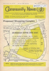
Newsletter, Greenhills and North Greensborough Progress Association, Community News: official journal of the Greenhills and Nth. Greensborough Progress Association and the Apollo Parkways Progress Association. 4th April, 1977. Edition No. 3/77, 04/04/1977
... ; Apollo Parkways street names, Kinder news. A digital copy...; Apollo Parkways street names, Kinder news. A digital copy ...Proposed shopping complex: Greensborough shopping centre debate, Information or consultation - which? The Greensborough shopping centre... two way communication, I remember when, Meet the natives, Diamond Valley Civic Centre Library, This and that, Local fauna controversy, Women's recreation, From the Council Chamber; Apollo Parkways street names, Kinder news. A digital copy of this Newsletter is available from Greensborough Historical Society. Newsletter, 20 p., illus.greenhills and north greensborough progress association, greenhills, apollo parkways progress association, apollo parkways -
 Phillip Island and District Historical Society Inc.
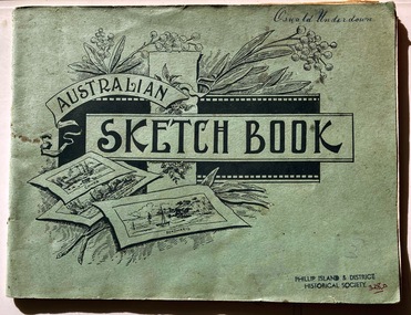
Booklet, Australian Sketch Book of pressed flowers
... , possibly in the 1890s. They lived in Reid Street, Rhyll. Name... Street, Rhyll. Name of donor is Ossie or Oswald Underdown ...The Underdown family were early settlers on the Island, possibly in the 1890s. They lived in Reid Street, Rhyll. Name of donor is Ossie or Oswald Underdown.HistoricalLarge pale green sketch book with blank pages covered in native wildflower specimens and each page covered with transparent paper. a few pages of sketches at back of book. Completed in 1912Australian Sketch Bookdrawing book, wildflower collection, native flowers, oswald underdown -
 Phillip Island and District Historical Society Inc.
Booklet, Australian Sketch Book of drawings by Ossie Underdown
... , possibly in the 1890s. They lived in Reid Street, Rhyll. Name... Street, Rhyll. Name of donor is Ossie or Oswald Underdown ...The Underdown family were early settlers on the Island, possibly in the 1890s. They lived in Reid Street, Rhyll. Name of donor is Ossie or Oswald Underdown.HistoricalLarge, pale green sketch book with scale and freehand drawings of plants, flowers. Completed in 1912Australian Sketch Book. Oswald Underdown.drawing, oswald underdown, drawing book -
 Warrnambool and District Historical Society Inc.
Book, New Testament The Queens Jubilee 1887, 1886
... on the origin of street names in Warrnambool. Allendale is a small... Street (south of Merri St) Warrnambool great-ocean-road This book ...This book was printed to commemorate Queen Victoria’s Jubilee, 1887 (50th anniversary of her Coronation as Queen of England). John Markman is most likely the father or grandfather of Mary Snell (nee Markman). Mrs Snell was a teacher in Warrnambool and an active member of the Warrnambool and District Historical Society in its early years. She wrote the first book on the origin of street names in Warrnambool. Allendale is a small settlement in the Hepburn area of Victoria. This book is of minor interest as a memento of Queen Victoria’s 1887 Jubilee and as a book that appears to have come to the Historical Society via an early member, Mary Snell (nee Markman). This is a book of 240 pages. It has a black cover with the imprint on the front cover of a crown and shield and the words ‘The Queen’s Jubilee, 1887, Victoria’ and on the back cover a circular scroll with the words, ‘British and Foreign Bible Society, New Testament’. The cover has been bound with black tape and adhesive tape but the binding has come apart. Several pages are torn at the edges and dog-eared. ‘John Markman, Allendale, 17th June 1887’ Copy of Queen Victoria’s handwritten message - ‘On earth peace, goodwill toward men, Victoria, Windsor Castle, March 8,1887’ john markman, mary snell, history of warrnambool. -
 Greensborough Historical Society
Map, Melbourne and Metropolitan Board of Works. Survey Division, MMBW, Yarra 2500 / 13.21. Central Greensborough, 1979_05
... , Municipality of Diamond Valley 257. Shows street names, easement sizes.... Shows street names, easement sizes, lot numbers, lodged plan ...Melbourne and Metropolitan Board of Works. Yarra 2500 [base map]. 13-21, Parishes of Keelbundora 2856 and Nillumbik 3310, Municipality of Diamond Valley 257. Shows street names, easement sizes, lot numbers, lodged plan numbers, names of prominent features, contour values, creek or river names. Central Greensborough. Prominent streets: Main Street, Para Road, St Helena Road and Diamond Creek Road.MMBW Map in 1:2500 [scale] series. Cream parchment with green tape reinforcing on edges and punched holes on left edge.mmbw, melbourne and metropolitan board of works, shire of diamond valley, greensborough - maps -
 Greensborough Historical Society
Map, Melbourne and Metropolitan Board of Works. Survey Division, MMBW, Yarra 2500 / 12.19. Watsonia, Simpson Army Barracks, 1983_03
... of Diamond Valley 257 and 228. Shows street names, easement sizes..., Municipalities of Diamond Valley 257 and 228. Shows street names ...Melbourne and Metropolitan Board of Works. Yarra 2500 [base map]. 12-19, Parish of Keelbundora 2856, Municipalities of Diamond Valley 257 and 228. Shows street names, easement sizes, lot numbers, lodged plan numbers, names of prominent features, contour values, creek or river names. Watsonia Barracks (Simpson Army Barracks) and environs. Prominent streets: Yallambie Road, Greensborough Road, and Strathallan Road. MMBW Map in 1:2500 [scale] series. Cream parchment with green tape reinforcing on edges and punched holes on left edge.mmbw, melbourne and metropolitan board of works, shire of diamond valley, watsonia - maps -
Glen Eira Historical Society
Letter - MEMORIES GLEN EIRA ROAD
... /Handwritten research by Claire Barton on street names and residents... Barton on street names and residents off Orrong Road in 1911 ...2 items: 1/A ten page handwritten letter from Mrs. C.R. Biesse on 12/12/1976 to Mr. Murray. The letter gives her memories of the area around Judge Hood’s Estate, related to her by an elderly acquaintance and her grandfather. Includes a small handdrawn map. 2/Handwritten research by Claire Barton on street names and residents off Orrong Road in 1911 Sands and McDougall directory.biesse c.r. mrs., merton street, caulfiled north, judge hood, hood crescent, droving, judge hood’s estate, land subdivision, judge stephens, st. mary’s church, otira road, helenslea road, shelford, landscapes, kerr b. mrs., palmer florence mrs., morrice street, glen eira road, kambea grove, bushland, cattle, mitchell mr. builder, palmer florence, mitchell colin, mitchell clive, mitchell francis, mitchell mrs., perry family, orrong road, st. aubins ave., ‘orotava’, hayes g.h., ‘kambea’, lothian henry, oswald j.d., ‘merton’, glen eira road -
 Greensborough Historical Society
Poster - Planning Document, City of Heidelberg, Subdivision Plan # 19 - Parish of Keelbundoora, Crown Portion 16, Watsonia "Black's subdivision', 1924
... includes proposed street names which were later changed (e.g... includes proposed street names which were later changed (e.g ...Subdivision Plan # 19 - Parish of Keelbundoora, Crown Portion 16, Watsonia "Black's subdivision". This subdivision plan includes proposed street names which were later changed (e.g. Morwell Street (not Morwell Avenue) now called Greenwood Drive). Includes Lambourn Road, Black Street, Grace Street, Eden Avenue, High Street, Kenmare Street, Morwell Avenue, Greensborough Road, Mundy Street, Ladd Street.An example of hard copy subdivision plans from the Greensborough area. Mainly from the Shire of Diamond Valley era (1964-1994).Plan (single sided) mounted on heavy card. Stamped and handwritten Council permissions, dates and other details. subdivision plans, city of heidelberg, greensborough, main street greensborough, shire of heidelberg, watsonia, black family -
 Ballarat Tramway Museum
Map - "Geelong tramways", Ken McCarthy, 1981
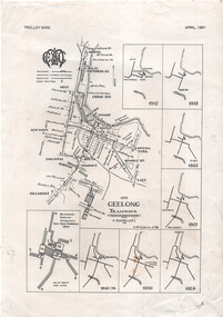
... . 1981 showing the Geelong tram system with major street names.... 1981 showing the Geelong tram system with major street names ...Map titled "Geelong tramways" prepared by Ken McCarthy Feb. 1981 showing the Geelong tram system with major street names, with a service frequency chart for weekdays in 1951 and 7 small maps showing the various stages of system development from 1912 to 1940. Has an insert for the depot layout. Produced for Ken's article on Geelong Tramways in the April 1981 issue of Trolley Wire, published by the Sydney Tram Museum.Yields information about the Geelong tram system and has a close association with Ken McCarthy.A4 printed sheet - from the April 1981 issue of Trolley Wire magazine.tramways, geelong, map, trolley wire -
 Ringwood and District Historical Society
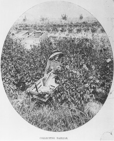
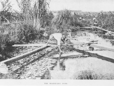
Photograph, Collecting Dahlias - Mr. Hill's Flower Farm - Mt. Dandenong Rd, Ringwood 1905
... flower farm, subdivided, name retained in street name. Miss Elvie.... Later Howship's flower farm, subdivided, name retained in street ...Black and white photograph (4 copies)Typed note at bottom of one photograph- "Mr. Hill's Flower Farm - Mt. Dandenong Rd. Miss Hill collecting dahlias. 1905." Typed note on back of separate photograph- "John Hill's flower farm 29/3/05, Mt Dandenong Rd, Ringwood East. Later Howship's flower farm, subdivided, name retained in street name. Miss Elvie Hill. -
 Wodonga & District Historical Society Inc
Photograph - Mann Collection Album - Old Police Station and Courthouse, C1964
... . This is reflected in the street name. The Court House was destroyed by fire... police station, built in 1900. It was built on High Street, next ...Elaine Mann was married to David Mann, a successful Wodonga businessman and community leader who passed away in Wodonga in June 2012. David was a member of the Mann family who began their business in Wodonga in 1920. Elaine was a teacher in Wodonga for many years and an active member of the community.This photo collection is of significance as it documents how the businesses and buildings in Wodonga have evolved and contributed to community throughout the late 20th century.This was Wodonga's second police station, built in 1900. It was built on High Street, next to Bond Street. The Court House can be seen in the background. The building was formerly used as a custom-house or bond store where people paid import duties on goods coming into Victoria from other states, including N.S.W. This is reflected in the street name. The Court House was destroyed by fire in 1964. This police station was in use until a move was made into a new police station in Elgin Street (next to Elgins Hotel) in December 1967. This area is now part of the newly developed Junction Place Precinct.high st wodonga, woldonga police station, wodonga court house, bond store -
Federation University Historical Collection
Plan, University of Ballarat Camp Street Precinct, 2000, c2000
... The university aspect of the Camp Street Precinct was named... The university aspect of the Camp Street Precinct was named the arts ...The university aspect of the Camp Street Precinct was named the arts AcademyFramed plans of the Univesity of Ballarat (later Federation University) Camp Street Precinct. .1) Drawing of elevations for the university of Ballarat and the City of Ballarat Camp Street Precinct elevations including a new performing arts Building, Mining Exchange, Visual Arts Building, and Alfred Deakin Place. .2) Camp Street Precinct elevations including the Ballarat Post Office, State Offices and Old Courthouse. camp street, camp street precinct, plans, daryl jackson, arts academy -
 Warrnambool and District Historical Society Inc.
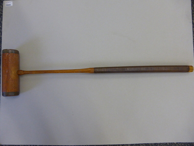
Mallet, Croquet Mallet, Late 19th century/early 20th century
... Street named ‘Heatherlie’ (the site of the current retirement... of 50. She lived at the house at 113 Koroit Street named ...This croquet mallet belonged to Martha Beatrice McCullough (nee Barker), wife of George McCullough, who died in November 1931 at the age of 50. She lived at the house at 113 Koroit Street named ‘Heatherlie’ (the site of the current retirement residential units) and owned and managed the Silver Stream Café in Liebig Street. The mallet was used by her and may have been used by her mother before her. Croquet was a popular sport, especially for women after the 1880s. This is a significant item as it is an artefact associated with women’s sport in the late 19th century and early 20th century. It is also important as it belonged to a local Warrnambool resident and businesswoman whose granddaughter resides in Warrnambool today.This is a brown-coloured wooden croquet mallet. The handle has ribbed leather binding and the mallet has brass edging and brass on the under section attached with twelve brass screws. The handle is octagonal shaped. The lower section of the handle and the mallet have been varnished. On the mallet: ‘The Reel’croquet, warrnambool -
 Phillip Island and District Historical Society Inc.
Photograph, Underdown home in Rhyll, About 1900
... , possibly in the 1890s. They lived in Reid Street, Rhyll. Name... Street, Rhyll. Name of donor was Ossie or Oswald Underdown ...The Underdown family were early settlers on the Island, possibly in the 1890s. They lived in Reid Street, Rhyll. Name of donor was Ossie or Oswald Underdown.[Source Cherry McFee]Faded black & white photo on cardboard mount of a man, believed to be Mr Underdown, standing in front of a house with a dog and horse.Underdown property in Rhyll. Later Strawberry Gardens.underdown family, rhyll, buildings - historical, historic homes, local identities, oswald underdown, photographs -
 Ringwood and District Historical Society
Photograph, The Water-Lily Pond at Hill's Flower Farm, Ringwood, in 1905, 1905
... flower farm subdivided, name retained in street name. Pool... in street name. Pool was part of Sandy Gully Creek 1905. Black ...Black and white photograph (2 copies)Typed under photograph: The Water Lily Pond. Mr Hill's flower farm, Mt Dandenong Rd. Later Howship's. In area around Howship Street. Written on back of one image: 'Australasian' 29/3/05. John Hill's flower farm, Mt Dandenong Rd. Later Howship's flower farm subdivided, name retained in street name. Pool was part of Sandy Gully Creek 1905.water lillies, flower farming -
 Greensborough Historical Society
Map, Melbourne and Metropolitan Board of Works. Survey Division, MMBW, Yarra 2500 / 12.20. Watsonia Railway Station and environs, 1983_03
... of Diamond Valley 257 and 228. Shows street names, easement sizes... street names, easement sizes, lot numbers, lodged plan numbers ...Melbourne and Metropolitan Board of Works. Yarra 2500 [base map]. 12-20, Parishes of Keelbundora 2856, Municipalities of Diamond Valley 257 and 228. Shows street names, easement sizes, lot numbers, lodged plan numbers, names of prominent features, contour values, creek or river names. Watsonia Railway Station and environs. Prominent streets: Watsonia Road, Elder Street, Morwell Avenue and Nepean Street. Includes former Watsonia Technical School and Gresswell Rehabilitation Centre sites.MMBW Map in 1:2500 [scale] series. Cream parchment with green tape reinforcing on edges and punched holes on left edge.mmbw, melbourne and metropolitan board of works, shire of diamond valley, watsonia - maps -
 Greensborough Historical Society
Map, Melbourne and Metropolitan Board of Works. Survey Division, MMBW, Yarra 2500 / 12.21. Watsonia North, 1979_02
... of Diamond Valley 257. Shows street names, easement sizes, lot..., Municipality of Diamond Valley 257. Shows street names, easement sizes ...Melbourne and Metropolitan Board of Works. Yarra 2500 [base map]. 12-22, Parish of Keelbundora 2856, Municipality of Diamond Valley 257. Shows street names, easement sizes, lot numbers, lodged plan numbers, names of prominent features, contour values, creek or river names. Watsonia Railway Station and environs. Prominent streets: Grimshaw Street, William Street and Macorna Street. Includes former Institute of Social Welfare (now Loyola College) Lines Reserve and Binnak Park.MMBW Map in 1:2500 [scale] series. Cream parchment with green tape reinforcing on edges and punched holes on left edge.mmbw, melbourne and metropolitan board of works, shire of diamond valley, watsonia - maps, bundoora - maps -
 Bendigo Historical Society Inc.
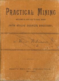
Book - PRACTICAL MINING, 1894
... & McCutcheon, 516 Little Collins Street Melbourne, name written inside... Inc. History House 11 Mackenzie Street Bendigo goldfields ...Practical Mining arithmetic applied to mine work (with miners business directory) by Wm.Wilson. Printed by Mason,Firth & McCutcheon, 516 Little Collins Street Melbourne, name written inside Geo.Fooke Bendigo. pockat formatted book with tan cloth hard cover 165 pages.Wm.Wilsonbooks, technical, mining -
Port Melbourne Historical & Preservation Society
Photograph - Swallow & Ariell biscuit factory after conversion to apartments, Peter Libbis, 9 Aug 1997
... after conversion to apartments, Rouse and Princes Streets. 1997... Melbourne Town Hall 333 Bay Street Port Melbourne melbourne built ...Colour photograph of Swallow & Ariell's biscuit factory after conversion to apartments, Rouse and Princes Streets. 1997. Original name, date of establishment and manufacture are shown in this shot.built environment - industrial, built environment - domestic, swallow & ariell ltd