Showing 256 items
matching the state rivers and water supply commission
-
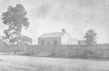
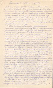
 The Beechworth Burke Museum
Photograph, Unknown c.1930s
... . The State Rivers and Water Supply Commission of Victoria and the New.... The State Rivers and Water Supply Commission of Victoria and the New ...This image shows Bethanga Bridge, which was constructed between 1927 and 1930 in Albury, NSW. The bridge was a necessity due to the building of the Hume Dam (Wier), 1919-1936. Bethanga Bridge is a long, nine-span, riveted-steel, variable depth, Pratt Truss road bridge of nine principal spans of 82 metres and a total length of 752 metres over the flooded valley of the Murray River, now part of Hume Reservoir. Because of its unique location, over the waters of a dam with the border running down the centre of the body of water, the Bethanga bridge is the only built structure shared by both New South Wales and Victoria. It was built 1.6 kilometres upstream of the dam and in 1961 was raised 300mm, with a concrete deck replacing the original wooden deck. The State Rivers and Water Supply Commission of Victoria and the New South Wales Department of Public Works were responsible for the construction works for the Hume Weir under the River Murray Waters Agreement. It is apparent that a similar joint arrangement was made for the construction of the Bethanga Bridge as part of the Hume Weir works.This photograph of the Bethanga Bridge is of historical significance as it showcases the architectural skills of Percy Allen and Vincent Packer. Additionally, it reveals the environmental landscape of the 1920s-1930s, is linked to the Hume Dam and both New South Wales and Victorian heritage. Unmounted black and white rectangular photograph. Reverse: 1997.3196 84-20-3bethanga, bethanga bridge, hume dam, pratt truss, murray river, hume weir, transportation -
 Bendigo Historical Society Inc.
Map - Laminated map of Lake Eppalock at full capacity. Map 'E'
... by the State Rivers and Water Supply Commission of Victoria. The dam.... The dam was built by the State Rivers and Water Supply Commission ...John Perry Collection. Laminated map of Lake Eppalock at full capacity. Black and white. The dam was built by the State Rivers and Water Supply Commission of Victoria. The dam wall height is 45 metres (148 ft) and the main embankment is 1,041 metres (3,415 ft) long. At 100% capacity the dam wall was designed to hold back 304,651 megalitres (6.7014×10¹⁰ imp gal; 8.0480×10¹⁰ US gal) of water. The surface area of Lake Eppalock is 3,011 hectares (7,440 acres) and the catchment area is 2,124 square kilometres (820 sq mi). The controlled spillway is capable of discharging 8,040 cubic metres per second (284,000 cu ft/s). Lake Eppalock supplies both stock and domestic water to the Campaspe irrigation district. It also serves as a water supply to Bendigo and Heathcote and, in more recent times, Ballarat. The lake is a major attraction for those engaging in watersports, with a number of tourist parks and accommodation facilities available. Permissible activities on the lake include high-speed boating, water skiing, sailing, canoeing, fishing and swimming. The lake's water levels were low for approximately eight years between 2002 and 2010 during a prolonged drought, which restricted the amount of recreational activity until rainfall in the latter half of 2010 returned the lake to 100 percent capacity. Built between 1961 and 1964, Lake Eppalock remains the only water storage on the Campaspe River system.map, eppalock, water, dam, reservoir -
Bendigo Historical Society Inc.
Map - Black and white map pertaining to Lake Eppalock
... . The dam was built by the State Rivers and Water Supply Commission... Rivers and Water Supply Commission of Victoria. The dam wall ...John Perry Collection. Laminated copy of map relating to Lake Eppalock. Lists dwellings, ford crossings and bridges. The dam was built by the State Rivers and Water Supply Commission of Victoria. The dam wall height is 45 metres (148 ft) and the main embankment is 1,041 metres (3,415 ft) long. At 100% capacity the dam wall was designed to hold back 304,651 megalitres (6.7014×10¹⁰ imp gal; 8.0480×10¹⁰ US gal) of water. The surface area of Lake Eppalock is 3,011 hectares (7,440 acres) and the catchment area is 2,124 square kilometres (820 sq mi). The controlled spillway is capable of discharging 8,040 cubic metres per second (284,000 cu ft/s). Lake Eppalock supplies both stock and domestic water to the Campaspe irrigation district. It also serves as a water supply to Bendigo and Heathcote and, in more recent times, Ballarat. The lake is a major attraction for those engaging in watersports, with a number of tourist parks and accommodation facilities available. Permissible activities on the lake include high-speed boating, water skiing, sailing, canoeing, fishing and swimming. The lake's water levels were low for approximately eight years between 2002 and 2010 during a prolonged drought, which restricted the amount of recreational activity until rainfall in the latter half of 2010 returned the lake to 100 percent capacity. Built between 1961 and 1964, Lake Eppalock remains the only water storage on the Campaspe River system.map, water, dam, reservoir, eppalock -
Bendigo Historical Society Inc.
Map - Black and white map pertaining to Lake Eppalock
... crossings. The dam was built by the State Rivers and Water Supply... by the State Rivers and Water Supply Commission of Victoria. The dam ...John Perry Collection. Laminated copy of map pertaining to Lake Eppalock. Gives details of dwellings, bridges and ford crossings. The dam was built by the State Rivers and Water Supply Commission of Victoria. The dam wall height is 45 metres (148 ft) and the main embankment is 1,041 metres (3,415 ft) long. At 100% capacity the dam wall was designed to hold back 304,651 megalitres (6.7014×10¹⁰ imp gal; 8.0480×10¹⁰ US gal) of water. The surface area of Lake Eppalock is 3,011 hectares (7,440 acres) and the catchment area is 2,124 square kilometres (820 sq mi). The controlled spillway is capable of discharging 8,040 cubic metres per second (284,000 cu ft/s). Lake Eppalock supplies both stock and domestic water to the Campaspe irrigation district. It also serves as a water supply to Bendigo and Heathcote and, in more recent times, Ballarat. The lake is a major attraction for those engaging in watersports, with a number of tourist parks and accommodation facilities available. Permissible activities on the lake include high-speed boating, water skiing, sailing, canoeing, fishing and swimming. The lake's water levels were low for approximately eight years between 2002 and 2010 during a prolonged drought, which restricted the amount of recreational activity until rainfall in the latter half of 2010 returned the lake to 100 percent capacity. Built between 1961 and 1964, Lake Eppalock remains the only water storage on the Campaspe River system.eppalock, map, water, dam, reservoir -
Bendigo Historical Society Inc.
Document - Legend to maps A, B and C for Lake Eppalock
... and Water Supply Commission of Victoria. The dam wall height is 45... Rivers and Water Supply Commission of Victoria. The dam wall ...John Perry Collection. Laminated 'legend' for Maps A, B and C for Lake Eppalock also in this collection. Black and White definitions and descriptions of objects and markers found on maps. Circa 1951. The dam was built by the State Rivers and Water Supply Commission of Victoria. The dam wall height is 45 metres (148 ft) and the main embankment is 1,041 metres (3,415 ft) long. At 100% capacity the dam wall was designed to hold back 304,651 megalitres (6.7014×10¹⁰ imp gal; 8.0480×10¹⁰ US gal) of water. The surface area of Lake Eppalock is 3,011 hectares (7,440 acres) and the catchment area is 2,124 square kilometres (820 sq mi). The controlled spillway is capable of discharging 8,040 cubic metres per second (284,000 cu ft/s). Lake Eppalock supplies both stock and domestic water to the Campaspe irrigation district. It also serves as a water supply to Bendigo and Heathcote and, in more recent times, Ballarat. The lake is a major attraction for those engaging in watersports, with a number of tourist parks and accommodation facilities available. Permissible activities on the lake include high-speed boating, water skiing, sailing, canoeing, fishing and swimming. The lake's water levels were low for approximately eight years between 2002 and 2010 during a prolonged drought, which restricted the amount of recreational activity until rainfall in the latter half of 2010 returned the lake to 100 percent capacity. Built between 1961 and 1964, Lake Eppalock remains the only water storage on the Campaspe River system.map, water, dam, reservoir, eppalock -
Bendigo Historical Society Inc.
Map - Map of overlay of lake Eppalock at full capacity. Map 'C'
... was built by the State Rivers and Water Supply Commission... and Water Supply Commission of Victoria. The dam wall height is 45 ...John Perry collection. Map 'C'. Laminated map of overlay of Lake Eppalock at full capacity. Circa 1951. The dam was built by the State Rivers and Water Supply Commission of Victoria. The dam wall height is 45 metres (148 ft) and the main embankment is 1,041 metres (3,415 ft) long. At 100% capacity the dam wall was designed to hold back 304,651 megalitres (6.7014×10¹⁰ imp gal; 8.0480×10¹⁰ US gal) of water. The surface area of Lake Eppalock is 3,011 hectares (7,440 acres) and the catchment area is 2,124 square kilometres (820 sq mi). The controlled spillway is capable of discharging 8,040 cubic metres per second (284,000 cu ft/s). Lake Eppalock supplies both stock and domestic water to the Campaspe irrigation district. It also serves as a water supply to Bendigo and Heathcote and, in more recent times, Ballarat. The lake is a major attraction for those engaging in watersports, with a number of tourist parks and accommodation facilities available. Permissible activities on the lake include high-speed boating, water skiing, sailing, canoeing, fishing and swimming. The lake's water levels were low for approximately eight years between 2002 and 2010 during a prolonged drought, which restricted the amount of recreational activity until rainfall in the latter half of 2010 returned the lake to 100 percent capacity. Built between 1961 and 1964, Lake Eppalock remains the only water storage on the Campaspe River system.map, water, eppalock, dam, reservoir -
Bendigo Historical Society Inc.
Map - Laminated map of Lake Eppalock empty. Map 'D'
... Rivers and Water Supply Commission of Victoria. The dam wall... was built by the State Rivers and Water Supply Commission ...John Perry Collection. Laminated map of Lake Eppalock empty. Map 'D'. Circa 1951. The dam was built by the State Rivers and Water Supply Commission of Victoria. The dam wall height is 45 metres (148 ft) and the main embankment is 1,041 metres (3,415 ft) long. At 100% capacity the dam wall was designed to hold back 304,651 megalitres (6.7014×10¹⁰ imp gal; 8.0480×10¹⁰ US gal) of water. The surface area of Lake Eppalock is 3,011 hectares (7,440 acres) and the catchment area is 2,124 square kilometres (820 sq mi). The controlled spillway is capable of discharging 8,040 cubic metres per second (284,000 cu ft/s). Lake Eppalock supplies both stock and domestic water to the Campaspe irrigation district. It also serves as a water supply to Bendigo and Heathcote and, in more recent times, Ballarat. The lake is a major attraction for those engaging in watersports, with a number of tourist parks and accommodation facilities available. Permissible activities on the lake include high-speed boating, water skiing, sailing, canoeing, fishing and swimming. The lake's water levels were low for approximately eight years between 2002 and 2010 during a prolonged drought, which restricted the amount of recreational activity until rainfall in the latter half of 2010 returned the lake to 100 percent capacity. Built between 1961 and 1964, Lake Eppalock remains the only water storage on the Campaspe River system.map, water, dam, reservoir, eppalock -
Bendigo Historical Society Inc.
Document - Collection of photographs from newspaper on a single page
... . The dam was built by the State Rivers and Water Supply Commission... Rivers and Water Supply Commission of Victoria. The dam wall ...John Perry Collection. Laminated copy of page from 'Weekly Times' newspaper, February, 1962. Nine images relating to establishing and building Eppalock Reservoir, 15 miles from Bendigo. The dam was built by the State Rivers and Water Supply Commission of Victoria. The dam wall height is 45 metres (148 ft) and the main embankment is 1,041 metres (3,415 ft) long. At 100% capacity the dam wall was designed to hold back 304,651 megalitres (6.7014×10¹⁰ imp gal; 8.0480×10¹⁰ US gal) of water. The surface area of Lake Eppalock is 3,011 hectares (7,440 acres) and the catchment area is 2,124 square kilometres (820 sq mi). The controlled spillway is capable of discharging 8,040 cubic metres per second (284,000 cu ft/s). Lake Eppalock supplies both stock and domestic water to the Campaspe irrigation district. It also serves as a water supply to Bendigo and Heathcote and, in more recent times, Ballarat. The lake is a major attraction for those engaging in watersports, with a number of tourist parks and accommodation facilities available. Permissible activities on the lake include high-speed boating, water skiing, sailing, canoeing, fishing and swimming. The lake's water levels were low for approximately eight years between 2002 and 2010 during a prolonged drought, which restricted the amount of recreational activity until rainfall in the latter half of 2010 returned the lake to 100 percent capacity. Built between 1961 and 1964, Lake Eppalock remains the only water storage on the Campaspe River system. dam, engineering, water, eppalock -
Bendigo Historical Society Inc.
Map - Laminated map of Lake Eppalock at full capacity
... Rivers and Water Supply Commission of Victoria. The dam wall.... The dam was built by the State Rivers and Water Supply Commission ...John Perry Collection. Laminated copy of map of Lake Eppalock at full capacity. Had highlighter markings of old roads which appear to be still in use. The dam was built by the State Rivers and Water Supply Commission of Victoria. The dam wall height is 45 metres (148 ft) and the main embankment is 1,041 metres (3,415 ft) long. At 100% capacity the dam wall was designed to hold back 304,651 megalitres (6.7014×10¹⁰ imp gal; 8.0480×10¹⁰ US gal) of water. The surface area of Lake Eppalock is 3,011 hectares (7,440 acres) and the catchment area is 2,124 square kilometres (820 sq mi). The controlled spillway is capable of discharging 8,040 cubic metres per second (284,000 cu ft/s). Lake Eppalock supplies both stock and domestic water to the Campaspe irrigation district. It also serves as a water supply to Bendigo and Heathcote and, in more recent times, Ballarat. The lake is a major attraction for those engaging in watersports, with a number of tourist parks and accommodation facilities available. Permissible activities on the lake include high-speed boating, water skiing, sailing, canoeing, fishing and swimming. The lake's water levels were low for approximately eight years between 2002 and 2010 during a prolonged drought, which restricted the amount of recreational activity until rainfall in the latter half of 2010 returned the lake to 100 percent capacity. Built between 1961 and 1964, Lake Eppalock remains the only water storage on the Campaspe River system.map, water, dam, reservoir, eppalock -
Bendigo Historical Society Inc.
Map - Black and White map. Outline of Lake Eppalock. Map 'B'
... 1951. The dam was built by the State Rivers and Water Supply... by the State Rivers and Water Supply Commission of Victoria. The dam ...John Perry Collection. Laminated copy black and white map. Map 'B'. Outline of Lake Eppalcok, overlayed on map. Circa 1951. The dam was built by the State Rivers and Water Supply Commission of Victoria. The dam wall height is 45 metres (148 ft) and the main embankment is 1,041 metres (3,415 ft) long. At 100% capacity the dam wall was designed to hold back 304,651 megalitres (6.7014×10¹⁰ imp gal; 8.0480×10¹⁰ US gal) of water. The surface area of Lake Eppalock is 3,011 hectares (7,440 acres) and the catchment area is 2,124 square kilometres (820 sq mi). The controlled spillway is capable of discharging 8,040 cubic metres per second (284,000 cu ft/s). Lake Eppalock supplies both stock and domestic water to the Campaspe irrigation district. It also serves as a water supply to Bendigo and Heathcote and, in more recent times, Ballarat. The lake is a major attraction for those engaging in watersports, with a number of tourist parks and accommodation facilities available. Permissible activities on the lake include high-speed boating, water skiing, sailing, canoeing, fishing and swimming. The lake's water levels were low for approximately eight years between 2002 and 2010 during a prolonged drought, which restricted the amount of recreational activity until rainfall in the latter half of 2010 returned the lake to 100 percent capacity. Built between 1961 and 1964, Lake Eppalock remains the only water storage on the Campaspe River system.map, water, dam, reservoir, eppalock -
Bendigo Historical Society Inc.
Map - General view of area of proposed construction of Lake Eppalock. Map 'A'
... and Water Supply Commission of Victoria. The dam wall height is 45... by the State Rivers and Water Supply Commission of Victoria. The dam ...John Perry Collection. Laminated map of proposed construction of Lake Eppalock. Map 'A'. Black and white map in laminate. Circa 1951. The dam was built by the State Rivers and Water Supply Commission of Victoria. The dam wall height is 45 metres (148 ft) and the main embankment is 1,041 metres (3,415 ft) long. At 100% capacity the dam wall was designed to hold back 304,651 megalitres (6.7014×10¹⁰ imp gal; 8.0480×10¹⁰ US gal) of water. The surface area of Lake Eppalock is 3,011 hectares (7,440 acres) and the catchment area is 2,124 square kilometres (820 sq mi). The controlled spillway is capable of discharging 8,040 cubic metres per second (284,000 cu ft/s). Lake Eppalock supplies both stock and domestic water to the Campaspe irrigation district. It also serves as a water supply to Bendigo and Heathcote and, in more recent times, Ballarat. The lake is a major attraction for those engaging in watersports, with a number of tourist parks and accommodation facilities available. Permissible activities on the lake include high-speed boating, water skiing, sailing, canoeing, fishing and swimming. The lake's water levels were low for approximately eight years between 2002 and 2010 during a prolonged drought, which restricted the amount of recreational activity until rainfall in the latter half of 2010 returned the lake to 100 percent capacity. Built between 1961 and 1964, Lake Eppalock remains the only water storage on the Campaspe River system.map, dam, water, weir, eppalock -
Bendigo Historical Society Inc.
Map - Laminated worksheet - identification of inundated artifacts at Lake Eppalock
... . The dam was built by the State Rivers and Water Supply Commission... Rivers and Water Supply Commission of Victoria. The dam wall ...John Perry Collection. Laminated copy of worksheet identifying inundated artifacts at Lake Eppalock when at 10% capacity. The dam was built by the State Rivers and Water Supply Commission of Victoria. The dam wall height is 45 metres (148 ft) and the main embankment is 1,041 metres (3,415 ft) long. At 100% capacity the dam wall was designed to hold back 304,651 megalitres (6.7014×10¹⁰ imp gal; 8.0480×10¹⁰ US gal) of water. The surface area of Lake Eppalock is 3,011 hectares (7,440 acres) and the catchment area is 2,124 square kilometres (820 sq mi). The controlled spillway is capable of discharging 8,040 cubic metres per second (284,000 cu ft/s). Lake Eppalock supplies both stock and domestic water to the Campaspe irrigation district. It also serves as a water supply to Bendigo and Heathcote and, in more recent times, Ballarat. The lake is a major attraction for those engaging in watersports, with a number of tourist parks and accommodation facilities available. Permissible activities on the lake include high-speed boating, water skiing, sailing, canoeing, fishing and swimming. The lake's water levels were low for approximately eight years between 2002 and 2010 during a prolonged drought, which restricted the amount of recreational activity until rainfall in the latter half of 2010 returned the lake to 100 percent capacity. Built between 1961 and 1964, Lake Eppalock remains the only water storage on the Campaspe River system.map, artifacts, eppalock, reservoir -
 Ringwood and District Historical Society
Photograph, The Lewis Findlay East Residence, Bedford Rd, Ringwood. 1901
... of the State Rivers and Water Supply Commission in 1936, and received... of the State Rivers and Water Supply Commission in 1936, and received ...Black and white photograph of weatherboard house surrounded by a picket fence. (2 copies- 1 large, 1 small). Typed notes detailing history of cottage.Typed notes contain the following: "Cottage and Lot 15, Sec.C, Township of Ringwood - comprising 1 acre - were acquired from the Crown by John Price on 17th July, 1888, for £30. Subsequently, a 4-roomed weatherboard cottage was built on Lot 15. On 21st May, 1901, the two allotments and the house were transferred to Lewis Findlay East for £85, and on 13th March, 1942, were sold to R. Barr and L. Beaumont for £650 with two additional rooms and some other improvements including reticulated water supply. Lewis Findlay EAST and his family occupied the cottage until 1910. It is believed that before the cottage was purchased by East, it was occupied for a period by McCubbin the artist. Lewis Findlay East was a member of an Australian Rifle Team which went to Bisley, England, in 1901, and won the Kalapore Cup. He was an officer of the Department of Customs, and later became Secretary of the Commonwealth Marine Branch, receiving the I.S.O. His son, Lewis Ronald East, became Chairman of the State Rivers and Water Supply Commission in 1936, and received C.B.E.". -
Bendigo Historical Society Inc.
Document - Directions to Lake Eppalock with road descriptions and map
... Rivers and Water Supply Commission of Victoria. The dam wall... was built by the State Rivers and Water Supply Commission ...John Perry Collection. Laminated copy of 'Directions to Lake Eppalock'. Gives directions in relationship of Lake Eppalock to Bendigo, Kyneton and Heathcote. Undated. Gives basic descriptions of bridges on lakebed, ford crossings on lakebed and inundated dwellings on lakebed. The dam was built by the State Rivers and Water Supply Commission of Victoria. The dam wall height is 45 metres (148 ft) and the main embankment is 1,041 metres (3,415 ft) long. At 100% capacity the dam wall was designed to hold back 304,651 megalitres (6.7014×10¹⁰ imp gal; 8.0480×10¹⁰ US gal) of water. The surface area of Lake Eppalock is 3,011 hectares (7,440 acres) and the catchment area is 2,124 square kilometres (820 sq mi). The controlled spillway is capable of discharging 8,040 cubic metres per second (284,000 cu ft/s). Lake Eppalock supplies both stock and domestic water to the Campaspe irrigation district. It also serves as a water supply to Bendigo and Heathcote and, in more recent times, Ballarat. The lake is a major attraction for those engaging in watersports, with a number of tourist parks and accommodation facilities available. Permissible activities on the lake include high-speed boating, water skiing, sailing, canoeing, fishing and swimming. The lake's water levels were low for approximately eight years between 2002 and 2010 during a prolonged drought, which restricted the amount of recreational activity until rainfall in the latter half of 2010 returned the lake to 100 percent capacity. Built between 1961 and 1964, Lake Eppalock remains the only water storage on the Campaspe River system.water, dam, directions, eppalock -
Bendigo Historical Society Inc.
Map - Map of Lake Eppalock shoreline when empty
... was built by the State Rivers and Water Supply Commission... and Water Supply Commission of Victoria. The dam wall height is 45 ...John Perry Collection. Laminated copy of map detailing Lake Eppalock shoreline when empty. Circa 1951. Has colored highlighter lines following roads leading to lake shoreline and various inundated old roads and tracks on lakebed. The dam was built by the State Rivers and Water Supply Commission of Victoria. The dam wall height is 45 metres (148 ft) and the main embankment is 1,041 metres (3,415 ft) long. At 100% capacity the dam wall was designed to hold back 304,651 megalitres (6.7014×10¹⁰ imp gal; 8.0480×10¹⁰ US gal) of water. The surface area of Lake Eppalock is 3,011 hectares (7,440 acres) and the catchment area is 2,124 square kilometres (820 sq mi). The controlled spillway is capable of discharging 8,040 cubic metres per second (284,000 cu ft/s). Lake Eppalock supplies both stock and domestic water to the Campaspe irrigation district. It also serves as a water supply to Bendigo and Heathcote and, in more recent times, Ballarat. The lake is a major attraction for those engaging in watersports, with a number of tourist parks and accommodation facilities available. Permissible activities on the lake include high-speed boating, water skiing, sailing, canoeing, fishing and swimming. The lake's water levels were low for approximately eight years between 2002 and 2010 during a prolonged drought, which restricted the amount of recreational activity until rainfall in the latter half of 2010 returned the lake to 100 percent capacity. Built between 1961 and 1964, Lake Eppalock remains the only water storage on the Campaspe River system.map, eppalock, reservoir, lake, water -
Bendigo Historical Society Inc.
Document - Black and white laminated photo of flow of water from Lake Eppalock. 1964
... by the State Rivers and Water Supply Commission of Victoria. The dam... and Water Supply Commission of Victoria. The dam wall height is 45 ...John Perry Collection. Laminated copy of photo of crowd watching flow of water from the opened valve at the wall of Lake Eppalock during its commissioning. March, 1964. Lake Eppalock was created by flooding to town of Wild Duck. The dam was built by the State Rivers and Water Supply Commission of Victoria. The dam wall height is 45 metres (148 ft) and the main embankment is 1,041 metres (3,415 ft) long. At 100% capacity the dam wall was designed to hold back 304,651 megalitres (6.7014×10¹⁰ imp gal; 8.0480×10¹⁰ US gal) of water. The surface area of Lake Eppalock is 3,011 hectares (7,440 acres) and the catchment area is 2,124 square kilometres (820 sq mi). The controlled spillway is capable of discharging 8,040 cubic metres per second (284,000 cu ft/s). Lake Eppalock supplies both stock and domestic water to the Campaspe irrigation district. It also serves as a water supply to Bendigo and Heathcote and, in more recent times, Ballarat. The lake is a major attraction for those engaging in watersports, with a number of tourist parks and accommodation facilities available. Permissible activities on the lake include high-speed boating, water skiing, sailing, canoeing, fishing and swimming. The lake's water levels were low for approximately eight years between 2002 and 2010 during a prolonged drought, which restricted the amount of recreational activity until rainfall in the latter half of 2010 returned the lake to 100 percent capacity. Built between 1961 and 1964, Lake Eppalock remains the only water storage on the Campaspe River system.water, dam, reservoir, eppalock, wild duck -
 Wodonga & District Historical Society Inc
Album - Hume Reservoir Australia Album - Detail plan and explanation, Department of Public Works, N.S.W, 1927
... and Water Supply Commission of Victoria who are the Constructing... and Water Supply Commission of Victoria who are the Constructing ...This set of photos is from a leather bound album bearing the inscription "HUME RESERVOIR AUSTRALIA" plus 'The Rt. Hon. L. C. M. S. Amery, P. C., M .P.' all inscribed in gold. It was presented to The Rt. Hon. L. C. M. S. Amery, P. C., M. P, Secretary of State for Dominion Affairs on the occasion of his visit to the Hume Reservoir on 2nd November 1927. This album is of local and national significance as it documents the planning and development of the Hume Reservoir up to 1927. It was the largest water reservoir in the British Empire. The album records the pioneering engineering work that went into its construction.2. Detail Plan and Section. Starting from the New South Wales and there will be an earthen embankment 430 feet 6 inches long which is retained by the North Wing Wall. Then come the sluice section 284 feet 3 inches long, the spillway 720 feet long and the South Wing Wall, making a total length of 1,042 feet 6 inches of concrete wall. Beyond the South Wing Wall is earth embankment again to a length of 3,827 feet. The Full Supply Level is R.L.626.00 and allowance has been made for a surcharge of 9 feet. A road will run along the top of the dam at R.L.642.00. The sluice section contains seven offlets, the three nearest the north wing wall being 13 feet in diameter for hydro-electric purposes and the other four 9 feet in diameter for regulation purposes only. There are to be stony sluice gates on the upstream ends of the outlets and needle valves on the downstream ends. The shock of the discharged water will be taken by a stilling pool. Trash racks will protect the intake ends of the outlets. Next comes the spillway section, which is curved on the downstream face, and carried up to within 15 feet of the full supply level. Above that will be a series of piers between which will be the flood gates and on top of which the roadway will be carried. The gates will be 20 feet wide and 15 feet high and will be 29 in number. They will slide down the face of the wall when opened for the escape of the water. The investigation of the control of this cascade of water was made by means of a model and as a result the form of “bucket” or energy dissipater shown on the section of the spillway was decided upon. The earth embankment in Victoria is being constructed by the State Rivers and Water Supply Commission of Victoria who are the Constructing Authority for that State under the River Murray Waters Agreement. The core of the embankment is of concrete 6 feet wide at the base tapering to 2 feet at the top end and is reinforced with steel rods from the level of the decomposed rock upwards. On the downstream side, at about natural surface level, is a tunnel for drainage and inspection purposes. Above the tunnel is a vertical layer of large stones to drain any seepage to the tunnel. Against the core wall is packed selected material of as impervious a character as can be got locally and beyond that the bank is carefully built up in horizontal layers by means of horses and wheel scoops. The upstream slope is 3-to-1 hardening to 2½-to-1 at the top and the downstream slope is 2½-to-1 hardening to 2.07-to-1 at the top. The thrust of the upstream toe is taken by a mass of granite blocks, and this face is protected by concrete laid in situ. The width of the bank at base is 650 feet and at top 32 feet.hume reservoir australia, river murray waters scheme, hume weir diagrams, hume plan details -
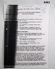 Bendigo Military Museum
Administrative record - Use of Military maps for water supply planning, 1962
... State Rivers and Water Supply Commission... Rivers and Water Supply Commission 5 x A4 pages of typed notes ...These are typed notes on the use of Military maps for water supply planning. This demonstrates the value of Military Mapping containing accurate relief information that can then be used for water supply planning.5 x A4 pages of typed notes, poorly photocopiedroyal australian survey corps, rasvy, fortuna, army survey regiment, army svy regt, asr, state rivers and water supply commission -
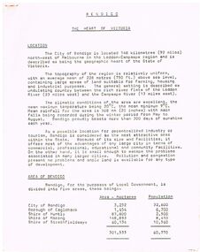 Bendigo Historical Society Inc.
Document - BENDIGO - THE HEART OF VICTORIA
... State Rivers & Water Supply Commission... Commission Gas & Fuel Corporation of Victoria State Rivers & Water ...Typed article titled Bendigo, The Heart of Victoria. Items mentioned are Location, Area of Bendigo, The People, Work Force, Industrial Base, natural Resources, Agriculture and Livestock, Minerals, Forests, Rail and Road, Sea and Air, Power and Water, Electricity, Natural Gas, Water, Sewerage, Industrial Land, Services, Community Services and Facilities, Educational Facilities, Hospitals, Culture and Tourism and Media.document, bendigo - the heart of victoria, city of bendigo, borough of eaglehawk, shire of huntly, shire of marong, shire of strathfieldsaye, bendigo development committee, department of agriculture, department of state development decentralization and tourism, state electricity commission, gas & fuel corporation of victoria, state rivers & water supply commission, bendigo sewerage authority, the bendigo college of advanced education, home and hospital for the aged, home for the blind, northern school of nursing, art gallery, historical society, dudley house, sun loong, central deborah gold mine, the vintage talking trams and transport museum, bcv8, the bendigo advertiser, golden city gazette, 3bo, 3cv, mr a j kelly -
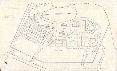 Bendigo Historical Society Inc.
Document - STATE RIVERS AND WATER SUPPLY COMMISSION : EPPALOCK RECREATIONAL AREA PLAN?
... STATE RIVERS AND WATER SUPPLY COMMISSION : EPPALOCK...State Rivers and Water Supply Commission. Coliban System... STATE INFRASTRUCTURE Water supply coliban system State Rivers ...Photocopied plan of power points for a recreational area, possibly Eppalock foreshore recreational area?. No title, and undated. With other Eppalock documents.state infrastructure, water supply, coliban system, state rivers and water supply commission. coliban system. eppalock. -
 Bendigo Historical Society Inc.
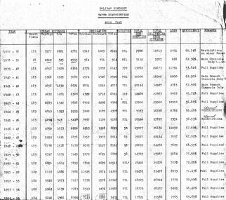
Document - STATE RIVERS AND WATER COMMISSION : COLIBAN DISTRICT WATER DISTRIBUTION ACRE FEET
... State Rivers and Water Supply Commission. Coliban System.... STATE INFRASTRUCTURE Water supply coliban system State Rivers ...A table titled Coliban District Water Distribution Acre Feet. The dates indicated cover the period 1937-1957. Main column headings: Urban Supplies, Irrigation, Sluicing, Total Consumption, Total Deliveries from Storages, Loss, Efficiency, and Remarks. Years and figures are typed in red columns with some figures totalled in pencil at the bottom of the last column.state infrastructure, water supply, coliban system, state rivers and water supply commission. coliban system. -
 Bendigo Historical Society Inc.
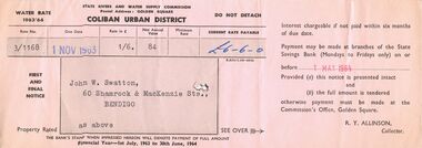
Document - J W SWATTON COLLECTION: STATE RIVERS AND WATER COMMISSION ACCOUNT
... Account issued by State Rivers And Water Supply Commision... ESSENTIAL SERVICES water supply Account issued by State Rivers ...Account issued by State Rivers And Water Supply Commision for water rates 1963/64 addressed to J. W. Swatton 60 Shamrock and MacKenzie Streets, Bendigo.essential services, water supply -
 Bendigo Historical Society Inc.
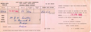
Document - J W SWATTON COLLECTION: WATER RATE NOTICE
... State Rivers & Water Supply Commission... & Water Supply Commission Coliban Urban District R Y Allinson Pink ...Pink Water Rate notice for 1962/63 for property at 60 Shamrock St. Bendigo. Rate for £6/6/0.person, receipts, j w swatton, j w swatton collection, state rivers & water supply commission, coliban urban district, r y allinson -
 Bendigo Historical Society Inc.
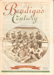
Newspaper - LONG GULLY HISTORY GROUP COLLECTION: BENDIGO'S CENTURY VOLUME FIVE: 1940 - 1949
... State Rivers and Water Supply Commission... Webbo Mervyn Tresize State Rivers and Water Supply Commission ...Newspaper supplement titled Bendigo's Century Volume Five: 1940 - 1949. Each year has heading of Who's Who, Weather, Sport and Business. Front page is titled Bendigo's Century and has a photo of a group of soldiers in uniform and with rifles. They were district servicemen on leave in 1944. Each year has heading of Who's Who, Weather, Sport and Business. First years are 1940 - 1949 titled Bendigo as it was. It has two photos of women wading through the 1949 Pall Mall flood waters and one of Miners in the crib room of the Central Deborah Mine. They are Jackie Lewis, Bob Johnson, W Landy, Ryga Yates and Les Johnson. 1940 - Army moves in to racecourse, 1941 - Devastating fire at pottery, 1942 - Forces expand, 1943 - Nation's eyes on Bendigo, 1944 - News dawns of D-day landing, 1945 - City cheers the end of the war, 1946 - Celebrations begin in city, 1947 - Gallery gets top paintings, 1948 - Water plan looks good and 1949 - Flood takes a toll on city.bendigo, history, long gully history group, the long gully history group - bendigo's century - volume five: 1940 - 1949, bendigo advertiser, central deborah mine, jackie lewis, bob johnson, w landy, ryga yates, les johnson, central nell gwynne, department of defence, bendigo jockey club, 8th division, robert menzies, deborah mine, bendigo decentralisation vigilance committee, cr w h taylor, bendigo war funds organisation, the easter fair society, bendigo agricultural show committee, mr e g ham, mr j v fairbairn, cr a staples, the bendigo chamber of commerce, richard hartley smith abbott, captain harley abbott, bendigo art gallery, bill woodfull, bendigo high school, north deborah mine, boardwalk, toni riley pharmacy, windermere hotel, cr g a pethard, coliban system, north deborah mine, bendigo pottery, bendigo trades hall council, private lawrence burstall, major-general g j rankin mhr, andrew dunstan, ordnance factory, royal australian navy, hmas bendigo, sec offices, muioof, ymca, georger addlem, fred addlem, cr a j anderson, pauline buvhan thompson, leslie thompson, edward joseph leonski, bendigo football league, mr j dedman, william stephens, forest street methodist church, pte charles phillips, pte w e durward, pte t foley, william john stephens, central nell gwynne, air chief marshall sir arthur tedder, cr taylor, united nations, flying officer, r bruce tuff, flight lieutenant owens, royal air force, commonwealth war workers housing trust scheme, mr s mckinnon, bendigo decentralised vigilance committee, ravenswood estate, john lienhop mlc, margaret (peggy) brennan, strathfieldsaye shire council, school of mines, bendigo base hospital, william george ashman, ashman's tailors, bendigo jockey club, victorian football association, bendigo east swimming pool, deborah anticline, specimen hill methodist church, north deborah, adolf hitler, benito mussolini, australian 7th division, cr galvin, bendigo war funds organisation, hmas bendigo, lt-commander jackson, bendigo football league, central deborah mine, victoria day, cr truscott, bendigo gaol, lansellstowe, awas barracks, bendigo citizens committee, john cain snr, ordnance factory, bendigo agricultural society, the duke of gloucester, duchess of gloucester, bendigo tennis association, north deborah, gillies famous pies, aids & appliance shop, mrs georgina scott, dr j a neptune scott, alfred sisley, corot, daubigney, louis sonnenberg, gas employees' union, john lienhop, soldier settlement commission, burnewang estate, king george vi, princess elizabeth, lt philip mountbatten, mr e j w herbert, ansett airways, reg ansett, most rev, dr john mccarthy, dr bernard stewart, michael giudice, bendigo united breweries, bendigo lyric photo plays, bendigo sun newspaper, shamrock hotel, west bendigo progress association, alan mcdonald, south bendigo football club, albert collier, j t webbo, mervyn tresize, state rivers and water supply commission, eppalock reservoir, public works committee, bendigo rotary club, john edgar, bendigo base hospital, albert dunstan, benevolent home, magetti's wine hall, wallace reef wine hall, magetti family, albert magetti, lance galvin, bradford cotton spinnings (victoria) pty otd, arthur syer, stanley crossman, albert arthur dunstan, rev dr henry backhaus, city family hotel, lyric theatre, bank of australasia, city club hotelcolonial mutual building, r matchett & co, lansellstowe, leonard lansell, bendigo bas hospital, australian women's army service, mr hollway, kenworth (aust) ltd, foggitt jones's bacon factory, gordon sayers, sandhurst trustees, dr john drowley, alexander hislop, royal mint, north deborah mine, ironbark south mining company, central nell gwynne company, new chum syncline -
 Bendigo Historical Society Inc.
Document - BENDIGO'S WATER SUPPLY
... State Rivers and Water Supply Commission... State Rivers and Water Supply Commission Lauriston Reservoir ...Handwritten notes titled 'Bendigo's Water Supply'. Notes mention the early water supply for Bendigo, The construction of the reservoirs, some costs, and the dates they were constructed.document, bendigo's water supply, e h emmett, bendigo water works co, no 7 reservoir, law courts, coliban scheme, j f sullivan, the bendigo council, water works, robinson crusoe gully, angus mackay, state rivers and water supply commission, lauriston reservoir, lake eppalock, dates when reservoirs were built, preston vale, bendigo and vicinity -
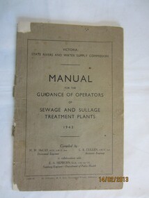 Wannon Water
Manual/book, Government printer, Manual for the guidance of operators of sewage and sullage treatment plants 1943, 1943
... Engineer, Department of Public Health State Rivers and Water Supply ...Compiled by H.W.McCay, Divisional Engineer and L.B.Cullen, Assistant Engineer in collaboration with E.A. Hepburn, Sanitary Engineer, Department of Public HealthState Rivers and Water Supply Commission was the government body responsible for water supply.A booklet, with a front brown cover, back cover missing, 61 pagesHandwritten L Bush on top of first pagewater supply, sewage, wastewater management, operating manuals, water reclamation plant -
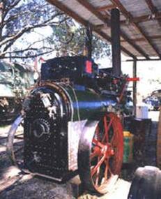 Puffing Billy Railway
Portable Compound Steam Engine, Marshall & Son's - Builders Number 48317, circa 1908 / 1909
... state rivers and water supply commission of victoria... and water supply commission of victoria portable compound engine ...Portable Compound Engine - Marshall & Son's. Builders Number 48317 Built by Marshall Sons & Co., Ltd., Gainsborough, England (Builder’s Number 48317 of approximately 1908/1909), to the order of Robison Brothers, Engineers, South Melbourne. It was used for operating a pump to supply irrigation water at Robinvale in Northern Victoria. Robison Bros & Co. P/L was founded by James McFarlane Robison and his brothers in 1854, initially as plumbers and coppersmiths, the firm expanded into general engineering, boiler-making and brass, iron and steel founders and became one of Melbourne's most important engineering firms. They constructed railway bridges, gold mining equipment, railway locomotives, pumping stations, brewing vessels, abattoir machinery, amongst much else and including the first turnstiles at the Melbourne Cricket Ground. A portable engine is either a steam engine or an internal combustion engine, that remains in one place while operating (providing power to machinery), and can be easily moved from one work site to another. Mounted on wheels or sometimes skids, it is required to be towed between work sites.Historic - Industrial Portable Compound Engine - steam engine - Marshall & Son's. Marshall & Son's Portable Compound Engine - Builders Number 48317 made of steel Marshall & Son's. Builders Number 48317puffing billy, state rivers and water supply commission of victoria, portable compound engine - marshall & son's., portable compound engine, marshall sons & co., ltd., robison bros & co. p/l -
Tatura Irrigation & Wartime Camps Museum
file, State Rivers & Water Supply Commission
... State Rivers & Water Supply Commission..., State Rivers & Water Supply Commission file ...This collection was owned by Keith Daniel, an accountant with SR & WSC. Resident in Tatura 6-7 years until 1965File containing - Victorian Government Gazette March 6, 1968. - - Map, Goulburn Irrigation System - Murchison A, SR & WSC Journal "Aqua" April 1966 , Lake Eppalock Boating Guide, "Aqua Summer 1991, Brochure & newspaper adv. re: Waranga Lakeside estate.1974 -
Tatura Irrigation & Wartime Camps Museum
Sight Glasses, 1920 - 1980
... victoria state rivers and water supply commission... and water supply commission dethridge wheel irrigation A piece ...The wheel meter was enclosed in a solid metal case with a window at the top for reading through. this type of meter worked on the axle of the wheel.A piece of thick glass for covering a dethridge wheel meter(old type). Box of 50 (2 missing)victoria state rivers and water supply commission, dethridge wheel, irrigation -
 Tatura Irrigation & Wartime Camps Museum
Photograph
... Victoria State Rivers and Water Supply Commission... and Water Supply Commission Photograph ...irrigation, deakin, victoria state rivers and water supply commission