Showing 543 items
matching vegetation
-
 Lakes Entrance Regional Historical Society (operating as Lakes Entrance History Centre & Museum)
Postcard, Bulmer H D, 1910c
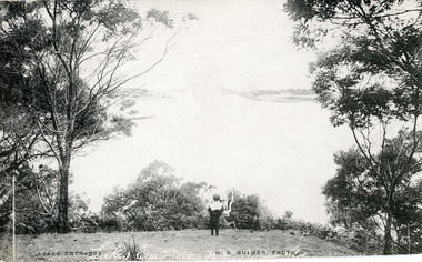
Also black and white enlargement size 16 x 25.| Note on back of postcard, 'Bemm River 16/8/11, To My Dear Elsie, Just a line....., Much love from all, Annie.'Black and white postcard of the man made entrance through the sand hummocks, taken from Jemmys Point. Small boy looking towards entrance, natural vegetation on brow of hill. Lakes Entrance VictoriaLakes Entrancefences, waterways, topography, public works -
 Lakes Entrance Regional Historical Society (operating as Lakes Entrance History Centre & Museum)
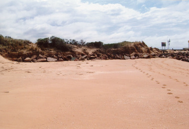
Photograph, 2009
Date made January 2009Colour photograph showing western side of western pier. Rocks extend from end of pier along base of sand dunes, some vegetation on dunes. Signs and lights on piers. Lakes Entrance Victoriajetties, topography, transport -
 Lakes Entrance Regional Historical Society (operating as Lakes Entrance History Centre & Museum)
Photograph, 1992
Also another photograph taken at slightly different angle by Judy Davies 04675.1 10 x 15 cmColour photograph showing the Lady Harriet barge moored on North side of Bullock Island at mouth of North Arm with Kalimna enscarpment in background, some vegetation on Bullock Island on right Lakes Entrance Victoriaboats and boating -
Lakes Entrance Regional Historical Society (operating as Lakes Entrance History Centre & Museum)
Photograph, 1940 c
No 3 in series of fiveBlack and white photograph taken looking back from ocean side showing vegetation in background and workmen with shovels horses and scoops opening an entrance through sand at mouth of Snowy River Marlo Victoriaenvironment, people, public works, waterways -
 Bendigo Historical Society Inc.
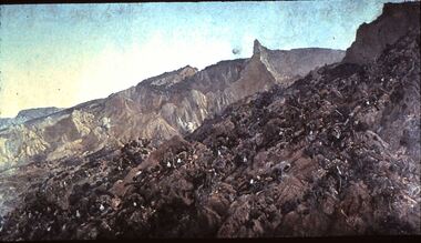
Slide - DIGGERS & MINING: THE DIGGERS, 1903
Diggers & Mining: The Diggers. Image of battle front, Diggers lay dying and dead on hill side. Hillside is very barren of vegetation. Markings: VISAR COPYRIGHT SET - THE DIGGERS, 7. Used as a teaching aid.Visaireducation, tertiary, diggers -
 Beechworth Honey Archive
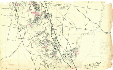
Hand-Drawn Map Centred on Armstrong by Frank Lebbell Frost Dec 1916
This is one of the maps drawn by Frank L. Frost while he was beekeeping in North-East Victoria. This particular map may be reference in the "Wooden" Diary on page 11.Hand-drawn map centred on Armstrong, a town 6 miles from Ararat. Details vegetation along Great Western Highway. Drawn with black pen and grey lead on paper. Features are marked in red.hand drawn, hand-drawn, map, armstrong, ararat, frost, beekeeper, beechworth honey -
 Greensborough Historical Society
Photograph - Digital image, Marilyn Smith, Plenty River bank at Greensborough 2015; Rear of lower Main Street shops, 16/08/2015
Vegetation on the Plenty River embankment in Greensborough. A River bank stabilisation project along the Plenty River at Greensborough was conducted by Melbourne Water in 2015.Digital copy of colour photographplenty river, melbourne water -
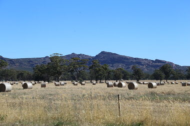 Victorian Farmers Federation
Photograph, Lisa Gervasoni, Hay bales in the Grampians Region, 27/01/2017
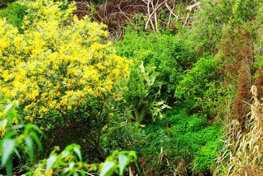
Hay bales are a key food in a grazing livestock production system. The paddock shows the co-existence of native vegetation which provides cover for livestock. Digital photographfarming, hay, native vegetation, agriculture, farm, western victoria -
 Lakes Entrance Regional Historical Society (operating as Lakes Entrance History Centre & Museum)
Photograph, 1930 c
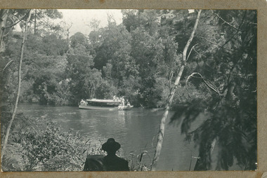
Black and white photograph showing Broomes launch Maranui in Tambo River (?) Thick vegetation on either bank. Several people on boat, one man centre lower edge on the bank watching. Swan Reach VictoriaBroome's Launch (written on back)waterways, boats and boating, tourism -
 Lakes Entrance Regional Historical Society (operating as Lakes Entrance History Centre & Museum)
Photograph, 1920c
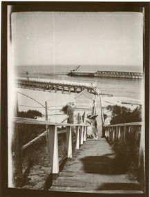
Black and white photograph showing entrance to Gippsland Lakes from ocean Bass Strait. People in 1920s style dress on boardwalk. Kiosk on beach closed. Vegetation either side of boardwalk. Lakes Entrance Victoriajetties, ocean, waterways -
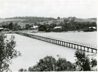 Lakes Entrance Regional Historical Society (operating as Lakes Entrance History Centre & Museum)
Postcard, 1937c
1 copy same|1 copy in poor condition- Mrs Helen Stokes|1 tinted copy. all same sizeBlack and white small format postcard of the footbridge over the Cunninghame Arm. It shows natural vegetation of the south shore in the foreground and residences and trees of the township and Myer Street ascending the hill in the background. Lakes Entrance Victoriawaterways, bridges, township -
Lakes Entrance Regional Historical Society (operating as Lakes Entrance History Centre & Museum)
Photograph, 1950 c
Also a colour photograph of western side of Red Bluff taken by Ian Fraser c 1990 number 03731.3 size 8.5 x 13.5 cmBlack and white photograph showing west side of Red Bluff with sand built up over rocky beach, low vegetation on rocky bluff, two men in swimming trunks on rocks Lake Tyers Victoriatopography, people, clothing -
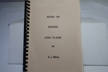 Kiewa Valley Historical Society
Book - Notes on Bogong High Plains by E. J. Minty, Notes on Bogong High Plains by E. J. Minty
The book includes detailed accounts in 4 sections of 1. History and Exploration 2. General Geology 3. Vegetation and slide set index 4. Climate ...Important knowledge/study for the construction of the Kiewa Hydro Electric Scheme on the Bogong High Plains.Cream cardboard cover book with black spiral binding. Title printed in black on cover. 46 pages printed on both sides includes diagrams. Clear blue plastic sheet as last page.e. j. minty, bogong high plains, kiewa hydro electric scheme -
Lakes Entrance Regional Historical Society (operating as Lakes Entrance History Centre & Museum)
Photograph, 1900 c
On baqck of original Raymond Island Tambo River in distance. This survey lookout has been washed away, seawater has killed vegetation and allowed erosionBlack and white photograph of a timber beacon on land in Gippsland Lakes in vacinity of Raymond Island Victoriaboats and boating, competitions, celebrations -
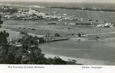 Lakes Entrance Regional Historical Society (operating as Lakes Entrance History Centre & Museum)
Postcard, Bulmer H D, 1935
Marine Parade has not yet been formed through the low lying marshy area adjacent to North Arm. Very little vegetation on Eastern end of hummocks.Black and white postcard of the western end of Lakes Entrance,showing a glimpse of the North Arm bridge, town situated adjacent to Cunninghame Arm, sand hummocks and ocean in distance. Lakes Entrance VictoriaThe Township at Lakes Entrancetownship, waterways, bridges, hotels -
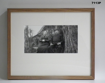 Bendigo Military Museum
Photograph - PHOTOGRAPH - FRAMED WW1, Wayne Eels, C.2008/2009
The Grinton Collection. A French Couple at Home. Refer Cat No. 1280 for Jack Grintons service details.Photograph framed. Photograph - black and white photograph on paper, depicting two civilians (French couple) sitting surrounded by vegetation. Cottage/building in the background. Frame - timber, light varnish finish, Perspex front, cardboard backing."Group 2: Burden of War". "J. French couple".framed accessories, camera on the somme, 38th bn, grinton, ww1, civilians -
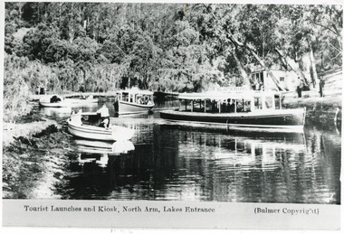 Lakes Entrance Regional Historical Society (operating as Lakes Entrance History Centre & Museum)
Photograph, Bulmers Studio, 1940
Also black and white copy 10 x 15Black and white photograph showing MV Blackbird, a similar launch at back, plus three smaller boats on left, off Comers Tearooms landing at top of North Arm. Thick vegetation on bank. Lakes Entrance VictoriaTourist Launches and Kiosk, North Arm, Lakes Entrance (Bulmer Copyright)waterways, boats and boating, tourism -
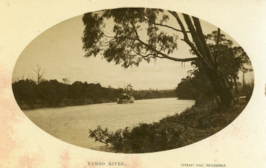 Lakes Entrance Regional Historical Society (operating as Lakes Entrance History Centre & Museum)
Photograph, Vogt. W S, 1915 c
Black and white photograph showing P S Tanjil on Tambo River. Water level high in river, note bushes in water. Eucalypt hanging over the river on right. Thick vegetation on banks. Swan Reach Victoriaships and shipping, jetties, houses, fences -
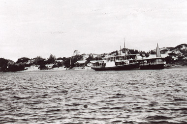
 Lakes Entrance Regional Historical Society (operating as Lakes Entrance History Centre & Museum)
Postcard, 1905c
Message on back of card, to 'Misses M & A Henderson, Swan Reach, Just a line to wish ......, Yours sincerely, R J Gilsenan.'Black and white postcard of the man made entrance. It shows the works building and cottages on each side of the entrance, timber cribs and rock groynes at Bullock Island, natural vegetation of Jemmys Point in foreground. Lakes Entrance VictoriaLakes Entrance, Cunninghamboats and boating, public works, topography, waterways -
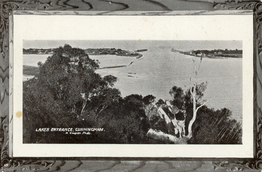
 Lakes Entrance Regional Historical Society (operating as Lakes Entrance History Centre & Museum)
Postcard, 1935c
Also 2 identical small format postcardsBlack and white small format postcard taken from the cliff top at Kalimna. It shows the man made entrance through the hummocks, rock groynes, Jemmys Point cliff and natural vegetation in foreground. Lakes Entrance VictoriaEntrance from Kalimna, Lakes Entrancehouses, waterways, topography -
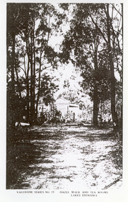 Lakes Entrance Regional Historical Society (operating as Lakes Entrance History Centre & Museum)
Photograph, 1920c
Black and white photograph of Hazel Walk and Tea Rooms at Kalimna. It shows bush track through natural vegetation leading to rustic weather board with canvas awning on the veranda side of tea rooms. Lakes Entrance VictoriaHazel Walk and Tearooms, Lakes Entranceislands, public works, waterways, topography -
University of Melbourne, Burnley Campus Archives
Newspaper - Newspaper Cutting, The Mildura Cultivator, Death of Mr. Geo. Neilson, 1898
Photocopy of article in "The Mildura Cultivator" 08 Jan 1898 p2. Obituary of George Neilson and mention of C.B. Luffmann being asked to temporarily carry out some of the duties of chief inspector under the Vegetation Diseases Act.the mildura cultivator, charles bogue luffman, c b luffmann, george neilson, chief inspector vegetative diseases, vegetative diseases act -
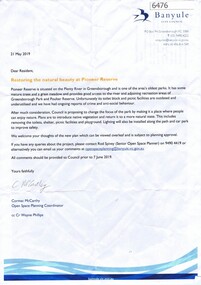 Greensborough Historical Society
Letter, Restoring the natural beauty at Pioneer Reserve, 21/05/2019
Letter to residents, outlining plans to renovate Pioneer Reserve Greensborough by introducing native vegetation and returning it to a more natural state. This includes removing the toilets, picnic shelter and playground.2 p. letter, coloured aerial photograph on back pagepioneer reserve greensborough, banyule council -
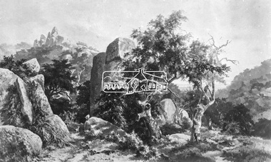 Eltham District Historical Society Inc
Photograph, Rocky Outcrop
A rural location with a visible exposure of bedrock surrounded by vegetation and trees. A rock exposed high hill is in the background. The location and artist are unidentified. The location is reminscent of Hanging Rock, Woodend.This photo forms part of a collection of photographs gathered by the Shire of Eltham for their centenary project book, "Pioneers and Painters: 100 years of the Shire of Eltham" by Alan Marshall (1971). The collection of over 500 images is held in partnership between Eltham District Historical Society and Yarra Plenty Regional Library (Eltham Library) and is now formally known as 'The Shire of Eltham Pioneers Photograph Collection.' It is significant in being the first community sourced collection representing the places and people of the Shire's first one hundred years.Digital imagesepp, shire of eltham pioneers photograph collection, other areas, rocks, bedrock, unknown -
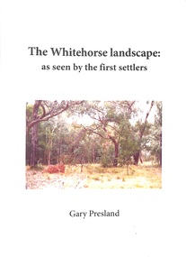 Ringwood and District Historical Society
Book - Booklet, Gary Presland, Booklet titled 'The Whitehorse Landscape' as seen by the first settlers by Gary Presland, 2011. Contains photographs of flora and fauna plus details of the local weather and geology, 2011
The Whitehorse Landscape as seen by the first settlers contains elements of natural history, geology, weather, local hydrology, vegetation and Fauna. With list of sources, glossary of terms and index. With photographs.25 page booklet, indexed. White covers with picture on front and embedded in the text. +Additional Keywords: Presland, GaryThe Whitehorse Landscape' -
Lakes Entrance Regional Historical Society (operating as Lakes Entrance History Centre & Museum)
Postcard, H D Bulmer, 1930 c
Also two identical black and white postcards taken near entry to North Arm showing vegetation die back in foreground bare banks in background 05279.1 and .2Black and white postcard showing passengers on Peels launch Blackbird anchored at tea room jetty north Arm Lakes EntranceH Peels Tourist Launch 'Blackbird'navigation -
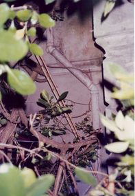 Villa Alba Museum
Photograph - Exterior pipe obscured by foliage, c.1987
Built for William and Anna-Maria Greenlaw in the early 1880s, and with interiors decorated by the Paterson Bros, Villa Alba remained in private ownership until 1949. From 1950, the house was owned by a number of institutions. By 1984, the Villa Alba Preservation Society had been formed, and three years later, the Mount Royal Hospital granted a 25-year lease to Kew Council. In 2004, the title to Villa Alba was passed by the Victorian Government to The Villa Alba Museum Incorporated. The Museum, at 44 Walmer Street, Kew, is now a cultural institution committed to the collection, study and display of 19th century interior decorative finishes, and the components of 19th and 20th century interior decoration.This is one of a number of historically and aesthetically significant photos of the interiors and exterior of Villa Alba when it was still owned by the Mount Royal Hospital, showing twentieth century accretions and deterioration of the historic fabric of the building. This was a benchmark survey against which future conservation and restoration activities can be measured.In December 1987, Mockridge Stahle & Mitchell Pty Ltd Architects prepared ‘Villa Alba Survey: A Report on the fabric for Mount Royal Hospital’ of which this photograph is a part. Photo of cast exterior water pipe party obscured by vegetation.villa alba museum, conservation photographs, victorian architecture, drain pipes -
 Lakes Entrance Regional Historical Society (operating as Lakes Entrance History Centre & Museum)
Photograph, 1920 c
Also one black and white copy of the same image.Black and white photograph showing two steamers at New Works wharf, Cunninghame Arm,Cottages on dune behind steamers. Top of sail visible behind steamer. Sand showing between vegetation on dunes. Lakes Entrance Victoria.ships and shipping, waterways, jetties, islands -
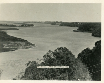 Lakes Entrance Regional Historical Society (operating as Lakes Entrance History Centre & Museum)
Postcard, Valentine Series, 1930c
Other copy similar view with inscription 'The Lakes, Lakes Entrance Vic'Black and white postcard of Reeves Channel Gippsland Lakes, showing Rigby, Fraser and Flannagan Islands opposite the steep shoreline of the mainland. Natural vegetation of Jemmys Point in foreground from which photograph was taken. Lakes Entrance VictoriaKalimna from Jemmys Point Lakes Entranceislands, waterways, topography -
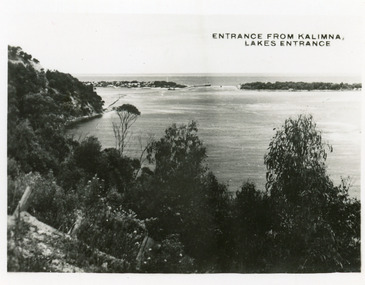
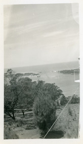 Lakes Entrance Regional Historical Society (operating as Lakes Entrance History Centre & Museum)
Photograph, 1950c
Black and white photograph of the man-made entrance from Bass Strait to the Gippsland Lakes, taken from the lookout tower on Jemmys Point. In foreground is the natural vegetation of Jemmys Point and a glimpse of the light beacon. Lakes Entrance Victoriaislands, waterways, ships and shipping