Showing 374 items matching "136"
-
 Kew Historical Society Inc
Plan - Subdivision Plan, Mount Ida Estate, 1925
The Kew Historical Society collection includes almost 100 subdivision plans pertaining to suburbs of the City of Melbourne. Most of these are of Kew, Kew East or Studley Park, although a smaller number are plans of Camberwell, Deepdene, Balwyn and Hawthorn. It is believed that the majority of the plans were gifted to the Society by persons connected with the real estate firm - J. R. Mathers and McMillan, 136 Cotham Road, Kew. The Plans in the collection are rarely in pristine form, being working plans on which the agent would write notes and record lots sold and the prices of these. The subdivision plans are historically significant examples of the growth of urban Melbourne from the beginning of the 20th Century up until the 1980s. A number of the plans are double-sided and often include a photograph on the reverse. A number of the latter are by noted photographers such as J.E. Barnes.The Mount Ida Estate was a subdivision of fifty-two residential allotments bordering Tooronga Road, Leura Grove, Constance Street, and Mount Ida Avenue in Hawthorn East. The report of the sale of the Estate in The Argus (21 September) claimed that over 1,000 people attended the auction and that all allotments were sold on the day. On the other side of Constance Street, the plan identifies the ‘Eastern Recreation Reserve’ (now Anderson Park).subdivision plans - hawthorn -
 Kew Historical Society Inc
Plan - Subdivision Plan, Jaques Estate, 1927
The Kew Historical Society collection includes almost 100 subdivision plans pertaining to suburbs of the City of Melbourne. Most of these are of Kew, Kew East or Studley Park, although a smaller number are plans of Camberwell, Deepdene, Balwyn and Hawthorn. It is believed that the majority of the plans were gifted to the Society by persons connected with the real estate firm - J. R. Mathers and McMillan, 136 Cotham Road, Kew. The Plans in the collection are rarely in pristine form, being working plans on which the agent would write notes and record lots sold and the prices of these. The subdivision plans are historically significant examples of the growth of urban Melbourne from the beginning of the 20th Century up until the 1980s. A number of the plans are double-sided and often include a photograph on the reverse. A number of the latter are by noted photographers such as J.E. Barnes.The Jaques Estate was a small subdivision of eight residential allotments bordering Jaques Street and Barkers Road in what is now Hawthorn East. Advertised in The Argus as being in ‘Upper Hawthorn’ the subdivision was claimed to include: ‘charming villa sites in excellent situations, with every convenience available, and with superior homes surrounding’.subdivision plans - hawthorn, jaques estate -
 Kew Historical Society Inc
Plan - Subdivision Plan, Houghton Street & Buchanan Avenue, Balwyn North, ca. 1906
The Kew Historical Society collection includes almost 100 subdivision plans pertaining to suburbs of the City of Melbourne. Most of these are of Kew, Kew East or Studley Park, although a smaller number are plans of Camberwell, Deepdene, Balwyn and Hawthorn. It is believed that the majority of the plans were gifted to the Society by persons connected with the real estate firm - J. R. Mathers and McMillan, 136 Cotham Road, Kew. The Plans in the collection are rarely in pristine form, being working plans on which the agent would write notes and record lots sold and the prices of these. The subdivision plans are historically significant examples of the growth of urban Melbourne from the beginning of the 20th Century up until the 1980s. A number of the plans are double-sided and often include a photograph on the reverse. A number of the latter are by noted photographers such as J.E. Barnes.A hand-drawn subdivision plan listing six blocks bounded by Houghton Street, Doncaster Road, Buchanan Avenue and Maud Street, North Balwyn. Written on the plan of subdivision are the lot numbers, the dimensions of the blocks and the price at which two lots were for sale or had been sold for.subdivision plans - balwyn -
 Kew Historical Society Inc
Plan - Subdivision Plan, Doona Estate, Toorak, 1929
The Kew Historical Society collection includes almost 100 subdivision plans pertaining to suburbs of the City of Melbourne. Most of these are of Kew, Kew East or Studley Park, although a smaller number are plans of Camberwell, Deepdene, Balwyn and Hawthorn. It is believed that the majority of the plans were gifted to the Society by persons connected with the real estate firm - J. R. Mathers and McMillan, 136 Cotham Road, Kew. The Plans in the collection are rarely in pristine form, being working plans on which the agent would write notes and record lots sold and the prices of these. The subdivision plans are historically significant examples of the growth of urban Melbourne from the beginning of the 20th Century up until the 1980s. A number of the plans are double-sided and often include a photograph on the reverse. A number of the latter are by noted photographers such as J.E. Barnes.The Doona Estate subdivision of 1929 created 11 new allotments bordered by Glenferrie Road, Stonnington Place, Cross and Church Streets. On the right of the plan, the location of ‘State Govt. House’ is noted. Stonnington was to be maintained as Victoria’s Government House until 1931, two years after the Doona Estate subdivision was released.subdivision plans - toorak, doona estate -
 Kew Historical Society Inc
Plan - Subdivision Plan, Auburn Heights Estate, 1921
The Kew Historical Society collection includes almost 100 subdivision plans pertaining to suburbs of the City of Melbourne. Most of these are of Kew, Kew East or Studley Park, although a smaller number are plans of Camberwell, Deepdene, Balwyn and Hawthorn. It is believed that the majority of the plans were gifted to the Society by persons connected with the real estate firm - J. R. Mathers and McMillan, 136 Cotham Road, Kew. The Plans in the collection are rarely in pristine form, being working plans on which the agent would write notes and record lots sold and the prices of these. The subdivision plans are historically significant examples of the growth of urban Melbourne from the beginning of the 20th Century up until the 1980s. A number of the plans are double-sided and often include a photograph on the reverse. A number of the latter are by noted photographers such as J.E. Barnes.The name ‘Auburn Heights Estate’, was handwritten on the subdivision plan, and included 23 lots in Auburn Road and Wright and View Streets, Hawthorn. Most of the houses built on the lots that were sold still exist. The house built on number 8 View Street is a contemporary exception. The subdivision included an existing home at number 17 View Street.subdivision plans - hawthorn, auburn heights estate -
 Kew Historical Society Inc
Plan - Subdivision Plan, Corsewall Estate, 1938
The Kew Historical Society collection includes almost 100 subdivision plans pertaining to suburbs of the City of Melbourne. Most of these are of Kew, Kew East or Studley Park, although a smaller number are plans of Camberwell, Deepdene, Balwyn and Hawthorn. It is believed that the majority of the plans were gifted to the Society by persons connected with the real estate firm - J. R. Mathers and McMillan, 136 Cotham Road, Kew. The Plans in the collection are rarely in pristine form, being working plans on which the agent would write notes and record lots sold and the prices of these. The subdivision plans are historically significant examples of the growth of urban Melbourne from the beginning of the 20th Century up until the 1980s. A number of the plans are double-sided and often include a photograph on the reverse. A number of the latter are by noted photographers such as J.E. Barnes.The Corsewall Estate was a subdivision, bordering on Barkers Road and Auburn Road, which created Corsewall Close. This relatively late subdivision included 29 allotments. The subdivision plan includes the dimensions of each lot as well as the width of the existing and projected roads and turning circles. The Corsewall Close Precinct is now listed on the Victorian Heritage Database (HO147) and is noted for its ‘consistent flat-type development over the entire street, which has been cleverly designed to make multi-unit dwellings appear as single buildings’.subdivision plans - hawthorn, corsewall estate -- hawthorn (vic.) -
 Kew Historical Society Inc
Plan - Subdivision Plan, Pointed Firs Estate, 1936
The Kew Historical Society collection includes almost 100 subdivision plans pertaining to suburbs of the City of Melbourne. Most of these are of Kew, Kew East or Studley Park, although a smaller number are plans of Camberwell, Deepdene, Balwyn and Hawthorn. It is believed that the majority of the plans were gifted to the Society by persons connected with the real estate firm - J. R. Mathers and McMillan, 136 Cotham Road, Kew. The Plans in the collection are rarely in pristine form, being working plans on which the agent would write notes and record lots sold and the prices of these. The subdivision plans are historically significant examples of the growth of urban Melbourne from the beginning of the 20th Century up until the 1980s. A number of the plans are double-sided and often include a photograph on the reverse. A number of the latter are by noted photographers such as J.E. Barnes.An almost identical plan of the ‘Pointed Firs Estate’ is in the State Library of Victoria. The plan unusually uses a photograph to show the panoramic views from the Estate. A prospective purchaser could expect to look across the Yarra Valley to Eaglemont and Heidelberg. The 36 lots advertised for sale faced Doncaster Road, Houghton Street, Maud Street and Thackray Street in Balwyn North.subdivision plans - balwyn, pointed firs estate -
 Kew Historical Society Inc
Plan - Subdivision Plan, Lodged Plan No.6518, 1920-1940
The Kew Historical Society collection includes almost 100 subdivision plans pertaining to suburbs of the City of Melbourne. Most of these are of Kew, Kew East or Studley Park, although a smaller number are plans of Camberwell, Deepdene, Balwyn and Hawthorn. It is believed that the majority of the plans were gifted to the Society by persons connected with the real estate firm - J. R. Mathers and McMillan, 136 Cotham Road, Kew. The Plans in the collection are rarely in pristine form, being working plans on which the agent would write notes and record lots sold and the prices of these. The subdivision plans are historically significant examples of the growth of urban Melbourne from the beginning of the 20th Century up until the 1980s. A number of the plans are double-sided and often include a photograph on the reverse. Reconciling this hand-drawn subdivision plan with a modern map of the area is initially a challenge due to a change of street names. Argyle Road in the centre of the subdivision was to be renamed Deepdene Road, and the street named Deepdene Road on the plan was to become Deepdene Place. Of interest is the nursery on the corner of Argyle and Whitehorse Roads. During this period there were a number of nurseries servicing the Kew and Balwyn areas. The subdivision was essentially of the land formerly occupied by the house 'Deepdene'.subdivision plans - balwyn, deepdene, whitehorse road -- deepdene (vic.), deepdene road -- deepdene (vic.), burke road -- deepdene (vic.) -
 The Beechworth Burke Museum Research Collection
Card (Series) - Index Card, George Tibbits, 14 William Street Beechworth (cnr Last St), 1976
George Tibbits, University of Melbourne. Faculty of Architecture, Building and Town & Regional PlanningIndex system that support the research for Beechworth : historical reconstruction / [by] George Tibbits ... [et al]Arranged by street names of BeechworthEach index card includes: street name and number of property, image of property, allotment and section number, property owners and dates of ownership, description of the property according to rate records, property floor plan with dimensions.beechworth, george tibbitsbeechworth, george tibbits -
 Bendigo Historical Society Inc.
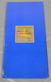
Leisure object - QC Binks collection: board game
This game was advertised as a "new game" in 1909.Board game called Advance Australia. The board is divided in 144 squares with 136 numbered consecutively. The game was played with a pair of dice. The game has its unique form, with shipwrecks, lost in the outback, hazardous landings and high seas being some features. The leather tumbler and dice are with the game. Also, with the game there are two newspaper articles, one by David Horsfall the other by Leighton Rawlings giving a detailed description of the game. From the map details it is reasonable to guess the game was produced early 1900s. Chad Valley series of gamesgame, boardgame, early federation -
 Bendigo Historical Society Inc.
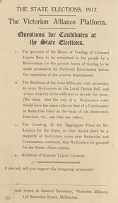
Document - BENDIGO TOTAL ABSTINENCE SOCIETY COLLECTION: THE VICTORIAN ALLIANCE PLATFORM, THE STATE ELECTIONS,1917, 1917
Document. the State Elections, the Victorian Alliance Platform, Questions for Candidates at the State Elections. 1. The question of the Hours of Trading of Licensed Liquor Bars to be submitted to the people by a Referendum. 2. The Abolition of the three-fifths per cent, necessary to carry No-Licence at the Local Option Poll. 3. The Counting of the Aggregate Votes for No-Licence for the State. 4. Abolition of Grocers' Liquor Licences. If elected, will you support the foregoing proposals? And return to General Secretary. Victorian Alliance, 136 Swanston Street, Melbourne.organisation, community, abstinence society -
 Port Melbourne Historical & Preservation Society
Book - Reference, Gary Presland, Records of the Victorian Archeological Survey, 1977 - 1983
Purchased from Information Victoria, circa 2000Victorian Archeological Survey books by Gary Presland (editor or author). .01 - No5, 1977. Journals of George Augustus Robinson Jan -March 1840 (light orange cover 96 pages plus fold out route map) .02 - No 6 1977. Journals of George Augustus Robinson March - May 1841 (orange cover 102 pages plus fold out route map and illustrations) .03 - An archeological survey of the Melbourne Metropolitan area 1983 (yellow cover 136 pages)australian aborigines, natural environment, gary presland, george augustus robinson, archeology -
 Greensborough Historical Society
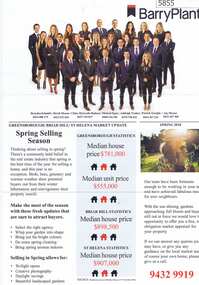
Advertising Leaflet, Barry Plant Bundoora, Barry Plant Spring selling season, 2018_08
Spring selling season leaflet with sales results on back of page. 4 Murumba Street Greensborough, sold $1,115,000 ; 11 Sun Orchid Circuit St Helena sold $870,00; 6 Weemala Court Greensborough sold $1,666,000; 6 Howard Street Greensborough sold $737,000; 136 Elder Street Greensborough sold $772,000; 140 Mountain View Road Briar Hill sold $638,000 and 12 Sunrise Drive Greensborough sold 2018 for $1,320,000, previous sales January 1994 $103,000, July 1989 $100,000 and July 1988 $85,500.Real estate advertising leaflet, 1 sheet, printed in colour on both sides.sunrise drive greensborough, murumba street greensborough, sun orchis circuit st helena, elder street greensborough, howard street greensborough, mountain view road briar hill, weemala court greensborough -
 Bacchus Marsh & District Historical Society
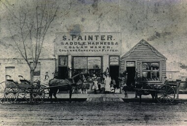
Photograph, Samuel Painter Saddler Shop
Samuel Painter, saddler, enlarged George Taylor's premises after buying the building in 1888. He carried on the saddlery while his wife conducted a fancy goods shop. The building on the left was occupied by a bootmaker, Abraham Tracey. The 2025 location for this site is 136 Main Street, Bacchus Marsh. By around 1894 the saddlery and fancy goods business operated by the Painters had ceased. The premises were then used as a greengrocery and confectionery business for some years until this business ceased and the site became the location of a branch of the State Savings Bank of Victoria for many years. Copy of photograph of S. Painter's Saddlery, showing a group of buildings in Main Street, Bacchus Marsh in the later part of the 19th century, post 1883. On the left can be seen part of a building which bears the sign A. Tracey. The middle building carries a large sign advertising the proprietor and his business. It has a large double window, flanked on either side with a doorway. A variety of goods can be seen in the window. On the right is a weatherboard building also set up as a shop. At the front of this complex can be seen two men both wearing work aprons and three children standing on the footpath. Two buggies are pulled up in front of the complex, one four-wheeled, one two wheeled, the smaller vehicle pulled by a pony. The deep gutter is bridged by boards giving access to the unmade road. On the front: Sign above central building: S.PAINTER. SADDLE HARNESS & COLLAR MAKER. COLLARS CAREFULLY FITTED. On the central window can be seen a sign reading Stationery & Fancy Goods. On the window above the door: Bacchus Marsh Emporium. On the back: Handwritten: Bought by Bowden. Old building on left replaced by W.J.Wilson Hairdresser 1896. Painter Main Street now State Bank.saddlery, shops bacchus marsh vic., small businesses bacchus marsh, fancy goods, george taylor, bootmakers, samuel painter -
 Kiewa Valley Historical Society
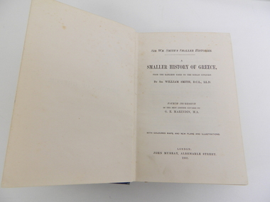
Book - History, Smaller History of Greece, from the earliest times to the Roman conquest, 1903
This book was used as a text book at Camberwell Grammar School by Jack Roper whose family lived and farmed at Mt Yorke Station, Tawonga. At the time there wasn't a local High School, the closest one being in Albury. Historical: Students studied History. Country students boarded in Melbourne for their education. Provenance: Jack Roper had a private school education. His family still live and farm in the Kiewa Valley. Comparative to his descendants' education.Blue book with embossed hard cover including cloud like patterns in a rectangular shape around the title.Inside cover - hand written: Jack Roper / Camberwell G.S. / Jack Rooper / Mt Yorke Station / Tawonga/ Via Yackandandah Also handwritten notations: Marathon 490; 130 to 136 History; 4 chapter after holidays 18 to 24; !V chapter. Also smudged ink stain.education. history. greece. jack roper. mt yorke station. tawonga. camberwell grammar school. -
 Bacchus Marsh & District Historical Society
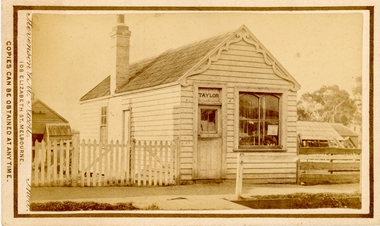
Photograph, Saddlery Shop of George Taylor Main Street Bacchus Marsh 1883
This image is one of a series of photographs taken by Melbourne based photographers Stevenson and McNicoll who visited Bacchus Marsh and its nearby districts between September and November 1883. George Taylor was in business in Bacchus Marsh from 1866. He built these premises in Main Street in 1868 and remained in business until 1888 when Samuel Painter brought the property and operated his own saddlery business. The location was later used for the State Savings Bank of Victoria and the Bank of New South Wales (Westpac). The location of this site in 2024 is 136 Main Street, Bacchus Marsh.Small sepia 'carte de viste' style unframed photograph on card with gold border framing photograph. Housed in the album, 'Photographs of Bacchus Marsh and District in 1883 by Stevenson and McNicoll'. The image shows a single storey timber building with a pitched roof. The front of the gable has an ornamental wooden fretwork design attached.The name 'Taylor' can be clearly seen above the front door. There is one large window. The roof appears to be slate and the building has one chimney. Outhouses can be seen to the left and right of the building. There is a picket fence to one side of the building and a post-and-rail fence to the other.Printed On the front: Stevenson & McNicoll. Photo. 108 Elizabeth St. Melbourne. COPIES CAN BE OBTAINED AT ANY TIME. On the back: LIGHT & TRUTH inscribed on a banner surmounted by a representation of the rising sun. Copies of this Portrait can be had at any time by sending the Name and Post Office Money Order or Stamps for the amount of order to STEVENSON & McNICOLL LATE BENSON & STEVENSON, Photographers. 108 Elizabeth Street, MELBOURNE. stevenson and mcnicoll 1883 photographs of bacchus marsh and district, saddleries, saddlers -
 Bendigo Historical Society Inc.
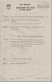
Document - H. A. & S. R. WILKINSON COLLECTION: CONTRACT OF SALE
Contract of sale of real estate dated 12th November, 1964 between Mr. M. J. Brown (vendor) and Mrs. D. M. Samson (purchaser). Solicitor for vendor: Messrs. E. S. Cahill & Son, View Street, Bendigo. Solicitor for purchaser: Messrs. Watson, James & Rogers, View Point, Bendigo. Property 136 Mollison Street being Crown allotment17 section 5C land described in certificate of title volume 3174 folio 787 together with floor coverings. Price 3,100 pounds.organization, business, h.a. & s.r wilkinson real estate -
Glenelg Shire Council Cultural Collection
Photograph - Photograph - Sheet of 6 Contact Prints - Silo Construction, c. 1964
Port of Portland Authority ArchivesFront: '28-10-64 129 28-10-64 135 (printing reversed) 28-10-64 136 (printing reversed) 28-10-64 130 28-10-64 131 28-10-64 132' - beneath each print in white Back: 130 132 129 - in pencilport of portland archives -
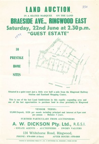 Ringwood and District Historical Society
Flyer - Land Auction, Guest Estate, Ringwood East - 1974
Two copies of single page with green print advertising auction of ten home sites on Saturday 22nd June (1974). Details include subdivision map and vendor terms. Second copy of flyer includes handwritten notation of allotment sale prices.Subdivision layout includes Mount Dandenong Road, Braeside Avenue and Guest Close, Ringwood East. Agent: A.W. Dickson, 136 Whitehorse Road, Ringwood, Phone 870-6000, after hours 870-6868. Printed by Whitehorse Press Pty. Ltd., 14 Whitehorse Road, Ringwood, Phone 870-7855. -
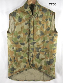 Bendigo Military Museum
Uniform - VEST, WORK DRESS - ARMY, Australian Defence Industries
Vest used by Artillery.DCPU (Disruptive Pattern Camouflage Uniform) Work Dress vest. Colours - light to dark green through to light to dark brown, nylon fabric. Stand up collar, two front pockets, front fastening - nylon and plastic zipper. Vest lining - light green nylon fabric.Manufacturers Information on label - black ink print. "WALKABOUT/ TRADITIONALLY AUSTRALIAN/ NSN 8415-66-136-4647/ 94/ SIZE 105 CM CHEST/ NAME/ SERVICE NO./ MACH. WASHABLE WARM WATER ONLY/ DO NOT BLEACH/ DO NOT IRON/ DO NOT STEAM PRESS/ NYLON INNER/ OUTER - POLYESTER FILLED/ MADE IN AUSTRALIA." uniform, army, work dress, dpcu, vest -
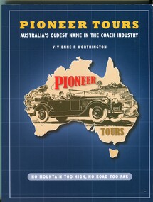 Orbost & District Historical Society
Book, Worthington, Vivienne, PIONEER TOURS, December 1 2009
This book was written by Vivienne Worthington, a relative of the family of Albert Withers, the founder of Pioneer Coach Tours. From the hire of his first vehicle in 1905 Albert Withers always used the name 'Pioneer', until he ultimately established Pioneer Tourist Coaches, which became 'the largest of its kind in the Commonwealth' and in many respects unique. It began with motoring in Victoria and eventually covered the whole of Australia.This book is a useful reference tool.A paperback book of 136 pp. The cover is dark blue with the title, " Pioneer Tours" in yellow print at the top and "oldest name in the coach industry / Vivienne R Worthington" in white print beneath it. In the centre is an outline of a fawn coloured map of Australia with a black drawing of a family in a touring car. - probably from 1930s. At the top in red print is "PIONEER" and below the drawing in brown print is "TOURS" At the bottom of the page is "NO MOUNTAIN TOO HIGH NO ROAD TOO FAR" in white print inside a pale blue rectangle with rounded ends. It contains black / white photographs and the history of the Pioneer Travel Company. on cover at bottom in white "NO MOUNTAIN TOO HIGH NO ROAD TOO FAR" on cover at top - "PIONEER TOURS : AUSTRALIA'S OLDEST NAME IN THE COACH INDUSTRY / VIVIENNE R WORTHINGTON."transport tourism pioneer-coach-tours worthington-vivienne -
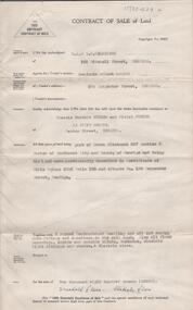 Bendigo Historical Society Inc.
Document - H. A. & S. R. WILKINSON COLLECTION: CONTRACT OF SALE
Contract of sale of land dated 15th November, 1956 between Mr. B. A. Bolton and Mr. F. B. & Mrs. V. Turner. Property: that piece of land being Crown allotment 327 section H Parish of Sandhurst city of Bendigo, land described in certificate of title volume 3556 folio 136 and situate No. 184 Carpenter Street, Bendigo, together with 6 roomed weatherboard dwelling and all sundry outbuildings, also all floor coverings, inside and outside blinds, curtains, electric light fittings and shades and electric stove. Price: 2,800 pounds. .organization, business, h.a. & s.r wilkinson real estate -
 Ballarat Tramway Museum
Document - List, "Fremantle Municipal Tramways and Electric Lighting Board - Rolling Stock Data List", 1950
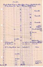
Handwritten list titled ""Fremantle Municipal Tramways and Electric Lighting Board - Rolling Stock Data List" listing the tramcars of Fremantle, builder, date, motors, length, car type and history of conversions. Dated as at 1/1/1950. Handwritten on lined foolscap paper with four punch holes on left hand edge. Contained originally within Reg Item 5623 at the front of this note book. For items see BTM5623 loose items list.pdf. See also Reg Item 152 for other information obtained by Wal and also Reg item 136 for a list prepared by Wal Jack.fremantle, tramcars -
 Ballarat Tramway Museum
Photograph - Digital image, 1950 or earlier
Yields information about SEC Ballarat tram No. 19 - one of a series of official photographs in 1950 or earlier and the appearance of the tram.Digital Image of SEC Ballarat No.29 in the 1950 or earlier in Wendouree Parade with the Lake and one of the rowing sheds in the background. SEC Official photograph. A tow bar is in position indicating the tram has towed out of the shed for the photograph. The drivers front window is upside down, missing handrails, steps, destination box, glass in the front headlight, life guard and other parts - indicating the tram has been out of use for some time. The tram was scrapped in 1950. See Reg Item 4568 for the CD. See Page 136 of The Golden City and its Trams, re scrapping date of No. 29.trams, tramways, secv, wendouree parade, tram 29 -
 Melbourne Tram Museum
Photograph - Black and White Photos - MMTB P Class Tram 136 at Hawthorn, pre May 1925
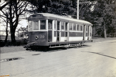
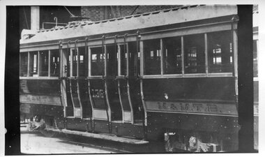
Photo shows one of the Maximum Traction Bogies trams built for the Hawthorn Tramways Trust by Duncan and Fraser of Adelaide in 1917-1918. Photographed in the Hawthorn Depot some time before May 1925. This tram began its life as HTT No. 30. The body was sold in 1944. The full photo appears on page 17 of Tramway by the River.Yields information about early liveries of MMTB ex HTT bogie trams.Two photos of former HTT bogie tram No. 136 at Hawthorn Depot before May 1925. On rear of photo 1, it is noted that the paintwork was that before May 1925. Other notations (1) Long piece of barrier rail along drop centre (2) Monogram (HTT) on saloon doors (3) Triple railings over bulkhead windows (4) Cylindrical destination box (on rear). Notes on photo 2, (1) paintwork was that before May 1925 (2) Route No D (3) Monogram (HTT) on saloon door (4) Triple railings over bulkhead window (5) Old destination box (6) Iron gates.See notes above.tramways, trams, hawthorn depot, tram 136, mmtb, htt, p class, route d -
 Kew Historical Society Inc
Plan - Subdivision Plan, Camberwell Mountain View Estate, 1923
The Kew Historical Society collection includes almost 100 subdivision plans pertaining to suburbs of the City of Melbourne. Most of these are of Kew, Kew East or Studley Park, although a smaller number are plans of Camberwell, Deepdene, Balwyn and Hawthorn. It is believed that the majority of the plans were gifted to the Society by persons connected with the real estate firm - J. R. Mathers and McMillan, 136 Cotham Road, Kew. The Plans in the collection are rarely in pristine form, being working plans on which the agent would write notes and record lots sold and the prices of these. The subdivision plans are historically significant examples of the growth of urban Melbourne from the beginning of the 20th Century up until the 1980s. A number of the plans are double-sided and often include a photograph on the reverse. A number of the latter are by noted photographers such as J.E. Barnes.The so-called Camberwell Mountain View Estate was a subdivision on ‘the corner [of] Burke Road, Eyre and Wills Streets, Deepdene’. The Estate was not the first attempt to subdivide this land holding. In 1884, 1888 and 1894 the Belmore Park subdivision proposed 18 allotments for this parcel of land. The final stages of the Belmore Park subdivision occurred during the Depression of the 1890s. Apart from perhaps one block facing Burke Road, which is unnumbered in the Mountain View Estate subdivision, the rest must have remained unsold. The later subdivision would redraw the original 18 allotments, creating 22 new lots. In the Locality Plan on the left side of the subdivision plan, Deepdene Station, which formed part of the Outer Circle Railway is represented, as is the location of Deepdene Primary School. A selling point was the proposed extension of the Burke Road tram beyond its terminus at Cotham Road. The extension did not eventuate.subdivision plans - camberwell, mountain view estate -
 Ringwood and District Historical Society
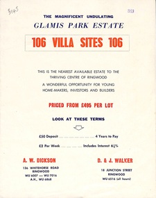
Flyer, Land Sale Brochure, Glamis Park Estate (Wantirna, Vic.) - 1959
Street name Carnarvon Avenue on the subdivision plan became Selkirk Avenue at some stage during or subsequent to development of the Estate.Bi-folded advertisement for sale of residential allotments, including summary of subdivision features and local facilities.Subdivision includes Wantirna streets - Wantirna Road, Carnarvon Avenue, Inchcape Avenue, St Thomas Avenue, St Davids Drive, Dudley Avenue, Angus Avenue. Agents - A.W. Dickson, 136 Whitehorse Road, Ringwood, Telephone WU 6007, WU 7016, A.H. WU 6868. D. & J. Walker, 18 Junction Street, Ringwood, Telephone WU 6516 (all hours). -
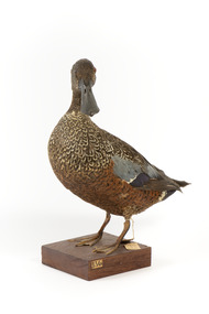 The Beechworth Burke Museum
Animal specimen - Australiasian Shovelor, Trustees of the Australian Museum, 1860-1880
The Australasian Shoveler is a species of duck that can be commonly found in heavily vegetated swamps in southwestern and southeastern Australia, Tasmania and New Zealand. The species, Australasian Shoveler, is aptly named after their large shovel-shaped bill. These birds use these large bills which are equipped with fine hair-like components which strain the water and mud for food including tiny creatures including insects, crustaceans and seeds while it swims. This specimen is part of a collection of almost 200 animal specimens that were originally acquired as skins from various institutions across Australia, including the Australian Museum in Sydney and the National Museum of Victoria (known as Museums Victoria since 1983), as well as individuals such as amateur anthropologist Reynell Eveleigh Johns between 1860-1880. These skins were then mounted by members of the Burke Museum Committee and put-on display in the formal space of the Museum’s original exhibition hall where they continue to be on display. This display of taxidermy mounts initially served to instruct visitors to the Burke Museum of the natural world around them, today it serves as an insight into the collecting habits of the 19th century.This specimen is part of a significant and rare taxidermy mount collection in the Burke Museum. This collection is scientifically and culturally important for reminding us of how science continues to shape our understanding of the modern world. They demonstrate a capacity to hold evidence of how Australia’s fauna history existed in the past and are potentially important for future environmental research. This collection continues to be on display in the Museum and has become a key part to interpreting the collecting habits of the 19th century.This Australasian Shoveler is a species of low-floating duck with a dark head and brown plumage. The rear of this specimen is a dark brown, with mixed white and brown colouring on the upper torso. The underparts of this bird are brown and orange. The specimen has glass eyes made in an amber colour. The Shoveler is standing on a wooden platform which is labelled number 136. Amongst the feathers on the wings, this bird has a green coloured feather. The legs of the Shoveler would have once been a bright orange; however, the legs of this specimen have darkened in colour throughout the taxidermy process. This bird has a large bill shaped like a shovel from which the name "Shoveler" has been derived.5a. / Australian Shoveller / See Catalogue, page 38. /taxidermy mount, taxidermy, animalia, burke museum, beechworth, australian museum, skin, reynell eveleigh johns, bird, australian birds, heron, duck, australaisian shovelor, shovelor -
 Whitehorse Historical Society Inc.
Document, Deep Creek Road, 13/04/1929
Photocopy of Certificate of Title Vol 5525 Fol. 1104883, land fronting on Deep Creek Road, Mitcham being lot 136 on Plan of Subdivision No 8022, part of Crown Portion 128A, Parish of Nunawading, County of Bourke, in the name of Francisco Schwerkolt, 13 April 1929, on her death in 1946, probate granted to Charles Victor Schwerkolt.Passed to Frances Dora Hogan in 1947, Alice Maud Everitt in 1950, Charles Edward Everitt and Muriel Eileen Priscilla Edwards in 1953, Stanley Ernest Edward Dawson and Iris Rae Dawson in 1973, Glenn Joseph Benham and Judith Rae Benham in 1975 and Ernest Victor Copling and Barbara Ruth Copling in 1980.deep creek road, mitcham, schwerkolt, francesca, charles clarence victor, schwerkolt cottage, hogan, frances dora, everitt, alice maud, charles edward, edwards, muriel eileen priscilla, dawson, stanley ernest edward, iris rae, benham, glenn joseph, judith rae, copling, ernest victor, barbara ruth -
 Kew Historical Society Inc
Plan - Subdivision Plan, 10 Fine Villa Sites: Ermington Estate, Kew Heights, ca. 1917
Pru Sanderson, in her groundbreaking ‘City of Kew Urban Conservation Study : Volume 2 - Development History’ (1988), summarised the periods of urban development and subdivisions of land in Kew. The periods that she identified included 1845-1880, 1880-1893, 1893-1921, 1921-1933, 1933-1943, and Post-War Development. These periods were selected as they represented periods of rapid growth or decline in urban development. An obvious starting point for Sanderson’s groupings involved population growth and the associated economic cycles. These cycles also highlighted urban expansion onto land that was predominantly rural, although in other cases it represented the decline and breakup of large estates. A number of the plans in the Kew Historical Society’s collection can also be found in other collections, such as those of the State Library of Victoria and the Boroondara Library Service. A number are however unique to the collection.The Kew Historical Society collection includes almost 100 subdivision plans pertaining to suburbs of the City of Melbourne. Most of these are of Kew, Kew East or Studley Park, although a smaller number are plans of Camberwell, Deepdene, Balwyn and Hawthorn. It is believed that the majority of the plans were gifted to the Society by persons connected with the real estate firm - J. R. Mathers and McMillan, 136 Cotham Road, Kew. The Plans in the collection are rarely in pristine form, being working plans on which the agent would write notes and record lots sold and the prices of these. The subdivision plans are historically significant examples of the growth of urban Melbourne from the beginning of the 20th Century up until the 1980s. A number of the plans are double-sided and often include a photograph on the reverse. A number of the latter are by noted photographers such as J.E. Barnes.In November 1917, the Ermington Estate was advertised as an ‘Executor’s Sale’. It included the 10-roomed villa residence, ‘Ermington’, home of the late Mrs. Lorimer, and 10 ‘magnificent allotments’. The plan in the Kew Historical Society Collection is a little more specific. Ermington is described as having 9 Rooms &c. and there are 11 lots shown on the west side of Hillcrest Avenue. In the plan, the latter is named as ‘Hill Crest Avenue’. The plan indicates that the subdivision was based on the surveying work of Johnson & Tait. Opposite Ermington, the existing house ‘Parkhill’ is identified. A faded stamp on two parts of the plan indicates that it was in the possession of Jas. [R.] Mathers, Financial Agent, [136] Cotham Road, Kew.subdivision plans - kew, ermington heights estate - kew heights