Showing 1506 items matching "acres"
-
 Bendigo Historical Society Inc.
Map - CAMPBELL COLLECTION: BENDIGO AND DISTRICT MAPS, 16-4-29
Map. Kennington, Parishes of Sandhurst, Mandurang and Strathfieldsaye. Scale 20 chains to 1 inch. Total area 2918 acres. Bendigo 2 1/2 miles. Prepared in W.B. from A.and C. L. Plans by W.J. Galbraith, 16-4-29. (number 364 in map cupboard 1)W.J.Galbraithmap, bendigo, allotments -
 Bendigo Historical Society Inc.
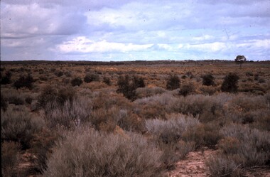
Slide - PETER ELLIS COLLECTION: SLIDE, May 1970 - Jan 1972
Coloured slide transparency. Image is of a bush area. There is dense scrub with low growing flowering yellow wattle in the foreground. The words, Regeneration cleared 1964-66? Robertson are handwritten across the top border and the words Bagshot area (Burnsides originally) 2-3 thousand acres handwritten across the bottom border.Kodachrome Transparencyslide, bendigo, bendigo institute of technology -
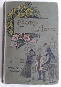 Mont De Lancey
Book, Mrs. C.M. Clarke, Con's Acre - a tale of Gillcourt Farm, c late 1800's
A story about young women growing up in England with the trials and tribulations of young love and friendship. Family life in the late 1800's is depicted with strong religious themes.Faded khaki coloured Children's fiction book - with the title Con's Acre by Mrs C.M. Clarke written in yellow lettering in a box at the top surrounded by yellow and pink flowers. Author's name in black is at the bottom underneath an illustration of a man helping a lady alight from a carriage with another woman close by. 160p.fictionA story about young women growing up in England with the trials and tribulations of young love and friendship. Family life in the late 1800's is depicted with strong religious themes. religious stories, family life stories -
 Eltham District Historical Society Inc
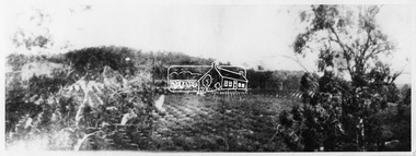
Photograph, Hurstbridge - Gray's Orchard, 1900
W.G (William George) Gray, owned and managed Allwood Nurseries in Hurstbridge. By 1922 he operated a well cultivated property of 64 cleared acres, 56 of which were under nursery healthy stock, principally apples, peaches, plums and cherries. In addition to 4 acres of potatoes. This photo forms part of a collection of photographs gathered by the Shire of Eltham for their centenary project book, "Pioneers and Painters: 100 years of the Shire of Eltham" by Alan Marshall (1971). The collection of over 500 images is held in partnership between Eltham District Historical Society and Yarra Plenty Regional Library (Eltham Library) and is now formally known as 'The Shire of Eltham Pioneers Photograph Collection.' It is significant in being the first community sourced collection representing the places and people of the Shire's first one hundred years.Digital imagesepp, shire of eltham pioneers photograph collection, hurstbridge, gray's orchard, nurseries (plants), apple industry, allwood, allwood nursuries -
 Eltham District Historical Society Inc
Photograph, Peter Bassett-Smith, Former Brinkkotter Poultry Farm, Main Road, Research, April 1988, 1988
Four colour photographs of the former Brinkkotter Poultry Farm, Main Road, Research depicting the 'Regency Acres' real estate development of 22 lots advertised for auction 19 April 1988. The four photographs are shot by Peter Bassett-Smith in a panoramic sweep of the estate from Eltham College to the Research Primary School.poultry farm, main road, research vic., brinkkotter -
Ringwood and District Historical Society
Newspaper Cutting, The Sun, Ringwood Development article (Sun Newspaper) 23 Aug 1960, 23-Aug-60
Article about land 'frieze' of the 16 acres of land for the proposed development site for Eastland.Article about Ringwood development in Sun newspaper. Double page. +Additional Keywords: Lavis, A.G., Mayor / Dwerryhouse, F.P., Town ClerkLand 'Frieze' at Ringwood. -
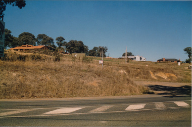
 Eltham District Historical Society Inc
Photograph - Black and White Print, Unidentified road, Eltham district, c. Sep. 1966
On the left is an advertising sign for a housing development lots for auction sale, 20 acre lotsBlack and white photographic printOriginally located in a Filmpro King Size Prints processing envelope $3.01 Shire of Eltham 9/9/66 and noted as Calrossie Ave area and crossed out Eltham-Yarra Glen Road, Bridge Street to Elsa Court existing conditions mid 1967auction sale, housing estate, infrastructure, real estate agent, roads, sign, unidentified -
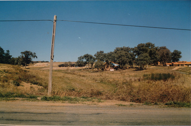
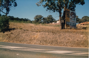
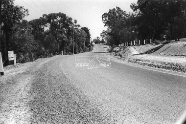
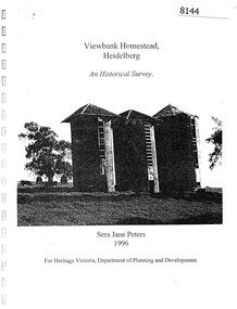 Greensborough Historical Society
Booklet, Sera Jane Peters, Viewbank Homestead, Heidelberg: an historical survey, by Sera Jane Peters for Heritage Victoria, Department of Planning and Development, 1996
History of the Viewbank Homestead, originally a 90 acre site with homestead and outbuildings, now demolished.Black and white photocopy of typescript, with photographs, plans, reproductions of documents. 25 p plus 17 p of Appendices, unboundviewbank homestead, heritage victoria -
Hume City Civic Collection
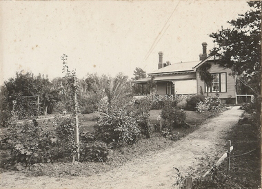
Photograph, Rupertswood Gardens
The gardens in the image are at Rupertswood and originally covered 99 acres. They were designed by William Sangster.A non-digital black and white photograph with a cream border, of extensive grounds set in a wide valley.sir william john clarke, janet lady clarke, rupertswood mansion, william sangster, gardens, salesian college -
 Melton City Libraries
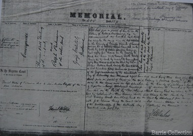
Document, Darlingsford land title, 1863
Thomas Bell Darling purchased 176 acres from the Toolern Creek to Ferris Road. A house and bluestone barn/stables were built. The property was owned by Ralph Parkinson, followed by Richard Manning. SUMMARY – Darlingsford – Auction 1910 Darlingsford – Auction 1910 Melton Express October FRIDAY, October 28th At Three O’Clock At the RAGLAN HOTEL, MELTON SUBDIVISIONAL SALE of the DARLINGSFORD ESTATE, MELTON. Having a long frontage to the TOOLERN CREEK. In the Estate of the late RICHARD MANNING’ W. S. KEAST and L.A. FAIRBAIRN & CO., Auctioneers (in conjunction). Have received instructions from R.F. and J.L. Robertson, executors of Richard Manning deceased to offer by Public Auction, property almost adjoining Melton township, and having a frontage to the Toolern Creek, subdivided in to four lots as under:- Lot 1. – The homestead block containing 176 acres, being portion A, section 11, parish Kororoit together with the improvements, which consist of a 6-roomed stone house, milking shed, dairy, U.G. tank. Lot 2 – 177 acres 2 rood 23 perches, being Crown portion B of section 11 parish Kororoit. This block adjoins the homestead and is partly fenced. Lot 3 – 187 acres, Crown allotment C, section 11, parish Kororoit. adjoining the above lot. Lot 4 - 157 acres 1 rood 27 perches, being Crown allotment 9, section 12, parish of Kororoit. This block is only divided from the above lots by road, and adjoining Messrs. McVean and Gaitskill’s properties. This is one of the best known properties in the Melton district as a cultivation an grazing form, and its close proximity to the township makes it a very valuable, and portion of which could be cut into township blocks and should command a ready sale. For absolute sale. Terms- one fifth cash, one fifth in eight years, balance in 7 years with interest a the rate of 4 1/2 percent. Plan on application For further particulars apply W.S. KEAST, 610 Collins street, Melbourne; and L.A. FAIRBAIRN & Co., St James-buildings, Williams street, or at Bacchus Marsh; and as to the title, Dugdale and Creber, St. James-buildings, William Street Melbourne. Express November 5, 1910 On Friday last, Mr W.S. Keast and Messrs L.A. Fairbairn & Co., in conjunction, offered at the Raglan the Manning Estate known as Darlingsford, comprising of 700 acres, divided into four lots. Lot 4 was submitted first and passed in at L8 per acre. Lot 1 was then put up and went up to L13 per acre, at which it was also passed in. Lot 3 was next offered, and there being no bid was also passed in. Lot 2 was not offered. Express March 18, 1911 The Manning Estate of Darlingsford 600 acres was sold to Mr. Ernie for an undisclosed price. Note: Map KOROROIT COUNTY OF BOURKE Crown Grant Section 11 Portion A Thomas. B. Darling 176 . 0 . 0 acres on 29.3.1853 Lot 1 Portion B A. Russell 170 . 0 . 0 acres on 29.3.1853 Lot 2 Portion C Peter Inglis 176 . 0 . 0 acres on 29.3.1853 Lot 3 Section 12 Portion 3 P. Inglis 157 . 1 . 27 acres on 17.17.1863 Total 176 170 176 157. 1.27 679 . 1.27 acres November 5th 1910 On Friday night last Mr W S Keast and Messrs L A Fairbairn & Co, in conjunction offered at the Raglan Hotel the Manning Estate known as Darlingsford, comprising of 700 acres, divided into four Lots. Lot 4 was submitted first, and was passed in at L8.0.0. per acre. Lot 1 was then put up and went to L13.0.0. per acre at which it was passed in. Lot 3 was next offered, and then Lot 3 was next offered, and then being no bid was passed in. Lot 2 was not offered. October 22nd Notice of sale. 700 acres of splendid land close to the railway station. Divided onto 4 Lots 3 of which are maiden land and the whole of the acres is chocolate soil. No 1 Lot belonged to the late Mr Ralph Parkinson, and for years was liberally supplied with manure and crushed bones, and is capable of producing many crops.. The property being sold to wind up the Estate. Gisborne Gazette Friday December 17th 1911 Mr Sharp has sold his farm at the back of the township to Mr. E Barrie; price L15/10/ per acre. Agreement between Thomas Bell Darling and Ralph Parkinsonlocal identities -
 Bendigo Historical Society Inc.
Photograph - T C WATTS & SON COLLECTION: 'TIRRANNIE' GOLDEN SQUARE, 1929
Thomas Crouch Watts was born on March 7th. 1865, to Joseph and Susan Watts. Before the real estate business commenced, Thomas and his brother were in partnership as booksellers and stationers in a shop at View Point. Thomas lived in a fine house in Rowan Street, which was called 'Ottawa' Thomas started his real estate business in the early 1900s in a shop in View Street. His daughter Edna was the book keeper and typist, Stewart Watson was the salesman and Stanley Phipps (Edith Lunn's father) was the property manager and valuer. When Thomas Watts died in 1914, his daughter took over the running of the business. She married Stewart Watson in 1918. Eventually the name of the business was changed to Bishop and Earl. From a letter from Edith Lunn re T.C. Watts & Son. 'The firm of T.C. Watts & Son later became Bishop and Earl. When the firm of Bishop and Earl ceased to operate after the death of Edith Lunn's father, S.P. Bishop, Miss. June Parry, Secretary of the BHS was a member of staff. June rescued all the photos of properties listed for sale from the office and placed them into the custody of the BHS.'Black and white original photographs (3) mounted on rectangular brown board. House, weatherboard, corrugated iron roof, return verandah with crossed wooden balustrade.4 chimneys. Garden with small palm tree. On back : Mr. Taylor.. 'Tirrannie', Golden Square, £ 2100 , inc. billiard table, linos, overmantle, 4 1/2 acres. 'April 1929' written faintly on back of one image. On front a sticker attached ' April 1929 ' Tiirannie' Golden Square, £2500 - 4 1/2 acres' ( possibly a later attachment for display purposes ) Used by Estate Agent T.C. Watts & Son to show potential purchases in 1929. Previous Reg. No. 'MP 5'. See also Reg. No. 2000.006.01Frank A. Jeffree, Bendigoplace, building, residential -
 Bendigo Historical Society Inc.
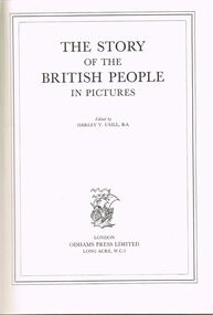
Book - LYDIA CHANCELLOR COLLECTION: THE STORY OF THE BRITISH PEOPLE IN PICTURES
Lydia Chancellor Collection - Book-The Story of the British People in Pictures '512 pages with nearly 700 illustrations .Hard covered blue cover with gold printing / paper dust cover showing price of seven shillings and six pence , / edited by Harley Verneau Usill , BA / London Press Ltd , Long Acre , WC2t.books, collections, history, lydia chancellor collection, collection, - -the story of the british people in pictures edited by harley v usill , ba / london press ltd , long acre , wc2, history, britain, british history -
Bendigo Historical Society Inc.
Map - CAMPBELL COLLECTION: BENDIGO AND DISTRICT MAPS, 23-4-29
Map. Whirrakee, Parish of Whirrakee, Total area 4419 acres, scale 20 chains to 1 inch. Unused water race in centre of map. Eucalypt Oil Distillery, bottom of map. Prepared in W.P.B. from Assessor's Plan and Parish Plan. G.W.Latimer 23-4-29. (number 385 in map cupboard 1)G.W.Latimermap, bendigo, agricultural lands -
Whitehorse Historical Society Inc.
Document, Mitcham, St John's cemetery, 1/10/1975
Information from notes at La Trobe Library by Ringwood Historical Research Group. St John's Mitcham now stands on Mitcham's first school and graveyard. One acre of land was presented to the school by John McGlone. In 1948 the church was declared unsafe by the Victorian Health Commission. In 1952 bodies were exhumed and re-interred.st johns catholic church, mitcham, kranewitter, aloysius, fr., mcglone, john -
 Bendigo Historical Society Inc.
Booklet - Schild's Catalogue
Mid-1910s Booklet of fancy-dress costumes, supplied by M. Miller LondonSchild's Fancy Costumes for Ladies & Gentlemen. 42-page booklet of fine range of sketches of fancy-dress costumes. Supplied by M. Miller London, 142, Long Acre W.C. 2. Noting special appointment to the late King Edwaard VII - circa mid-1910s. Black print on beige paper/pages, stapled.fancy dress costumes, 42-page booklet of sketches of fancy dress costumes -
 Whitehorse Historical Society Inc.
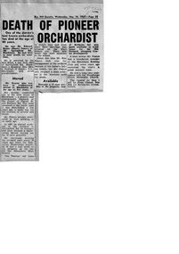
Article, Death of Pioneer Orchardist, 10/05/1967
Edward Henry (Harry) Pearce died in April 1967non-fictionEdward Henry (Harry) Pearce died in April 1967pearce harry, pearce edward h, springfield road blackburn no.106, blackburn high school, lend lease development, blackburn bowling club, woodhouse grove methodist church, old orchard shopping centre -
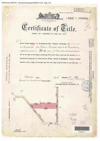 Ringwood and District Historical Society
Document, Certificate of Title - Harold Claude Howship, Nurseryman, Ringwood, Vic. - 1928
A4 copies of Landata Victoria Historical Search documents - Vol 5485 Fol 1096804. Harold Claude Howship of Mt. Dandenong Road Ringwood, Nurseryman, is now the proprietor of an Estate in Fee-simple subject to the Encumbrances notified hereunder ... 5 acres 3 roods 10 perches or thereabouts, part of Crown Section Twenty, Parish of Warrandyte, County of Evelyn, together with a right of carriage way over roads coloured brown. Subdivision map includes Wonga Road (later Warranwood Road), Grandview Grove (later Bemboka Road), and Plymouth Road, Ringwood. Proprietors and Transfers include Emily Mills, Plymouth Road Ringwood, Widow - 27th January, 1939. William George Carter, Grandview Grove Warranwod - 14th March, 1947 - 3 acres Evelyn Goudie and Beverley Gwen Goudie, Wonga Road Warranwood - 23rd October, 1950 - 1 acre -
Glenelg Shire Council Cultural Collection
Certificate - Share Certificate - Pine Plantations, c. 1950
Share certificate: Pine Plantations Pty. Ltd. Plantation Portland No. 7. Issued to John Seymour Dening of Matcham via Gosford NSW. One acre portion, £100. No. 471. Butt coloured paper, orange patterned border, orange illustration of forest and figure with torch & shield bearing Australian coat of arms, in centre of share certificate. -
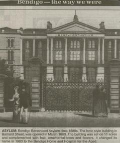 Bendigo Historical Society Inc.
Newspaper - JENNY FOLEY COLLECTION: ASYLUM
Bendigo Advertiser ''The way we were'' from 2000. Asylum: Bendigo Benevolent Asylum circa 1880s. The Ionic style building in Barnard Street was opened in March 1860. The building was set on 11 acres and complemented with fruit, ornamental trees and flowers. It changed its name in 1963 to the Bendigo Home and Hospital for the Aged. The clip is in a folder.newspaper, bendigo advertiser, the way we were -
Bendigo Historical Society Inc.
Map - CAMPBELL COLLECTION: BENDIGO AND DISTRICT MAPS
Map. Ascot, Parishes of Huntly, Sandhurst and Wellsford. Scale 20 chains to 1 inch. Total area 2818 acres. To Bendigo 4 1/2 miles, to Epsom 3/4 mile, Huntly 3/4 mile. Prepared in W.P.B. from Assessment Plans and Parish Plans. (number 380 in map cupboard 1)map, bendigo, agricultural lands -
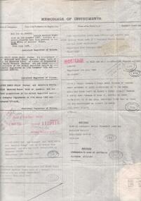 Bendigo Historical Society Inc.
Document - TITLE OF LAND AXEDALE
Land title Vol. 3730 Fol. 745810. On the fifth of April Edward Patrick Drake of Axedale hotelkeeper paid 6 pounds for one acre more of less being allotment four of section seven in the town of Axedale, parish of Axedale County. On the other side the names and dates of when the land changed hands up to July 1976.axedale, history, drake family -
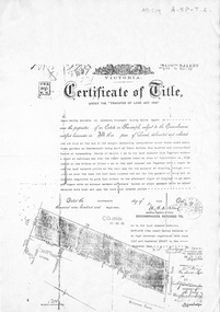 Whitehorse Historical Society Inc.
Document, Certificate of Title, 19/07/1918
Photocopy of Certificate of Title Vol. 4156 Folio 831198 for 43 acres Fronting on Canterbury Road near Mitcham Road, being part of Crown Portion 124, Parish of Nunawading, County of Bourke in the name of James Harley Malcolm, 19/7/1918. Last subdivision dated 22/5/1926- current site of Glenburnie Roadland subdivision, malcolm, james harley, mitcham road mitcham, glenburnie road mitcham, canterbury road mitcham, various surnames -
 Bendigo Historical Society Inc.
Document - LANDS OFFICE - SALE OF CROWN LANDS - 1864 - 1869, 1864- 1869
Journal: LANDS OFFICE - SALE OF CROWN LANDS - 1864 - 1869 Brown hard cover journal. Contains details of sales of crown land, listed in chronological order of sales. Includes lot, allotment, section, county, parish, area, upset price per acre, deposit, amount for which sold, valuation, name of purchaser. On spine 011Lands Officelands office, crown land, crown land sales, land sales, bendigo, sandhurst -
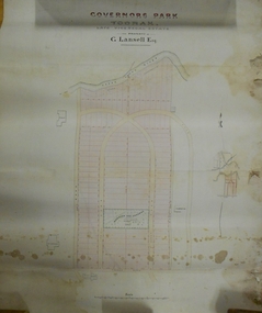 Bendigo Historical Society Inc.
Plan - MARKS COLLECTION: PLAN OF G. LANSELL'S GOVERNOR'S PARK, TOORAK
Plan (tightly rolled) drawn on heavy paper mounted on fabric. On top of plan printed 'Governor's Park Toorak, late Vice-Regal Estate, the property of G. Lansell Esq' On top of plan Yarra River, on bottom Toorak Road, Plan shows subdivision, in centre of which is drawn outline of 8 acres containing the 'Mansion and Grounds'.bendigo, hospital -
Eltham District Historical Society Inc
Folder, James Johnston
"Johnston, James - Kangaroo Ground, is a scotchman by birth, born in Aberdeenshire in 1812. Arriving in Melbourne in 1840, and spending twelve months on the Plenty, and another similar period on the Darebin Creek, he went in 1842, to the Kangaroo Ground, where he rented a farm from Mr Donaldson for seven years, subsequently purchasing 160 acres of land from the Government at one pound 13s per acre, and also owning 60 acres adjoining, where he carries on farming. Mr Johnston has a family of three sons and four daughters." Sutherland, Alexander Victoria and its Metropolis, v.2 1888 page 434. Folder of information on James Johnston, Kangaroo Ground pioneerjames johnston, pioneer, kangaroo ground -
 Eltham District Historical Society Inc
Photograph, Allwood Nurseries, Diamond Creek, Vic
Allwood Nurseries in Hurstbridge was operated by W.G (William George) Gray. By 1922 he operated a well cultivated property of 64 cleared acres, 56 of which were under nursery healthy stock, principally apples, peaches, plums and cherries. In addition to 4 acres of potatoes. He grew seedling stock which he supplied to other local orchardists and the overseas market. This photo forms part of a collection of photographs gathered by the Shire of Eltham for their centenary project book, "Pioneers and Painters: 100 years of the Shire of Eltham" by Alan Marshall (1971). The collection of over 500 images is held in partnership between Eltham District Historical Society and Yarra Plenty Regional Library (Eltham Library) and is now formally known as 'The Shire of Eltham Pioneers Photograph Collection.' It is significant in being the first community sourced collection representing the places and people of the Shire's first one hundred years.Digital imagesepp, shire of eltham pioneers photograph collection, hurstbridge, allwood nurseries, export, nursery -
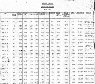 Bendigo Historical Society Inc.
Document - STATE RIVERS AND WATER COMMISSION : COLIBAN DISTRICT WATER DISTRIBUTION ACRE FEET
A table titled Coliban District Water Distribution Acre Feet. The dates indicated cover the period 1937-1957. Main column headings: Urban Supplies, Irrigation, Sluicing, Total Consumption, Total Deliveries from Storages, Loss, Efficiency, and Remarks. Years and figures are typed in red columns with some figures totalled in pencil at the bottom of the last column.state infrastructure, water supply, coliban system, state rivers and water supply commission. coliban system.