Showing 1400 items
matching allotments
-
 Ringwood and District Historical Society
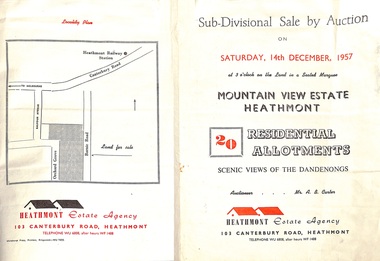
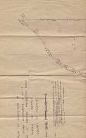
Flyer - Land Sales Brochure, Sub-Divisional Sale by Auction - Mountain View Estate, Heathmont, Victoria - 1957
Bi-fold pamphlet advertising auction of 20 residential allotments on Saturday, 14th December, 1957, with description of services available and finance terms. Subdivision inclues Orchard Grove and Barnic Road. Agent - Heathmont Estate Agency, 103 Canterbury Road, Heathmont, Telephone WU6808, after hours WF1488. Auctioneer Mr. A.B. Carter. Accompanying Parish of Ringwood survey map with cardboard backing - Part of Crown Allotment 14B, includes handwritten price notations for each allotment. -
 Warrnambool and District Historical Society Inc.
Subdivision plan, Part of Preston Estate Parish of Wappan
This map possibly relates to land of John Bostock at Preston, Delatite. Part of a collection of papers relating to the Bostock family one of the earliest pioneering families in Warrnambool.Cream coloured map printed in black with sections coloured in pink. Plan of subdivision of part of crown allotments 15 and 17 and part of Preston pre- emptive right, Parish of Wappan, County of Delatite.warrnambool,bostock,augustus bostock map, delatite map,district of wappan map, -
 City of Moorabbin Historical Society (Operating the Box Cottage Museum)
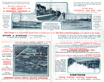
Flyer - Moorabbin Electric Station Estate, Moorabbin, 1925
The train line from the city to Frankston was electrified which intensified the sale in the municipality of Moorabbin, particularly land which was in the vicinity of the railway stations.Example of the progress of the Municipality of MoorabbinAdvertising flyer for auction of real estate sales - plan of building blocks for saleMoorabbin Electric Station Estate, Moorabbin - Auction Saturday 30 May 1925 - 65 Residential allotments Auctioneer Knight & Harwoodmoorabbin station, south road, station street, jasper street (now redholme street), central avenue, moorabbin, real estate, auction -
 Ringwood and District Historical Society
Document - Folder, Kinton Court Estate Subdivision, Ringwood, Victoria - 1975
Manilla folder containing plan of residential subdivision, with price list and summary of services available. Subdivision includes Oban Road, Jeffrey Drive, Flora Court and Kinton Court. Timbered land - 22 sewered allotments. Agents - C.E. Carter & Son RESI., 122 Whitehorse Road, Ringwood (Phone) 8706211. -
 Ringwood and District Historical Society
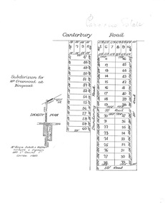
Plan, Paradise Estate Subdivision, Ringwood, Victoria - circa 1925
Paradise Estate layout also included in Land Sale Brochure Titled Eureka Plan Book - Seven Delightful & Valuable Ringwood Estates - circa 1925, Reg. No. 5100.Subdivision plan of Paradise Estate, Ringwood, showing allotments for sale, with typed page attached showing block sizes and prices.Locality plan showing land for sale south of Canterbury Road, 1 Mile south of Ringwood Railway Station. Subdivison includes Canterbury Road and Dandenong Road (later Wantirna Road). Surveyors - McKenzie Aisbett & Webber, surveyors & engineers, 440 Little Collins Street, Melbourne, Telephone Central 11540. Subdivision for Mr Grenwood at Ringwood. Additional typewritten price list showing footage, price per foot, and price per block for Lots No. 1 to 60. Paradise Estate layout also included in Land Sale Brochure Titled Eureka Plan Book - Seven Delightful & Valuable Ringwood Estates - circa 1925, Reg. No. 5100. -
 Ringwood and District Historical Society
Flyer, Land Sale Advertisement - Roebury Estate, Ringwood, Victoria - circa 1938
Advertisement for sale of residential allotments with map showing location and layout of subdivision, terms of sale, and summary of local features and services.Subdivision includes Dublin Road, Alexander Road, and Ferntree Gully Road (later Bedford Road). Agent - J.B. McAlpin, Opposite Railway Station, Ringwood. -
 Ringwood and District Historical Society
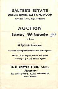
Flyer, Land Sale Auction Brochure, Salter's Estate, East Ringwood, Vic. - 1956
Folded single page advertising auction of allotments on Saturday, 10th November (1956), including layout of subdivision and terms of sale.Subdivision includes Railway Avenue, Nicholson Street, Althol Grove (later Morcom Avenue), Illoura Avenue, Tweed Street, Merry Street, and Dublin Road. (Agent) C.E. Carter & Son R.E.S.I., Auctioneer, 126 Whitehorse Road, Ringwood, Phone WU6024. -
 Federation University Historical Collection
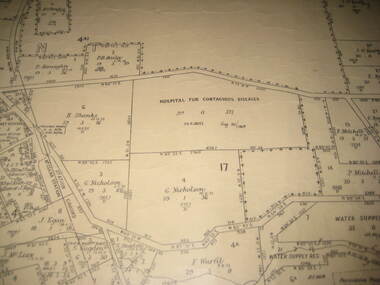
Plan - Plan - Cadastral, Parish of Ballaarat - Sheet 3 (only), 03/03/1932
Sheet 3 of the Parish of Ballart showing Government roads, crown allotments, dimensions, crown grantees, date of grants, etc,ballarat, plan, hospital for contagious diseases, sebastopol, sebastopol rifle range, fiscalini, leigh river, yarrowee creek -
 Bendigo Historical Society Inc.
Map - GRAZING ALLOTMENTS, 15/10/1894
Map: Grazing Allotments, Parishes of Whirrakee and Bagshot, County of Bendigo. Parish plan (number 331 in map cupboard 1)map, bendigo, grazing allotments, grazing allotments, whirrakee, bagshot -
 Whitehorse Historical Society Inc.
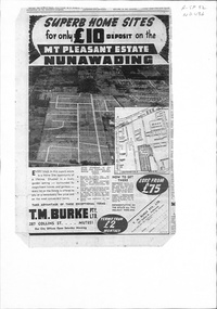
Document, Mount Pleasant Estate, ca 1953
Plan and advertisements for 'Mt Pleasant Estate' Forest Hill. 381 allotments. Agent: T. M. Burke Pty Ltd.land sales, mount pleasant estate, rooks road, vermont, canterbury road, forest hill, alwyn street, mitcham, diosma crescent, nunawading, nott street, eugenia street, abelia street, weigela court, nandina street, grevillea court, azalea street, felicia grove, beech street -
 Lakes Entrance Historical Society
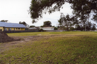
Photograph, 2008
Date made August 2008Colour photograph of a vacant allotment which was the site of the old All Nations hotel, Palmers Road, Lakes Entrance, Victoria.hotels, vegetation, room display -
 Linton and District Historical Society Inc
Mining survey document, Mining Survey Document, 1890
Document drawn up in relation to an application for a mining lease made by Isaac Walker of Linton. Application no. PP16, Lease no. 1351. Application was made for a mining lease on land in Sussex Street, Linton, which was occupied by Sarah Dawe and family. Original document is held at PROV Ballarat. Item and series details are recorded in handwriting on the lower part of the document.Photocopy of original document, which shows a plan of Allotments 3 & 4, Section 1A, Township of Linton, Parish of Argyle.mining applications, mining leases, plans, documents, isaac walker, dawe family, sarah dawe née carpenter -
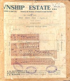 Ringwood and District Historical Society
Map, Two Partially Trimmed Copies of Ringwood Township Estate subdivision advertisement - 1919
Clippings on cardboard backing. Handwritten sales notations on numbered allotments in Ellison Street, Haig Street and Wantirna Road, Ringwood.One copy includes three oval rubber stamp impressions - F. Parker, Estate Agent, Ringwood. -
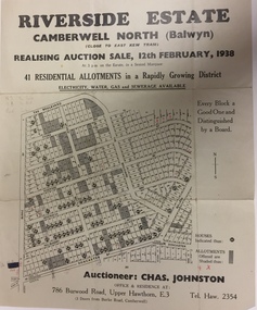 Kew Historical Society Inc
Plan - Subdivision Plan, Riverside Estate, Camberwell North (Balwyn), 1938, 1939
This subdivision known as the Riverside Estate wa sone of the largest and most significant in Balwyn's history.Subdivision Plan for 41 lots within the wider Riverside Estate in Camberwell North, now Balwyn, in February 1938. The auction featured lots in Burke Road, The Boulevard, Mt View Road, Wattle Avenue, Kyora Parade, Cascade Street, Riverside Avenue, Walbundry Avenue, Inverness Way, Bulleen Road and Doncaster Road.Allotments for sale are shaded grey on the map. Certain lots have an H in a circle. These are presumably where houses had already been constructed.subdivision plans - balwyn (vic), riverside estate - balwyn (vic) -
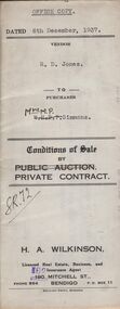 Bendigo Historical Society Inc.
Document - H.A. & S.R. WILKINSON COLLECTION: CONTRACT OF SALE
Conditions of sale by private contract dated 6th December, 1937 between R.D. Jones (seller) and Mrs. M.P. Simmons (buyer) for land situate in Thisle Street, Bendigo, being part of Crown allotment 17 section 17B described in conveyance no. 793, book 555, part of Crown allotment 18A described in certificate of title volume 6145 folio 1228836. Also the south eastern portion of allotment 18 section 17B described in residence area No. 7757. Price 120 pounds. Office copy.organization, business, h.a. & s.r wilkinson real estate -
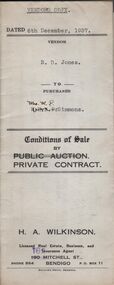 Bendigo Historical Society Inc.
Document - H.A. & S.R. WILKINSON COLLECTION: CONTRACT OF SALE
Conditions of sale by private contract dated 6th December, 1937 between R.D. Jones (seller) and Mrs. M.P. Simmons (buyer) for land situate in Thisle Street, Bendigo, being part of Crown allotment 17 section 17B described in conveyance no. 793, book 555, part of Crown allotment 18A described in certificate of title volume 6145 folio 1228836. Also the south eastern portion of allotment 18 section 17B described in residence area No. 7757. Price 120 pounds. Vendor's copy.organization, business, h.a. & s.r wilkinson real estate -
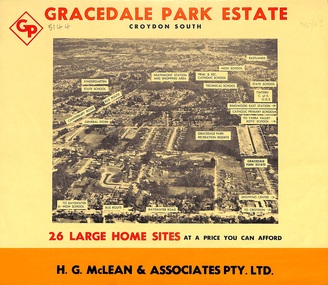 Ringwood and District Historical Society
Flyer, Land Sale Brochure, Gracedale Park Estate, Croydon South, Vic. circa 1968
Although the brochure advertises Gracedale Park Estate as Croydon South, the home sites and streets are in the 3135 postcode area, i.e. Ringwood East/Heathmont.Bi-folded orange coloured sheet with black print advertising sale of residential allotments, including subdivision features and local facilities.Sudivision includes Ringwood East streets - Gracedale Avenue and Raymond Court. Agent - H.G. McLean & Associates Pty. Ltd., 166 Canterbury Road, Heathmont. Telephone 870 3422, A/Hours 870 5879, 729 2809. -
 Warrnambool and District Historical Society Inc.
Original Document, Map: Agricultural area of Ballangeich 1865, 1865
George Eddington arrived in Australia in 1839 and named and established property in 1841 calling the property Ballangeich after a Pass near his home town of Stirling in Scotland. It is situated 151 miles west of Melbourne and to the south of Mortlake and was originally part of the Mortlake shire, which was proclaimed 26th Jan 1864. Nearest streams are the Hopkins Riverand Lyall and Drysdale creek running through good agricultural land. This map relates to the breaking up of large runs which the Victorian government enabled through selection acts of the 1860's. The previously larger runs which were mainly cattle and sheep based were now more open to closer settlement and a greater variety in farming.The lots range in size from approximately 50 acres to around 600 acres.Some areas are set aside for reserves. By 1886 the population of Ballangeich had grown to around 600 with an hotel, three state schools and a church.Tri weekly coaches ran to Colac, Warrnambool and Camperdown providing access to supplies mail and communication. This map is typical of many which were produced in the 1860's in Victoria during a significant period of Victoria's and Warrnambool district history.Rectangular light card paper with black text showing allotments of land The area is coloured in green with scale at bottom right cornerAt the top: Plan of the Agricultural area of Ballangeich 1865 At the bottom left: Prepared by the Board of Lands & Works in accordance with the Amending Land Act 1865 Lands & Survey Office Melbourne 13th April 1865. With signaturehistory of warrnambool, ballangeich, land surveys victoria 1865, lands act 1865 victoria, ballangeich map 1865 -
Bendigo Historical Society Inc.
Map - LOCKWOOD, November 25th 1855
Map: Garden Allotments within the Town Reserve of Lockwood on the Bullock Creek. Parish plan (number 273 in map cupboard 1)map, bendigo, parish plan, lockwood, garden allotments, bullock creek -
 Peterborough History Group
Map - Shire of Warrnambool
Map of the area, when Peterborough was part of Warrnambool ShireHistoric map of the area when Peterborough was in the Warrnambool ShireA3 size map, larger view of the whole shire of Warrnambool, and includes adjoining Shire Boundaries. Shows individual land allotments.peterborough, warrnambool shire, old maps -
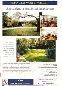 Whitehorse Historical Society Inc.
Document, 26 Penllyne Avenue, Vermont, 1/06/1998 12:00:00 AM
Auction brochure 26 Penllyne Avenue,Auction brochure 26 Penllyne Avenue, Vermont. Large allotment, brick veneer home auction June 1998. Built 1954.Auction brochure 26 Penllyne Avenue,auctions, penllyne avenue, vermont, no 26, cody first national real estate -
Canterbury History Group
Pamphlet - Ye Heights of Canterburie; Ye Star of the Eastern Suburbs, 1887
Photocopy of brochure advertising sale by auction of ' 70 Business and Villa sites' in Canterbury on 10 December 1887.Includes map of the allotments.canterbury, canterbury road, church street, highfield road, margaret street, land subdivision, flint> f.l, auctioneers -
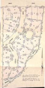
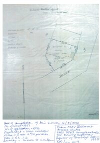
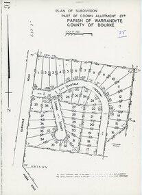 Ringwood and District Historical Society
Map - Plan of Subdivision, Part of Crown Allotment 27B Parish of Warrandyte County of Bourke (undated, circa 1970)
Photocopied subdivision map of 38 residential allotments in Glenvale Road, Cantala Crescent, and Giana Court, north of Kubba Road, Ringwood. -
 Bendigo Historical Society Inc.
Legal record - FEATONBY Mrs Anne - Sale Note, Watson, James & Rogers, Rogers Collection, 10.02.1920
In the early 1980s the firm of Watson, James & Rogers merged with the partnership of Every & Every and became the iconic “Rogers & Every” as known today. The firm is still located on Bull Street. https://rogersevery.com.au/about/FEATONBY, Mrs Anne Sale note re Crown Allotment 4, Parish of Warriwitue County of Dalhousie. Cream coloured paper.Signatures.sale note, sherriff, featonby, public auction, land sale, nicholas kennedy -
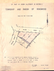 Ringwood and District Historical Society
Document - Plan of Subdivision, Part of Crown Allotment 25 Section E, Township and Parish of Ringwood - 1961
Map showing residential allotments numbered 1, 2, 3 and 4, on Wilson Street and Braeside Avenue, Ringwood East, Victoria.Signed and dated 1/12/1961. Rubber stamped Kirkpatrick & Webber, Licensed Surveyors, Civil Engineers & Town Planners, 225 Maroondah Highway, Ringwood, Telephone 870-0321. Ref 3438C. "Note: Lot 4 is to be transferred to the Registered Proprietor of Lot 2 on Lodged Plan 23477 and is to be consolidated therewith." Map also includes handwritten Estate Agent notations. -
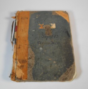 Bendigo Historical Society Inc.
Administrative record - Application for allotments for sale 1908-1974
Green cover book with brown leather spine. The book lists the applications for allotments of land for sale. The headings in the book are: number of application, date of registry, date of application, surname, Christian name and address, parish, allotment, section, area, local land board schedule, classification, crown grant, references and remarks. It covers the years 1908 -1974.Spine has a red label with gold letters. On the cover the remnants of a label, under in ink Sec.173, 1011-3420. At top left of the cover Sec.171 SHland sales, govrnment -
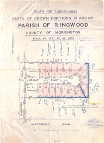 Ringwood and District Historical Society
Map - Plan of Subdivision, Parts of Crown Portions 10 and 10B Parish of Ringwood - 1958
Folded subdivision map of 15 residential allotments in McKay Court Ringwood, off Wantirna Road north of Canterbury Road. Rubber stamped by Surveyors and Chartered Engineers J.S. Watson & Associates, Mornington and South Yarra, with illegible signature dated 17/2/58. Handwritten notations indicating allotment sale names and amounts or where passed in.Scale 80 feet to an inch. -
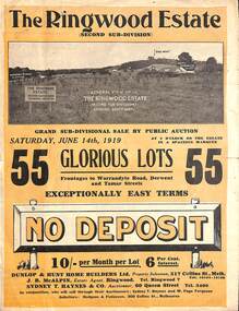 Ringwood and District Historical Society
Pamphlet - Land Auction Brochure, The Ringwood Estate - Second Sub-Division, Ringwood, Victoria - 1919
Double sided bi-fold leaflet advertising subdivision site, layout of streets and allotments, summary of local features and services and terms of sale. Auction Saturday June 14th, 1919. 55 Lots. Subdivision includes Warrandyte Road, Tamar Street, Mersey Street and Derwent Street. Property Sales - Dunlop & Hunt Home Builders Ltd., 317 Collins Street, Melbourne, Tels 10104-10105. Agents - J.B. McAlpin, Tel. Ringwood 7. Auctioneers - Sydney T. Haynes & Co., 60 Queen Street, Melbourne, Tel. 3400. Solicitors - Hodgson & Finlayson, 360 Collins Street, Melbourne. Inset photographs of local views including existing 4-roomed bungalow on Lot 37 Tamar Street. -
Clunes Museum
Map - MAPS
A MAP OF CLUNES TOWNSHIP. ORIGINAL AND COPY. ALL STREETS WITH ALLOTMENT NUMBERS CRESWICK CREEK - KILKENNY CREEK - BALLARAT TO MARYBOROUGH RAILWAY LINE.CLUNESlocal history, document, maps, clunes township -
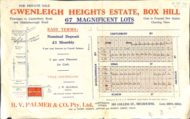 Whitehorse Historical Society Inc.
Document, Gwenleigh Heights Estate, Box Hill, unknown
Land plan of 67 allotments for sale between Canterbury Road, Middleborough Road and Agnew Street, Box Hill. (Now Blackburn South)land subdivision, middleborough road, blackburn south, canterbury road, agnew street, aberdeen road, h. v. palmer (estate agent)