Showing 15861 items
matching areas
-
 Vision Australia
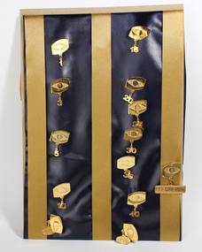
Badge - Object, Vision Australia Foundation milestone badges, 2000-2003
To honour the commitment of its staff, badges were awarded to commemorate years service. These consisted of the Vision Australia Foundation symbol of an eye (flat surface for the iris and areas immediately below and above the eye, and roughened surface for the background of the iris), in gold. A number reflecting the years of service was attached by a loop below the badge in gold. Service was commemorated at the 1st, 3rd, 5th, 10th, 15th, 20th, 25th, 30th, 35th and 40th year. Life Governor, Area Leader and Friend could also be attached to the badge. Metal pin of an eye with attachments1, 3, 5, 10, 15, 20, 25, 30, 35, 40, Life Governor, Area Leader, Friendvision australia foundation, badges -
 Mt Dandenong & District Historical Society Inc.
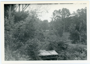
Photograph, View from George Barber's Home To His Stables
John Lundy-Clarke grew up in the Kalorama/Mt Dandenong area and later in life (1972-74) began to write a comprehensive history of the area working from an original settlement map in an effort to cover all areas. This photograph was taken by John Lundy-Clarke in 1973 to show changes to the environment sine 1905.Black and white photograph with tangled bush and small shed in foreground looking towards a cleared area. Handwritten description on reverse written by John Lundy-ClarkeView from Barbers drive to his stables close to where 1905 picture was taken. Stables in foreground. Looking towards Gap. Taken JLC November 1973.barbers road, john lundy-clarke, kalorama -
 Bendigo Military Museum
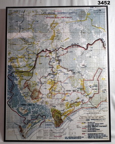
Map - MAP, MOUNTED VIETNAM, C. Late 1960’s
Australian area of Operations.Map of Phuoc Tuy Province showing civilian access areas in colour. Laminated surface on board backing with black border &mall hanging strap on back.Top centre: “UNCLASSIFIED. LATE SPECIAL OVERPRINT (SHEET 1)map, vietnam -
 Whitehorse Historical Society Inc.
Document, Colombo Street Buildings, 1/06/2004 12:00:00 AM
Detailed plans and drawings of proposed multi-storey buildings for Colombo Street, Mitcham.Detailed plans and drawings of proposed multi-storey buildings for Colombo Street, Mitcham. Also includes photos of Mitcham area around the buildings.Detailed plans and drawings of proposed multi-storey buildings for Colombo Street, Mitcham.colombo street, mitcham, mitcham, whitehorse road, mitcham, mitcham railway station, st johns catholic church, mitcham, station street, mitcham, high rise buildings -
 Stawell Historical Society Inc
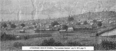
Drawing, Town & Big Hill from King Street area -- Sketch
Town & Big Hill from King Street areaBlack and White sketch drawn from King Street area St Patrick's church just right of centre. Poppet heads on skyline. A Panoramic View of Stawellstawell -
Whitehorse Historical Society Inc.
Map, State Electoral Map, 1926
State Electoral Map for 1926.State Electoral Map: Metropolitan and country areas, showing changes to electoral districts legislated in the Redistribution of Seats Bill 1926State Electoral Map for 1926.victoria, electoral boundaries -
 Vision Australia
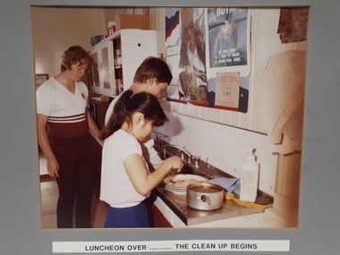
Photograph - Image, Two teenagers washing up
A male at a kitchen sink, tap running and starting to wash up. Next to him, closer to camera, a female has her hand over some scraped plates that sit next to a soaking saucepan. Another male approaches the sink area from the far side. Poster hang above the sink, whilst to the left of the sink are white overhead cupboards holding kitchen items and below the white bench top are dark orange cupboard doors. Between the two males, there is possibly a microwave. Below the picture are the words "Luncheon over ... the clean up begins".Digital image of three people in a kitchen arealife skills, rvib burwood school -
 Vision Australia
Photograph - Image, Braille and Talking Book Library garden
Adjacent to the Braille and Talking Book Library was a small garden area. In this image, the park bench to the far left sits behind the fence facing Commercial Road.Lawn area with medium sized tree in the centre and two parks benches some distance either sidebraille & talking book library, robert de graauw -
 Kiewa Valley Historical Society
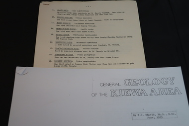
Information on Geology, Flora, Birds of the Kiewa Area, C1960
Information of the Kiewa area commissioned by the State Electricity Commission of Victoria for use by the general public.To inform the interested public, visiting the Kiewa area, about the Geology, Flora and birds as documented by various professionals and commissioned by the State Electricity Commission of Victoria.1. Foolscap x 4 sheets, numbers 11-80 list of birds and description 2. A4 size x 4 sheets "Birds of the Bushland" 3. A4 size x 4 sheets "The Three Floras of Bogong" 4. A4 Size x 4 sheets "General Geology of the Kiewa Area" 1. -2- centre top of first page. List of birds 11-27. …/3 bottom Rt. hand corner of top page 2. Photocopied sheets, printed on Rt. side of paper only. Heading is "BIRDS of the BUSHLAND" followed by diagrams and name of 13 birds. Photocopied using right half of paper only. 3. 'THE THREE FLORAS OF BOGONG' inside a rectangular box. Midway down page 'Published by the State Electricity Commission of Victoria" and towards bottom of page 'October, 1964'. Both inscriptions inside a rectangular box. Photocopied using right half of paper only. 4. photocopied sheets on right side of paper only, GENERAL GEOLOGY OF THE KIEWA AREA by F>C> Beavis, Ph.D., B.SC. June, 1963. 4.flora; geology; birds; kiewa area; secv; tourism; environment -
Clunes Museum
Map, DJA DJA WARRUNG RECOGNITION AND SETTLEMENT AGREEMENT AREA, 2013
MAP DJA DJA WURRUNG RECOGNITION AND SETTLEMENT AGREEMENT AREACOLOUR PRINTED MAP LAMINATED. SHOWING THE DJA DJA WURRUNG RECOGNITION AND SETTLEMENT AGREEMENT AREA SUBJECT TO RECOGNITION AND SETTMENT AGREEMENT 2013dja dja wurrung, map of recognition area -
 Lara RSL Sub Branch
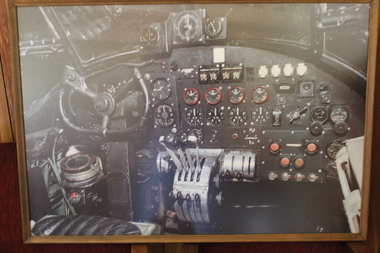
Picture Lancaster Bomber Instrument Panel, Lancaster Bomber Instrument Panel S for Sugar R5868
Heavy 4 engines Avro-Lancaster Bomber - piIot area and instrument panel in service with R.A.F. during World War II. Registration S for Sugar R5868.World War 2 , heavy 4 engined Bomber Registration Number S for Sugar R5868 maintained at R.A.F. Museum Hendon U.K.Rectangular shaped color print of the interior of a Lancaster Bomber showing the pilots area and aircraft instrument cluster. Rear of the frame is a small strip stating photograph by Tony Watts - title - "After the Battle magazine. Lancaster Cockpit - that of R5868 at the RAF museum, Hendon U.K. Sticker - GEELONG PICTURE FRAMERS - Art Posters . Prints . Framing 70 Ryrie Street, Geelong- Telephone - (052) 29 7805world war two, avro lancaster bomber, r5868 -
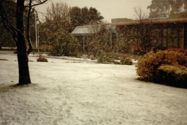 Hume City Civic Collection
Photograph, 1/08/1986
A series of photographs were taken when heavy snow fell in Sunbury in August 1986. The snow began falling overnight and remained on the ground for 24 hours. Snow fell across the metropolitan area during that 24 hour period in a very unusual event for the area.A coloured photograph of the front of the former Shire of Bulla Council Offices and front garden during a snow storm. The lawn area is covered with snow.snow falls, weather patterns, shire of bulla council offices, sunbury police station, george evans collection -
Whitehorse Historical Society Inc.
Article, Aspects of local shops, 2013
Talk by Gerry Robinson to a General Meeting of Whitehorse Historical Society on 10 August 2013.Talk by Gerry Robinson to a General Meeting of Whitehorse Historical Society on 10 August 2013 on shopping from village to internet in eastern areas of Melbourne.Talk by Gerry Robinson to a General Meeting of Whitehorse Historical Society on 10 August 2013.shops, heathmont, ringwood, canterbury road, robinson, gerry, whitehorse historical society inc -
Marysville & District Historical Society
Ephemera (Item) - Information brochure, Artworkz Tourism, MARYSVILLE-YELLOW DOG DAY VISITOR AREA, 23-04-2018
An information brochure on the Yellow Dog Day Visitor Area near Marysville. This brochure was produced by Artworkz Tourism in April 2018.An information brochure on the Yellow Dog Day Visitor Area near Marysville.Disclaimer: The authors have taken care to ensure this/ publication is correct, though please be aware that/ errors and omissions do occur.marysville, victoria, australia, information brochure, artworkz tourism, yellow dog day visitor area -
Whitehorse Historical Society Inc.
Map, Yarra River, 1839
Copy of T.H. Nott's original survey of 'Yarra Yarra River' taken from 'Lilydale' by Grace Aveling.Copy of T.H. Nott's original survey of 'Yarra Yarra River' taken from 'Lilydale' by Grace Aveling. Covers area from Templestowe to Yarra Glen.Copy of T.H. Nott's original survey of 'Yarra Yarra River' taken from 'Lilydale' by Grace Aveling. maps, yarra river -
 Greensborough Historical Society
Photographs, Photographs by Maria Barbaro, 2009_
A collection of over 170 photographs taken by artist Maria Barbaro as studies for her paintings. Taken in the Greensborough area, photos cover a wide range of natural and built landscapes, including the Plenty River; parks and gardens; the Greensborough Hotel; Ashmead; Greensborough railway station.A variety of photographs of the Greensborough area in the early 21st Century.Folder containing approx 150 colour photographs of Greensborough area. Each photograph 10x15cmmaria barbaro, greensborough -
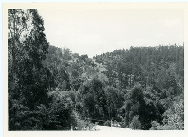 Mt Dandenong & District Historical Society Inc.
Photograph, View From Doughty's Road 1974
John Lundy-Clarke grew up in the Kalorama/Mt Dandenong area and later in life (1972-74) began to write a comprehensive history of the area working from an original settlement map in an effort to cover all areas. This photograph shows approximately the same area as photograph number KAL0193 but is taken 60 years later. The trees have grown much taller and the buildings changed. On the site of the Paynter house 'Iona' there is now the 'Yosemite' (Villa Toscana) accommodation. The pavilion in the centre of the photo is the site of 'Kalorama', home of early pioneer Isaac Jeeves. The photograph is taken looking up towards The Gap (FiveWays).Black and white photograph showing a forested area with clear sites. Roofs of buildings can be clearly seen. Handwritten inscription on reverse by John Lundy-ClarkeView from near Doughty’s Rd looking north up valley to Kalorama Gap in Jan 1973. Tiny roof in centre is pavilion on site of “Kalorama”. Long roof to its left is Yosemite Motel on site of “Iona”.paynter, kalorama, iona, yosemite, villa toscana, five ways, the gap -
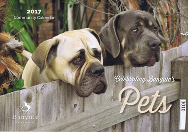 Greensborough Historical Society
Calendar, Banyule City Council, Banyule Community Calendar 2017: celebrating Banyule's pets, 2017_
This community calendar is distributed to residents of the City of Banyule each year. Each year it focusses on an aspect of the local community. The 2017 calendar contains photographs of pets from the local area. Some council services are detailed in the back pages.The annual report is a record of the activities and services in the Banyule City Council area.28 pages. Colour illustrations. Illustrations of local sporting clubs in pets from the local area.banyule city council, banyule community calendar -
Whitehorse Historical Society Inc.
Document, Heritage Place report
Report on 18 The Avenue Blackburn, built by local builder Algernon Elmore.Report on 18 The Avenue Blackburn, built by local builder Algernon Elmore. Heritage Overlay No. HO209 Contains history of the former 'Kings Paddock' area.Report on 18 The Avenue Blackburn, built by local builder Algernon Elmore.kings paddock blackburn, elmore houses, elmore, algernon john, the avenue, blackburn, no. 18 -
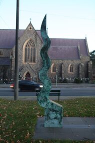 City of Ballarat
Public Artwork, Eternal Flame by Peter Blizzard, 1995
Eternal Flame was created by Ballarat sculptor Peter Blizzard as a marker of the end of WWII in the Pacific. Engraved into the bluestone shaped tile across the base of the statue is details about conflict areas where Australian Troops were active. The metal structure mimics a moving flame with it's polished golden hue, a feature included in many war memorials around the world. Peter Blizzard also designed the Prisoner of War Memorial in the South Gardens, Ballarat Botanic Gardens. The metal structure mimics the moving flame of polished golden hue that is present in war memorials around the world. Eternal flame is aesthetically and historically significant to the people of BallaratMetal construction on bluestone tile baseConflict areas for Australian Troops are engraved into bluestone shaped tile across the base of the statue. eternal flame, world war ii, conflict, peter blizzard, australian sculpture -
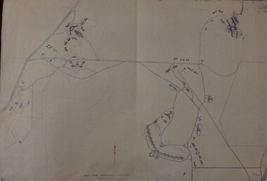 Greensborough Historical Society
Maps, Mont Park, Gresswell, Larundel, 01/08/1949
Map of Mont Park area, including Larundel, Gresswell and Kingsbury Farm, between Plenty Road and Waiora Road, as at 1949, including buildings. Map of Mont Park area, including Larundel, Gresswell and Kingsbury Farm. Ink & pencil. Scale: 200': 1 inch49/147, R. G. H.mont park, larundel, gresswell watsonia, kingsbury -
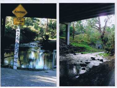
 Falls Creek Historical Society
Plan - Leases of part of Falls Creek Tourist Area
Bob (Herman) Hymans (a former member of the Royal Netherlands Navy was born in Bloemendaal, Holland on 30th September 1922. During World War II he fought against the Japanese in the Dutch East Indies (now Indonesia) and was imprisoned in Changi and on the Burma Railway. After gaining qualifications as a Ski Instructor, Bob arrived in Falls Creek in May 1950. Working as an Instructor and Supervisor at Bogong Lodge, Bob decided his future was in accommodation. He was successful in negotiating an indenture for land from the State Electricity Commission (SEC). It took Bob two years to build his Grande Coeur Chalet but, tragically, it was burned down in August 1961. Bob also built the first Chairlift in Australia. This was a single chairlift and the structure was built from wooden electricity poles. He was constantly full of new ideas and proposals for the village. Bob Hymans died on 7th May 2007. This Collection of documents and letters tells the story of Bob’s endeavours to develop Falls Creek into the ski village it is today. This map is significant because it documents boundaries of early leases in Falls Creek Tourist Area.This map is part of Bob Hymans documents. It is a large Surveyor's Plan of a section of the Falls Creek Tourist Area. It is endorsed by J Parker, Chief Surveyor of the State Electricity Commission of Victoria on 27-3-84. It shows streets, lot numbers and measurements. It was a compilation created from existing lease maps. Heading - PART OF FALLS CREEK TOURIST AREA PART OF CROWN ALLOTMENT 1 PARISH OF CARRUNO PART OF CROWN ALLOTMENT 1 PARISH OF DARBALANG COUNTY OF BOGONGmap of falls creek, falls creek leases, falls creek 1980s -
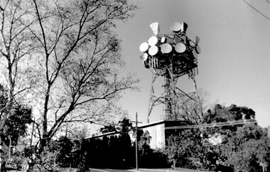 Surrey Hills Historical Society Collection
Photo, Telecom tower, Canterbury Road
This photo of the Telecom Tower was one of a series of photos taken of landmarks and houses of the area by Ken Hall in c1980. The PMG / Telecom / Telstra tower was built in 1961-1963 as a relay station to support television and radio links between city and regional broadcasting stations. The tower itself was 45 m in height with a 2 storey building for equipment and staff surrounded by garden. From the beginning it was opposed by local residents. In response to a Telstra application to replace it with a 40m slimline monopole, the City of Whitehorse controversially sought to have the structure heritage-listed, a move which caused much debate. In May 2015 Council ultimately rescinded its decision and gave permission for demolition, however Telstra deemed the permit conditions to be too restrictive and decided to continue to use the tower. The permit (to replace the tower) expired in September 2017. A black and white photo of local landmark visible from many vantage points in Surrey Hills and surrounding area, as it was built on the high point of the area.telecommunications tower, city of whitehorse, heritage overlay, heritage study, development, pmg tower, telstra, telecom, harding street, canterbury road -
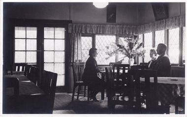 Marysville & District Historical Society
Photograph (Item) - Black and white photograph, Roy Liebig, 04-1949
A black and white photograph taken in a dining area in the Crossways Cabaret in April, 1949. The Crossways was built in the early 1920s and is the oldest building in Marysville. The Crossways historic inn survived the 2009 Black Saturday bushfires thanks to the efforts of its c-owner Greg Cherry and, in the days after the fires, provided a much-needed refuge to the Marysville community and firefighters. A black and white photograph taken in a dining area in the Crossways Cabaret in April, 1949.My wife Katie,/ does a little talking/ at the Crossways Cabaret./ Marysville Visit,/ April 1949.marysville, victoria, australia, photograph, the crossways cabaret, the crossways, crossways, crossways country inn, crossways historic inn, 2009 black saturday bushfires, accommodation, roy liebig -
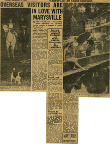 Marysville & District Historical Society
Newspaper (Item) - Newspaper article, The Argus Newspaper et al, Overseas visitors are in love with Marysville, 06-12-1955
A digital copy of a newspaper article regarding the need for the government of the time to make improvements on roads and to infrastructure at tourist sites in the Marysville area.A digital copy of a newspaper article regarding the need for the government of the time to make improvements on roads and to infrastructure at tourist sites in the Marysville area.Souvenir/ written by/ GORDON/ WILLIAMS/ and/ PERCY/ TAYLOR/ Photography/ by/ JACK/ LAWRENCEmarysville, victoria, newspaper article, the argus, jack lawrence, gordon williams, percy taylor, marysville tourist and progress association, lake mountain, steavenson falls, talbot drive, keppel falls, taggerty river -
Lakes Entrance Historical Society
Book, Voters Roll for the Bumbererrah Riding of the Shire of Tambo 1990-1991, 1990
Alphabetical list of Voters in the Nungurner, Kalimna West, Metung areas, Bumberrah Riding, Shire of Tambo, Victoria, giving names and addressesAlphabetical list of Voters in the Nungurner, Kalimna West, Metung areas, Bumberrah Riding, Shire of Tambo, Victoria, giving names and addresseselectoral rolls, directories -
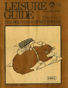 Marysville & District Historical Society
Magazine (Item) - Leisure guide, Michael Cheshire, LEISURE GUIDE THE MOUNTAINS OF MELBOURNE, 1984
A leisure guide to the mountains of Melbourne beginning in the eastern suburbs, going through the Yarra Valley and into the Great Dividing Range. This was produced by Michael Cheshire as a free publication to promote Melbourne tourism. The magazine featured Healesville, Marysville, Warburton, Eildon, Alexandra, the Upper Yarra area, and includes information on wineries in the district. It was released in the summer of 1984-1985.A leisure guide to the mountains of Melbourne beginning in the eastern suburbs, going through the Yarra Valley and into the Great Dividing Range.Summer Edition 1984-85 Featuring:/ Healesville, Marysville, Warburton, Eildon,/ Alexandra, Wineries and Upper Yarra Area.healesville, warburton, eildon, alexandra, upper yarra, marysville, victoria, australia, leisure guide, michael cheshire, blackwood holiday flats, black spur motel and caravan park, tudor lodge road house, nanda binya lodge, marysville caravan park, marysville recreation and fun park, scenic motel, the tower motel, the cumberland, cathedral restaurant, cathedral restaurant gallery, taggerty golf course, taggerty holiday units, marylyn guest house -
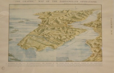 Lara RSL Sub Branch
Topagraphical Map of the Dardanelles Operations, Graphic Map of The Dardanelles Operations
WW1, Dardanelles operational map of area of Operations. Military, Naval of the "battering of the Gates of Constantinople"WW! ANZAC, British Military and Naval Operations in the Dardanelles. "battering of the Gates of Constantinople"Graphical representation of the Dardanelle's Operations displaying the Australia & New Zealand and the British operational areas and Landings. Military and Naval involvements in battering the gates to Constantinople.Small circular stamp on front left bottom - "State Library of N.S.W." and on he right hand border " Z M2 390 8/1915/3"ww!, military, naval, battering of the gates of constantinople, australia and new zealand (anzac) -
 Sunbury Family History and Heritage Society Inc.
Photograph, Sunbury & District Heritage Association Inc, Vineyards Exhibition, August 1996
The vineyards exhibition was mounted by the Sunbury & District Heritage Association in the former George Evans Museum from August 1996 to January 1997. It featured the establishment of the vineyards and the wine industry in Sunbury from the 1860s to the present day. From the early days of European settlement in Sunbury, it was found that the soils and climate suited the growing of grapes, especially the east facing slopes along Vineyard Road. A number of people of German origin established vineyards along there. By the end of the nineteenth century and limited spending power as a result of the 1890s depression, the demand for wine declined in Victoria with beer being the preferred beverage.While Phylloxera destroyed the vines in many areas of Victoria, Sunbury's grapevines were not affected. As the demand for wine increased in the 1960s - 70s, some vineyards in the Sunbury area were replanted.The vineyards established in Sunbury in the 1860s were one of the earliest agricultural pursuits taken up by European settlers in the area and remained an important industry for 40 years.A non-digital coloured photograph of a display board advertising an exhibition of vineyards in the Sunbury area.vineyards, sunbury, vignerons, wine production -
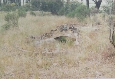 Tatura Irrigation & Wartime Camps Museum
Photograph, Arthur Knee, Camp 13 stone bridge, 1989
Camp 13, administration area, s.w. corner near Commandants house. Made by prisoners using local stone.Camp 13, Camp Road, Murchison, Victoria. Stone work,ornamental pond, bridge, s.w. corner near administration area - remnants.Camp 13 West Garrison Gardens - Stone bridge over figure 8 poolcamp 13, murchison victoria, pow, internment camps, stonework