Showing 475 items
matching australia - army - royal australian regiment
-
 Bendigo Military Museum
Print - PRINT, FRAMED
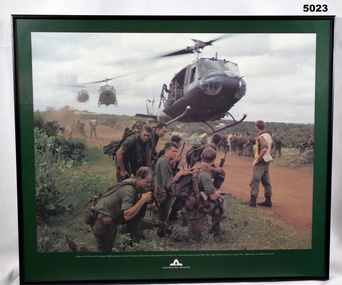
Caption under print. Soldiers of 5 Platoon, B Company, 7 RAR, preparing to board VS Iroquois helicopters during operation Ulmarrah, the cordon and search of Lang Phuoc Hai Village, South Vietnam, 26 August 1967". Members of 5 Platoon, B Company, 7th Battalion, The Royal Australian Regiment (7RAR), just north of the village of Lang Phuoc Hai, beside Route 44 leading to Dat Do. United States Army Iroquois helicopters are landing to take them back to Nui Dat after completion of Operation Ulmarra, the cordon-and-search by 7RAR of the coastal village of Lang Phuoc Hai. Operation Ulmarra was conducted by 2nd Battalion, The Royal Australian Regiment (2RAR) and 7RAR with support elements. Left to right: Private (Pte) Peter Capp (kneeling); Pte Bob Fennell (leaning over, facing camera, with an ammunition belt for an M60 machine gun slung over his shoulder); Corporal Bob D'Arcy (partly obscured behind Fennell); Pte Neal Hasted (centre, front); Pte Ian Jury (partly obscured, centre, rear, holding rifle); Pte Colin Barnett (front, right, M60 ammunition belt on back, back of head to camera); Lance Corporal Stan Whitford (partly obscured behind Barnett); the helicopter marshal at right is Pte John Raymond Gould, 7RAR. The United States Army Iroquois UH-1D helicopter was operated by 2 Platoon, 162nd Assault Helicopter Company, 11th Combat Aviation Battalion. (Having achieved almost the status of an icon, this image was chosen for, and is etched on, the Australian Vietnam Forces National Memorial on Anzac Parade, Canberra, ACT, dedicated in October 1992). Source AWM Print donated and dedicated to 3789179 FRANK FRIGERIO, 5 Platoon, B Company, 7RAR. See also Cat No. 3543-3549.3Print - coloured print of a photograph depicting three helicopters coming in to land above a dirt road with several groups of soldiers in uniform with jungle vegetation in the background. Frame - black painted metal.See in context, historical - caption under print.prints, framed, accessories, vietnam war -
 Bendigo Military Museum
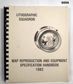
Manual - Map Reproduction and Equipment Specification Handbook, 1982
This handbook provided comprehensive technical information principally to the lithographic technician and to other Royal Australian Survey Corps technical trades. Part 1 comprised technical descriptions and photos of lithographic equipment used in military map production. Part 2 provided various tables such as printing sizes conversion tables. Part 3 provided technical guidance on the stipples and screens utilised in the map reproduction process. Part 4 detailed the Pantone Matching System printing colours for map and chart products. Part 5 was a Glossary of Lithographic Technical Terms.Army Survey Regiment Manual/handbook with a manilla cover comprising approximately 100 pages. The pages in the document are in black and white paper providing technical information and photograph identifying lithographic equipment and other information to lithographic technicians. Printed on standard paper bound by a by a black plastic spiral spline.royal australian survey corps, rasvy, fortuna, army svy regt, asr, army survey regiment -
 Bendigo Military Museum
Manual - DRAFT SPECIFICATIONS FOR TOPOGRAPHIC MAP SERIES, Specifications for 1:50000 and 1:25000 maps produced in Australia, Circa 1973
These draft Specifications set out the Standards for the production of topographic maps within the Commonwealth of Australia at scales of 1:50000 and 1:25000 and are designed to satisfy the basic requirements of both civil and military map users.Hard cover, cloth, Red, 11 Annexes, Supplementary documents.royal australian survey corps, rasvy, fortuna, army survey regiment, asr -
 Bendigo Military Museum
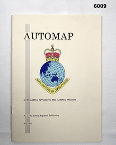
Pamphlet - AUTOMAP - Automation Applied to the Mapping Process, Major Sam Thompson US Army Corps of Engineers, 01.07.1977
... Regiment, Bendigo Royal Australian Survey Corps RASvy Fortuna Army ...This pamphlet produced by Major Sam Thompson US Army Engineer Corps on exchange to Australia was published as a guide to AUTOMAP 1, the Army Survey Regiment’s first computer-based map production system. It examined how automation had changed the compilation and drafting phases of the map production process. It attempted to present in a light-hearty story telling style, short and clear description of each AUTOMAP 1 sub-system with photos of staff and equipment, diagrams and humorous cartoons. The cartoonist is unknown. The pamphlet was printed at the Army Survey Regiment, Bendigo Army Survey Regiment pamphlet comprises a manilla card cover printed in colour with 24 pages with photographs in black and white; and descriptions, diagrams, and cartoons printed in colour. It is bounded by two staples on its spine. The coloured pages have been scanned at 300 dpi and are stored on a USB Digital Storage Device. The page images have been converted into a video (.mp4) format and also stored on the USB. The video is 1.3Mb in size and runs for 1.3 minutes.royal australian survey corps, rasvy, fortuna, army survey regiment, army svy regt, asr -
 Bendigo Military Museum
Pamphlet - An Introduction to Topographic Mapping, C 1991
This pamphlet was published by the Army Survey Regiment as an overview of the Royal Australian Survey Corps (RASvy), its role and unit structure circa 1991, prior to RASvy’s disbandment in 1996. The pamphlet comprehensively detailed the eight steps of topographic map production: Establish Survey Control, Aerial Photography, Aerotriangulation, Stereoplotting, Field Verification, Cartography, Printing and Storage/Map Distribution. Leading technologies used by RA Svy in 1991 included GPS control surveys, 5 colour printing on the Speedmaster offset press and bulk map packaging using the Map Handling Station (with guillotine). Digital map production was operating on the AUTOMAP 2 system, before the “Newheart” system upgrade two years later. Printed on the pamphlet cover was a portion of the plane tabled “four inches to a mile” map of Newcastle. This was compiled and surveyed in 1910 by LCPL A. Barrett, a member of the RAE Detachment, as part of the first major topographic mapping effort of Australia.This is a Royal Australian Survey Corp pamphlet with a historical map printed in colour on cardboard on both sides of the cover. There are 16 pages printed in colour on gloss paper, with photos, diagrams and descriptions. The pamphlet is bounded by two staples on its spine. Each of the 17 images were scanned at 300 dpi in JPEG (.jpg) format and stored on the attached 16 Gb USB memory stick. The images have been converted into MPEG-4 (.mp4) video format, 4Mb in size and runs for 2:16 minutes and is also stored on the memory stick.royal australian survey corps, rasvy, fortuna, army survey regiment, army svy regt, asr -
 Lara RSL Sub Branch
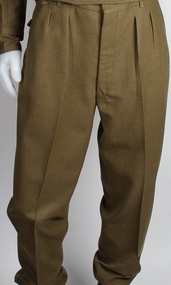
Army Trousers, E.W. PTY LTD, Australian Army Trousers, c. 1968
... by the Royal Australian Army (Royal Australian Artillery Regiment ...These trousers, along with the rest of the dress uniform, belonged to an individual named H.E. Schulze. It is believed to have been dropped off to the RSL, so no additional information is known.This uniform serves as an example of the military dress worn by the Royal Australian Army (Royal Australian Artillery Regiment) during the late sixties.Khaki trousers with pleats and a series of belt loops at the waist; two front pockets; and three buttons positioned at the left, right, and centre of the back of the trousers (for attaching a jacket to the trousers). There is a large tear in the seat.lara, rsl, royal australian army, royal australian artillery, war -
 Lara RSL Sub Branch
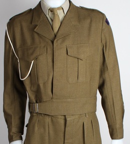
Army Jacket, E.W. PTY LTD, Australian Army Jacket, 1968
... of the military dress worn by the Royal Australian Army (Royal Australian ...This jacket, along with the rest of the dress uniform, belonged to an individual named H.E Schulze. It is believed to have been dropped off to the RSL, so no additional information is known. This uniform serves as an example of the military dress worn by the Royal Australian Army (Royal Australian Artillery Regiment) during the late sixties.Khaki jacket featuring two buttoned chest pockets and a belt. A rope cord is draped across and under the right shoulder of the jacket (referred to as a lanyard). There is a single patch (of red and blue colouring) that is located at the top of both sleeves, with an additional patch at the bottom of the left sleeve.Both patches read "ROYAL AUSTRALIAN ARTILLERY". Inside jacket tag reads "E.W. PTY/LTD. / SOUTH AUSTRALIA 1968 / CLASS 8405-66-025-6422 / BATCH 8/68 / MILL AV / SIZE OF CHEST 41/42 PR / MATCHING TROUSERS 39 PR / DRY CLEAN ONLY / CREASE UPPER HALF / OF LAPELS ONLY / NAME: SCHULZE HE / ARMY No. 3164207"lara, rsl, royal australian army, royal australian artillery, war -
 Lara RSL Sub Branch
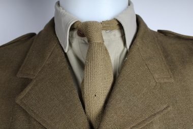
Army Shirt, Australian Army Shirt, c. 1968
... of the military dress worn by the Royal Australian Army (Royal Australian ...This shirt, along with the rest of the dress uniform, belonged to an individual named H.E. Schulze. It is believed to have been dropped off to the RSL, so no additional information is known. This uniform serves as an example of the military dress worn by the Royal Australian Army (Royal Australian Artillery Regiment) during the late sixties.Khaki coloured, button-down collared shirt. Staining can be seen across the front of the shirt, as well as the sleeves.lara, rsl, royal australian army, royal australian artillery, war -
 Lara RSL Sub Branch
Army Tie, Australian Army Tie
... of the military dress worn by the Royal Australian Army (Royal Australian ...This tie, along with the rest of the dress uniform, belonged to an individual named H.E Schulze. It is believed to have been dropped off to the RSL, so no additional information is known.This uniform serves as an example of the military dress worn by the Royal Australian Army (Royal Australian Artillery Regiment) during the late sixties.Khaki tie that is missing the bottom section (appears to have been cut off).lara, rsl, royal australian army, royal australian artillery, war -
 Lara RSL Sub Branch
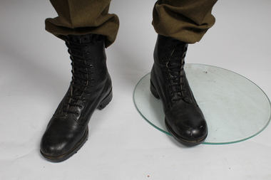
Army Boots, Australian Army Boots
... of the military dress worn by the Royal Australian Army (Royal Australian ...These boots, along with the rest of the dress uniform, belonged to an individual named H.E. Schulze. It is believed to have been dropped off to the RSL, so no additional information is known.This uniform serves as an example of the military dress worn by the Royal Australian Army (Royal Australian Artillery Regiment) during the late sixties.Pair of polished, lace-up, black leather boots.lara, rsl, royal australian army, royal australian artillery, war -
 Lara RSL Sub Branch
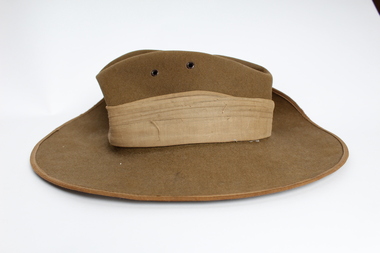
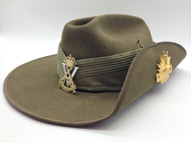
Army Hat, Australian Army Slouch Hat
... of the military dress worn by the Royal Australian Army (Royal Australian ...This hat, along with the rest of the dress uniform, belonged to an individual named H.E Schulze. It is believed to have been dropped off to the RSL, so no additional information is known.This uniform serves as an example of the military dress worn by the Royal Australian Army (Royal Australian Artillery Regiment) during the late sixties.A khaki coloured Australian military felt hat. The left side has been folded up and pinned with an Australian Infantry Combat Badge. A safety pin is attached to the underside of the hat.lara, rsl, royal australian army, royal australian artillery, war -
 Lara RSL Sub Branch
Service Gear, Clothing Military Various - Puggaree
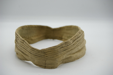
The term ‘puggaree’ originates from the Hindu word, ‘Pagri,’ meaning a turban or thin scarf of muslin. Intended for insulation, the puggaree was a traditional Indian head-wrap, adapted by the British for headdress worn in hot, sunny regions. During World War One (1914-1918) a plain khaki cloth band was worn and this practice continued until compulsory training was suspended in 1929. Following the introduction of Voluntary Training in 1930, new puggarees were issued to the Commonwealth Military Force with different coloured folds denoting Arm or Service. During World War Two, a flat type of band was issued. Troops who were on active service in the Middle East at the time introduced a folded puggaree as a distinguishing mark of active service. Later, the Army reverted to various types of plain bands, green dyed puggarees for example, for jungle warfare. However, the official puggaree at the conclusion of World War Two was still the flat band. The current puggaree has seven pleats, one for each state and one for the Australian Territories. It is made from light khaki coloured cotton and is worn on the slouch hat with a unit colour patch sewn on the right side. While the majority of the Australian Army wear the light khaki coloured puggaree, there are slight variations for members of the 1st Battalion, the Royal Australian Regiment, and the Corps of Staff Cadets. Soldiers of the 1st Battalion, the Royal Australian Regiment, wear jungle green puggaree. The dark green puggaree was introduced during the Battalion’s service in Malaya over the period 1959-61. Unable to get puggarees from Australia for an official parade; the task of producing them was given to the Battalion tailor, Mr. Mohavved Beseek. Mr Beseek used ‘bush shirts’ (common issue British field uniform at the time) to make the puggarees as he was unable to obtain the khaki material locally or from Australia. It is thought that the Commanding Officer, Lieutenant Colonel W. Morrow decided that the green puggaree would be the puggaree worn by the 1st Battalion, the Royal Australian Regiment, in Malaya. After the battalion’s return to Australia, the dark green puggaree was adopted for permanent use. Because the dark green puggaree is so distinctive, the battalion does not wear a colour patch. Royal Military College staff cadets wear a distinctive puggaree of olive drab colour. The puggaree has eight pleats, with seven representing each state and one for the Australian Territories. The eighth pleat signifies the graduation of the first international cadet through the Royal Military College who hailed from New Zealand. Worn on slouch HatHat BandNilpuggaree,hat band, slouch hat, lara rsl -
 Lara RSL Sub Branch
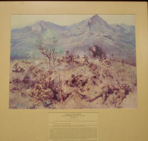
Special General Order.Battle Honours-Citation Of Units,28th June 1951, Circa 1970
During 1951, the 3rd Battalion, The Royal Australian Regiment (3 RAR), fighting as part of a British Commonwealth Brigade in Korea, was engaged in the two most significant and commemorated battles of the Australian Army’s deployment to the three-year Korean War.The battles of Kapyong (23–24 April 1951) and Maryang San (2–8 October 1951) were significant confrontations with a numerically superior enemy force, and saw 3 RAR win the first honours for the newly formed Royal Australian Regiment.Framed Glass covered Print,Rectangular in Shape showing a painting of Australian soldiers fighting the enemy near Kapyong,Korea,in 1951,with a description underneath. Detailed description of the Special General Order,Battle Honours-Citation of Units. 28th June 1951 General Mathew B Ridgeway, Supreme Commander UNITED NATIONS FORCES prints, framed paintings, korea, lara r.s.l., korean war, battle honours, special general orders, citation of units -
 Lara RSL Sub Branch
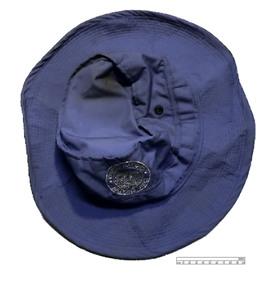
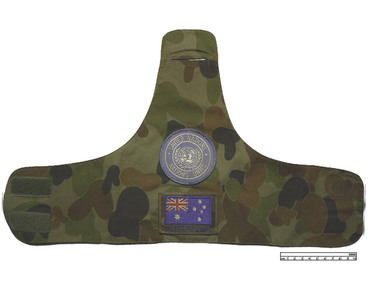
Hat, United Nations Timor Hat Blue, 2001 (estimated)
... military army blue royal australian army east timor australian army ...Used by Australian United Nation forces in East TimorBlue United Nations floppy hat with United Nations Badge on front of hat. Hat is circular and can be squashed up to fit in baggage. Made in China of cotton material.Has United Nations Badge on front of hatunited nations, timor, hat, military, army, blue, royal australian army, east timor, australian army, royal australian regiment, rar, un, cotton, made in china -
 Lara RSL Sub Branch
Armband, United Nations Armband Timor, 2001 (estimated)
... australian army timor east timor australian army royal australian ...Camouflaged coloured East Timor United Nations armband with United Nations badge with the words at top of badge, United Nations and words below Nations Unies. Below the UN Badge is an Australian flag Badge with Australia written underneath the flag.United Nations badge in middle and underneath Australian flag with the word Australia underneathmilitary, army, royal australian army, timor, east timor, australian army, royal australian regiment, rar, united nations, un, cotton, made in china, armband, camouflage -
 Lara RSL Sub Branch
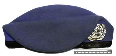
Cap, United Nations Timor (blue) Cap, 2001 (estimated)
... australian army timor east timor australian army royal australian ...Used by Australian United Nation forces in East Timor.United Nations Blue Timor Cap with black trim at bottom and metal United Nations badge at front right hand sideUnited Nations Badge in metalmilitary, army, royal australian army, timor, east timor, australian army, royal australian regiment, rar, united nations, un, cotton, made in china, cap -
 Lara RSL Sub Branch
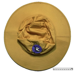
Hat, Yellow United Nations Peace Monitoring Group Bougainville, 1996 (estimated)
... military army royal australian army australian army royal ...Used by Peace Keeping Forces in Bougainville, Papua New Guinea in the 90'sYellow United Nations floppy hat with United Nations Peace Monitoring Group Badge on front of hat. The Peace Monitoring Group badge has PEACE in black above the badge and Peace Monitoring Group in black beneath. The badge has a white dove on a blue background with black olive branch. Underneath dove is map of Papua New Guinea. Hat is circular and can be squashed up to fit in baggage. Made in China of cotton material.Has Peace Monitoring Group badge on front. Badge has black writing with white dove on blue sky with green olive branchhat, military, army, royal australian army, australian army, royal australian regiment, rar, united nations, un, cotton, made in china, bougainville, papua new guinea, yellow -
 Lara RSL Sub Branch
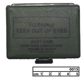
Face Paint, Camouflage Face Paint Box
... australian army timor east timor australian army royal australian ...Green camouflage face paint plastic box with flip lid.WARNING KEEP OUT OF EYES - AUST CAM - PAINT FACE CAMOUFLAGE - NSN O850-6C-130-0172 WITH SUNSCREENmilitary, army, royal australian army, timor, east timor, australian army, royal australian regiment, rar, united nations, un, camouflage, plastic, face paint -
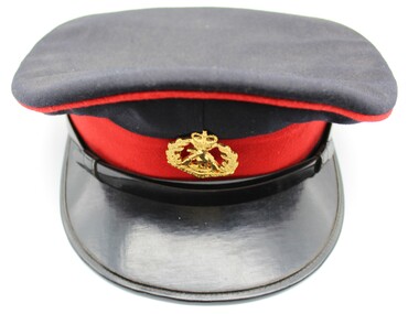 Shepparton RSL Sub Branch
Uniform, Hat, Emerco
... the-murray royal australian regiment rar army uniform Sticker reads ...Navy-black coloured peaked cap with red piping trim along peak. Red felt band encircles the band. Black patent leather chin strap is held in place with two gold buttons on either side, each depicting a crown above the map of Australia. Gold badge in centre depicts kangaroo in front of crossed rifles underneath a crown with oak leaves forming an arch eitehr side. Interior brim is green with black patent leather trim; brown leather sweatband with holes for air cirulation, tied at back with cream silk bow. Top of hat is covered with plastic layer, underneath which is the manufacturer’s label and a sticker for size.Sticker reads “6 7/8”, and manufacturer’s label reads “MELBOURNE 36 1218/EMERCO/REG TRADE MARK/THIS IS YOUR GUARANTEE FOR QUALITY/MADE IN AUSTRALIA”. Badge reads “DUTY FIRST/ROYAL AUSTRALIAN REGIMENT”.royal australian regiment, rar, army, uniform -
 Bendigo Military Museum
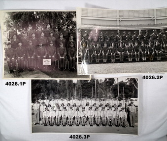
Photograph - PHOTOGRAPHS, MILITARY, (.1) June 1961
The photos all relate to the collection of Francis William (Dinky) DEAN BEM, VX93960 2nd AIF, 3472 1 RAR, 1943 - 1975. Refer Cat No 124.2 for his service details. (.1) The sign “6/58 ARA RQMS Course June 1958” ARA (Australian Regular Army) RQMS (Regimental Quarter Master Sergeant) Frank Dean is in 2nd row 1st on the right. (.2) Possibly the Officers and Senior NCO’s of 1 RAR in the late 1950’s. (.3) Some time in the 1960’s as many are wearing Vietnam ribbons. Frank Dean is 1st on the right 2nd row. (.4 - .6) “D Coy 1st Battalian of the Royal Australian Regiment”. Possibly taken in the late 1950’s. Frank Dean is in the 2nd row from bottom, 12th from the right. All photos are B & W. (.1) Large group of 25 soldiers in 3 rows with sign in front. (.2) Large group of 41 soldiers in 3 rows with building behind. (.3) Large group of 46 soldiers in 3 rows, gardens and car in background. (.4 - .6) Large group of soldiers in 3 rows with sign and flag in front.photography, military -
 Bendigo Military Museum
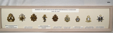
Badge - BADGES, FRAMED, c.1998
... BARRACKS 1964 TO 1977” Underneath each badge: “1. Royal Australian... Battalion Royal Victorian Regiment 2. & 3. Royal Australian Army ...Cream wooden framed selection of 9 badges displayed on cream coloured background.Top centre: “BADGES OF CORPS ASSOCIATED WITH PASSCHANDAELE BARRACKS 1964 TO 1977” Underneath each badge: “1. Royal Australian Infantry 2nd Battalion Royal Victorian Regiment 2. & 3. Royal Australian Army Service Corps 4. Royal Australian Electrical & Mechanical Engineers” 5. Royal Australian Army Medical Corp 6. Australian Army Catering Corp 7. Women's Royal Australian Army Corps 8. Royal Australian Army Ordnance Corps 9. Royal Australian Corps of Transportpasschendaele barracks trust, badges, framed -
 Bendigo Military Museum
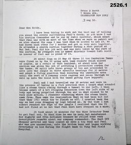
Letter - LETTER, VIETNAM, 3.8.1992
Letter written to Mrs Reidy by her son Paul's Section Commander BRUCE D SCOTT. It details the circumstances of PAUL REIDY'S death in Vietnam on 25.5.1969. It was during “Operation Reynella” around the Long Hai Mountains. Paul Francis Reidy No 3793403. A National Serviceman Paul served Vietnam first in 1 ARU from 24.2.1969 - 17.3.1969 and then posted to B Coy 9 RAR 18.3.1969 until his death. Bruce Donaldson Scott No 213485. Australian Regular Army served Vietnam first in 1 ARU from 10.3.1969 - 1.4.1969 and then posted to B Coy 9 RAR 2.4.1969 until being Medivaced home on 2.6.1969. 1 ARU (1st Australian Reinforcement Unit) 9 RAR (9th Battalion of the Royal Australian Regiment) Refer 1189.5, 2224, 2237.2P re Paul Reidy. Copy of typed two page letter on A4 paper from BRUCE D SCOTT to Mrs Reidy.documents - letters, military history -
 Bendigo Military Museum
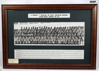
Photograph - PHOTOGRAPH - FRAMED, Framed photograph of 'A Company 1st Battalion The Royal Australian Regiment/Selarang Garrison - Singapore - Oct 1970', 1970
The photo relates to Francis William (Dinky) Dean BEM, VX93960 2nd AIF, 3742 1 RAR. Refer Cat No 124.2 for his service details. Framed photograph of 'A Company 1st Battalion The Royal Australian Regiment/Selarang Garrison - Singapore - Oct 1970' Staff Photograph. Photograph: Group black and white photograph of soldiers in uniform. Printed information (row position and names) provided below photograph. Frame: timber with decorative edge, mid brown colour stain, glass front. Mount: dark green coloured cardboard.Printed label above photograph: "A Company 1st Battalion The Royal Australian Regiment/Selarang Garrison - Singapore - Oct 1970" Bottom left on glass, printed label in black ink. "FRANK (DINKY) DEAN BEM/ Front row 7 from right/ donated by/ Mrs M Dean/ Refer book 54" photography, military, accessories, history, army -
 Frankston RSL Sub Branch
Badge
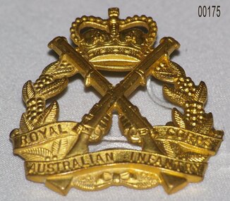
The Royal Australian Infantry Corps (RA Inf) is the parent corps for all infantry regiments of the Australian Army. It was established on 14 December 1948, with its Royal Corps status being conferred by His Majesty King George VI. At her coronation in 1953, Queen Elizabeth II became Colonel-in-Chief of the corps. Major components of the RA Inf include the various battalions of the Royal Australian Regiment and the six state-based Reserve infantry regiments, such as the Royal New South Wales Regiment. The various Regional Force Surveillance and Special Forces units of the Army are also part of the corps. The Infantry School is located at Singleton, New South Wales.Pressed metal cap badge for the Royal Australian Infantry Corp. This badge is brass alloy with two pins at rear for securing to the cap when worn."Royal Australian Infantry Corps" -
 4th/19th Prince of Wales's Light Horse Regiment Unit History Room
Specifications, Army Insignia, Badges and Buttons, 1951 - 1980
Set of manufacturing specifications for Australian Army insignia, badges and buttons - on foolscap in two lever arch files Specifications include: VOLUME 1 Badges, head dress & collar, AMF Insignia, shoulder, title, AUSTRALIA Insignia, metal, AUSTRALIAN ARMY Button, insignia, AMF Badge, metal, qualification, skill-at-arms Medallion & lapel badge, ANZAC commemorative Badge, lapel, metal, Army Reserve Lapel badge, Returned from Active Service Insignia, metal, Royal Cipher, Queen Elizabeth II Badge, metal, retired officers Button, insignia, general officer Link, button Insignia, metal, rank, womens, Warrant Officer & NCO tropical Insignia, metal, rank, officer, sword & baton crossed (1975) Insignia, metal, rank, officer, sword & baton crossed (1969) Insignia, metal, rank, officers, crown Insignia, metal, rank, NCO, crown Insignia, metal, rank, Warrant Officer, crown Palm leaf device for Vietnamese Cross of Gallantry Medal, service, Vietnamese campaign Button, insignia, Corps of Staff Cadets Insignia, metal, RAAC, beret/collar Insignia, metal, 1 AR, beret/collar Insignia, metal, 1/15 RNSWL, beret/collar Insignia, metal, 2 Cav, beret/collar Insignia, metal, 2/14 QMI Insignia, metal, 3 Cav, beret/collar Insignia, metal, 3/9 SAMR Insignia, metal, 4 Cav, beret/collar 4/19 PWLH Regt badge, head dress or collar Insignia, metal, 4/19 PWLH 8/13 VMR badges, head dress or collar Insignia, 10 LH, collar, silver plated 12/16 HRL, badges, head dress or collar Insignia, metal, RAA, officers, cap/hat, collar Insignia, metal, RAA, other ranks Button, insignia, RAA Button, insignia, RAE Insignia, metal, RAE cap/hat collar Button, Insignia, Royal Aust Survey Corps Insignia, metal, Royal Aust Survey Corps Insignia, metal, Royal Aust Corps of Signals, cap/collar Button, insignia, Royal Aust Corps of Signals Button, insignia, R Aust Inf Insignia, metal, R Aust Inf, cap/hat, collar Insignia, metal, Commando Insignia, metal, RSAR, cap/hat collar Insignia, metal, RAR, cap/hat collar Insignia, metal, RNSWR Insignia, metal, RVR, cap/hat Insignia, metal, RQR ,cap/hat collar Insignia, metal, RWAR, cap/hat collar Badge, qualification, Infantry Combat Button, insignia, Chaplains, Christian Insignia, metal, Chaplains, Christian, cap/hat collar Insignia, metal, RACT Button, insignia RACT Button, insignia, RAAMC Insignia, metal, RAAMC, cap/hat collarl, Insignia, metal, RAADC, cap/hat collar Button, insignia, RAAOC Insignia, metal, RAAOC' VOLUME 2 Button, insignia, RAEME RAEME, badges, collar Insignia, metal, R Aust Army Educational Corps, cap/hat collar Button, insignia, AACC Insignia, metal, AACC, cap/hat collar Button insignia, R Aust Army Pay Corps Insignia, metal, R Aust Army Pay Corps, cap/hat collar Insignia, metal, Aust Army Legal Corps, cap/hat collar Insignia, metal, R Aust Army Provost Corps, cap/hat collar Button, insignia, R Aust Corps of MP Button, insignia, Aust Army Psych Corps Insignia, metal, Aust Army Psych Corps Button, insignia, Aust Army Nursing Corps Insignia, metal, R Aust Army Nursing Corps Button, insignia, WRAAC Insignia, metal, rank, mess undress, brooch type, RAAMC Insignia, metal, WRAAC Insignia, shoulder, Apprentice Insignia, metal, Army Apprentices School Button, insignia, OCS Button, insignia, OCS ,blazer Insignia, metal, OCS, cap/hat collar Button, insignia, RMC, blazer Insignia, metal, RMC Medallion, RMC Insignia, metal, AUR, cap/hat collar Button, insignia, MonUR Insignia, metal, MUR, cap/hat collar Button, insignia, MonUR Insignia, metal, MonUR, cap/hat collar Insignia, metal, UNSWR , cap/hat collar Insignia, metal, SUR, cap/hat collar Button, insignia, SUR Insignia, metal, QUR, cap/hat collar Button, insignia, QUR Insignia, metal, WAUR, cap/hat collar Button, insignia, WAUR Badge, metal, qualification, flying, Army pilot, Aust Army Aviation Corps Insignia, metal, Aust Army Aviation Corps Button, insignia, Aust Army Aviation Corps Badge, metal, qualification , bandsman Badge, metal, qualification, Drum Major Button, insignia, Aust Army Band Corps Insignia, metal, Aust Army Band Corps, cap/hat collar Rubber stamp of Engineering Design Establishment giving conditions of issue to contractorsspecifications -
4th/19th Prince of Wales's Light Horse Regiment Unit History Room
Flag, 173rd Airborne Brigade (US)
173 AIRBORNE BRIGADE (SEPARATE) US ARMY 1 RAR BATTLE GROUP BIEN HOA 1965-1966 On May 5, 1965, the Brigade deployed to South Viet Nam as the first US Army ground combat unit in that war. Upon arrival, the 1st Battalion of the Royal Australian Regiment (1 RAR) and a battery from New Zealand (161Royal NZ Artillery) were attached to the Brigade -- making the 173d Airborne the only multi-national combat unit in the war. Initially headquartered in Bien Hoa, the Brigade operated in the four provinces around Saigon. (Xuan Loc, Long Khanh, Phuoc Long & Phuoc Tuy), but (in its roll as a "Fire Brigade") also went to the Central Highlands (Pleiku / Kontum) to fight Viet Cong. The 173d also conducted constant operations against the southern stronghold of the VC Main Force in the legendary Iron Triangle in War Zone D. The brigade was organized as a balanced airborne combat force consisting of two infantry battalions, an artillery battalion, a support battalion, an engineer company, a cavalry troop, an armour company, and a headquarters company. Upon activation, it became the first and only separate airborne brigade in the United States Army. This was the beginning of a long series of "Firsts" for the Brigade. On 5 May 1965, it became the first US Army ground combat unit committed to the war in South Vietnam, where further organizational changes were to take place. Australians attached to the Brigade were: 1st Battalion, of the Royal Australian Regiment (I RAR) and support troops of the 4/19th Prince of Wales Light Horse Regiment (1Troop), 105 Field Battery Royal Australian Artillery, 161 Field Battery Royal New Zealand Artillery, 3 Field Troop Royal Australian Engineers, 161 Reconnaissance Flight, Royal Australian Army Air Corps, 1st Australian Logistical Support Company. The Brigade's two infantry battalions, the First Battalion of the 503' Infantry (1/503`d) and the Second Battalion, of the 503`d Infantry (2/503`) and the attached Australians of 1 RAR constituted the infantrymen available to the Brigade. Their mission was to protect the Bien Hoa Air Base and to close with and destroy or capture the enemy. This was in fact the first operational ground force formed under the ANZUS Defence Treaty. ANZUS was a mutual defence treaty signed in 1951 between Australia, New Zealand and the United States of America. In 1965 the spirit of this treaty appeared as 173d Airborne Brigade (Sep) a tri-national brigade. The only such tri-national fighting force formed during the Vietnam War. On deployment to South Vietnam in 1965, 1 Troop A Squadron, 4th/19th Prince of Wales's Light Horse Regiment was part of the US 173rd Airborne Brigade combat group. Flag, two colours divided vertically, hoist half mid blue, fly half red. Badge of 173rd Airborne Brigade (730 x 490 mm) in centreflag, 173rd airborne, south vietnam -
4th/19th Prince of Wales's Light Horse Regiment Unit History Room
Record of Interview, Jeff TunTin, 3 Dec 2003
Jeff Tun Tin served in the Australian Regular Army, in the Royal Australian Armoured Corps. Among other postings, he served in 3 Cav Regt and did two tours of South VietnamJeff Tun Tin was RSM of 4th/19th Prince of Wales's Light Horse Regiment from 1987 - 1989A4 transcript of Australian War Memorial interview with WO1 Jeff Tun TinAWM Archive Number 1244 -
 Montmorency/Eltham RSL Sub Branch
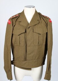
Uniform - Blouse, Khaki, Patt.'49 Battle Dress, 1949 Battle Dress, 1988
Pattern 1949 Khaki woollen battle dress blouse. Five front buttons. Two front pockets, one on the left and one on the right.Two buttoned epaulets with embroidered crowns signifying rank of Captain.Royal Australian Regiment patches sewn on the left and right shoulders. Belted at the waist..Two red patches on each shoulder embroidered with Royal Australian Regiment. Identification tag sewn on the inside at the back of the neck - Docket number - 39614-14. Size - J K + M Serge KH. Garment no. - 209. Remarks - Vanzwol or Vanswol, J handwritten on tag. Tag sewn inside left front panel - A.G.C.F. VIC 1988 ARMY NO. NAME B34 handwritten. Care states - dry clean only, crease upper half of lapels only.battle jacket, royal australian regiment, van swol, van zwol, vanswol, vanzwol -
 Montmorency/Eltham RSL Sub Branch
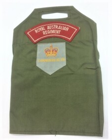
Uniform - Brassard, Sleeve, Circa 1950
... Royal Australian Army Regiment Commonwealth Name K R... Number A003610 korean war brassard royal australian army regiment ...Identification brassard from 1st Commonwealth Division, KoreaDonated by: K R Faulks Rank Pte, Number 1/1096, date of birth 24 Feb 1930, Identify Card Number A003610Brassard - upper sleeve attachment for shirt, showing unit designationRoyal Australian Army Regiment Commonwealth Name K R Faulks Rank Pte, Number 1/1096 and signed K R Faulks on back of card Nationality Australian, date of birth 24 Feb 1930, Identify Card Number A003610, date of issue 15th June 54 and signed by Issuing Officer Capt Adjt, 1 Rft Holding Unitkorean war, brassard, royal australian army regiment, 1st commonwealth division, korea, australian army -
 Montmorency/Eltham RSL Sub Branch
Headwear - Slouch hat, 1990
Standard issue hat to Army Reserve unit. Representative uniform itemKhaki Australian Army slouch hat (fur felt) with khaki cloth puggaree. Cloth black over red rectangular colour patch on right hand side of puggaree. Gilt metal Royal Victoria Regiment cap badge on front of puggaree. Australian Army rising sun badge on left side turned up brim. Brown vinyl sweat band. Chin strap missing. Hat mounted on plywood carrying board. Bardsley Hats 1990 broad arrow Fur felt 54 gold stencil on sweat band. "319232 READ R" handwritten inside sweatband "Sgt Nicholls" handwritten brown marker pen on mounting board slouch hat, australian army, australian army slouch hat, bardsley hats