Showing 1011 items
matching bay st
-
 Flagstaff Hill Maritime Museum and Village
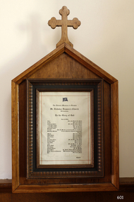
Document - Commemorative, The Victorian Missions to Seamen, St Nicholas Seamen's Church Williamstown, circa 1944
This framed document titled "The Victorian Missions to Seamen, St Nicholas Seamen's Church Williamstown" shows a list of donors of significant items to the St Nicholas Missions to Seamen's Church in Williamstown when the new building opened in 1944. The organisation ceased in 1966 and the furnishings were later donated to Flagstaff Hill Maritime Village in Warrnambool by the Missions to Seamen Victoria. The transcription of the document is as follows: The Victoria Missions to Seamen, St Nicholas Seamen's Church, Williamstown To the Glory of God List of Gifts Altar - Mrs. and Miss J.R. Schutt Cross - Mrs. R.J. Ewart Chalice and Paten - Mr. and Mrs. Percy Taylor 1 Pair Altar Lights - Mrs. R.J. Ewart 1 Pair Altar Lights - Mrs. M. Jackson Sanctuary Lamp - Miss C. Roberts Rerebos - Miss. M. Breaks, in memoriam Miss. L.A. Breaks Sanctuary Window - Victoria Missions to Seamen Lightkeepers' Auxiliary Missal - Mrs. R.J. Ewart Missal Desk - Mrs. R. Hodgkiss Altar Vases - Mrs. R. Kaybould Bible - Mrs. R.J. Ewart Sanctuary Chairs - Mr. and Mrs. F.H. Twist Credence Table - Mrs. F. Clark Altar Dish – Mrs L. Clark Font - Mr. and Mrs. C.V. Dyble Prayer Desk - H.M.H.S. "Centaur" Reed Organ - "Joy Club for Fighters" Collection Plates - Mr. D. MacKae Hymn Board - St. David's Musical Society, Brighton Pews, Carpet and Hangings - Williamstown Lightkeepers' Auxiliary Bell - Mrs. A.L. Feenes THE MISSIONS TO SEAMEN (Brief History: for more, see our Reg. No. 611, Set of Pews) The Missions to Seamen, an Anglican charity, has served seafarers of the world since 1856 in Great Britain. It symbol is a Flying Angel, inspired by a Bible verse. Today there are centr4es in over 200 ports world-wide where seamen of all backgrounds are offered a warm welcome and provided with a wide range of facilities. In Victoria the orgainsation began in Williamstown in 1857. It was as a Sailors’ Church, also known as ‘Bethel’ or the ‘Floating Church’. Its location was an old hulk floating in Hobson’s Bay, Port of Melbourne. It soon became part of the Missions to Seamen, Victoria. In the year 2000 the organisation, now named Mission to Seafarers, still operated locally in Melbourne, Portland, Geelong and Hastings. The Ladies’ Harbour Lights Guild was formed in 1906 to support the Missions to Seamen in Melbourne and other centres such as Williamstown. Two of the most significant ladies of the Guild were founder Ethel Augusta Godfrey and foundation member Alice Sibthorpe Tracy (who established a branch of the Guild in Warrnambool in 1920). The Guild continued its work until the 1960s. In 1943 a former Williamstown bank was purchased for the Missions to Seaman Club. The chapel was named St Nicholas’ Seamen’s Church and was supported by the Ladies’ Harbour Lights Guild, the Williamstown Lightkeepers’ Auxiliary and the League of Soldiers’ and Sailors’ Friends. It ceased operation in 1966. A Missions to Seamen Chapel and Recreation Room was a significant feature of ports during the late 1800s and into the 1900s. It seemed appropriate for Flagstaff Hill to include such a representation within the new Maritime Village, so the Melbourne Board of Management of Missions to Seamen Victoria gave its permission on 21st May 1979 for the entire furnishings of the Williamstown chapel to be transferred to Flagstaff Hill. The St Nicholas Seamen’s Church was officially opened on October 11, 1981 and closely resembles the Williamstown chapel. This document is significant through its association with the St Nicholas' Mission to Seamen Church in Williamstown, Melbourne, established in 1857. The document is socially significant as it connects the community of Williamstown with the St Nicholas' Missions to Seamen and represents the importance of the church to the community. The items in our collection from the Missions to Seamen in Williamstown, Victoria, have historical and social significance. They show that people of the 1800s and 1900s cared about the seafarers’ religious, moral, and social welfare, no matter what the religion, social status or nationality. It had its origins in Bristol, England when a Seamen's Mission was formed in 1837. The first Australian branch was started in 1856 by the Rev. Kerr Johnston, a Church of England clergyman, and operated from a hulk moored in Hobson's Bay; later the Mission occupied buildings in Williamstown and Port Melbourne. Document titled "The Victorian Missions to Seamen, St Nicholas Seamen's Church Williamstown". The document is a list of gifts originally given to the St Nicholas Seaman's Church in Williamstown, Victoria. The document is mounted in a decorative wooden frame with glass cover. This is one of the original items in our ‘St Nicholas Seamen's Church Williamstown Collection’.flagstaff hill, warrnambool, shipwrecked-coast, flagstaff-hill, flagstaff-hill-maritime-museum, maritime-museum, shipwreck-coast, flagstaff-hill-maritime-village, framed document, donations to st nicholas seamen's church williamstown, 139 nelson place williamstown, religion, religious service, sailors rest, bethel sailors’ church, bethel floating church, ladies harbour light guild, mission to seafarers, st nicholas seaman’s church williamstown, mission to seamen williamstown, st nicholas seamen’s church flagstaff hill, flying angel club, mrs. and miss j.r. schutt, mrs. r.j. ewart, mr. and mrs. percy taylor, mrs. m. jackson, miss c. roberts, miss. l.a. breaks, miss. m. breaks, victoria missions to seamen lightkeepers' auxiliary, mrs. r. hodgkiss, mrs. r. kaybould, mr. and mrs. f.h. twist, mrs. f. clark, mrs l. clark, mr. and mrs. c.v. dyble, h.m.h.s. "centaur", "joy club for fighters", mr. d. mackae, williamstown lightkeepers' auxiliary, mrs. a.l. feenes, st. david's musical society brighton -
 Flagstaff Hill Maritime Museum and Village
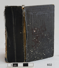
Book - Religious Book, The Book of Common Prayer, 20th century
This book was part of the original furnishings of the St Nicholas' Mission to Seamen's Church at 139 Nelson Place, Williamstown, Victoria. THE MISSIONS TO SEAMEN (Brief History: for more, see our Reg. No. 611, Set of Pews) The Missions to Seamen, an Anglican charity, has served seafarers of the world since 1856 in Great Britain. It symbol is a Flying Angel, inspired by a Bible verse. Today there are centr4es in over 200 ports world-wide where seamen of all backgrounds are offered a warm welcome and provided with a wide range of facilities. In Victoria the orgainsation began in Williamstown in 1857. It was as a Sailors’ Church, also known as ‘Bethel’ or the ‘Floating Church’. Its location was an old hulk floating in Hobson’s Bay, Port of Melbourne. It soon became part of the Missions to Seamen, Victoria. In the year 2000 the organisation, now named Mission to Seafarers, still operated locally in Melbourne, Portland, Geelong and Hastings. The Ladies’ Harbour Lights Guild was formed in 1906 to support the Missions to Seamen in Melbourne and other centres such as Williamstown. Two of the most significant ladies of the Guild were founder Ethel Augusta Godfrey and foundation member Alice Sibthorpe Tracy (who established a branch of the Guild in Warrnambool in 1920). The Guild continued its work until the 1960s. In 1943 a former Williamstown bank was purchased for the Missions to Seaman Club. The chapel was named St Nicholas’ Seamen’s Church and was supported by the Ladies’ Harbour Lights Guild, the Williamstown Lightkeepers’ Auxiliary and the League of Soldiers’ and Sailors’ Friends. It ceased operation in 1966. A Missions to Seamen Chapel and Recreation Room was a significant feature of ports during the late 1800s and into the 1900s. It seemed appropriate for Flagstaff Hill to include such a representation within the new Maritime Village, so the Melbourne Board of Management of Missions to Seamen Victoria gave its permission on 21st May 1979 for the entire furnishings of the Williamstown chapel to be transferred to Flagstaff Hill. The St Nicholas Seamen’s Church was officially opened on October 11, 1981 and closely resembles the Williamstown chapel. This book is significant through its association with the St Nicholas' Mission to Seamen Church in Williamstown, Melbourne, established in 1857. The items in our collection from the Missions to Seamen in Williamstown, Victoria, have historical and social significance. They show that people of the 1800s and 1900s cared about the seafarers’ religious, moral, and social welfare, no matter what the religion, social status or nationality. It had its origins in Bristol, England when a Seamen's Mission was formed in 1837. The first Australian branch was started in 1856 by the Rev. Kerr Johnston, a Church of England clergyman, and operated from a hulk moored in Hobson’s Bay; later the Mission occupied buildings in Williamstown and Port Melbourne. The Book of Common Prayer. Small book, dark fabric hardcovers, both embossed design on cover incorporating a cross. Owner's name written in black ink inside the cover, also four brown stamps of a cross inside cover. Titled "The Book of Common Prayer and Administration of the Sacraments and other Rules and Ceremonies of the CHURCH according to the use of The Church of England". Printed in Great Britain. Book has 730 numbered pages. Inscribed with a signature inside the front cover as well as brown stamps of images of a cross.. This is one of the original items in our St Nicholas Seamen's Church Williamstown Collection.Written in black script inside the front cover "Anne Ambrose". Stamps of a cross symbol, brown ink, on the covers and some of the pages throughout the book. Inside front cover, in pencil, "602" "CH 34" Inside the back cover in blue pen are the numbers "271 / 291 / 24"flagstaff hill, warrnambool, shipwrecked-coast, flagstaff-hill, flagstaff-hill-maritime-museum, maritime-museum, shipwreck-coast, flagstaff-hill-maritime-village, book, prayer book, the book of common prayer, church of england prayer book, anne ambrose, religion, religious service, sailors rest, bethel sailors’ church, bethel floating church, ladies harbour light guild, missions to seamen victoria, mission to seafarers, st nicholas seaman’s church williamstown, st nicholas mission to seamen church williamstown, mission to seamen williamstown, st nicholas seamen’s church flagstaff hill, 139 nelson place williamstown, flying angel club -
 Flagstaff Hill Maritime Museum and Village
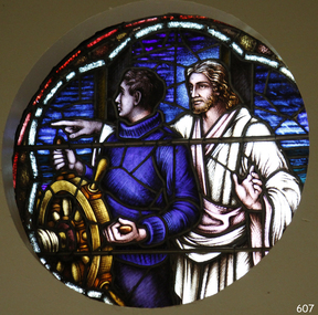
Artwork, other - Window, Brooks, Robinson & Co, Christ Showing the Helmsman the Way, circa August 1947
This round, stained glass window, titled "Christ Showing the Helmsman the Way", was installed in the St Nicholas Seamen's Church at 139 Nelson Place, Williamstown, Victoria. The window was referred to as the Sanctuary Window and was installed in the chapel above the altar. This memorial window has significance as a part of Victoria's War Heritage and is listed on the Victorian Heritage Database. The window was donated to St Nicholas Seamen’s Church as a memorial to the members of the Merchant Navy whose lives were lost in the Second World War, 1939-1945. The donor was the Williamstown Lightkeepers Auxiliary, an independent ladies association working with the Williamstown Missions to Seamen (the Missions to Seamen organisation was re-named the Mission to Seafarers in the year 2000). The window was officially dedicated on December 14, 1947 by Geelong's Anglican Bishop, Rt. Rev. J.D. McKie. In the early months of 1948 a bronze plaque was also placed in the chapel above the altar. It recognises the lost souls of the Merchant Navy during World War 2, as well as the donor of the window, the Williamstown Lightkeepers Auxiliary. The inscription impressed on the rectangular bronze plaque, 20.4 x 10.2cm, is as follows: “IN MEMORY OF THE MEMBERS OF THE MERCHANT NAVY WHO WERE LOST IN THE SECOND WORLD WAR 1939-1945 FAITHFUL UNTO DEATH. THE WINDOW ABOVE THE ALTAR WAS ERECTED BY THE WILLIAMSTOWN LIGHTKEEPERS AUXILIARY 1947.” The Williamstown St Nicholas Seamen’s Church ceased operation in 1966. In 1979 the Victoria Missions to Seamen donated this round, stained glass window and the memorial plaque to Flagstaff Hill Maritime Village, along with many other items and furnishings. These items have been used to simulate the Williamstown Mission and Chapel as much as possible. The round space that formerly displayed the window can still be seen at the back of the old St Nicholas Seamen’s Church, previously the ES&A bank, in Williamstown. THE MISSIONS TO SEAMEN (Brief History: for more, see our Reg. No. 611, Set of Pews) The Missions to Seamen, an Anglican charity, has served seafarers of the world since 1856 in Great Britain. It symbol is a Flying Angel, inspired by a Bible verse. Today there are centr4es in over 200 ports world-wide where seamen of all backgrounds are offered a warm welcome and provided with a wide range of facilities. In Victoria the orgainsation began in Williamstown in 1857. It was as a Sailors’ Church, also known as ‘Bethel’ or the ‘Floating Church’. Its location was an old hulk floating in Hobson’s Bay, Port of Melbourne. It soon became part of the Missions to Seamen, Victoria. In the year 2000 the organisation, now named Mission to Seafarers, still operated locally in Melbourne, Portland, Geelong and Hastings. The Ladies’ Harbour Lights Guild was formed in 1906 to support the Missions to Seamen in Melbourne and other centres such as Williamstown. Two of the most significant ladies of the Guild were founder Ethel Augusta Godfrey and foundation member Alice Sibthorpe Tracy (who established a branch of the Guild in Warrnambool in 1920). The Guild continued its work until the 1960s. In 1943 a former Williamstown bank was purchased for the Missions to Seaman Club. The chapel was named St Nicholas’ Seamen’s Church and was supported by the Ladies’ Harbour Lights Guild, the Williamstown Lightkeepers’ Auxiliary and the League of Soldiers’ and Sailors’ Friends. It ceased operation in 1966. A Missions to Seamen Chapel and Recreation Room was a significant feature of ports during the late 1800s and into the 1900s. It seemed appropriate for Flagstaff Hill to include such a representation within the new Maritime Village, so the Melbourne Board of Management of Missions to Seamen Victoria gave its permission on 21st May 1979 for the entire furnishings of the Williamstown chapel to be transferred to Flagstaff Hill. The St Nicholas Seamen’s Church was officially opened on October 11, 1981 and closely resembles the Williamstown chapel. This stained glass window is significant historically for its origin in the St Nicholas Mission to Seamen's Church in Williamstown, established in 1857 to cater for the physical, social, and spiritual needs of seafarers. It was donated to the Mission by the Lightkeepers Auxiliary (Ladies Harbour Lights Guild, which was formed in 1905). The Missions to Seamen organisation had its origins in Bristol, England when a Seamen's Mission was formed in 1837. The first Australian branch was started in 1856 by the Rev. Kerr Johnston, a Church of England clergyman, and operated from a hulk moored in Hobson’s Bay; later the Mission occupied buildings in Williamstown and Port Melbourne. The connection of this window the Mission to Seamen and the Ladies Harbour Lights Guild highlights the strong community awareness of the life of people at sea, their dangers and hardships, and their need for physical, financial, spiritual and moral support. This memorial window has significant as a part of Victoria's War Heritage and is listed on the Victorian Heritage Database, Heritage Number 196973.Window, stained glass, circular, with reinforcing bars. The window represents Christ showing the helmsman the way. It shows a man in blue knitted jumper holding onto a ship's wheel, looking over his right shoulder. Behind him stands a man in a white robe pointing to his right and looking to his left, his left hand gesturing to pause. The background has various shapes and patterns of blue glass, bordered by two arcs, the outer one is white, the inner one is red. This beautiful window is in our St Nicholas Seamen's Church Collection and was brought to Warrnambool from the original St Nicholas Seamen’s Church in Williamstown. flagstaff hill, warrnambool, shipwrecked coast, flagstaff hill maritime museum, maritime museum, shipwreck coast, flagstaff hill maritime village, great ocean road, mission to seamen williamstown, st nicholas seaman’s church williamstown, missions to seamen victoria, mission to seafarers, lightkeepers auxiliary, ladies harbour light guild, 139 nelson place williamstown, religion, religious service, sailors rest, bethel sailors’ church, bethel floating church, e. s. & a. bank williamstown, christ directing a sailor, christ showing the helmsman the way, quartermaster’s hand on the wheel, stained glass window, church window, religious window, sanctuary window, memorial window, war memorial window, victorian war heritage inventory, victorian heritage database, merchant navy ww2, 1939-1945, anglican church, bishop mckie, mrs musther, brooks robinson & co, flying angel club, williamstown lightkeepers' auxiliary, ladies' harbour lights guild, commemorative window -
 Flagstaff Hill Maritime Museum and Village
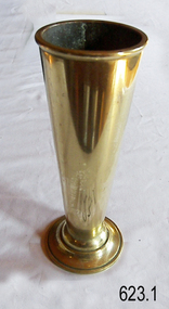
Functional object - Vase, circa 1944
This vase, one of a part of a pair of organ vases, was part of the original furnishings of the St Nicholas' Mission to Seamen's Church at 139 Nelson Place, Williamstown, Victoria. THE MISSIONS TO SEAMEN (Brief History: for more, see our Reg. No. 611, Set of Pews) The Missions to Seamen, an Anglican charity, has served seafarers of the world since 1856 in Great Britain. It symbol is a Flying Angel, inspired by a Bible verse. Today there are centr4es in over 200 ports world-wide where seamen of all backgrounds are offered a warm welcome and provided with a wide range of facilities. In Victoria the orgainsation began in Williamstown in 1857. It was as a Sailors’ Church, also known as ‘Bethel’ or the ‘Floating Church’. Its location was an old hulk floating in Hobson’s Bay, Port of Melbourne. It soon became part of the Missions to Seamen, Victoria. In the year 2000 the organisation, now named Mission to Seafarers, still operated locally in Melbourne, Portland, Geelong and Hastings. The Ladies’ Harbour Lights Guild was formed in 1906 to support the Missions to Seamen in Melbourne and other centres such as Williamstown. Two of the most significant ladies of the Guild were founder Ethel Augusta Godfrey and foundation member Alice Sibthorpe Tracy (who established a branch of the Guild in Warrnambool in 1920). The Guild continued its work until the 1960s. In 1943 a former Williamstown bank was purchased for the Missions to Seaman Club. The chapel was named St Nicholas’ Seamen’s Church and was supported by the Ladies’ Harbour Lights Guild, the Williamstown Lightkeepers’ Auxiliary and the League of Soldiers’ and Sailors’ Friends. It ceased operation in 1966. A Missions to Seamen Chapel and Recreation Room was a significant feature of ports during the late 1800s and into the 1900s. It seemed appropriate for Flagstaff Hill to include such a representation within the new Maritime Village, so the Melbourne Board of Management of Missions to Seamen Victoria gave its permission on 21st May 1979 for the entire furnishings of the Williamstown chapel to be transferred to Flagstaff Hill. The St Nicholas Seamen’s Church was officially opened on October 11, 1981 and closely resembles the Williamstown chapel. This vase, and its pair, is significant through its association with the St Nicholas' Mission to Seamen Church in Williamstown, Melbourne, established in 1857. The items in our collection from the Missions to Seamen in Williamstown, Victoria, have historical and social significance. They show that people of the 1800s and 1900s cared about the seafarers’ religious, moral, and social welfare, no matter what the religion, social status or nationality. It had its origins in Bristol, England when a Seamen's Mission was formed in 1837. The first Australian branch was started in 1856 by the Rev. Kerr Johnston, a Church of England clergyman, and operated from a hulk moored in Hobson’s Bay; later the Mission occupied buildings in Williamstown and Port Melbourne. Vase, one of a pair, of organ vases, polished brass church vases with truncated conical shapes. White sticker under vase with hand written number "136" This is one of the original items in our ‘St Nicholas Seamen's Church Williamstown Collection’.White sticker under vase with hand written number "136" flagstaff hill, warrnambool, shipwrecked-coast, flagstaff-hill, flagstaff-hill-maritime-museum, maritime-museum, shipwreck-coast, flagstaff-hill-maritime-village, vase, church vase, brass vase, conical vase, religion, religious service, sailors rest, bethel sailors’ church, bethel floating church, ladies harbour light guild, missions to seamen victoria, mission to seafarers, st nicholas seaman’s church williamstown, st nicholas mission to seamen church williamstown, mission to seamen williamstown, st nicholas seamen’s church flagstaff hill, 139 nelson place williamstown, flying angel club, organ vase -
 Flagstaff Hill Maritime Museum and Village
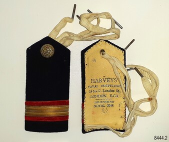
Badge - Epaulette, Harvey's Naval Outfitters, 1920s
The pair of epaulettes once belonged to W.R. Angus, who possibly wore them when he worked his passage to and from the UK in the 1920s. The button on each has an unidentified emblem. They are part of Flagstaff Hill’s comprehensive W.R. Angus Collection, donated by the family of Dr W R Angus (1901-1970), surgeon and oculist. The ties, which look like shoe laces, would secure the epaulettes to the uniform's shoulders. The epaulettes were made by Harvey's Naval Outfitters of 15-16-17 London Street, London, E.C.3, in the East Central area of London. Another of the firm's addresses is Leadenhall Street, London, named the 'centre of commerce'. East India Company and Pacific & Oriental Steam Navigation Company (P&O) once had their headquarters there. The postcode 'EC3' dates back to 1917 when the postcode system was established in the United Kingdom. William Roy Angus (1901-1970) qualified as a doctor in 1923. He decided he further his studies overseas in the UK in 1927, sailing on the ship SS Banffshire (built in 1912, destroyed in 1937). He studied at London University College Hospital and Edinburgh Royal Infirmary and in 1928 he was awarded FRCS (Fellow from the Royal College of Surgeons), Edinburgh, Scotland. He worked his passage back to Australia as a Ship’s Surgeon on the Australian Commonwealth Line T.S.S. Largs Bay, purchased by the White Star Line in 1928. Dr W R Angus was a Surgeon Captain for the Australian Defence Forces, Army Medical Corps, stationed in Ballarat, Victoria, and in Bonegilla, N.S.W. He completed his service just before the end of the war due to suffering from a heart attack. The W.R. Angus Collection: - The W.R. Angus Collection includes historical medical equipment, surgical instruments and material belonging to Dr Edward Ryan and Dr Thomas Francis Ryan, (both of Nhill, Victoria) and Dr Angus’ own belongings. The Collection’s history spans the medical practices of the two Doctors Ryan, from 1885-1926 plus that of Dr Angus, up until 1969. It includes historical medical and surgical equipment and instruments from the doctors Edward and Thomas Ryan of Nhill, Victoria. Dr Angus married Gladys in 1927 at Ballarat, the nearest big city to Nhill where he began as a Medical Assistant. He was also Acting House surgeon at the Nhill hospital where their two daughters were born. During World War II He served as a Military Doctor in the Australian Defence Forces. Dr Angus and his family moved to Warrnambool in 1939, where Dr Angus operated his own medical practice. He later added the part-time Port Medical Officer responsibility and was the last person appointed to that position. Dr Angus and his wife were very involved in the local community, including the new Flagstaff Hill's planning stages and the gardens' layout. Dr Angus passed away in March 1970.This pair of epaulettes is connected to the badges in the W.R. Angus Collection. Dr W R Angus (1901-1970), surgeon and oculist, collected a range of badges and military objects including those he personally used during his time as Surgeon Captain in the Australian Defence Forces in World War II. The W.R. Angus Collection is significant for still being located at the site it is connected with, Doctor Angus being the last Port Medical Officer in Warrnambool. The Collection includes historical medical objects that date back to the late 1800s.Epaulette (pair of two), dark blue with red and gold horizontal stripes, with a gold-coloured button and woven white web ties. A tall rectangular shape with a point at the top. Made from a card base, covered by dark blue fabric and a hand-stitched lining of cream-coloured leather, stamped with the maker's details. The button has an inscripton and image. Made by Harvey's Outfitters in London. The button has images and text. The epaulettes belonged to Dr W R Angus and are now part of the W. R. Angus Collection.“HARVEYS’ / NAVAL OUTFITTERS / 15-16-17, London St / LONDON E.C.3. / TELEPHONE / ROYAL 3248” Button; Inscription and image [indecipherable] Button is embossed with images (anchor, serpent, flag) and text "B. 'G. "flagstaff hill, warrnambool, maritime village, maritime museum, shipwreck coast, great ocean road, flagstaff hill maritime museum and village, dr w r angus, w.r. angus collection, badge, insignia, badge collection, epaulettes, naval epaulettes, naval insignia, shoulder boards, ss banffshire, t.s.s. largs bay, uniform, harvey's naval outfitters, london street london -
 Eltham District Historical Society Inc
Photograph, Hume and Hovell Monument, Broadford, Autumn Excursion, Hume and Hovell's 1824 expedition, 26 May 1996, 26/05/1996
[article by Bettina Woodburn in EDHS Newsletter No. 109, July 1996:] ON THE TRAIL OF HUME AND HOVELL - REPORT ON THE AUTUMN EXCURSION - On a green and fresh morning (Sunday 26th May 1996) the Cobb and Co coach (driven by the most obliging Peter Tampion) set off in a north easterly direction from Eltham to connect with Hume and Hovell's route on their 1824 explorations of central Victoria. The Society would follow a series of monuments erected for the 1924 centenary of the expedition from King Parrot Creek (Tuesday 7th December 1824), through Strath Creek, over Sunday Creek (Sunday 12th December 1824) at Broadford, Tullamarine, St Albans, Deer Park, through Werribee, skirting east of the You Yangs to Lara and Avalon Beach. Because their distance-measuring wheel had broken and a one degree mistake was made in calculations, the two leaders of the original group of six convict-companions arrived at Corio Bay, instead of the expected Western Port, discovered earlier by Flinders. From below Mt. Disappointment (Hume and Hovell's difficulties in "scrambling over brush and rock", "leeches in forest, as well as no water", "cutting grass 4-5 ft. high", dreadful scrub", "devil flies") we took an easier route, saw the Strath Creek memorial in ground fog and a wonderful "field of dreams", the Hume-Hovell privately owned cricket ground with its white picket boundary fence. Now, after a steep climb, in sunshine under gums we stretched and viewed magnificent rolling hills and fog-filled valleys - not "smoke from Aborigines' bush fires". After morning tea at Broadford we followed the Sunday Creek valley beside the Hume Freeway, passed the Wallan Wallan Rest Area (more appropriately Hume and Hovell Rest Area) to tum right at Beveridge. In Gellibrand Hill Park, near the headwaters of the Moonee Ponds Creek, we experienced the landscape the first European settlers saw - huge river red gums and rolling pastures. The gardens and sheltered courtyard of the 1840s, timber, brought from .....[?] prefabricated Woodlands Homestead, provided a pleasant lunch stop. We enjoyed a private tour, panoramic views over Melbourne and surroundings and the excitement of arriving and departing aircraft. Our next river crossing was at Werribee, "in a vast treeless plain", then we drove on by-ways no coach had previously travelled, to find "an immense sheet of water" salty Corio Bay, off-course to the west. In late afternoon of a super, calm, late autumn day we headed homewards. Back at Eltham we were rather surprised to find that we had travelled a total of 347 km. Thanks again to Russell Yeoman for his research and organization. What a wonderful day! Colour photographactivities, broadford, hume and hovell, monument -
 Eltham District Historical Society Inc
Photograph, Strath Creek, Autumn Excursion, Hume and Hovell's 1824 expedition, 26 May 1996, 26/05/1996
[article by Bettina Woodburn in EDHS Newsletter No. 109, July 1996:] ON THE TRAIL OF HUME AND HOVELL - REPORT ON THE AUTUMN EXCURSION - On a green and fresh morning (Sunday 26th May 1996) the Cobb and Co coach (driven by the most obliging Peter Tampion) set off in a north easterly direction from Eltham to connect with Hume and Hovell's route on their 1824 explorations of central Victoria. The Society would follow a series of monuments erected for the 1924 centenary of the expedition from King Parrot Creek (Tuesday 7th December 1824), through Strath Creek, over Sunday Creek (Sunday 12th December 1824) at Broadford, Tullamarine, St Albans, Deer Park, through Werribee, skirting east of the You Yangs to Lara and Avalon Beach. Because their distance-measuring wheel had broken and a one degree mistake was made in calculations, the two leaders of the original group of six convict-companions arrived at Corio Bay, instead of the expected Western Port, discovered earlier by Flinders. From below Mt. Disappointment (Hume and Hovell's difficulties in "scrambling over brush and rock", "leeches in forest, as well as no water", "cutting grass 4-5 ft. high", dreadful scrub", "devil flies") we took an easier route, saw the Strath Creek memorial in ground fog and a wonderful "field of dreams", the Hume-Hovell privately owned cricket ground with its white picket boundary fence. Now, after a steep climb, in sunshine under gums we stretched and viewed magnificent rolling hills and fog-filled valleys - not "smoke from Aborigines' bush fires". After morning tea at Broadford we followed the Sunday Creek valley beside the Hume Freeway, passed the Wallan Wallan Rest Area (more appropriately Hume and Hovell Rest Area) to tum right at Beveridge. In Gellibrand Hill Park, near the headwaters of the Moonee Ponds Creek, we experienced the landscape the first European settlers saw - huge river red gums and rolling pastures. The gardens and sheltered courtyard of the 1840s, timber, brought from .....[?] prefabricated Woodlands Homestead, provided a pleasant lunch stop. We enjoyed a private tour, panoramic views over Melbourne and surroundings and the excitement of arriving and departing aircraft. Our next river crossing was at Werribee, "in a vast treeless plain", then we drove on by-ways no coach had previously travelled, to find "an immense sheet of water" salty Corio Bay, off-course to the west. In late afternoon of a super, calm, late autumn day we headed homewards. Back at Eltham we were rather surprised to find that we had travelled a total of 347 km. Thanks again to Russell Yeoman for his research and organization. What a wonderful day! Colour photographactivities, monument, hume and hovell, murchison valley, strath creek -
 Eltham District Historical Society Inc
Photograph, Murchison Gap viewed from Strath Creek, Autumn Excursion, Hume and Hovell's 1824 expedition, 26 May 1996, 26/05/1996
[article by Bettina Woodburn in EDHS Newsletter No. 109, July 1996:] ON THE TRAIL OF HUME AND HOVELL - REPORT ON THE AUTUMN EXCURSION - On a green and fresh morning (Sunday 26th May 1996) the Cobb and Co coach (driven by the most obliging Peter Tampion) set off in a north easterly direction from Eltham to connect with Hume and Hovell's route on their 1824 explorations of central Victoria. The Society would follow a series of monuments erected for the 1924 centenary of the expedition from King Parrot Creek (Tuesday 7th December 1824), through Strath Creek, over Sunday Creek (Sunday 12th December 1824) at Broadford, Tullamarine, St Albans, Deer Park, through Werribee, skirting east of the You Yangs to Lara and Avalon Beach. Because their distance-measuring wheel had broken and a one degree mistake was made in calculations, the two leaders of the original group of six convict-companions arrived at Corio Bay, instead of the expected Western Port, discovered earlier by Flinders. From below Mt. Disappointment (Hume and Hovell's difficulties in "scrambling over brush and rock", "leeches in forest, as well as no water", "cutting grass 4-5 ft. high", dreadful scrub", "devil flies") we took an easier route, saw the Strath Creek memorial in ground fog and a wonderful "field of dreams", the Hume-Hovell privately owned cricket ground with its white picket boundary fence. Now, after a steep climb, in sunshine under gums we stretched and viewed magnificent rolling hills and fog-filled valleys - not "smoke from Aborigines' bush fires". After morning tea at Broadford we followed the Sunday Creek valley beside the Hume Freeway, passed the Wallan Wallan Rest Area (more appropriately Hume and Hovell Rest Area) to tum right at Beveridge. In Gellibrand Hill Park, near the headwaters of the Moonee Ponds Creek, we experienced the landscape the first European settlers saw - huge river red gums and rolling pastures. The gardens and sheltered courtyard of the 1840s, timber, brought from .....[?] prefabricated Woodlands Homestead, provided a pleasant lunch stop. We enjoyed a private tour, panoramic views over Melbourne and surroundings and the excitement of arriving and departing aircraft. Our next river crossing was at Werribee, "in a vast treeless plain", then we drove on by-ways no coach had previously travelled, to find "an immense sheet of water" salty Corio Bay, off-course to the west. In late afternoon of a super, calm, late autumn day we headed homewards. Back at Eltham we were rather surprised to find that we had travelled a total of 347 km. Thanks again to Russell Yeoman for his research and organization. What a wonderful day! Colour photographactivities, hume and hovell, murchison valley, murchison gap, strath creek -
 Eltham District Historical Society Inc
Photograph, Autumn Excursion, Hume and Hovell's 1824 expedition, 26 May 1996, 26/05/1996
[article by Bettina Woodburn in EDHS Newsletter No. 109, July 1996:] ON THE TRAIL OF HUME AND HOVELL - REPORT ON THE AUTUMN EXCURSION - On a green and fresh morning (Sunday 26th May 1996) the Cobb and Co coach (driven by the most obliging Peter Tampion) set off in a north easterly direction from Eltham to connect with Hume and Hovell's route on their 1824 explorations of central Victoria. The Society would follow a series of monuments erected for the 1924 centenary of the expedition from King Parrot Creek (Tuesday 7th December 1824), through Strath Creek, over Sunday Creek (Sunday 12th December 1824) at Broadford, Tullamarine, St Albans, Deer Park, through Werribee, skirting east of the You Yangs to Lara and Avalon Beach. Because their distance-measuring wheel had broken and a one degree mistake was made in calculations, the two leaders of the original group of six convict-companions arrived at Corio Bay, instead of the expected Western Port, discovered earlier by Flinders. From below Mt. Disappointment (Hume and Hovell's difficulties in "scrambling over brush and rock", "leeches in forest, as well as no water", "cutting grass 4-5 ft. high", dreadful scrub", "devil flies") we took an easier route, saw the Strath Creek memorial in ground fog and a wonderful "field of dreams", the Hume-Hovell privately owned cricket ground with its white picket boundary fence. Now, after a steep climb, in sunshine under gums we stretched and viewed magnificent rolling hills and fog-filled valleys - not "smoke from Aborigines' bush fires". After morning tea at Broadford we followed the Sunday Creek valley beside the Hume Freeway, passed the Wallan Wallan Rest Area (more appropriately Hume and Hovell Rest Area) to tum right at Beveridge. In Gellibrand Hill Park, near the headwaters of the Moonee Ponds Creek, we experienced the landscape the first European settlers saw - huge river red gums and rolling pastures. The gardens and sheltered courtyard of the 1840s, timber, brought from .....[?] prefabricated Woodlands Homestead, provided a pleasant lunch stop. We enjoyed a private tour, panoramic views over Melbourne and surroundings and the excitement of arriving and departing aircraft. Our next river crossing was at Werribee, "in a vast treeless plain", then we drove on by-ways no coach had previously travelled, to find "an immense sheet of water" salty Corio Bay, off-course to the west. In late afternoon of a super, calm, late autumn day we headed homewards. Back at Eltham we were rather surprised to find that we had travelled a total of 347 km. Thanks again to Russell Yeoman for his research and organization. What a wonderful day! Colour photographactivities, hume and hovell -
 Eltham District Historical Society Inc
Photograph, Sign to Hume and Hovell Cricket Ground, at Allandale Road, Strath Creek, Autumn Excursion, Hume and Hovell's 1824 expedition, 26 May 1996, 26/05/1996
[article by Bettina Woodburn in EDHS Newsletter No. 109, July 1996:] ON THE TRAIL OF HUME AND HOVELL - REPORT ON THE AUTUMN EXCURSION - On a green and fresh morning (Sunday 26th May 1996) the Cobb and Co coach (driven by the most obliging Peter Tampion) set off in a north easterly direction from Eltham to connect with Hume and Hovell's route on their 1824 explorations of central Victoria. The Society would follow a series of monuments erected for the 1924 centenary of the expedition from King Parrot Creek (Tuesday 7th December 1824), through Strath Creek, over Sunday Creek (Sunday 12th December 1824) at Broadford, Tullamarine, St Albans, Deer Park, through Werribee, skirting east of the You Yangs to Lara and Avalon Beach. Because their distance-measuring wheel had broken and a one degree mistake was made in calculations, the two leaders of the original group of six convict-companions arrived at Corio Bay, instead of the expected Western Port, discovered earlier by Flinders. From below Mt. Disappointment (Hume and Hovell's difficulties in "scrambling over brush and rock", "leeches in forest, as well as no water", "cutting grass 4-5 ft. high", dreadful scrub", "devil flies") we took an easier route, saw the Strath Creek memorial in ground fog and a wonderful "field of dreams", the Hume-Hovell privately owned cricket ground with its white picket boundary fence. Now, after a steep climb, in sunshine under gums we stretched and viewed magnificent rolling hills and fog-filled valleys - not "smoke from Aborigines' bush fires". After morning tea at Broadford we followed the Sunday Creek valley beside the Hume Freeway, passed the Wallan Wallan Rest Area (more appropriately Hume and Hovell Rest Area) to tum right at Beveridge. In Gellibrand Hill Park, near the headwaters of the Moonee Ponds Creek, we experienced the landscape the first European settlers saw - huge river red gums and rolling pastures. The gardens and sheltered courtyard of the 1840s, timber, brought from .....[?] prefabricated Woodlands Homestead, provided a pleasant lunch stop. We enjoyed a private tour, panoramic views over Melbourne and surroundings and the excitement of arriving and departing aircraft. Our next river crossing was at Werribee, "in a vast treeless plain", then we drove on by-ways no coach had previously travelled, to find "an immense sheet of water" salty Corio Bay, off-course to the west. In late afternoon of a super, calm, late autumn day we headed homewards. Back at Eltham we were rather surprised to find that we had travelled a total of 347 km. Thanks again to Russell Yeoman for his research and organization. What a wonderful day! Colour photographactivities, hume and hovell, allandale road, strath creek -
 Eltham District Historical Society Inc
Photograph, Autumn Excursion, Hume and Hovell's 1824 expedition, 26 May 1996, 26/05/1996
[article by Bettina Woodburn in EDHS Newsletter No. 109, July 1996:] ON THE TRAIL OF HUME AND HOVELL - REPORT ON THE AUTUMN EXCURSION - On a green and fresh morning (Sunday 26th May 1996) the Cobb and Co coach (driven by the most obliging Peter Tampion) set off in a north easterly direction from Eltham to connect with Hume and Hovell's route on their 1824 explorations of central Victoria. The Society would follow a series of monuments erected for the 1924 centenary of the expedition from King Parrot Creek (Tuesday 7th December 1824), through Strath Creek, over Sunday Creek (Sunday 12th December 1824) at Broadford, Tullamarine, St Albans, Deer Park, through Werribee, skirting east of the You Yangs to Lara and Avalon Beach. Because their distance-measuring wheel had broken and a one degree mistake was made in calculations, the two leaders of the original group of six convict-companions arrived at Corio Bay, instead of the expected Western Port, discovered earlier by Flinders. From below Mt. Disappointment (Hume and Hovell's difficulties in "scrambling over brush and rock", "leeches in forest, as well as no water", "cutting grass 4-5 ft. high", dreadful scrub", "devil flies") we took an easier route, saw the Strath Creek memorial in ground fog and a wonderful "field of dreams", the Hume-Hovell privately owned cricket ground with its white picket boundary fence. Now, after a steep climb, in sunshine under gums we stretched and viewed magnificent rolling hills and fog-filled valleys - not "smoke from Aborigines' bush fires". After morning tea at Broadford we followed the Sunday Creek valley beside the Hume Freeway, passed the Wallan Wallan Rest Area (more appropriately Hume and Hovell Rest Area) to tum right at Beveridge. In Gellibrand Hill Park, near the headwaters of the Moonee Ponds Creek, we experienced the landscape the first European settlers saw - huge river red gums and rolling pastures. The gardens and sheltered courtyard of the 1840s, timber, brought from .....[?] prefabricated Woodlands Homestead, provided a pleasant lunch stop. We enjoyed a private tour, panoramic views over Melbourne and surroundings and the excitement of arriving and departing aircraft. Our next river crossing was at Werribee, "in a vast treeless plain", then we drove on by-ways no coach had previously travelled, to find "an immense sheet of water" salty Corio Bay, off-course to the west. In late afternoon of a super, calm, late autumn day we headed homewards. Back at Eltham we were rather surprised to find that we had travelled a total of 347 km. Thanks again to Russell Yeoman for his research and organization. What a wonderful day! Colour photographactivities, hume and hovell -
 Eltham District Historical Society Inc
Photograph, Autumn Excursion, Hume and Hovell's 1824 expedition, 26 May 1996, 26/05/1996
[article by Bettina Woodburn in EDHS Newsletter No. 109, July 1996:] ON THE TRAIL OF HUME AND HOVELL - REPORT ON THE AUTUMN EXCURSION - On a green and fresh morning (Sunday 26th May 1996) the Cobb and Co coach (driven by the most obliging Peter Tampion) set off in a north easterly direction from Eltham to connect with Hume and Hovell's route on their 1824 explorations of central Victoria. The Society would follow a series of monuments erected for the 1924 centenary of the expedition from King Parrot Creek (Tuesday 7th December 1824), through Strath Creek, over Sunday Creek (Sunday 12th December 1824) at Broadford, Tullamarine, St Albans, Deer Park, through Werribee, skirting east of the You Yangs to Lara and Avalon Beach. Because their distance-measuring wheel had broken and a one degree mistake was made in calculations, the two leaders of the original group of six convict-companions arrived at Corio Bay, instead of the expected Western Port, discovered earlier by Flinders. From below Mt. Disappointment (Hume and Hovell's difficulties in "scrambling over brush and rock", "leeches in forest, as well as no water", "cutting grass 4-5 ft. high", dreadful scrub", "devil flies") we took an easier route, saw the Strath Creek memorial in ground fog and a wonderful "field of dreams", the Hume-Hovell privately owned cricket ground with its white picket boundary fence. Now, after a steep climb, in sunshine under gums we stretched and viewed magnificent rolling hills and fog-filled valleys - not "smoke from Aborigines' bush fires". After morning tea at Broadford we followed the Sunday Creek valley beside the Hume Freeway, passed the Wallan Wallan Rest Area (more appropriately Hume and Hovell Rest Area) to tum right at Beveridge. In Gellibrand Hill Park, near the headwaters of the Moonee Ponds Creek, we experienced the landscape the first European settlers saw - huge river red gums and rolling pastures. The gardens and sheltered courtyard of the 1840s, timber, brought from .....[?] prefabricated Woodlands Homestead, provided a pleasant lunch stop. We enjoyed a private tour, panoramic views over Melbourne and surroundings and the excitement of arriving and departing aircraft. Our next river crossing was at Werribee, "in a vast treeless plain", then we drove on by-ways no coach had previously travelled, to find "an immense sheet of water" salty Corio Bay, off-course to the west. In late afternoon of a super, calm, late autumn day we headed homewards. Back at Eltham we were rather surprised to find that we had travelled a total of 347 km. Thanks again to Russell Yeoman for his research and organization. What a wonderful day! Colour photographactivities, hume and hovell -
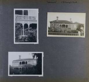
 Glen Eira Historical Society
Album - Album page, Hotham Street, Circa 1972
This photograph is part of the Caulfield Historical Album 1972. This album was created in approximately 1972 as part of a project by the Caulfield Historical Society to assist in identifying buildings worthy of preservation. The album is related to a Survey the Caulfield Historical Society developed in collaboration with the National Trust of Australia (Victoria) and Caulfield City Council to identify historic buildings within the City of Caulfield that warranted the protection of a National Trust Classification. Principal photographer thought to be Trevor Hart, member of Caulfield Historical Society. Most photographs were taken between 1966-1972 with a small number of photographs being older and from unknown sources. All photographs are black and white except where stated, with 386 photographs over 198 pages.Victorian Heritage Database - Hotham Street Road Overbridge HO116 Heritage Overlay - City of Glen Eira https://vhd.heritagecouncil.vic.gov.au/places/43557 (as of 04/07/2021) The Hotham Street road overbridge is located on the Sandringham railway line between Ripponlea and Elsternwick railway stations. It is presumed to have been built by contractors Sharp and Campbell who signed a contract on 25th . November, 1881 to construct a second line of railway between Windsor and Elsternwick. This contract was completed during 1882 and the bridge may have been designed in the year when Robert Watson took over from William Elsdon as engineer in chief for the Victorian railways. It is historically, aesthetically and technically significant. It is historically significant (Criterion A) to the extent that it demonstrates the standards of construction adopted by the Victorian Railways Department when it rebuilt the lines acquired from the private railway companies, (compare the Geelong and Melbourne Railway Co's line from Newport to Geelong, acquired in 1860). It is aesthetically significant (Criterion E) as an intact nineteenth century structure of its type, many similar girder bridges having been renewed with concrete girders in recent years. The bluestone abutments demonstrate high standards of stone masonry and are representative of Departmental work of the period. This bridge forms one of a group of historic structures on the railway to Brighton Beach and therefore contributes to the line's cultural importance as a whole. The survival of the riveted iron girders with their bellied angle iron struts is important since these elements are representative of the civil engineering practices of the Victorian Railways at the time and constitute the technical significance (Criterion F) of the structure.Page 96 of Photograph Album with three photographs (one portrait and two landscape) from Hotham Street - two external views of one house and a railway bridge.Handwritten: Hotham Street [top right] / 112 HOTHAM ST [under top left photo] / BRIDGE OVER SANDRINGHAM RAILWAY [under top right photo] / 112 HOTHAM ST CNR MELBY AVE [under bottom left photo] / 96 [bottom right]trevor hart, elsternwick, hotham street, caulfield, houses, brick, bay windows, verandahs, railway bridges, tunnels, gardens, bluestone, civil engineering, victorian railways, sharp and campbell, contractors -
 Glen Eira Historical Society
Album - Album page, 31 Nepean Highway, Circa 1972
This photograph is part of the Caulfield Historical Album 1972. This album was created in approximately 1972 as part of a project by the Caulfield Historical Society to assist in identifying buildings worthy of preservation. The album is related to a Survey the Caulfield Historical Society developed in collaboration with the National Trust of Australia (Victoria) and Caulfield City Council to identify historic buildings within the City of Caulfield that warranted the protection of a National Trust Classification. Principal photographer thought to be Trevor Hart, member of Caulfield Historical Society. Most photographs were taken between 1966-1972 with a small number of photographs being older and from unknown sources. All photographs are black and white except where stated, with 386 photographs over 198 pages. Victorian Heritage Database - HO48 - 31 Nepean Highway Elsternwick https://vhd.heritagecouncil.vic.gov.au/places/35531 (at 15/08/2021) "Roseneath" at 31 Point Nepean Road is a bi-chromatic Italianate villa built for William Millar in 1874. It is aesthetically and historically important. "Roseneath's aesthetic value derives from its survival as a substantially intact bi-chromatic brick villa, distinguished by the symmetrical north and south facing bays and by its spacious grounds. Its historical value rests on its comparatively early date and link with Shire councillor William Millar. The choice of bi-chromatic brick, which was highly fashionable at the time, is also of note. "Roseneath" compares with "Cumbernauld" (pre 1872) at 504 Hawthorn Road and "Glenmoore" (1870) at 1 St Georges Road.Page 140 of Photograph Album with three (landscape) photographs of Roseneath on Nepean Highway. Handwritten: 31 Nepean Highway [top right] / 140 [bottom right]trevor hart, verandah, chimneys, porch, decorative brackets, single storey, cast iron columns, return verandah, garden, nepean highway, roseneath, italianate, 1870's, elsternwick, cast iron work, victorian style, polychrome bricks, william millar, slate roofs, brick houses, house names -
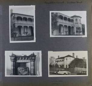
 Glen Eira Historical Society
Album - Album page, 84 Orrong Crescent, Circa 1972
This photograph is part of the Caulfield Historical Album 1972. This album was created in approximately 1972 as part of a project by the Caulfield Historical Society to assist in identifying buildings worthy of preservation. The album is related to a Survey the Caulfield Historical Society developed in collaboration with the National Trust of Australia (Victoria) and Caulfield City Council to identify historic buildings within the City of Caulfield that warranted the protection of a National Trust Classification. Principal photographer thought to be Trevor Hart, member of Caulfield Historical Society. Most photographs were taken between 1966-1972 with a small number of photographs being older and from unknown sources. All photographs are black and white except where stated, with 386 photographs over 198 pages. From Victorian Heritage Database citation for 84 Orrong Crescent https://vhd.heritagecouncil.vic.gov.au/places/35584 as at (28/10/2020) "St. Reliers" at 84 Orrong Crescent is important as an unusually excessively enriched asymmetrical villa residence of the Boom period. From Victorian Heritage Database citation for HO50 84 Orrong Crescent Caulfield North https://vhd.heritagecouncil.vic.gov.au/places/35584 as at (28/10/2020) An imposing Italianate two storeyed asymmetrical villa with overpainted stuccoed surfaces to the facade, distinguished by their ornate treatment. Unusually rich ornamentation includes the acanthus leaf impost capitals, aedicules with swags and volutes, foliated panels to the frieze, ashlar treatment to the lower level and quoins above. The two storeyed cast iron verandah with timber frieze rail protects a black and white tiled floor. The hipped roof has patterned slates.Page 152 of Photograph Album with two landscape photographs of Bonhurst on Orrong Crescent.Handwritten: 84 Orrong Crescent [top right] / NOW 84 - PREVIOUSLY 120 ORRONG CRESCENT / "BONHURST" [under bottom photo] / 152 [bottom right]trevor hart, verandah, porch, slate roof, garden, decorative brackets, fanlight, protruding bay, bay window, garden lamp, asymmetrical, bonhurst, st reliers, rendered, orrong crescent, caulfield north, cast iron work, victorian style, mansions, house names, slate roofs, italianate style -
 Glen Eira Historical Society
Album - Album page, St Joseph's Presbytery, Orrong Road, Circa 1972
This photograph is part of the Caulfield Historical Album 1972. This album was created in approximately 1972 as part of a project by the Caulfield Historical Society to assist in identifying buildings worthy of preservation. The album is related to a Survey the Caulfield Historical Society developed in collaboration with the National Trust of Australia (Victoria) and Caulfield City Council to identify historic buildings within the City of Caulfield that warranted the protection of a National Trust Classification. Principal photographer thought to be Trevor Hart, member of Caulfield Historical Society. Most photographs were taken between 1966-1972 with a small number of photographs being older and from unknown sources. All photographs are black and white except where stated, with 386 photographs over 198 pages. St Joseph's buildings and grounds are contributory properties to HO72 Elsternwick Estate and environs - City of Glen Eira.Page 162 - two photographs of St Joseph's Presbytery, Orrong Road.Handwritten: St Joseph's Presbytery Orrong Road [top right] / PREVIOUSLY "THE EMS" 1908 [under left photo] / 162 [bottom right]trevor hart, orrong road, curved windows, decorative brackets, arched windows, bay window, portico, slate roof, st joseph's presbytery, catholic church, st joseph's church, st joseph's primary school, porte cochere, the ems, elsternwick, rendered walls, clergy residences, drives, late victorian style, house names -
 Glen Eira Historical Society
Album - Album page, Glenmoore, St George's Road, Circa 1972
This photograph is part of the Caulfield Historical Album 1972. This album was created in approximately 1972 as part of a project by the Caulfield Historical Society to assist in identifying buildings worthy of preservation. The album is related to a Survey the Caulfield Historical Society developed in collaboration with the National Trust of Australia (Victoria) and Caulfield City Council to identify historic buildings within the City of Caulfield that warranted the protection of a National Trust Classification. Principal photographer thought to be Trevor Hart, member of Caulfield Historical Society. Most photographs were taken between 1966-1972 with a small number of photographs being older and from unknown sources. All photographs are black and white except where stated, with 386 photographs over 198 pages. From Victorian Heritage Database citation for HO59 Glenmoore, 1 St Georges Road Elsternwick https://vhd.heritagecouncil.vic.gov.au/places/35202 as at 30/10/2020 "Glenmoore" is locally significant as a surviving mid nineteenth century villa residence in the then fashionable bi-chromatic brick form. It is also important as the home of Hugh Moore who built several shops in nearby Glen Huntly Road and which remain as important contributors to the architectural character of the Elsternwick Shopping Centre.Victorian Heritage Database citation HO59 Glenmoore, 1 St Georges Road Elsternwick https://vhd.heritagecouncil.vic.gov.au/places/35202 An imposing two storeyed villa in bichrome brick with two storeyed timber posted verandah, coupled with cast iron lace frieze, spandrels and central tympanum enrichment. The hipped roof is in slate and has a prominent crean1 brick chimney stack forming part of the facade. Openings are flat arched although the entrance is round arched with a fan light. The south elevation has bayed windows. Two storeyed hip roofed additions are sympathetic and attached on the north side and at the rear. Inside, the staircase and stained glasswork with initials "HM" and family coat of arms are important surviving elements. INTEGRITY: Good, timber outbuildings of an early date, mature and spacious front garden includes early palm trees. Alterations include reconstruction of facade verandah including tiled pavement and front door on east side. Interior has a high level of integrity. Original grounds included adjoining "Carramar".Page 178 of Photograph Album with three photographs of Glenmoore, St Georges Road. Handwritten: "Glenmoore" 1 St George's Road [top right] / 178 [bottom right]trevor hart, chimneys, porch, mansion, slate roof, return verandah, stained glass, cast iron frieze, glenmoore, 1860's, hugh moore, glenmoore estate, double storey, elsternwick shops, st george's road, thomas watts, elsternwick, victorian style, protruding bay windows, cast iron work, bi-chromatic bricks, gardens, balconies, moore's buildings, glen huntly road, stairs, house names -
 Glen Eira Historical Society
Album - Album page, Presentation Convent, Sandham Street, Circa 1972
This photograph is part of the Caulfield Historical Album 1972. This album was created in approximately 1972 as part of a project by the Caulfield Historical Society to assist in identifying buildings worthy of preservation. The album is related to a Survey the Caulfield Historical Society developed in collaboration with the National Trust of Australia (Victoria) and Caulfield City Council to identify historic buildings within the City of Caulfield that warranted the protection of a National Trust Classification. Principal photographer thought to be Trevor Hart, member of Caulfield Historical Society. Most photographs were taken between 1966-1972 with a small number of photographs being older and from unknown sources. All photographs are black and white except where stated, with 386 photographs over 198 pages. From Victorian Heritage Database citation for Presentation Convent, 28 Sandham Street https://vhd.heritagecouncil.vic.gov.au/places/35476 (as at 1/11/2020) - HO61 City of Glen Eira The "Presentation Convent" is locally significant as a substantial late Victorian villa residence in Elsternwick and for its more recent role in the educational and spiritual lives of the community. Other names: formerly "Cromarty School for Girls", "Chiselhurst". (National Trust entry on VHD mentions an association with Horatio Beauchamp without elaborating.) Currently this is St Joseph's Primary School.From Victorian Heritage Database citation for Presentation Convent, 28 Sandham Street https://vhd.heritagecouncil.vic.gov.au/places/35476 (as at 1/11/2020) - HO61 City of Glen Eira A substantial two storeyed stuccoed asymmetrical Italianate villa residence, representative of its period, with two storeyed cast iron verandah and projecting facetted bay with trabeated treatment to the ground floor and round arched upper level windows with distinctive moulds.Page 184 of Photograph Album with one portrait and three landscape photographs of Presentation Convent, Elsternwick. One is an internal fireplace and its mantelpiece.Handwritten: Presentation Convent, Sandham Street [top right] / CHISEL HURST / CROMARTY [under bottom right photo] / 184 [bottom right]trevor hart, chimneys, porch, school, education, presentation sisters, catholic girls college, balcony, verandah, presentation convent, sandham street, victorian villa residence, cast iron frieze, cast iron columns, protruding bay, bay window, 1880's, late victorian, cromarty, chiselhurst, chisel hurst, horatio beauchamp, elsternwick, victorian style, cast iron work, catholic church, mansions, house names, gardens, mantelpieces, fireplaces, streetscapes, cars, cromarty school for girls, st joseph's primary school, st josephs primary school -
 Glen Eira Historical Society
Document - St. James Parade, 29, Elsternwick
2 items about this property: 1/Two newspaper ads, dated 01/06/2002 and 17/02/2010. Includes five photographs and brief details of home for forthcoming auction. 2/Handwritten research on former occupiers of property from Sands and McDougall on 15/03/2013.st. james parade, elsternwick, edwardian, architectural features, lead lights, brick, bay windows, perrior arth w. -
Glen Eira Historical Society
Newspaper - St. James Parade, 26, Elsternwick
2 items about this property: 1/Two newspaper articles dated 30/03/2005 and 8/04/2005 giving home feature details prior to auction. 2/Resarch, handwritten by Claire Barton, on former occupiers of number 26 St. James Parade.st. james parade, elsternwick, brick, architectural features, fireplaces, bay windows, verandahs, dwyer w.f., porter minnie w. mrs. -
Glen Eira Historical Society
Document - St. James Parade, 16, Elsternwick
This file contains two items about this property: 1/Property advertisement dated 6-19/04/2002, which includes three photos (colour) plus gives house details and brief interior features. 2/Hand written details researched by Claire Barton dated 15/03/2013st. james parade, elsternwick, californian bungalows, architectural features, “o’neill estate”, lead lights, bay windows, freane hy b., biggin and scott, glen huntly road, glenhuntly road -
Glen Eira Historical Society
Document - St. Georges Road, 53, Elsternwick
Two itemsabout this property: 1/Melbourne Weekly Bayside dated 19/10/2011 newspaper advertisement on forthcoming sale of property; includes brief details and five colour photographs of interior and exterior. 2/Hand written details from Sands and McDougalls, researched by Claire Barton, 01/03/2013. Period of residencies covered: 1911 to 1948.st. georges road, elsternwick, edwardian style, bay windows, lasslett emma, siddall jas. w, hotham grove, williams miss r.e, beaver miss b.e, biggin and scott, architectural features -
Glen Eira Historical Society
Document - St. Georges Road, 48 Elsternwick
This file contains two items. Newspaper article from MELBOURNE WEEKLY BAYSIDE 26/07/2008 including three coloured photographs. Article mentions period features and updated renovations. Research by Claire Barton dated 01/03/2013 on occupiers of number 48 from 1903 to 1948. Taken from SANDS AND MCDOUGALLS.st. george’s road, elsternwick, edwardian, bay windows, plaster moulds, stained glass, biggin and scott, elsternwick tennis club, henderson jas., henderson miss a., leach chas h. -
Glen Eira Historical Society
Photograph - St. Georges Road, 57, Elsternwick
This file contains three items about this property: 1/Newspaper article dated 14/07/2000 on forthcoming sale of property of 57 St. Georges Road. One colour exterior photo included. 2/Small research on occupiers of property from 1903 to 1942 by Claire Barton. Newspaper real estate ad from 'Domain' dated27/05/2017 for acution 27/05/2017. One colour exterior photo including the carport addition.bay window, veranda, edwardian style, lead lights, architectural features, fireplaces -
Glen Eira Historical Society
Document - St. Georges Road, 65, Elsternwick
1/One newspaper advertisement, dated 30/05/2012, which includes four coloured photographs. Ad mentions house features and renovation extras. 2/Hand-written research by Claire Barton from Sands and McDougall Directories of former occupiers 1911-1948.st. georges road, elsternwick, federation, lead lights, bay windows, verandas, champion fredk, vaughan cath mrs, cleverly desmond e. -
Glen Eira Historical Society
Document - St. Georges Road, 69, Elsternwick
This file contains three items about this property: 1/Newspaper advertisement for property sale including three colour photographs, dated 05/10/2002 likely from the Leader newspaper. Gives brief house history and period features retained plus renovated details. 2/Auction flyer hand dated 2002 for auction 27 October. 3/Hand-written research by Claire Barton dated 05/03/2013 on occupiers of property taken from Sands and McDougall Directories.st. georges road, elsternwick, federation style, bay windows, plaster moulds, lead lights, verandas, evans mrs. m.a., hart mrs. m.s., dickson rnld s., wright-smith j.c., montgomerie norman l., shanghai, parks samual, bullock fredk t., house names, higgins thos w, marshman fredk, marshman e m miss, buxton real estate, architectural features