Showing 2119 items
matching bendigo maps
-
 Bendigo Historical Society Inc.
Map - GEOLOGICAL MAP OF BENDIGO GOLD FIELD
... GEOLOGICAL MAP OF BENDIGO GOLD FIELD...Two framed laminated maps (a,b) of Bendigo goldfield reef... BENDIGO Mining Geological Map. H. Herman, Director of Geological ...Two framed laminated maps (a,b) of Bendigo goldfield reef lines, map (b) is a continuation of the reef lines in map (a). On map(a) written in black on top: 'Geological Map, Bendigo Gold Field', Scale of chains, anticlines, synclines, shafts, alluvial and contours marked. Map (b) is continuation of (a). Written on the bottom RH corner of map: 'Prepared in 1923 in the Bendigo Office Mines Department under the direction of H. Herman, Director of Geological Surveys, from surveys by H.S. Whitelaw, Fiield Geologist, assisted by E.S. Usher & J. J. Moore. Re-issued in 1936.'H. Herman, Director of Geological Surveys, from surveys by H.S. Whitelaw, Fiield Geologist, assisted by E.S. Usher & J. J. Moore. Re-issued in 1936.'bendigo, mining, geological map. -
 Bendigo Historical Society Inc.
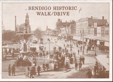
Flyer - Bendigo Historic Walk / Drive
... folded to show map of Bendigo and walking tour options to visit... pamphlet. A3 quarter folded to show map of Bendigo and walking tour ...1988 Bendigo Historic Walk / Drive pamphlet. A3 quarter folded to show map of Bendigo and walking tour options to visit local buildings. Dual print in two colours (orange and brown) includes several images.walking tour, driving tour -
 Bendigo Historical Society Inc.
Map - HUSTLERS LINE OF REEFS - LONGITUDINAL SECTION THROUGH THE SADDLE REEFS
... along portion of Hustler's Line of Reefs, Bendigo. Map shows...MINING hustler's reef maps Hustlers Line of Reefs Bendigo ...Drawing with Longitudinal Section through the Saddle Reefs along portion of Hustler's Line of Reefs, Bendigo. Map shows the depth of the mines, reef numbers and Datum 700 ft above sea level. North and South is also noted on the map. Map signed by H. S, Whitelaw, Underground Survey Office, Bendigo, September 1913. Bulletin No 33, Plate No XXXIV. Bendigo Creek, Ironbark Creek and Long Gully are also noted. Mines are: Fortuna Hustlers, Hustler's Royal Reserve No 2 Main Shaft, Hustler's Royal Reserve No 2 Park Shaft, Royal Hustler's, Imperial Hustler's, Extended Hustler's Freehold, Great Extended Hustler's Tribute (Pups), Old Shaft, Great Extended Hustler's Reef No 2, Great Extended Hustler's Main Shaft, Old Shaft, Hustler's Reef, Hustler's Reef No 1, Comet, K. K., United Hustler's & Redan, Old Shaft and Hustler's Consols. Has Geological Survey of Victoria Crest and underneath is: H. Herman, Director, W. Dickson, Secretary for Mines, The Hon. J Drysdale Brown M L C. Minister of Mines.Geological Survey of Victoria Crestmining, hustler's reef maps, hustlers line of reefs, bendigo creek, royal hustler's, imperial hustler's, extended hustler's freehold, great extended hustler's tribute (pups), great extended hustler's reef no 2, great extended hustler's main shaft, hustler's reef, hustler's reef no 1, united hustler's & redan, old shaft and hustler's consols.h s whitelaw, underground survey office bendigo september 1913 -
 Bendigo Historical Society Inc.
Map - GUIDE MAP OF BENDIGO & EAGLEHAWK, Late 1920's
... GUIDE MAP OF BENDIGO & EAGLEHAWK...Guide Map of Bendigo and Eaglehawk...Map. Guide Map of Bendigo & Eaglehawk. Light brown... COTTAGE Miners Guide Map of Bendigo and Eaglehawk Map. Guide Map ...Map. Guide Map of Bendigo & Eaglehawk. Light brown coloured booklet containing folded map of Bendigo and Eaglehawk. Outer cover is printed in blue and red ink and states - With compliments of J H Curnow & Son, Auctioneers, Real Estate Agents, Farm & Dairy Produce Merchants, Bendigo. Printed by J B Young, Lithographer. Map shows tramways & bus routes. Map shows Agricultural Showgrounds located between Park Street, Water Street, Barnard Street and Bridge Lane. Also shows Acclimitization Reserve located behind The Botanical Gardens at White Hills. Shows the location of Sailors Gully, Peg-Leg Gully, Jobs Gully, California Gully, Long Gully, Ironbark Gully, Golden Gully, Poverty Gully, Sheepshead Gully, Charcoal Gully, Eaglehawk Creek, Bendigo Creek and Back Creek. Contains interesting facts about Bendigo - Area 7,900 acres. Population - 26,000. First Council elected - 1855. Proclaimed a Borough - 1863. Proclaimed a City - 1871. Gold Rush broke out - 1851. For first 10 years gold yield averaged 8,600 ozs. per week . Total gold yield to 1923 - 572 tons valued at 82,000,000 pounds. Deepest mines - Victoria Quartz 4,614 ft., New Chum Railway 4,318 ft. 13 mines over 3.000 ft. deep. 53 mines over 2,000 ft. deep. Sewering of City commenced 1922, all principal buildings now sewered. Map printed by Arnall & Jackson, General Printers, Stationers & Engravers, 476 Collins Street. Map displays advertisement for J H Curnow & Son, Bendigo's leading Auctioneer and Estate Agents, Mitchell & Queen Sts. Bendigo. Map Scale 20 chs. = 1 in.cottage, miners, guide map of bendigo and eaglehawk -
 Bendigo Historical Society Inc.
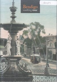
Booklet - Bendigo Walking Tour by Glenn Woodger
... photos of 58 buildings in Bendigo with a map outlining 3 walking... 2003. Includes photos of 58 buildings in Bendigo with a map ...52-page soft cover booklet with colour photo of the fountain at Charing Cross on front and back covers. 'Bendigo Walking Tour' authored by Glenn Woodger, June 2003. Includes photos of 58 buildings in Bendigo with a map outlining 3 walking tours. A narrative is included with most photos. A list of references and acknowledgements is given on back page. bendigo, buildings, walking tour -
 Bendigo Historical Society Inc.
Map - COMET MINE - TRANSVERSE SECTION COMET MINE
... , Underground Survey Office Bendigo September,1913. Map shows depth.... A. Whitdon, Underground Survey Office Bendigo September,1913. Map ...Transverse section of the Comet Mine on the Hustler's Line of Reef Bulletin No 33, Plate No XXV signed by H. A. Whitdon, Underground Survey Office Bendigo September,1913. Map shows depth of the different levels, the type of stone and shaft about 2020 deep. A number of smaller drawings on the side. Reference explaining the different types of stone, etc. Geological Survey of Victoriamining, hustler's line of reefs, transverse section of comet mine bulletin no 33 plate no xxv, lightning hill line of reef -
Bendigo Historical Society Inc.
Book - BLUE GUIDE 1988, 1988
... Blue Guide 1988 - booklet of Bendigo information... plus loose map of Bendigo Book BLUE GUIDE 1988 ...Blue Guide 1988 - booklet of Bendigo information with illustrations and map. Includes emergency contaacts, bus and rail timetables, telephone directory, services listing, Justices of the Peace. Booklet sent 'To the Householder' 56 pages plus loose map of BendigoBlue guide publicationsbendigo, hospital, bendigo, information booklet, blue guide. -
 Bendigo Historical Society Inc.
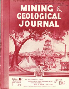
Book - MINING & GEOLOGICAL JOURNAL. VOL.S,NO.6, 1942
... and mining including Bendigo mines, Photographs, Illustrations, Maps...Bendigo Historical Society Inc. Bendigo Historical Society ...Mining & Geological Journal, Vol.2, No.6. March 1942. Published by Department of Mines Victoria, with articles on mines and mining including Bendigo mines, Photographs, Illustrations, Maps & Advertisements. Name on cover A Richardson 29 Harrison St Bendigo.Dept of Mines Victoriagold mines, mining, mining - mines - mining equipment. bendigo mines. -
 Bendigo Historical Society Inc.
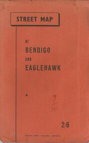
Document - BENDIGO TOURISM BROCHURES COLLECTION: MAP OF BENDIGO AND EAGLEHAWK
... BENDIGO TOURISM BROCHURES COLLECTION: MAP OF BENDIGO AND... Map of Bendigo and Eaglehawk. Four page index of street names... booklet containing fold-out Street Map of Bendigo and Eaglehawk ...Document. Orange covered booklet containing fold-out Street Map of Bendigo and Eaglehawk. Four page index of street names pasted inside back cover. Printed on front cover 2/6, ''Bolton Bros. Printers- Bendigo.document, memo, bendigo tourism brochures -
 Bendigo Historical Society Inc.
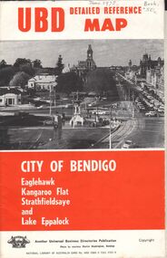
Document - UBD DETAILED REFERENCE MAP - CITY OF BENDIGO
... UBD DETAILED REFERENCE MAP - CITY OF BENDIGO... Reference Map - City of Bendigo Eaglehawk, Kangaroo Flat... Directories Publication UBD Detailed Reference Map - City of Bendigo ...Universal Business Directories Publication UBD Detailed Reference Map - City of Bendigo Eaglehawk, Kangaroo Flat Strathfieldsaye and Lake Eppalock Single page folded map sheet providing three maps: * Bendigo, Eaglehak & Shire of Strathfieldsaye on main sheet * Eppalock & Environs * Kangaroo Flat hand written date June 1975, and 50 cents costUniversal Business Directories Publication -
 Bendigo Historical Society Inc.
Document - MCCOLL, RANKIN AND STANISTREET COLLECTION: GOLDEN CARSHALTON NO LIABILITY, 1949
... /8/1949. Golden Carshalton N\L Map of Bendigo Sandhurst Lease... 16/8/1949. Golden Carshalton N\L Map of Bendigo Sandhurst ...Documents: Gold Mining Lease No. 11257 FOL.36397 Bendigo 16/8/1949. Golden Carshalton N\L Map of Bendigo Sandhurst Lease No 11257 showing the Carshalton Mines Ltd New Main Shaft, Hansel Mundy Shaft.MCCOLL RANKIN AND STANSISTREETorganization, business, gold mining - legal, mccoll rankin and stansistreet. golden carshalton n\l. mundy shaft. -
Bendigo Historical Society Inc.
Map - MAP - THE INFANCY OF BENDIGO - GOLDEN SQUARE IN 1851
... MAP - THE INFANCY OF BENDIGO - GOLDEN SQUARE IN 1851...Map The Infancy of Bendigo & Golden Square 1851...Hand-drawn map of Bendigo - Golden Square in 1851. Map... Inc. History House 11 Mackenzie Street Bendigo goldfields MAP ...Hand-drawn map of Bendigo - Golden Square in 1851. Map shows the chain of waterholes, Golden Gully, hill and bush areas and open treeless flat. Mentioned on the map are places where there were mia mias, stockyards, Gibson & Fenton's butchery & First Store.map, bendigo, goldfields, map the infancy of bendigo & golden square 1851, capt dane, william johnson, mrs kennedy, mrs farrell, ben hall, chris asquith, gibson & fenton's butchery & first store, p odonnell, walter r sandbach, william sandbach, mr frencham, john ross, thos myers, bendigo hut & little stockyard, commissioner horne, j jones, c cohen -
Bendigo Historical Society Inc.
Map - GEOLOGICAL MAP OF BENDIGO GOLD FIELD
... GEOLOGICAL MAP OF BENDIGO GOLD FIELD...Map of Bendigo gold field showing anticlines, synclines...BENDIGO Gold mining geological map Geological Survey ...Map of Bendigo gold field showing anticlines, synclines, shaft, alluvial deposits and contour lines. Map is in two sections. This map forms part of the Geological Survey of Victoria, Structure of Bendigo Goldfield report, No. 47, 1923. H.Herman, late Director of Geological Survey.Geological Survey Victoriabendigo, gold mining, geological map -
Bendigo Historical Society Inc.
Map - DEBORAH MINE - MAP OF LINES OF REEF AND MINES (BENDIGO)
... Two adjoining photocopies of part of map of Bendigo... and Mines (Bendigo). Two adjoining photocopies of part of map ...Two adjoining photocopies of part of map of Bendigo Goldfield showing lines of reef, mines, streets, locations and contour lines. Map is a beige colour with darker lines and letters. Some of the mines have their depths printed beside them. This item is stored in Map drawer 7mine, gold, deborah mine, deborah mine, map of lines of reef and mines (bendigo). -
 Bendigo Military Museum
Book - BOOK, BENDIGO, Brown Prior Anderson, Bendigo The Golden Age Retraced, 1980
... flyleaf & end papers. Map of Bendigo. Inscriptions.... background. Front & back flyleaf & end papers. Map of Bendigo ...Soft, cardboard cover. Black / white print on front, spine & back. Yellow background illustrated with sketches of the Central Deborah Mine with a tram. 63 cut, white pages. Illustrated sketches in black on white background. Front & back flyleaf & end papers. Map of Bendigo. Inscriptions.Handwritten in blue ink on title page: “25.12.80. To Dad. Merry Xmas 1980” Handwritten in blue ink on contents page: “Rail to Bgo opened Oct 21 1962 to P Hill 12 Feb 1884 a period of 22 yrs”book, bendigo, golden age, retraced -
 Bendigo Historical Society Inc.
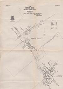
Map - COMET MINE - LONGITUDINAL SECTION COMET MINE
... . Whitelaw, Underground Survey Office Bendigo, September 1913. Map.... Whitelaw, Underground Survey Office Bendigo, September 1913. Map ...Longitudinal section of the Comet Mine on the Hustler's Line of Reef Bulletin No 33, Plate No XXVI signed by H. S. Whitelaw, Underground Survey Office Bendigo, September 1913. Map shows datum lines, depths of levels, approximate boundaries and references to other plans. Note - Plates 4, 8, 13, 20, 26 and 31 form a Longitudinal Section from Fortuna Hustler's to Hustler's Consols Mine. Geological Survey of Victoriamining, parish map, hustler's line of reef, longitudinal section of comet mine bulletin no 33 plate no xxvi, h s whitelaw -
 Bendigo Historical Society Inc.
Map - STRUGNELL COLLECTION: HUSTLER'S LINE OF REEFS, BENDIGO, September 1913
... Map, Hustler's Line of Reefs, Comet Mine, Bendigo... Inc. History House 11 Mackenzie Street Bendigo goldfields MAP ...Map, Hustler's Line of Reefs, Comet Mine, Bendigo Plan.Plate No.XX1V (24). Map, Bulletin No 33 Signed H.A.Whitelaw Underground survey Office Bendigo September 1913 Drawing shows upper and lower levels and appears to show samples of connecting horizontal shafts with their respective mineral contentsUnderground Survey Office, Bendigo.map, bendigo, comet mine -
Bendigo Historical Society Inc.
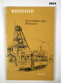
Book - BENDIGO THE GOLDEN AGE RETRACED, 1973
... . Illustration of tram and poppet head on the cover. Map od Bendigo... on the cover. Map od Bendigo printed inside front and back covers. Book ...BHS CollectionBendigo The Golden Age Retraced History of Bendigo 64 pages. Black and white illustrationd. Mallaya Publications. Printed by Brown Prior Anderson Melbourne. Mustard coloured soft cover. Illustration of tram and poppet head on the cover. Map od Bendigo printed inside front and back covers.Jan Neil -
 Bendigo Historical Society Inc.
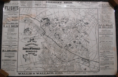
Map - Sands & McDougall Bendigo
... bendigo map...Map of Bendigo and District produced by Sands & McDougall...bendigo map Sands & McDougall Map of Bendigo and District ...Map of Bendigo and District produced by Sands & McDougall. The map is printed in black and white and surrounded by advertsing from bendigo Businesses, including Flight's, B & G Barton, Edwards & Lee, Breheny Bros, Le Roy Cycle Works, John W Faul, Alf E Wallis & Wallace.bendigo map, sands & mcdougall -
 Bendigo Historical Society Inc.
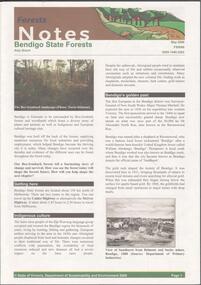
Document - BENDIGO STATE FORESTS - FORESTS NOTES
... forests. Map of Bendigo State forests.... - Activities to enjoy in State forests. Map of Bendigo State forests ...Forests Notes: Bendigo State forests newsletter published May 2006 by the State of Victoria, Department of sustainability and Environment. Getting there - indigenous culture - Bendigo's golden past - Geology and geomorphology - Discover nature treasures - Bendigo State forests - Activities to enjoy in State forests. Map of Bendigo State forests.government, state, department of sustainability -
 Bendigo Historical Society Inc.
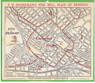
Document - FIRE BELL PLAN OF BENDIGO
... by F.H.Sparkman. A street map of Bendigo split up into a central zone... of Bendigo issued by F.H.Sparkman. A street map of Bendigo split up ...Plan Document. A Fire Bell Plan of Bendigo issued by F.H.Sparkman. A street map of Bendigo split up into a central zone plus four surrounding zones. It is probably the upper part of a calendar with the date section missing (torn off). F.H.Sparkman was a printer and a Mason. Date not shown but probably prior to 1950F.H.Sparkmanessential services, firefighting, fire bell plan of bendigo, fire bell plan, f.h.sparkman -
Bendigo Historical Society Inc.
Map - CAMPBELL COLLECTION: PARISH MAPS
... Nineteen Parish maps of Bendigo area in a plastic bag...BHS Collection Nineteen Parish maps of Bendigo area ...BHS CollectionNineteen Parish maps of Bendigo area in a plastic bag. Mostly original maps. Copies or originals of all maps are available to access in the Map Cupboard. Not catalogued separately. Maps come from Don Stewart, 10 Avery's Rd. Eaglehawk. Don now deceased. He worked in a Government job in bendigo. -
Bendigo Historical Society Inc.
Map - JOHN WILLIAMS COLLECTION: PHOTO-MAP OF BENDIGO, 2007
... JOHN WILLIAMS COLLECTION: PHOTO-MAP OF BENDIGO...Map, Photo-map of Bendigo,Australian Government Department... Inc. History House 11 Mackenzie Street Bendigo goldfields MAP ...Map, Photo-map of Bendigo,Australian Government Department of Defence,prepared and published by the Defence Imagery and Geospatial Organisation 2007.Copyright Commonwealth of Australia 2007.Australia Photomap 1:15 000. Edition 2-DIGO. WGS84.Grid 1000 metre UTM Zone 55. (number 407 in map cupboard 1)Defence Imagery & Geospatial Organisationmap, bendigo, city streets -
 Ballarat Tramway Museum
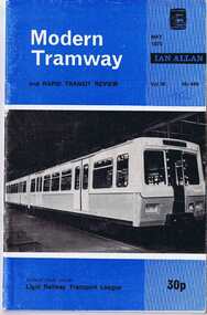
Magazine, John Price and David Menzies, "A Museum Trilogy", 1975
... of 3 part article, Bendigo, with map of system, by W. J. Wyse 4... article, Bendigo, with map of system, by W. J. Wyse 4/62 ....1 - Modern Tramway & Rapid Transit Review - May 1975 issue, Vol38 No. 449 p157. - from the Part One of Three part article Ballarat Tramway System history, with Map of System complied by W.J.Wyse 3/62 from sketch by A.T.Marshall with various photos of Bendigo and Ballarat. Part 1 of "A Museum Trilogy", written by John Price and David Menzies. .2 - Modern Tramway & Rapid Transit Review - August 1975 issue, Vol. 38, No 451, p267, part 3 of 3 part article, Bendigo, with map of system, by W. J. Wyse 4/62, completed from sketch by A.T. Marshall, along with various photos. Part 2 of "A Museum Trilogy", written by John Price and David Menzies. Record revised and images of cover, index and article added.Both issues with biro "75c"trams, tramways, trams, rapid transit, ballarat tramways, bendigo -
 Bendigo Historical Society Inc.
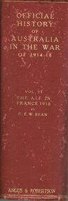
Book - OFFICIAL HISTORY OF AUSTRALIA IN THE WAR OF 1914 TO 1918
... , inside cover signed A.E./ Emmerson , 74 Sternberg St Bendigo... Bendigo , 530 illustrations and maps , Book OFFICIAL HISTORY ...Official History of Australia in the war of 1914-1918 Vol VI The AIF in France 1918 - The Armistice by C.E.W. Bean , published by Angus & Robertson 89 Castlereagh St Sydney 1942 , faded maroon hard bound covered book with gold lettering , inside cover signed A.E./ Emmerson , 74 Sternberg St Bendigo , 530 illustrations and maps ,C.E.W. Beanbooks, military, the aif in france 1918 - the armistice / c.e.w. bean -
 Bendigo Historical Society Inc.
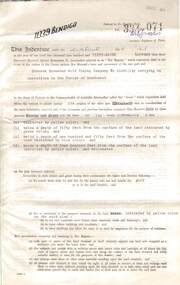
Document - MCCOLL, RANKIN AND STANISTREET COLLECTION: DEBORAH EXTENDED GOLD MINING COMPANY N/L GOLD MINING LEASE, 18 April 1957
... pages with map. Map adjoins Bendigo Cemetery. Lease between... 1957, 4 pages with map. Map adjoins Bendigo Cemetery. Lease ...Document Deborah Extended Gold Mining Company N/L document - gold mining lease document, Vol 334 071, dated 18 April 1957, 4 pages with map. Map adjoins Bendigo Cemetery. Lease between Deborah Extended Gold Mining Company N/L and the State of Victoria. No. 11339, Vol 334 Fol 071.organization, mining, gold mining lease, deborah extended gold mine, gold mining lease -
Bendigo Historical Society Inc.
Map - MAP WHITE HILL TO HUNTLY
... Map of Bendigo creek and adjacent leads - White Hills... BENDIGO Mining Map of Bendigo creek and adjacent leads - White ...Map of Bendigo creek and adjacent leads - White Hills to Huntly replotted from old 4 chain to 1 inch survey of 1860 by G. W. Hart - Surveyor. Base of roads and streets taken from D.L.S. 1 . 10000 base maps. Legend: battery site, puddling mill site, dam bank site, cutting altering course of creek, lead boundaries.bendigo, mining -
 Bendigo Military Museum
Photograph - Royal Australian Survey Corps - Map Production Processes, c1990
... Survey Corps phases of map production at the School of Military..., the Army Survey Regiment, Bendigo, and the Army Map Depot, Bandiana..., Bendigo, and the Army Map Depot, Bandiana circa 1990. Colour ...This is a collection of 20 photographs of Royal Australian Survey Corps phases of map production at the School of Military Survey, Bonegilla, the Army Survey Regiment, Bendigo, and the Army Map Depot, Bandiana circa 1990. Colour photos are on 35mm slide film and were scanned at 96 dpi. They are part of the Army Survey Regiment’s Collection. Photo .1P was probably taken on a survey station overlooking Lake Hume near Albury-Wodonga. The field party occupying the survey station was likely from a Map Control Survey course conducted by the School of Military Survey, Bonegilla. This survey station was part of a geodetic network used in field survey training and RASvy’s Lake Hume Test Range. Photos .3P to .16P were taken at the Army Survey Regiment, Bendigo and photos .17P & .18P were taken at the Army Map Depot, Bandiana. Photo .19P depicts a map of RASvy’s ARA units before the disbandment of 5th Field Survey Squadron, Perth and 2nd Field Survey Squadron, Sydney in 1990. This is a collection of 20 photographs of map production processes taken at the School of Military Survey, Bonegilla, the Army Survey Regiment, Bendigo, and the Army Map Depot, Bandiana circa 1990. Colour photos are on 35mm slide film and were scanned at 96 dpi. They are part of the Army Survey Regiment’s Collection. Photo .2P is printed on photographic and scanned at 300 dpi. .1) – Photo, colour, c1980s. Geodetic Surveying: AN/PRR-14 Geoceiver antenna on hill surrounding Lake Hume. Series 3 Land Rover, field party tent and survey station beacon in background. .2) – Photo, black & white, c1980s. Geodetic Surveying: AN/PRR-14 Geoceiver antennas set up at the School of Military Survey, Bonegilla, Victoria. .3) – Photo, colour, c1990. Aerotriangulation: Wild PUG4 point transfer device, SSGT Bruce Hammond. .4) – Photo, colour, c1990. Aerotriangulation: Zeiss (Jena) Stecometer, SSGT Bruce Hammond. .5) – Photo, colour, c1990. Aerotriangulation: computer tape maintenance, SSGT Noel McNamara. .6) – Photo, colour, c1990. AUTOMAP 2: computer tape maintenance, SPR Nadine (Paul) Read. .7) - Photo, colour, c1990s. AUTOMAP 2: Optronics 4040 scanning/film output in Lithographic Squadron, SGT Sherri (Dally) Burke. .8) - Photo, colour, c1990s. AUTOMAP 2: Benson verification plotter output, SPR Nadine (Paul) Read. .9) – Photo, colour, c1990. Aerotriangulation: data management, SGT Neil ‘Ned’ Kelly. .10) & .11) - Photo, colour, c1990s. AUTOMAP 2: Wild B8 Aviograph stereoplotter Feature Extraction, unidentified technician. .12) - Photo, colour, c1990s. AUTOMAP 2: Graphic Edit Workstation, SPR Nadine (Paul) Read. .13) - Photo, colour, c1990s. AUTOMAP 2: Graphic Edit Workstation, SPR Dawn Hoadley. .14) & .15) - Photo, colour, c1990s. AUTOMAP 2: Graphic Edit Workstation, unidentified technician. .16) – Photo, colour, c1990s. Heidelberg Speedmaster 102 computer-controlled five colour lithographic offset printing press. .17) & .18) – Photo, colour, c1990s. Army Map Depot, unidentified storeman, Bandiana. .19) – Photo, colour, c1990. RASvy ARA Unit Locations before disbandment of field units in Perth and Sydney. .20) – Photo, colour, c1990. Set of overlapping aerial photography..1P, .3P to .20P - Some equipment is identified on the frame of the 35mm slides.royal australian survey corps, rasvy, army survey regiment, army svy regt, fortuna, asr, school of military survey, army map depot -
 Bendigo Historical Society Inc.
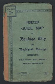
Map - INDEXED GUIDE MAP OF BENDIGO CITY & EAGLEHAWK BOROUGH, Early to mid 1920's
... INDEXED GUIDE MAP OF BENDIGO CITY & EAGLEHAWK BOROUGH...Indexed Guide Map of Bendigo City and Eaglehawk Borough...Map. Indexed Guide Map of Bendigo City & Eaglehawk Borough... Inc. History House 11 Mackenzie Street Bendigo goldfields MAP ...Map. Indexed Guide Map of Bendigo City & Eaglehawk Borough. Folded map contained within blue booklet. Booklet is light blue printed with dark blue ink. Copyright Bolton Bros. Pty. Ltd. Bendigo. Printed on front. Map shows the location of Sailors Gully, Peg Leg Gully, California Gully, Long Gully, Eaglehawk Creek, Bendigo Creek, Ironbark Creek. Shows location of Showgrounds between Park St, Baxter Street, Barnard St and Bridge Lane. Shows location of Golden Square Railway Station between Panton St and Allingham St. Shows what is now known as Creek St. Nth & Sth as Clark St Nth & Sth. Also shows Tramway Terminus along Carpenter St and Golden Square Tram Terminus on High St, Golden Square. Map has a street index and an index for Public Offices, Parks and Reserves.map, bendigo, township, indexed guide map of bendigo city and eaglehawk borough -
 Bendigo Historical Society Inc.
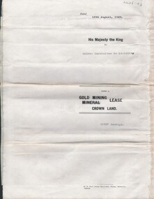
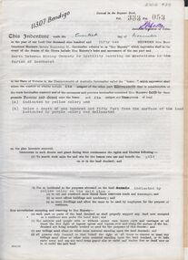
Document - MCCOLL, RANKIN AND STANISTREET COLLECTION: INDENTURE NORTH DEBORAH MINING COMPANY, 20th November, 1952
... Bendigo' plus map. Indenture document between Queen Elizabeth 11... ' Gold Mining Lease Crown land Number 11307 Bendigo' plus map ...6 page document ' Gold Mining Lease Crown land Number 11307 Bendigo' plus map. Indenture document between Queen Elizabeth 11 and North Deborah Mining Company No Liability, Parish of Sandhurst, dated 20th November, 1952 re Vol 333, Folio 053. Land indicated by yellow on map and below ' a depth of one hundred and fifty feet from the surface of the land indicated by purple colour and delineated on the plan' Document signed by J. Stanistreet, Manager, North Deborah Mining Company No Liability. Map, fixed to document, heading ' Mining District of Bendigo, No. 11307, County of Bendigo, Parish of Sandhurst, Total area 13 acres 2 roods, 11 perches. Map shows large dam on Crown land, transmission line excised 150 ft., written on purple area. Underneath map ' provided that the dam indicated on the said plan is hereby reserved'.bendigo, mining, north deborah mining company