Showing 622 items
matching black mountain
-
 Marysville & District Historical Society
Ephemera (Item) - Advertising brochure, Marysville Ski Centre, Unknown
An advertising brochure for Marysville Ski Centre in Victoria.An advertising brochure for Marysville Ski Centre in Victoria. Marysville Ski Centre is a family-owned business, which has been operated by Nat and Beryl Morandi since 1981. The business started from very humble beginnings hiring toboggans at Lake Mountain initially from the back of a Bedford Van, and then upgraded to a rickety old shed with the addition of ski equipment for hire. In 1983, Marysville Ski Centre commenced business in its current position in Marysville. Then this building was destroyed, along with most of the buildings in Marysville, during the 2009 Black Saturday bushfires. Currently, the business operates from their new custom-designed ski hire which has been built to cater for the different needs of the hire.marysville, victoria, marysville ski centre, photograph, nat morandi, beryl morandi, 2009 black saturday bushfires -
 Marysville & District Historical Society
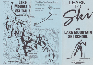
Ephemera (Item) - Advertising brochure, Learn To Ski With Lake Mountain Ski School, 1989
An advertising brochure for Lake Mountain Ski School in Victoria.An advertising brochure for Lake Mountain Ski School in Victoria. Marysville Ski Centre is a family-owned business, which has been operated by Nat and Beryl Morandi since 1981. The business started from very humble beginnings hiring toboggans at Lake Mountain initially from the back of a Bedford Van, and then upgraded to a rickety old shed with the addition of ski equipment for hire. In 1983, Marysville Ski Centre commenced business in its current position in Marysville. Then this building was destroyed, along with most of the buildings in Marysville, during the 2009 Black Saturday bushfires. Currently, the business operates from their new custom-designed ski hire which has been built to cater for the different needs of the hire.marysville, victoria, marysville ski centre, photograph, nat morandi, beryl morandi, 2009 black saturday bushfires -
 Marysville & District Historical Society
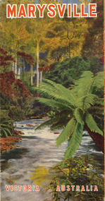
Ephemera (Item) - Tourist brochure, Victorian Railways, Marysville Victoria Australia, 01-1941
A tourist information brochure that was issued by the Publicity and Tourist Services of Victorian Railways, in January, 1941, to promote Marysville and the surrounding district.A tourist information brochure that was issued by the Publicity and Tourist Services of Victorian Railways, in January, 1941, to promote Marysville and the surrounding district.marysville, victoria, cumberland valley, messmate, buxton, taggerty river, acheron way, black's spur, cement creek, keppel falls, steavenson falls, cumberland falls, narbethong, st fillan, taggerty valley, wade's lookout, mount gordon, nicholls lookout, lake mountain, victorian government tourist bureau, victorian railways -
 Marysville & District Historical Society
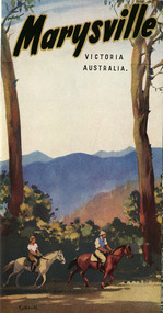
Ephemera (Item) - Tourist brochure, Victorian Railways, Marysville Victoria Australia, 01-1941
A tourist information brochure that was issued by The Victorian Railways Commissioners, in conjunction with The Marysville and District Tourist and Progress Association in 1948, to promote Marysville and the surrounding district.A tourist information brochure that was issued by The Victorian Railways Commissioners, in conjunction with The Marysville and District Tourist and Progress Association in 1948, to promote Marysville and the surrounding district.marysville, victoria, cumberland valley, messmate, buxton, taggerty river, acheron way, black's spur, cement creek, keppel falls, steavenson falls, cumberland falls, narbethong, st fillan, taggerty valley, wade's lookout, mount gordon, nicholls lookout, lake mountain, victorian government tourist bureau, victorian railways, marysville and district tourist and progress association -
 Marysville & District Historical Society
Ephemera (Item) - Tourist brochure, Victorian Railways, Marysville Victoria Australia, 01-1941
A tourist information brochure that was issued by The Victorian Railways Commissioners, in conjunction with The Marysville and District Tourist and Progress Association in 1948, to promote Marysville and the surrounding district.A tourist information brochure that was issued by The Victorian Railways Commissioners, in conjunction with The Marysville and District Tourist and Progress Association in 1948, to promote Marysville and the surrounding district.marysville, victoria, cumberland valley, messmate, buxton, taggerty river, acheron way, black's spur, cement creek, keppel falls, steavenson falls, cumberland falls, narbethong, st fillan, taggerty valley, wade's lookout, mount gordon, nicholls lookout, lake mountain, victorian government tourist bureau, victorian railways, marysville and district tourist and progress association -
 Glenelg Shire Council Cultural Collection
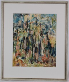
Painting, Enid Denton, Rain Forest, 1972
UnknownAbstract scene of a rainforest. Foreground depicts a stand of trees. There are several mountains in the background, set against a blue sky with rays of sun falling on a central mountain. Predominant colours for trees are green, yellow, brown and black. Mounted on cream matt in pale green frame, with glass glazing.Front: Enid Denton (lower right) (brown paint) Back: Rain Forest $600.00 Enid Denton, Smith Avenue, Croydon 3136cema, portland artists society -
 Glenelg Shire Council Cultural Collection
Painting, Enid Denton, Flinders Ranges, 1963
CEMA Art Collection Winner of 1963 Portland Art Society Art Prize for category Watercolour. Included in the 1999 "Salvage" exhibition at CEMA Arts Centre.The painting depicts mountain ranges from an elevated position looking down across the mountains. The mountains in the foreground are predominantly shades of green, yellow and brown. The mountains in the background are various shades of blue and extend into a pale blue sky. The work has a grey painted frame with a white cardboard mount and glass.Front: E Denton (lower right, black paint) Back: ENID DENTON "FLINDERS RANGES" (1963) Watercolour (typed label) 1963 (yellow sticker) -
 Greensborough Historical Society
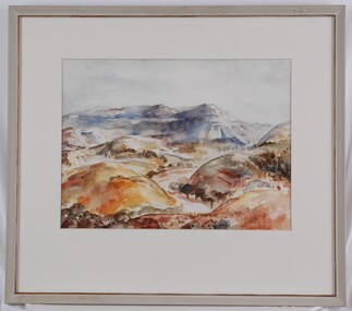
Document - Leaflet, Introducing the Monty Hub Project, 2021 c
Proposal to develop the site with existing buildings at 1-3 Mountain View Road Montmorency as a community hub. The buildings are a former church and kindergarten designed by Alistair Knox. 2 p., printed in black both sides on off white paper, plan, photographmontmorency hub, monty hub project -
 Montmorency/Eltham RSL Sub Branch
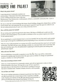
Pamphlet - German Propaganda Leaflet El Alamein 1942, El Alamein German Propaganda Leaflet, World War Two 1942
Leaflet dropped from German/Italian aircraft on to Australian troops defending El Alamein during 1942. These propagander leaflets were designed to lower moral of defending troops, but were generally unsuccessful. This item relates to the history of the defence of El Alamein by Australian Forces in the Middle East 1942, and the bombing of Darwin by the Japanese in 1942.Printed paper, colour black white. top of pamphlet depicts a stylized platypus and boomerang - the 9th Division's Formation Sign, with text below. Printed on pamphlet "Diggers! / you are defending / Alamein Box! / What about / Port Darwin?" world war two, el alamein, propaganda, leaflet, plane drop, port darwin, diggers, platypus, boomerang -
 Montmorency/Eltham RSL Sub Branch
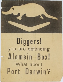
Souvenir - Framed Embroided Handkerchief, WW2 embroidered handkerchief, Estimated date 1941
Framed World War Two souvenir embroidered silk handkerchief. A soldier aiming his rifle, done in black, is in the bottom left hand corner and an inscription with the Australian flag in the top right hand corner is done in black and red. The background is yellow.Souvenir to Australia. Army in Syria and Lebanon. AIF 1941.world war two, australia, army, aif, 1941, souvenir, silk, handkerchief, embriodery, syria, lebanon -
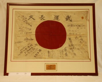 Montmorency/Eltham RSL Sub Branch
Flag - Framed Japanese Flag, WW2 Japanese Flag, Estimated date 1942
Framed Japanese flag. Black Japanese writing and a red disc on a white background.Japanese writing. Translates to 'Long Live our Victories".world war two, japan, battalion, 1942, new, guinea, flag, japanese, wewak, 2 4th -
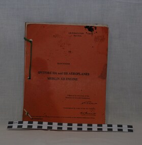 Montmorency/Eltham RSL Sub Branch
Manual - Spitfire 11A and 11B Aeroplanes Merlin XII Engine Pilots Instruction Manual, Spitfire Pilots Instruction Manual, Estimated 1940-1945
The cover of the manual has black lettering on an orange backgroundAir Publication 1565B Pilots Notes Spitfire 11A and 11B Aeroplanes MerlinXII Engine Prepared by Direction of the Minister of Aircraft Production.manual, pilots instruction manual, aeroplanes, spitfire 11a, spitfire 11b, merlin, merlin xii engine, training manual, minister of aircraft -
 Montmorency/Eltham RSL Sub Branch
Headwear - Hat, Khaki, Fur Felt, WW2 (Womens), 1943
Women's service hat worn by Corporal Kathleen Phyllis Gill from Toorak Hill, Casterton. Army No. VF345716 Unit LHQ (Mil. Sec)Women's khaki felt service hat with brim. Tan band around the hat. Australian Military Forces badge at the center front on the band. Red over black unit patch attached to the right side of the band. Tag attached inside the hat stating - V.306 1943 Made in Australia. Size 6 1/2 kathleen gill, women's service hat, felt -
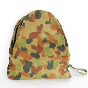 Montmorency/Eltham RSL Sub Branch
Accessory - Backpack, January 1995
Standard Backpack with camouflage pattern with one zip at top of backpack, two black pastic clips on back sideInternal front side 8465-66-139-4068, SOS, JAN 95backpack, standard issue, january, camouflage -
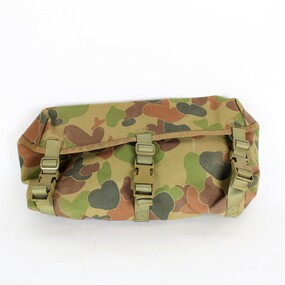 Montmorency/Eltham RSL Sub Branch
Accessory - Satchel, January 1995
Satchel with camouflage pattern, three plastic lock-in clips on front, three black clips on back and one toggle in front. Internal inscription reads, 8465-66-139-4069, SOS, JAN 95sachtel, camouflage, january, 1995 -
 Montmorency/Eltham RSL Sub Branch
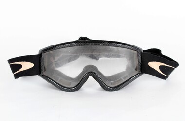
Accessory - Goggles, Oakley
Worn by Swinfield in IraqWorm by Swinfield in IraqOakley clear plastic eye protective goggles. Black and white adjustable elastic strap. Black plastic frame. Face protective foam inner lining. Green fabric covered air slots across the top and bottom of the goggles.Oakley label on the front top frame. White flattened circle with black inner flattened circle on each side front elastic strap. Oakley Logo.iraq, goggles, australian military -
 Montmorency/Eltham RSL Sub Branch
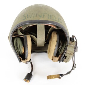
Headwear - Helmet, vehicle, intercom
Worn by Swinfield in IraqWorn by Swinfield in IraqBlack edge trimmed green fibreglass Army vehicle intercom helmet. Adjustable head straps inside helmet, Adjustment strap for right earphone located on ouside of right ear. Earphones mounted inside helmet at each ear side. Voice microphone located at mounting on outside of the left ear connected by black cable to mounting on outside of left ear. Cable connection with clip for helemt connection to vehicle located at outside of left ear. Switch located on mounting on outside of left ear. Plastic mounting box located on ouside of the left ear. Brown leather sweat band on helmet straps on inside front of the helmet. Male and female connections on end of vehicle connection point.Swinfield marked on outside front of helmet. 34B marked on outside of helmet at rear. Roamwell Corp. with number SA-1552,6 marked on plastic mounting on outside of right ear. Front and back markings on microphone. M138/6 marked on back of microphone. ID label on connection point end of vehicle connection cable. -
 Montmorency/Eltham RSL Sub Branch
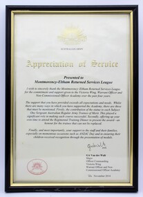
Certificate - Framed 'Appreciation Of Service' Certificate
Appreciation of Service received from Montmorency-Eltham Returned Services LeagueCertificate given to Montmorency-Eltham Returned Services League for commitment and support given to the Australian Army's Victoria Wing, Warrant Officer and Non-Commissioned Officer Academy.Cream paper with gold and black writing with Australian army emblem at the top and Chief of Army stamped in red in bottom left hand corner. It is signed by GA Van der Walt Major Officer Commanding Victoria Wing Warrant Officer and Non-Commissioned Officer Academy. Dated 24 November 2014ga van der walt -
 Montmorency/Eltham RSL Sub Branch
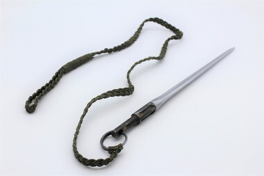
Weapon - Bayonet, SKS rifle spike with woven cord lanyard, Mid to late 20th century
Used by various oversea armed forces. Such as Chinese, Russan, Vietnamese.15 inch (30 cm) three sided fluted steel alloy pointed spike SKS rifle bayonet two colour (Aluminium and black mounting end). Missing the mounting fixure to attach the bayonet to the rifle. Dark green double woven cord Woven cord length (83 cm) attached by split ring. Woven loop at end of cord.sks, rifle, bayonet, lanyard -
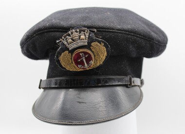 Montmorency/Eltham RSL Sub Branch
Uniform - Merchant Navy Cap
This merchant navy officer's cap has a black woollen felt hat band, black woollen felt fixed top cap and a black patent leather peak. Along the top of the peak there is a black patent strap. At the left hand of the peaked cap is a non-standard black plastic button and on the right side is a standard black cloth button. Above the peak there is a black wool badge of an Officer of the Merchant Navy. This insignia has a central, oval reserve of red velvet edged with gold metal coil with base metal anchor at the centre. The oval is surrounded by oak leaves of gold purl with stems of applied gold coil, and surrounded by a stamped base metal crown. The badge is backed with a wool blend fabric and attached to the top cat by brown cotton. Along the base of the hat band there is a bias hem. Inside the cap, the hat band is lined with hessian. Crimson silk is fixed to the top cap and hand stitched to the hessian as a lining to the cap.British merchant navy officer's cap insignia.merchant navy cap, british merchant navy -
 Montmorency/Eltham RSL Sub Branch
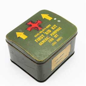
Functional object - Empty First Aid Kit Tin
Square metal tin green in colour with yellow writing and red cross printed on itFirst Aid Kit General purpose for MT in yellow writing with red cross above, black dagger drawn on back of tin. Inside lid schedule of contents, including Serial No, description and unit of Issue, quantityempty first aid kit tin container -
 Montmorency/Eltham RSL Sub Branch
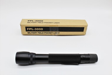
Tool - FPL-3000 Military Field Pocket Light
Small rectangular cardboard box containg a black cylindrical metal and rubber flashlight or torch. The outside of the cardboarch container has black ink markings for identification and manufacture. A white printed ID label containing a barcode is attached to the bottom of the box. The pocket light has a metal attachment clip on its side and a rubber covered on/off switch on the bottom of the light. The body of the light has a knurled section for grip. The lens top section of the field pocket light unscrews of the body to enable the top of the pocket light to be unscrewed to enable battery insertion.FPL-3000 Military Pocket Light Made in Australia NSN no: 6230 66 139 1304 Ocean Graphic Pty. Ltd. Melbourne, Victoria, AUSTRALIA. *6230661391304023* FPL-3000 Black/Green Filter The field pocket light has the NSN marking 6230-66-139-1304 with the Department of Defence arrow marking at the side of the top of the flashlight.fpl-3000, military, field pocket light, australian military -
 Montmorency/Eltham RSL Sub Branch
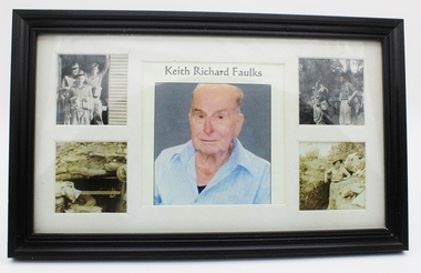
Photograph - Photographs of Keith Richard Faulks
Black and white photos taken in KoreaBlack plastic picture frame with glass front rectangular shape. Cardboard stand attached to backName Keith Richard Faulks in centre with photo of same person. Two photos either side of photo of soldiers and scenes at war surroundings -
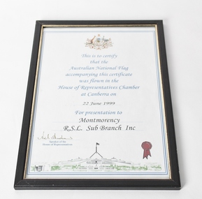 Montmorency/Eltham RSL Sub Branch
Certificate - Framed Certificate - National Flag flown in the House of Representatives Chamber in Canberra, 22June 1999, for presentation to Montmorency R.S.L
This certificate was presented to Montmorency R.S.L Sub Branch Inc with the Australian National Flag by the Speaker of the House of Representatives Neil Andrew on 22nd June 1999Black wood frame with gold inner trim with glassCertificate reads This is to certify that the Australian National Flag accompanying this certificate was flown in the House of Representatives Chamber at Canberra on 22 June 1999 for presentation to Montmorency R.S.L. Sub Branch Inc signed by Speaker of the House of Representatives Back of frame GOV 22/6/99certificate, house of representatives, canberra, australian, flag, coat of arms -
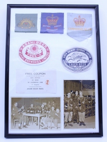 Montmorency/Eltham RSL Sub Branch
Memorabilia - Frame Photos and badges of Keith Richard Faulks
Black plastic frame with 3 badges 2 beer labels 1 Beer coupon and two photos of soldiers drinking beerMaterial badge of Australian Military Forces, Material badge of British Forces Commonwealth, Material badge with crown and commonwealth. Paper label from Asahi Beer and Kirin Brewery Company Lager Beer. Paper coupon from Asahi Beer Hall. 2 photos of soldiers with beer -
 Montmorency/Eltham RSL Sub Branch
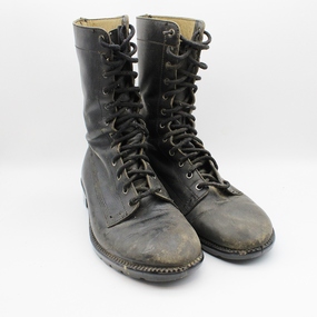
Uniform - Boots, Leather, General Purpose, Vietnam War Era
Worn by Paul Gregory Service No 3795363 Vietnam 1969-1970, Forward Scout, 12 PL. D. Company 6 RAR Vietnam 1970Paul Gregory is a member of the Sub-Branch who served in Vietnam.Black GP Boots with Leather Upper and Synthetic Sole. MH 12 RB Tvietnam, boots, 6 rar -
 Montmorency/Eltham RSL Sub Branch
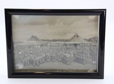
Photograph - Frame Photo of Band of 3 RAR Victoria
Black plastic frame with glass front and photo of Brass BandOnly marking is on back of photo saying Keith Faulks. Korea -
 Montmorency/Eltham RSL Sub Branch
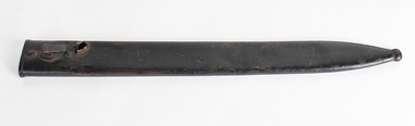
Weapon - Scabbard for German Bayonet, WWI Scabbard
WW1 German steel scabbard for the 1898 German Bayonet. Painted blackNo inscriptions -
 Montmorency/Eltham RSL Sub Branch
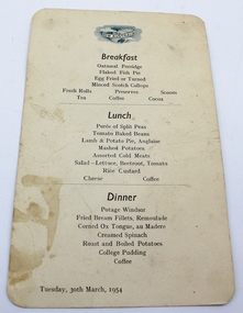
Ephemera - Menu from S.S. New Australia
It was used on S S New Australia when our soldier Keith Richard Foulkes was returning back to Korea in 1954He was returning to service for the second timeCream coloured cardboard sheet with black writing and blue emblem with S S New Australia on globe of the world at the top of page. It has S S New Australia at top of sheet across a globe of the world with Australia at the front. Then there is a Breakfast menu then Lunch and then the Dinner menu at the bottom of the page it is dated Tuesday, 30th March 1954