Showing 772 items matching "breakwater"
-
 Glenelg Shire Council Cultural Collection
Plan - Plans / Line drawings - Port of Portland Authority, Portland Harbour Trust Commissioners Fishermen's breakwater, Victoria, 05/03/1974
PORT OF PORTLAND AUTHORITYFront: '3' black texta, top right corner -
Glenelg Shire Council Cultural Collection
Photograph - Photograph - Main Breakwater construction, Portland, n.d
Port Of Portland Authority ArchivesFront: Wharf 4- biro Back: Wharf 4 -Biroport of portland archives, main breakwater, harbour construction, development, battery point -
Glenelg Shire Council Cultural Collection
Postcard, n.d
Black and white photo postcard, 'Rose' series. View of railway pier at Portland, from beach. Fisherman's Breakwater at rearFront: 'THE ROSE SERIES, P.1094' COPYRIGHT' 'THE PIER, PORTLAND VIC' - bottom border printed Back: Maker's details, logo. Handwritten message -
Glenelg Shire Council Cultural Collection
Photograph - Photograph - harbour dredging, n.d
Port of Portland Authority Archivesport of portland archives, portland harbour, dredging -
Glenelg Shire Council Cultural Collection
Photograph - Photograph - Portland Harbour, n.d
Port of Portland Authority Archivesport of portland archives, portland harbour, railway pier, fishermans breakwater, ocean pier -
Glenelg Shire Council Cultural Collection
Photograph - Photograph - Main Breakwater construction, Portland, n.d
Port of Portland Authority ArchivesFront: 14/1/58- pencil Back: 14/1/58 - Pencilport of portland archives, main breakwater construction, harbour development, aerial photography -
Glenelg Shire Council Cultural Collection
Photograph - Photograph - Main Breakwater construction, Portland, n.d
Port of Portland Authority Achivesport of portland archives, main breakwater, harbour construction, development -
Glenelg Shire Council Cultural Collection
Photograph - Photograph - Main Breakwater Construction, n.d
Port Of Portland Authority Archivesport of portland archives, portland harbour, fawthrop lagoon, aerial photo, main breakwater construction -
Glenelg Shire Council Cultural Collection
Photograph - Photograph - Main Breakwater construction, Portland, 1957
Port of Portland Authority ArchivesBack: Purple H&C stamp top right Remains of B'water after sou'west gale 21 June 1957 - pencilport of portland archives, main breakwater, construction, portland harbour, storm, storm damage -
Glenelg Shire Council Cultural Collection
Photograph - Photograph - Main Breakwater construction, Portland, 1953
Port of Portland Authority ArchivesBack: 1953 - black penport of portland archives, main breakwater, construction, harbour development, euclid truck -
Glenelg Shire Council Cultural Collection
Photograph - Photograph - Lee Breakwater, Portland, n.d
Port of Portland Authority Archivesport of portland archives, lee breakwater, construction, concrete -
Glenelg Shire Council Cultural Collection
Photograph - Photograph - Lee Breakwater, Portland, n.d
Port of Portland Authority Archivesport of portland archives, lee breakwater -
Glenelg Shire Council Cultural Collection
Photograph - Photograph - Model Breakwater, n.d
Port of Portland Authority Archivesport of portland archives, model breakwater -
Glenelg Shire Council Cultural Collection
Photograph - Photograph - Model Breakwater, Model Parapet Wall, n.d
Port of Portland Authority ArchivesFront: Back- 92e, bottom frame, pencilport of portland archives -
Glenelg Shire Council Cultural Collection
Photograph - Photograph - Dredging Trawler Wharf, n.d
Port of Portland Authority Archivesport of portland archives, trawler wharf -
Glenelg Shire Council Cultural Collection
Photograph - Photograph - Main Breakwater Construction, n.d
Port of Portland Authority Archivesport of portland archives, reclamation land, breakwater construction, battery point -
Glenelg Shire Council Cultural Collection
Photograph - Photograph - Main Breakwater construction, Portland, n.d
Port of Portland Authority Archivesport of portland archives, main breakwater, portland, harbour, construction -
Port Melbourne Historical & Preservation Society
Photograph - Breakwater between Station and Princes Piers, Douglas Smallpage, 1970s
The catwalk shown in these photographs was removed after a storm severely damaged it (1970s)Five black and white photographs of the breakwater between Station and Princes Piers and the catwalk to service the outer lead light, 1970sbuilt environment, piers and wharves, beacons -
 Sunbury Family History and Heritage Society Inc.
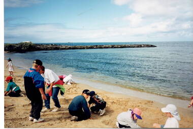
Photograph, Beach excursion, c Early 1996
One of the activities the children enjoyed at their Williamstown Beach excursion was a snd castle competition, which they are busy constructing.A non-digital photograph of a group of children at a beach by the water's edge and digging in the sand. A rocky breakwater is across the middle distance.school excursions, bulla primary schooil, williamstown beach, sand castles -
 Flagstaff Hill Maritime Museum and Village
Document - Navigation Chart, Admiralty Office, Lady Bay and Warrnambool Harbour, 03/04/1871
This Chart titled “Lady Bay and Warrnambool Harbour” was surveyed by Nav. Lieut. H.J. Stanley, of Britain's Royal Navy, in 1870 and printed in April 1871. The chart was made before the Warrnambool Breakwater was built (construction had begun in 1874 and was completed in 1890). The chart includes Directions for entering Lady Bay, Warrnambool Harbour. These are "Vessels entering Warrnambool Harbour must bring the Red Light in sight and steer in with it in line with the upper white Light bearing North, until the Green Light on the Jetty is opened, when steer towards it and anchor. The best anchorage is in 2 ¼ fms [fathoms)] of water, about a cable from ledge off Breakwater rock. Or where convenient, according to draught of water, only endeavouring to anchor as close as possible to Breakwater rock. It is not safe to enter or leave the Harbour in south westerly or Southerly gales.” This chart is significant for its strong connection to the maritime history of Warrnambool Harbour and Lady Bay, and eventually to the Warrnambool Breakwater. The Warrnambool Breakwater is registered as a place of significance on the Victorian Heritage Database (VHR H2024). A copy of the same chart was used to plan several submissions for future changes to the jetty and breakwater. The chart is a historical record of structures existing in 1870; the Warrnambool Jetties, Lady Bay, the leading lights (lighthouses), streets, roads, bridges and many buildings. It also shows the lay of the land and seabed.Canvas chart of Australia, South Coast, Victoria Title: Lady Bay and Warrnambool Harbour Surveyed by Nav. Lieut. H.J. Stanley, R.N., 1870. Magnet Variation, 1870 Published April 3, 1871, by the Admiralty, London. Directions for vessels entering Warrnambool Harbour are printed on the chart. The chart has a lacquer or seal over it.Top of chart has logo "HYDROGRAPHER OFFICE" "Price Eighteen Pence". "Engraved by Edward Weller" Along bottom of Chart: “London… Published at the Admiralty, 3rd April 1871, under the Superintendence of Rear Admiral G.H. Richards, F.R.S. Hydrographer, Corrections July 71” Bottom of chart “Australia South Coast Victoria Lady Bay and Warrnambool Harbour. 2494”flagstaff hill, warrnambool, chart of lady bay warrnambool 1870, warrnambool harbour, cartography, navigation, warrnambool breakwater, 1871, australia – south coast / victoria, lady bay, 1870, nav. lieut. h.j. stanley, r.n, directions for entering warrnambool harbour, hydrographer office, rear admiral g.h. richards, edward weller, port of warrnambool, flagstaff hill maritime museum & village, maritime museum, maritime village, shipwreck coast, map, chart, navigation chart, admiralty chart, breakwater, jetty, pier, vhr h2024 -
 Flagstaff Hill Maritime Museum and Village
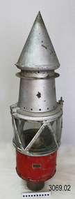
Functional object - Marine Navigation Light, Early 20th century
Breakwater navigation lights are placed at the end of the breakwaters to warn incoming vessels of the end of the structure, as a marine safety measure. The subject item was such a light believed to have been placed at the end of Warrnambool's breakwater around 1915 when it was extended. The light had remained in place for many years until it was probably removed when the structure was undergoing rock armouring repairs to the end of the breakwater in 1975. The light had been placed in a council storage shed probably from the time when the structure was undergoing these repairs in 1975. In 2014 the light was removed from the storage shed and donated to Flagstaff Hill museum. History: Warrnambool breakwater plans were drawn up by 1874 and approval was given for preliminary construction work to start but when the money ran out, the works stopped. With a number of quick changes of government the “Warrnambool” breakwater project was kicked from one Victorian state government to another. Then finally in 1879, the eminent British harbour engineer Sir John Coode was asked to design a breakwater. His first design was for a 1800 feet long structure but that was scaled back to 900 feet and construction finally began in 1884. This structure was attributed in causing major siltation of Lady bay, as a consequence the breakwater was again extended in 1915. In 1975, the rock armouring at the end of the breakwater was added but by 1979 another impact study was calling for the breakwater to be removed altogether. The Heritage Council Victoria, regard the Warrnambool breakwater is of historical significance to the state as one of the most important maritime engineering projects that was undertaken in Victoria during the late nineteenth century. The light is also as part of this structure regarded as a significant item of historical interest.Marker light or navigation light. Round light stand with conical top piece (2 separate pieces). Metal base painted red, clear glass middle section enclosed by metal frame, metal cone shaped top section painted silver. Electrical wiring can be seen inside centre section. Pole that light would have been on to elevate it is missing.Has metal plate screwed onto side of base engraved "23". flagstaff hill, warrnambool, shipreck coast, flagstaff hill maritime museum, maritime museum, great ocean road, warrnambool breakwater, marker light, naviagtion light, breakwater navigation light -
Glenelg Shire Council Cultural Collection
Photograph - Photograph - towards Battery Point, Portland, n.d
Black and white photo, taken from sea, looking towards Battery Point. View of Fishermen's Breakwater and fishing fleet at anchor.Back: '56' in pencilbattery point, portland, photo from sea, fishing, harbour -
Glenelg Shire Council Cultural Collection
Photograph - Photograph - Portland Harbour Victoria, n.d
Black and white photo. Couta boat, 'Wanderer', white hull, mainsail up, rounding Fishermen's Breakwater to enter harbour at Portland.Back: Round purple stamp: 'PRINTED BY M.E. ANDREWS, PORTLAND' 'Fishing Smack "Wanderer" returning with good haul of fish. Wanderer owned by W. Dusting' - Handwritten, black pen. -
 Glenelg Shire Council Cultural Collection
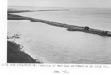
Photograph - Photograph - Lady Bay reclamation, 1960
Port of Portland Authority archivesFront: Lady Bay Reclamation: Dumping of surplus overburden in Lady Bay/ Jan. 1960 (typed below image, centre) Back: Lady Bay Reclamation: Dumping of/ surplus overburden in Lady Bay (blue pen, centre)port of portland archives, lady bay, reclamation -
Glenelg Shire Council Cultural Collection
Photograph - Photograph - Lee Breakwater, Portland, n.d
Port of Portland Authority Archivesport of portland archives, lee breakwater, construction, tanker berth -
Glenelg Shire Council Cultural Collection
Photograph - Photograph - Portland Harbour, n.d
Port of Portland Authority Archivesport of portland archives, lee breakwater -
Glenelg Shire Council Cultural Collection
Photograph - Photograph - Lee Breakwater, Portland, n.d
Port of Portland Authority Archivesport of portland archives, lee breakwater, construction, ocean pier, battery point, k s anderson wharf -
Glenelg Shire Council Cultural Collection
Photograph - Photograph - Lee Breakwater, Portland, n.d
Port of Portland Authority Archivesport of portland archives, lee breakwater, construction, tanker berth, ocean pier -
Glenelg Shire Council Cultural Collection
Photograph - Photograph - Lee Breakwater, Portland, n.d
Port of Portland Authority Archivesport of portland archives -
Glenelg Shire Council Cultural Collection
Photograph - Photograph - Lee Breakwater, Portland, n.d
Port of Portland Archives.Back: (1) 40 ems Wide 133? - pencilport of portland archives, lee breakwater, construction, tanker berth