Showing 297 items
matching brick shops
-
 Stawell Historical Society Inc
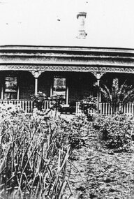
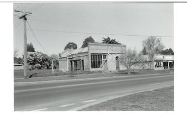
Photograph, Brick home possibly belonging to Mr Isaac Cook
Isaac Cook Saddler Main Street Front view of two chimney brick home with wrap around ornate verandah and verandah railing fence. Believed to be Isaac Cooks home. stawell businesses, shop -
 Stawell Historical Society Inc
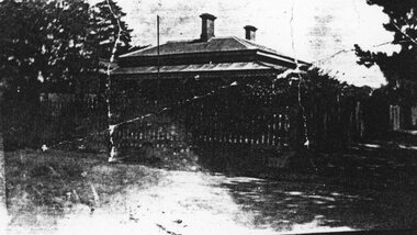
Photograph, Brick home possibly belonging to Mr Isaac Cook
... grampians Isaac Cook Saddler Main Street Stawell Businesses Shop Two ...Isaac Cook Saddler Main Street Two chimney brick home on corner with wrap around ornate verandah and verandah railing fence. Believed to be Isaac Cooks home. Wooden railing fence stawell businesses, shop -
 Whitehorse Historical Society Inc.
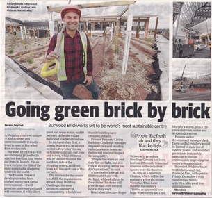
Article, Going Green Brick By Brick, 18/11/2019
Burwood Brickworks has been transformed into an environmentally sustainable shopping centre.Burwood Brickworks has been transformed into an environmentally sustainable shopping centre at 78 Middleborough Road, Burwood East and will open on 6 Dec 2019.Burwood Brickworks has been transformed into an environmentally sustainable shopping centre. brickworks, environmental management, middleborough road burwood east no 78 -
 Whitehorse Historical Society Inc.
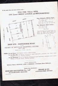
Document, 296 Mitcham Road, Mitcham, 1941
Auction leaflet of a new brick veneer house at 296 Mitcham Road, Mitcham.Auction leaflet of a new brick veneer house at 296 Mitcham Road, Mitcham along with 5 villa sites and a shop site by auctioneers Edward Haughton Pty Ltd and Drake & Co. on 5 Jul 1941.Auction leaflet of a new brick veneer house at 296 Mitcham Road, Mitcham. mitcham road, mitcham no. 296, orient avenue, whitehorse road, mitcham, drake co., edward haughton pty ltd -
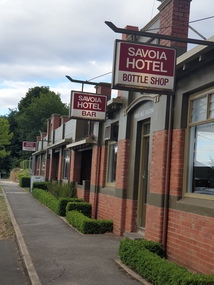 Ballarat Heritage Services
Photograph, Clare Gervasoni, Savoia Hotel, Hepburn Springs, 25/02/2021
Now known as the Savoia Hotel, the original Savoia House was present behind a new brick front until refurbishments in 2022.Colour photograph of Savoia Hotel, Main Road, Hepburn Springs. The hotel is an important site for the Swiss/Italian Community."A focal point for Italian speakers; in 1857 the site included Lorenzo's blackmsiht, Faustino's show shop, Sr Rosetti's Union Store and Giovanettina's Lemonade Store." Swiss & Italian Festa Committee 2012savoia hotel, spring creek hotel, hotels, hepburn springs -
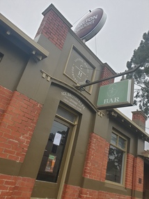 Ballarat Heritage Services
Photograph, Clare Gervasoni, Savoia Hotel, Hepburn Springs, 06/2023
Now known as the Savoia Hotel, the original Savoia House was present behind a new brick front until refurbishments in 2022.Colour photograph of Savoia Hotel, Main Road, Hepburn Springs. The hotel is an important site for the Swiss/Italian Community."A focal point for Italian speakers; in 1857 the site included Lorenzo's blackmsiht, Faustino's show shop, Sr Rosetti's Union Store and Giovanettina's Lemonade Store." Swiss & Italian Festa Committee 2012savoia hotel, spring creek hotel, hotels, hepburn springs -
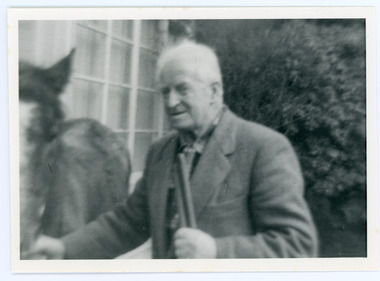 Mt Dandenong & District Historical Society Inc.
Photograph, Edward John Price 1973
John Lundy-Clarke grew up in the Kalorama/Mt Dandenong area and later in life (1972-74) began to write a comprehensive history of the district working from an original settlement map in an effort to cover all areas. Edward John Price (Ted)(1899-1974) was the third child of Edward Joseph and Annie Price. He lived a very industrious life in the area. When the new CRB road cut through the family land Edward John established a Corn and Produce store on a level area adjoining the new road . Along with his brother Charlie, Ted took up road contracting and formed Grange Road in 1923. They also took up contracts to metal the CRB road between The Gap and Olinda. Edward John married Myra Wilson in 1930. They lived in the first brick home built in the district. They had two sons, Edward Joseph 2nd and Alan.Black and white photograph showing an old man dressed in a jacket holding the reins of a horse. Reverse of photograph has handwritten description by John Lundy-Clarke.Edward John Price 1973. Son of Edward Joseph & Annie Ada nee Ross. Born 1899 died 1974. Farmer, Carrier, Sawmiller, Contractor, Quarry Owner, Shop Proprietor (Kew Junction 1935). Father of Alan & Edward J.edward john price, myra wilson, edward joseph price, annie price, alan price, charles price, grange road, crb road -
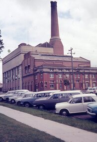 Ballarat Tramway Museum
Photograph - Colour slides - Geelong A Power Station, 1960's and April 1971
1 - Colour slide of the former Geelong A Power Station on the corner of Yarra St and Corio Tce (now Brougham St). First portion on the corner built by the Electric Lighting and Traction Co of Australia. The Geelong tram depot, operated by the Melbourne Electric Supply Co was incorporated within the structure during 1912. Operated by the State Electricity Commission from 1930 until the 1960's. Photo taken prior to the demolition of the chimney during the late 1960's. 2 - Colour slide dated April 1971, taken after the chimney has been demolished. Yields information about the former Geelong A power station prior to its partial demolition and incorporation into a shopping centre. Portions of the original brick buildings have been retained.1 - Green plastic Fuji Film Plastic slide of Photograph of Geelong A Power Station from Yarra St. 2 - Kodachrome cardboard colour slide, date stamped April 1971. No details of Photographer recorded on slide other than the date stamp.geelong, geelong a, power station, mesco, secv, tramways -
 Buninyong & District Historical Society
Photograph - Original B/W Photograph, Former Whyke's Grocer building, Warrenheip St, Buninyong, 18 September 1993
Original building was established by Whyke's family Grocery, built in 1860s. Stripped to apricot brickwork. Verandah removed. Situated East Side of Warrenheip St between Eyre St and Forest St, Buninyong. Building much altered and used as a restaurant in 1970s. Fell into disrepair. Revival took place but not restoration. 1990s under threat of demolition if not conforming to council safety requirements. Building has since been renovated as a pizza restaurant (2023). Vacant lots have since been built on.Established by a prominent local family, an example of a mid 19th century shop. Black and white photo of former Whykes Grocer, 1860's. Streetscape photo of former Whykes Grocer brick building. Power pole with Warrenheip St sign. 3 other shopfronts visible, street trees and vacant land between shops.buninyong, whykes, grocery, building, street scape, warrenheip st -
 Kew Historical Society Inc
Plan, Melbourne and Metropolitan Board of Works, Borough of Kew : Detail Plan No.1580, 1904
The Melbourne and Metropolitan Board of Works (MMBW) plans were produced from the 1890s to the 1950s. They were crucial to the design and development of Melbourne's sewerage and drainage system. The plans, at a scale of 40 feet to 1 inch (1:480), provide a detailed historical record of Melbourne streetscapes and environmental features. Each plan covers one or two street blocks (roughly six streets), showing details of buildings, including garden layouts and ownership boundaries, and features such as laneways, drains, bridges, parks, municipal boundaries and other prominent landmarks as they existed at the time each plan was produced. (Source: State Library of Victoria)This plan forms part of a large group of MMBW plans and maps that was donated to the Society by the Mr Poulter, City Engineer of the City of Kew in 1989. Within this collection, thirty-five hand-coloured plans, backed with linen, are of statewide significance as they include annotations that provide details of construction materials used in buildings in the first decade of the 20th century as well as additional information about land ownership and usage. The copies in the Public Record Office Victoria and the State Library of Victoria are monochrome versions which do not denote building materials so that the maps in this collection are invaluable and unique tools for researchers and heritage consultants. A number of the plans are not held in the collection of the State Library of Victoria so they have the additional attribute of rarity.Original survey plan, issued by the MMBW to a contractor with responsibility for constructing sewers in the area identified on the plan within the Borough of Kew. The plan was at some stage hand-coloured, possibly by the contractor, but more likely by officers working in the Engineering Department of the Borough and later Town, then City of Kew. The hand-coloured sections of buildings on the plan were used to denote masonry or brick constructions (pink), weatherboard constructions (yellow), and public buildings (grey). The area represented in this detail plan has undergone significant change during the 20th century. The widening of High Street in the 1930s and 1950s involved the shops on the south side of High Street being demolished and later rebuilt to fit the widened street. Another significant loss was the mansion ‘Drayton’ fronting Wellington Street, owned at this stage by Susannah Fenton. Her family name would later to be given to Fenton Way, which was to be built over the grounds of the house following its demolition. The plan of the garden is particularly interesting, containing a batten dome fronting Wellington Street, an ornamental pond, a fountain and a brick and glass conservatory. The notes by the plumbing contractor on this plan are particularly detailed. Pink borders delineate the ownership of the varying parcels of land. Some of the better known owners listed include the real estate agent Cr. Henry de Castres Kellett (bt) and John Padbury, the funeral director. This particular plan provides a clear view of the configuration of the Kew Junction in 1903 and the commercial buildings that surrounded it.melbourne and metropolitan board of works, detail plans, maps - borough of kew, mmbw 1580, cartography -
 Kew Historical Society Inc
Plan, Melbourne & Metropolitan Board of Works : Borough of Kew : Detail Plan No.1588, 1904
The Melbourne and Metropolitan Board of Works (MMBW) plans were produced from the 1890s to the 1950s. They were crucial to the design and development of Melbourne's sewerage and drainage system. The plans, at a scale of 40 feet to 1 inch (1:480), provide a detailed historical record of Melbourne streetscapes and environmental features. Each plan covers one or two street blocks (roughly six streets), showing details of buildings, including garden layouts and ownership boundaries, and features such as laneways, drains, bridges, parks, municipal boundaries and other prominent landmarks as they existed at the time each plan was produced. (Source: State Library of Victoria)This plan forms part of a large group of MMBW plans and maps that was donated to the Society by the Mr Poulter, City Engineer of the City of Kew in 1989. Within this collection, thirty-five hand-coloured plans, backed with linen, are of statewide significance as they include annotations that provide details of construction materials used in buildings in the first decade of the 20th century as well as additional information about land ownership and usage. The copies in the Public Record Office Victoria and the State Library of Victoria are monochrome versions which do not denote building materials so that the maps in this collection are invaluable and unique tools for researchers and heritage consultants. A number of the plans are not held in the collection of the State Library of Victoria so they have the additional attribute of rarity.Original survey plan, issued by the MMBW to a contractor with responsibility for constructing sewers in the area identified on the plan within the Borough of Kew. The plan was at some stage hand-coloured, possibly by the contractor, but more likely by officers working in the Engineering Department of the Borough and later Town, then City of Kew. The hand-coloured sections of buildings on the plan were used to denote masonry or brick constructions (pink), weatherboard constructions (yellow), and public buildings (grey). This plan shows the original configuration of the Kew Post Office, Court House and Police Station, which had opened in 1888. This configuration was to essentially remain until the purchase of the Court House and Police Station by the City of Boroondara in 2007 and its subsequent renovation. Interestingly, the MMBW surveyors incorrectly labelled parts of the complex. In the triangle in front of the Post Office, before the erection of the Kew Cenotaph in 1925, was located a lawn and the Queen Victoria Jubilee Fountain. While many of the shops on the south side of High street had been constructed by 1903 a number of sites were still used as vegetable gardens. Further along High Street, on the corner of Charles Street, the Salvation Army Barracks can be seen on the plan. These Barracks predate the later Citadel and ‘Young People’s Hall’ that were opened in 1919. At 22 Charles Street can be seen the house of James Venn Morgan. Hailed as the ‘father of Kew’, Morgan arrived in Melbourne in 1840. He was first engaged as a bookmaker, but a fortunate venture on the goldfields enabled him to purchase land in Kew. He conducted a market garden and dairy in Kew for many years.melbourne and metropolitan board of works, detail plans, maps - borough of kew, mmbw 1588, cartography -
 Kew Historical Society Inc
Photograph - Filling in the Outer Circle Railway cutting at East Kew, 1939
W.D. Vaughan (Kew's Civic Century, 1960, pp.195-6) quotes Council Minutes of 1938 and 1939 to record that: "After protracted negotiations between the Council, the Railways Department and the Tramways Board agreement was reached in June, 1938, for the filling of the railway cutting at the Harp Junction and shifting tram tracks to the High Street alignment ... The Outer Circle railway land from Princess Street to Park Crescent was purchased by the Kew Council in October, 1939, for 2,750 [pounds]. The land from Park Crescent to High Street was leased for 1 [pound] per annum. Considerable work was done in levelling the embankments to the original surface level."Important and rare photograph of the period, showing major works by Kew Council in Kew East working on a significant piece of urban infrastructure.Small, original black and white positive (photograph) showing workers and vehicles filling in the tracks of the former Outer Circle railway at East Kew. In the background is the metal bridge with brick piers, adjacent to the Harp Junction. The bridge crossed the cutting, linking the two parts of High Street. Behind the tip truck, painted on the side with the name 'Fowler Quarries' [located Keilor Road, North Essendon], one can see shops [including T.G. Garroway, Cash Grocer] in High Street. What appears to be the City of Kew Steamroller is immediately in front of the bridge. A group of passers-by watch from the bridge and from the road. Annotation in pencil on verso: "Filling in Outer Circle line at High St East Kew prior to straightening High St. (c. Feb 1930?)outer circle railway, railway cuttings, harp junction, high street -- kew east -
 Kew Historical Society Inc
Slide - Masonic Hall, 3 Walpole Street, 1985
The two-storey red brick with concrete detailing hall building, according to Vaughan (1960) was the 'meeting place for very many lodges in the various degrees of Freemasonry. The first lodge to be established was the Pentalpha Lodge, No. 90'Rare colour photo of a significant hall in Kew, now demolished and replaced with a carpark.35mm colour transparency (slide) of the former Masonic Hall in Walpole Street, Kew. The two-storey red brick with concrete detailing hall building, according to Vaughan (1960). In from of the building is an A-frame sign advertising the Kew Historical Society which at that time (c.1980) shared the building with other organisations under the banner of 'The Copy Shop'. freemasonry -- kew (vic.), masonic hall -- kew (vic.), walpole street -- kew (vic.) -
 Surrey Hills Historical Society Collection
Photograph, Denholm's Garage, 209 Union Road, Surrey Hills
Fred Lyons (cab driver) and Dave Denholm (garage proprietor) worked together in a business servicing cars and providing vehicles for weddings etc. The photo came as part of a donation of photos related to Fred Lyons, his family and business. The building and automotive business was taken over and became J & V Warren-Smith Auto Service. In 2018 it is managed by John and Val's son Phillip and is believed to be the only business in the Union Road shops with a continuous history of use.A back and white photograph of a garage called Union Motor Garage. It has a brick facade, with an arched window either side of the driveway. A petrol bowser stands in front of each window. There is a car in the driveway.On small card: Union Motor Garage / D. B. Denholm, Proptr. / 209 UNION ROAD, SURREY HILLS / Phone Box Hill 959 / AUSTIN OAKLAND / PONTIAC DOUGLAS.::denholm's garage, union motor garage, union road, surrey hills, (mr) dave b. denholm, (mr) fred lyons, petrol stations, petrol pumps, j & v warren-smith auto service -
 Surrey Hills Historical Society Collection
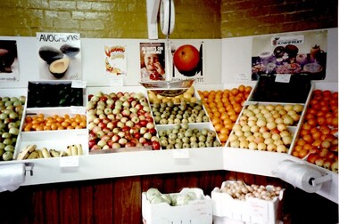
Photograph, Mr Duus fruit shop display in Union Road, Surrey Hills
Mr Duus of Union Road, Surrey Hills was a butcher and greengrocer Note the correct spelling is "DUUS". A 1965 calendar from Duus Brothers is in vertical file under "butchers". Anthony Paul, Edward William and Alan Edward Duus were all butchers. Trevor William Duus was a carrier. In 1980 they all lived in Croydon.Interior of greengrocer shop. Displays of fruit, apples, bananas, oranges, polystyrene boxes of onions, lettuce. Scales suspended from ceiling. Brick walls with posters of fruit and rolls of plastic bags attached to front of display boxes.shops, greengrocer, posters, union road, surrey hills, duus brothers, tony duus, anthony duus -
 Surrey Hills Historical Society Collection
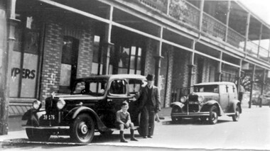
Photograph, Sunbury Crescent, Surrey Hills looking towards the corner of Union Road, 1930s, 1930
Date is approximate. This is one of a series of photos donated by Arthur Lyons. Lyons family history: Arthur's father, Fred Lyons initially worked for George Rea's cab service until he set up his own business. He started with a horse and hansom cab but in time he changed over to a motor vehicle and continued his service until 1960. Frederick Adolphus Lyons (1891-1980) was born in Surrey Hills, son of Thomas and Catherine Lyons. He married Elizabeth Ruby Hall in 1918. They lived at 55 Sunbury Crescent. The Lyons’ home in Sunbury Crescent was called ‘Knopshambury’ - this was probably a misspelling of Knockshanbally in Co Kilkenny, the birth place of Fred’s father, Thomas Edmund Josias Lyons (1846-1915). Arthur Lyons was born in Surrey Hills on 12 Jun 1920. He became a motor mechanic / welder and lived his whole life at 55 Sunbury Crescent. The donation was made while he was in hospital. He died shortly afterwards (23 Sep 1990). Donation was finalised by a neighbour, Mrs Florence Ann Armitstead, wife of Glen Victor Armitstead. Glen was a local hairdresser. They moved to 11 Sunbury Crescent after their marriage in 1939. Arthur had no relatives to distribute the material to. The buildings date from circa 1887 and extended some way down Sunbury Crescent. The address was 63 Sunbury Crescent on the corner of Union Road. Built by Albert Mills for the Premier Land Agency; taken over by Timothy Leigh in 1893. The building housed a variety of shops – initially the land agency, but later shops included at various times a fruiterer, florist, carpenter, fishmonger, upholsterer, plumber. However, by the time this photo was taken in the 1930s it was occupied by Triumph Press. The printing industry continued to have a lasting presence. Triumph Press was followed by Surrey Press and in 1970 New Life Publications moved to the site from Abbotsford. It was about this time that this original building was demolished to make way for a modern print works. Gradually the needs of the printing business absorbed other properties along the Union Road frontage. The boy in the photo is Arthur (Tiger) Lyons and beside him is Alf Johnson, the local printer. The Lyons family lived adjacent to these buildings at 55 Sunbury Crescent.Black and white photo of a section of double-storey terrace buildings in Sunbury Crescent Surrey Hills, taken looking towards the corner of Union Road. The bricks are two-toned and laid in herringbone pattern. The verandah on the 2nd story is filled in with cast-iron lacework panels. There are 2 vintage cars in front of the terrace. A young boy sits on the running board beside a man dressed in suit and hat. printers, vintage cars, sunbury crescent, victorian style, union road shops, arthur lyons, arthur frederick lyons, alf johnson, triumph press, surrey press, new life publications, timothy leigh,, albert mills -
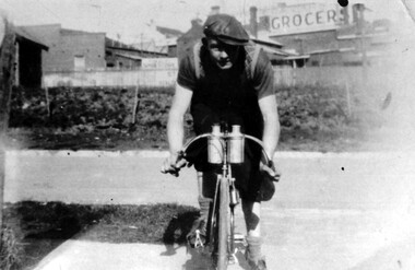 Surrey Hills Historical Society Collection
Photograph, Arthur Lyons of 55 Sunbury Crescent, Surrey Hills
Taken outside the Lyons' home in Sunbury Crescent with Union Road shops in the background. It shows the brick substation which stood by the railway gates. The paling fences are along Stirling Crescent, across the railway line. Arthur was the only son of Frederick Adolphus Lyons (1891-1980) who was born in Surrey Hills, son of Thomas and Catherine Lyons. He married Elizabeth Ruby Hall in 1918. They lived at 55 Sunbury Crescent. The Lyons’ home was called ‘Knopshambury’ - this was probably a misspelling of Knockshanbally in Co Kilkenny, the birth place of Fred’s father, Thomas Edmund Josias Lyons (1846-1915). Arthur Lyons was born in Surrey Hills on 12 Jun 1920. He became a motor mechanic / welder and lived at 55 Sunbury Crescent. This is one of a series of photos donated by Arthur Lyons. The donation was made while he was in hospital. He died shortly afterwards (23 Sep 1990). Donation was finalised by a neighbour, Mrs Florence Ann Armitstead, wife of Glen Victor Armitstead. Glen was a local hairdresser. They moved to 11 Sunbury Crescent after their marriage in 1939. Arthur had no relatives to distribute the material to.A black and white photograph of a man, with his bicycle. In the background is the railway line and buildings one of which has a sign advertising a grocer.sunbury crescent, surrey hills, stirling crescent, railway line, grocers, (mr) arthur lyons, (mr) arthur frederick lyons, cyclist -
 Surrey Hills Historical Society Collection
Photograph, Fred Ambler and Family
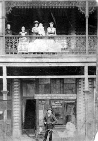
Fred Ambler and family at Albert Mills Premier Land Agency building on the corner of Union and Sunbury Roads, c.1910. Fred had his carpenter and upholstery business on the ground level and his home above. (No.1) Premier Land Agency Building, was built in 1886-7 by Albert Mills, builder, at 122 Union Road, on the corner of Sunbury Crescent, opposite the Railway Station. Photo shows his wife and family. Alfred died in 1890 and the family moved. The Boroondara Standard in 1888 reported: "Splendid block of brick buildings reaching completion in Union Road adjacent to railway line – 2 storey. Frontage 120 feet for Premier Land Agency. Shops at Ground Level." A sepia coloured photograph of a two storey terrace building with 3 ladies and 2 children standing on the balcony. Downstairs, a gentleman stands outside the shopfront beside two prams. There is a child in one pram.albert mills premier land agency building, (mr) fred ambler, union road, carpenter, upholsterer, sunbury crescent -
 Surrey Hills Historical Society Collection
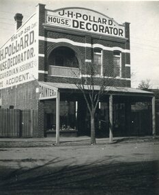
Photograph, Shop of J H Pollard, House Decorator, at 139 Union Road, Surrey Hills, 1930
This site was later occupied by Mitton's pharmacy. James Henry Pollard appears on the 1903 electoral roll as a painter in Canterbury Road (in one of the buildings that made up Hansen's Terrace.)The Union Road shops are covered by a City of Boroondara Heritage Overlay. This particular shop has changed very little with some alteration to the upper storey when it was repurposed for residential dwelling.Black and white photo of James Henry Pollard's shop at 139 Union Road, Surrey Hills in 1930. It is a 2 storey brick building with 2 glass display windows either side of the door and a corrugated iron roofed verandah supported on 3 posts. Above is a dwelling with 2 sash windows and an interior balcony within an arch. A wooden paling fence adjoins on the left. The side of the building and the front pediment carry advertising for the business. From this it appears that James Henry Pollard was an insurance agent for Guardian Assurance Company as well as being a house painter and decorator. There is a deciduous tree in the front of the shop.businesses, shops, mitton's pharmacy, guardian assurance company, union road shops, james henry pollard, painter, decorator -
 Port Fairy Historical Society Museum and Archives
Photograph
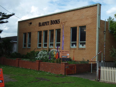
this building was built to house the Port Fairy Masonic Lodge No 67 with two seperate large spaces a general l meeting room in the front and the formal Lodge space to the rear. it is now occupied as a book shop by ‘Blarney Books’Coloured photograph of brick fronted building housing Blarney Booksshop, commercial, port fairy masonic lodge no.67, blarney books, books -
Federation University Art Collection
Artwork - Ceramics, Ceramic Forms by Elsa Adern
Elsa ADERN (1918-2006) Born New Zealand Arrived Melbourne 1942 Elsa Ardern was living at Warrandyte in 1954 when she started studying pottery under John Bernard Knight at the Melbourne Technical College. In 1961 she was a founding member of Potters' Cottage at Warrandyte with friends Sylvia Halpern and Kate Janeba. She worked from a studio under the family home, exhibiting at the cottage and also through the Victorian Ceramic Group when it was set up in 1969. In 1980 she established a workshop at Tathra on the far south coast of NSW, sharing her time between Tathra and Warrandyte for the next 25 years. Amongst the work made at Tathra were some very large pieces which she fired in the Stafford Brothers' wood-fired brick-kiln at Kalaru. Part of the clay for these came from the Staffords' clay-pits. Elsa Adern is known for her strong form of her pots, enhanced by her characteristically subtle wood-ash glazes. Her works are signed with an incised 'Elsa Ardern' or 'EA'. (http://www.australianpotteryatbemboka.com.au/shop/index.php?manufacturers_id=32)available, elsa adern, available ceramics, ceramics -
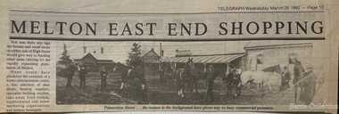 Melton City Libraries
Newspaper, Melton East end shopping, 1992
TOM COLLINS–from the reel to reel tape recording at Melton 1969 In the years between 1890 and to about 1913 Melton was a quiet little hamlet alongside the Toolern Creek, once called the Pennyroyal Creek, 24 miles from Melbourne on the Ballarat Road. There was a fair amount of woodland left around it, mostly grey and yellow box with sheoak, and golden wattle, which in spring time made a rather attractive setting. Most of the premises were in the main or High Street, with its line of elm and pepper trees on each side. Unitt, McKenzie and Henry streets each contained only a few dwellings. Hotels were four in number, Minns’s, Mrs Hay licencee, now Mac’s, Golden Fleece – Sheblers. The Royal or Ryan’s as it was then called, later Graham had the licence, and the Raglan - Kilpatricks had the licence and afterwards Tom Manning. This was situated about where Mr K. Young had his residence. There was a store attached to the hotel until about 1900. Both the Royal and the Raglan were delicensed, later on the Royal being converted to a green grocery and a boarding house, the Raglan was demolished. The Royal green grocery and boarding house was kept by E Carew and after he retired, E Radford. The Post and Telegraph Office was on the opposite side of the street to the Raglan Hotel about two doors west of the Shire Hall and was kept by Mrs Ferris and Lady Farmer until her retirement, when it was carried on by Miss Lottie Ross. A store was attached to the Post Office and was sometimes used as a store and at one time housed the National Bank. There were two full time banks at Melton, the other being the Commercial which built premises about 1904 and on the corner of High and Smith Streets, which it still occupies. Mr G Egan was the manager of the Commercial and Mr Stradling and later Mr Lee of the National. However as business was not thought good enough they reverted to a part time branch operated from Bacchus Marsh. Grocer shops were Chalmers, with a news agency and drapery now Arnolds, Jongebloeds had the bakery. Mr Fox also a produce merchant, was where Melton Real Estate is now, it was later occupied by Buchanans, Atleys, and Mrs Ross. Not long after the War Mrs Ross built the Post Office, since demolished where Miss Lottie Ross was the Post Mistress and later built the store which she conducted. It was later turned into a factory and in now the barbers shop. McNichols was just west of the Minns Hotel. He travelled as far a Ballan weekly, buying calves and dairy produce for sale in Melbourne. Afterwards he sold the business and bought Minns Hotel and changing the name to Macs. Blacksmiths were three in number. Blackwoods – later James Byrnes next door to Jongebloeds. Alex Cameron who learnt his trade with Blackwoods had his shop about the rear of where Ken Youngs Garage is now he later moved to the north west corner of High and Alexander Street. He was also the Registrar of Birth and Deaths and Electoral Registrar. After his retirement he was weighbridge keeper at Melton South. Two of his sons were engaged in the carpentry trade, but both died at an early age. Whittingtons shop was a few doors east of the Mechanics Hall and it was later occupied by Gordon Macdonald who did business there until about eight years ago. The butchers of the period were George Graham, that is where Mandy Lees hairdressing establishment is now. Euan MacDonald had premises later occupied by Whittingtons blacksmith shop. Later shifting next door. He left here about 1901, he slaughtererd animals at a slaughter house right where Chas Jones now resides, it had previously been a slaughter house and butcher shop of that site. George Spring also operated as a butcher for two or three years about the 1900 or so. Ted Simpsons shop was where John Kontek now has his Estate Agency, he used it as an branch shop from Bacchus Marsh bringing meat from there by a two horse lorry. Jimmy Butler the manager was well known and loved, his son was later a steeplechase jockey. The Court House and Police Station would be built sometime before 1900. The Constables at the time were McGuire, later Wade, Riely and McKenzie after that Robert Wilson and Seinfort were here, they were a bit later on. The Mechanics Hall was first opened by Ryan of the Royal Hotel who sold it to the Hall Committee. It was on Unitt Street and it was moved by McLellans the house shifters from Unitt Street to its present site. Bluestone premises formerly occupied by the bootmaker Carew, were later demolished and replaced by the brick frontage to the Hall. Keith Orensini [?] the local bricklayer built brick portion to the Hall. In the cottage adjoining the Hall a Frenchman named Baudin, had a boot repairing business.This cottage was the later residence of J Hill, a local carpenter and builder from whom I learnt my trade. Granny Watts was the well known local nurse and operated the Mid-Wifery Hospital in Yuille Street on the Sherwin Street corner. Mrs Nissen was on the opposite side of Yuille Street a short distance nearer the township. She conducted the laundry. Carew had a greengrocers shop next door to the Post Office in the High Street for some time before transferring to the Royal Hotel site. He also bought [?] calves for killing. W Cecil was a tank maker and also had a produce round, he lived on Pyke and Sherwin Street. Later Gus Shebler, builder and carpenter engaged in tank making being well known for good workmanship. Shebler was very energetic in forming the Gun Club which met for a good number of years where the golf course now has its headquarters. Of the four churches only three are in use, Christ Church, Scots and St Dominics. The Methodist closed down but later transferred to Melton South. Monthly stock sales were held at the yards in Unitt Street at Minns Hotel by McPhail Auctioneers, later held by McCarthur and McLeod. After the Council built the pound and sale yards they transferred sales to these premises, but lack of patronage caused them to be abandoned. A familiar sight in the district was blind Bob Nixon, who lived in a tumbled down cottage in Centenary Road near W Coburns, being led by his dog down the road to Melton, that is Palmerston street, to the Post Office, butcher and baker for his supplies and then back home. He was able to do his own cooking and other chores. Sundays he would come down Raleighs Road to the back of the church and tie his dog to a tree. Someone, mostly one of the boys would guide him into the church and out again after the service, when the dog would lead him home again. State School 430, a two roomed bluestone building it was the only school in the district, none at Melton South. The nearest would be Rockbank and Toolern Vale. Scholars had a fair distance to walk in most cases. The teachers were Mr T Lang Headmaster. I put a query here, Miss Winters, I’m not certain of the name, Mrs Skinner and Miss Silke as Assistant Teachers. Miss Augusta Cecil and Miss Maud Lang were Junior teachers. One boy who attended the school about the turn of the century was Hector Fraser who resided with his parents in Keilor Road, where Jim Gillespie now lives. He was an excellent gun shot and at the age of about 17 years his father took him to France or Monaco where he won the Gran Prix for pigeon shooting and became the champion boy shot of the world. However he died there from pneumonia. He shot under the name of “Parvo”. The Melbourne Hunt Club used to meet in Keilor Road north side just east of the Toolern Creek on what was originally Pykes Run. This was also the place where the races were held and the Sports Meetings. Dave Murphy, employed at Clarke’s Rockbank Station usually provided the fox which he liberated for the Club. Greyhound coursing was usually held on Moylans property Mt Kororoit, or Mt Misery as it was known then. Later it was held at Melton Park, Mr Matt Carberry was the judge and Percy Cook the slipper. Early in the 1900’s the Recreation Park was created and the Caledonian and the ANA sports meetings were held there, they were annual events. L Paterson from Melton South was a successful competitor in all the cycling events as a young man. He later in life became the Deputy Chief Officer of the Metropolitan Fire Brigade. The present Chief Officer of the Fire Brigade is John Paterson, nephew of his, and spent his early life in Exford where his father was manager of the Exford Estate. Notes Tom Collins was born c 1895. He lived on the south side of the Ballarat Road near the intersection of Keilor Road.Historical image of Palmerston Street in Meltonlocal architecture, landscapes of significance -
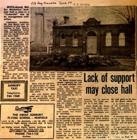 Melton City Libraries
Newspaper, Lack of support may close hall, 1977
"The Mechanics Institute movement flourished in Victoria from 1839 to 1950. It was based on the development of Mechanics’ Institutes in Scotland and England from the 1820s, which were intended to educate and enlighten the working classes. The term ‘mechanic’ in those days meant an artisan, craftsman or working man, especially those who had moved from rural areas to work in new city factories during the Industrial Revolution. The early Institutes were usually equipped with a reading room, a library and a lecture room. Although enjoying mixed success in Britain, they contributed to the development of public education and library services. The movement was adopted more enthusiastically in the colonies. It began slowly in Victoria but its expansion after the gold rushes population influx was rapid, especially in rural areas. Every suburb and town wanted to have a Mechanics’ Institute. During the 1850s approximately forty Institutes were established, with even greater growth in the period 1860 to 1900. By 1900 there were 400 Institutes in Victoria. The establishment of a Mechanics’ Institute was often a great achievement for a local community, requiring organising committees to raise substantial funds for a building site (where this had not been granted by the Government), and the building. Once built, the committee then had to purchase books, provide a caretaker or librarian, and finance the ongoing use of and improvements to the building. ‘The history of many Institutes is a story of tremendous community effort, and often, financial difficulties’. In addition to being monuments to local enterprise and community life, the Mechanics’ Institutes played a vital role as an intellectual forum, and in contributing to an informed and participatory democracy in the late nineteenth and early twentieth centuries. They provided journals and other reading matter on local, state, national and international issues, and hosted of lectures and held debates about wider issues such as Federation, colonial nationalism, defence, female suffrage, the price of land and labour. With the development of the school and technical education in the latter part of the nineteenth century, the need for community technical and adult education declined. As a result of the introduction of government library grants in 1867, many Mechanics’ Institutes incorporated a free library in their buildings to finance collection of their books. By 1884-85, there were 257 free libraries in Victoria. However, government support and library grants dropped off in the 1890s depression. Entertainment took on a greater role in the 1890s, with the introduction of moving pictures, billiards rooms, games rooms (chess), concerts and dances. The First World War had a devastating impact on many rural communities, and some Mechanics’ Institutes were no longer viable. On the other hand the early twentieth century was also a time of agricultural development, and many country towns were growing in this period. The 1930s depression further limited growth of many libraries and reduced grants substantially. In response many Mechanics’ Institutes were renamed, for example as memorial halls, in order to retain and attract more patrons (eg at nearby Sunbury). The diminishing role for Mechanics’ Institutes and the preference for larger and better appointed halls (with supper rooms, cloak rooms etc) resulted in demolition of some small Institutes. The advent of cars, radios, and television also provided other opportunities for recreation, learning and entertainment. The greater role of municipalities in providing library services also eroded the need for free libraries. While over 500 Mechanics’ Institutes or halls are extant, very few of these retain their original role as ‘diffusers of useful knowledge’. Most are still available for community purposes, as venues for meetings, socials, civic occasions etc, while others are employed as museums, shops and theatres. Most buildings are on Crown land, and managed by a delegated committee of management, who are responsible for raising revenue to maintain aging buildings. Many of those which were originally established on private land, such as Melton, have since reverted back to the Crown, and municipal Councils. The most common Mechanics Institute building form is the simple weatherboard gable building with iron roofs, notable for their ‘honest simplicity’ rather than as ‘monuments of the ancients’. At the other extreme there are some magnificent two storeyed brick and stucco structures with elaborate ornamentation (as was apparently envisaged by some in Melton in 1905-10)". The future of Melton Mechanic Institute Gazette articlelocal architecture -
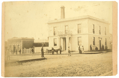 Tarnagulla History Archive
Photograph: Colonial Bank of Australasia (later Union Bank) in Tarnagulla, June 1866
David Gordon Collection. There were four banks in Tarnagulla at one stage, but two - the National Bank and the Bank of Australasia - were open for a short period only. The single-storey brick building at far left was built in 1859 and used by the Union Bank until 1888, and was later renamed 'Lochcarron' and used as premises by doctors and dentists. The two-storey building (right) was built in 1866 by the Colonial Bank of Australasia. Before this, the site had been occupied by Foo's shop. Whilst it was being built, the Colonial Bank operated from Company's Hotel (later known as Burstall Hall and the Council Chambers). The double-storey building in this image was used by the Colonial Bank from 1866 until 21st February, 1888. The premises were sold to the Union Bank for £2500. The Union Bank moved in and commenced operations on 6th June 1888, continuing until 1942. The building was later used as a general store until the 1990s. Both buildings are now private residences. This image was created by Aime Marchand in June 1866. Marchand (1846-1910) made a series of fourteen photographs which were submitted to the 1866-67 Melbourne Intercolonial Exhibition, where they earned a 1st Class Honourable Mention. This is one of those fourteen images. Of French or Belgian origin and possibly formerly an assayer in California, Marchand appears to have begun his practice of photography in Tarnagulla around 1865 as an assistant to A.B. Clay. By the following year he had settled in Portland, where he opened the Royal Photographic Studio in Gawler Street. From his base in Portland he toured surrounding districts, offering portrait and view services. Little else is known about his life. He appears to have left Australia in 1878. A misprint of his name in a local directory as Annie Marchand created the misconception that he was one of only a few named women photographers in the colonies. -
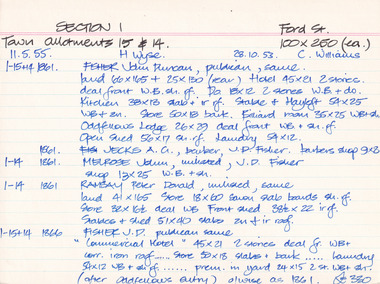 The Beechworth Burke Museum Research Collection
Card - Index Card, George Tibbits, Ford Street, Beechworth, 1976
Property - Ford Street Beechworth - Section 1, Town Allotment 14 & 15 - 100' x 250' each Ownership details and history - 28 Oct 1853 - C. Williams - 11 Nov 1855 - H. Wyse 1-15&14 - 1861 - Fisher, John Duncan - publican, same. Land 66'x165' + 25'x130' (rear) Hotel 45'x21' 2 stories, deal front WB. sh. rf. Do 18'x12' 2 stories WB & Do. Kitchen 38'x13' slab + ir rf. Stable & Hayloft 54'x25' WB & sh. Store 50'x18' bark. Billiard room 35'x25' WB + sh. Oddfellows Lodge 26'x29' deal front WB + sh. rf. Open shed. 56'x17' sh. rf. Laundry 54'x12'. 1861 - Jecks A.G. barber, J.D. Fisher barbers shop 9'x8' 1-14 - 1861 - Melrose, John, unlisted J.D. Fisher shop 13'x25' WB + sh. 1-14 - 1861 - Ramsay, Peter Donald, unlisted, same, land 41'x165' store 18'x60' sawn slab boards sh. rf. store 32'x 16'6"deal WB Front Shed 38'6"x 22' ir rf. 1-15+14 - 1863/4 J.D. Fisher, Hotel as 1861 except store 50'x18' is detached and a shop above De Jecks & Kaliton of a 2 storey residence. 1863/4 - Jecks as above 1-14 - 1863/4 Ramsay - as 1866 1-14 - 1866 - Fisher J.D. - publican, same, "Commercial Hotel" 45'x21' 2 stories deal fr. WB+ corr. Iron roof..... store 50'x18' slabs + bark .... laundry 54'x12' WB + sh. rf. ..... prem. in yard 24'x15' 2 stories WB = sh. (after Oddfellows entry) 0/wise as 1861. £330 1-14 - Jecks A.G. barber, J.D. Fisher, barbers shop 9'x8' £28 1-14 - 1866 - Muirhead, George, Tailor, J.D.Fisher prem 13'x12' WB + Sh. £26 1-14 - 1866 - Ramsay P.D. Spirit dealer, same land 41'x165' front prem 23'x54' bk & ir. rf. Do in rear 32'x16'6" deal fr. WB + sh. rf. Do 8'x8' do---do. Stables + shed 51'x40' slabs, sh+ir. rf. (as1861) £35 1-15+14 1871 - Tanwell, Thomas, publican, same - Hotel as above except. Kitchen 40'x15' bk+iron roof as 1863/4 1861 1-14 - 1871 - Jecks, A.G., T. Tanswell, shop 11'x9' £15 1-14 - 1871 - Goodwin, George, watchmaker, T. Tanswell, sh. 12'x11' £19 [these two were actually entered before 1-14+15] 1-14 - 1871 - Scott, Robert, Wine & Spirit Merchant, P.D. Ramsay land 41'x165' deal fr. WB + sh. rf. Stable & shed 51'x40' slabs + iron roof. 1-15+14 - Tanswell, Thomas, publican, same, land 66'x135' + 25'x130' Hotel front buildings. 65'x35' brick, Back do. 42'x30' brick 2 stories iron roof. Kitchen 40'x15' bk. iron roof. Club room 26'x29' WB. sh. rf. Billiard room 35'x25' WB ir. rf. Prem in yard 24'x15' 2 stories WB sh. rf. Laundry 54'x12' WB sh. rf. Store 50'x18' slabs bark rf. Stables 54'x25' WB sh. rf. Shed 56'x17' £250 1-14 - 1876 - Jecks, A.G. barber T. Tanswell shop £15 1-14 - 1876 - Tanswell, T. publican, same, shop & room in rear £20 1-14 - 1876 - Crawford, Hiram Allen, Connelly, Michael, coach proprietors, Beechworth U.S. Council. Weighbridge £10 1-14 - 1876 - Crawford & Connolly, as above, T. Tanswell. prem as 1871. "23'x55'" & no deal fr. ou prem in rear £52 1-15+14 - 1884 - Tanswell E. Tanswell T. Hotel as above, hotel, billiard clubrooms etc. 1-14 - 1884 - Crawford H.A. - Jackson P.W. - McCurdy W. coach props., B.U.S.C., Weighbridge 1-15+14 - 1884 - Crawford H.A. coach props, T. Tanswell, Commercial stable (at rear) 1-14 - 1884 - Crawford H.A. coach prop, same, office, store, cellar & prem. 1-15+14 - 1889 - Tanswell, Edward. Hotel keeper, T. Tanswell, Comm Hotel Billiard Club + sample rooms, prem + land £175 1-15+14 - 1889 - Crawford, H.A. - Connolly, Thomas - McCurdy, William, coach props, same, Stables, Coach sheds, prems + land £80 1-14 - 1889 - Crawford & Co Ltd., coach props, T. Tanswell, office, store, prem + land £50 1-14 - 1889 - As above. B.U.S.C. Weighbridge £10 1-15+14 - 1900 - Crawford & Co ltd. coach proprietors, excecutors of Tanswell's, stables, offices, coach sheds, factory, land £130 1-15+14 - 1906 - Tanswell, Jane, hotelkeeper, same, hotel, prem + land £150 1-15+14 - 1906 - Tanswell, Jane, Clubrooms, Comm. Hotel £20 1-15+14 - 1906 - Crawford & Co LTD. coach props, Jane Tanswell, stables offices, coach sheds, factory + land £85 Architectural Index Card - Brian Pump and Tony Dugan - Photographers beechworth, george tibbits -
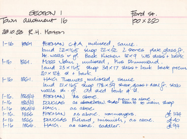 The Beechworth Burke Museum Research Collection
Card (Series) - Index Card, George Tibbits, Ford Street, Beechworth, 1976
... , Thomas, saddler, same, land 10'x39' shop only 10'x39' brick ir.... + cellars 1876 - Haig, Thomas, saddler, same, land 10'x39' shop only ...George Tibbits, University of Melbourne. Faculty of Architecture, Building and Town & Regional PlanningIndex system that support the research for Beechworth : historical reconstruction / [by] George Tibbits ... [et al]Arranged by street names of BeechworthEach index card includes: street name and number of property, image of property, allotment and section number, property owners and dates of ownership, description of the property according to rate records, property floor plan with dimensions.beechworth, george tibbitsbeechworth, george tibbits -
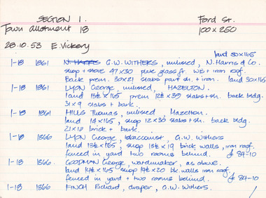 The Beechworth Burke Museum Research Collection
Card (Series) - Index Card, George Tibbits, Ford Street, Beechworth, 1976
... , tobacconist, G.W. Withers land 13'6"x165', shop 13'6"x19' brick walls.... Harris & Co - land 30'x165' shop + store 47'x30' plate glass fr ...George Tibbits, University of Melbourne. Faculty of Architecture, Building and Town & Regional PlanningIndex system that support the research for Beechworth : historical reconstruction / [by] George Tibbits ... [et al]Arranged by street names of BeechworthEach index card includes: street name and number of property, image of property, allotment and section number, property owners and dates of ownership, description of the property according to rate records, property floor plan with dimensions.beechworth, george tibbitsbeechworth, george tibbits -
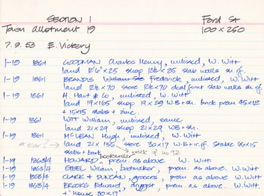 The Beechworth Burke Museum Research Collection
Card (Series) - Index Card, George Tibbits, Ford Street, Beechworth, 1976
George Tibbits, University of Melbourne. Faculty of Architecture, Building and Town & Regional PlanningIndex system that support the research for Beechworth : historical reconstruction / [by] George Tibbits ... [et al]Arranged by street names of BeechworthEach index card includes: street name and number of property, image of property, allotment and section number, property owners and dates of ownership, description of the property according to rate records, property floor plan with dimensions.beechworth, george tibbitsbeechworth, george tibbits -
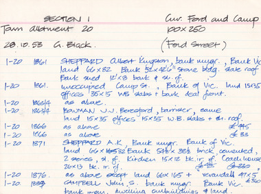 The Beechworth Burke Museum Research Collection
Card (Series) - Index Card, George Tibbits, Cnr Ford and Camp Streets (Ford St), Beechworth, 1976
George Tibbits, University of Melbourne. Faculty of Architecture, Building and Town & Regional PlanningIndex system that support the research for Beechworth : historical reconstruction / [by] George Tibbits ... [et al]Arranged by street names of BeechworthEach index card includes: street name and number of property, image of property, allotment and section number, property owners and dates of ownership, description of the property according to rate records, property floor plan with dimensions.beechworth, george tibbitsbeechworth, george tibbits -
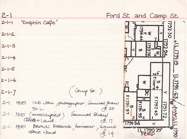 The Beechworth Burke Museum Research Collection
Card (Series) - Index Card, George Tibbits, Cnr Ford and Camp Streets, Beechworth, 1976
George Tibbits, University of Melbourne. Faculty of Architecture, Building and Town & Regional PlanningIndex system that support the research for Beechworth : historical reconstruction / [by] George Tibbits ... [et al]Arranged by street names of BeechworthEach index card includes: street name and number of property, image of property, allotment and section number, property owners and dates of ownership, description of the property according to rate records, property floor plan with dimensions.beechworth, george tibbitsbeechworth, george tibbits