Showing 759 items
matching building projects
-
 Eltham District Historical Society Inc
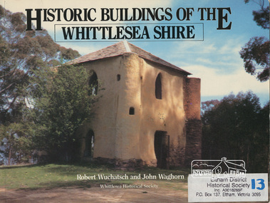
Book, Robert Wuchatsch 1950- et al, Historic buildings of the Whittlesea Shire / Robert Wuchatsch and John Waghorn, 1985
Historical accounts of 55 buildings which portray the Shire of Whittlesea's diverse history. Contains 70 photographs, all full page, 12 in colour. Each is accompanied by a comprehensive account of the homes' origins and changing ownerships through the generations. There are also drawings and a map of the Shire of Whittlesea. Reference to the Peter Lalor Home Building Co-Operative Society Ltd., a project devised to overcome the critical shortage after World War 2. Produced as part of the celebrations for Victoria's 150th anniversary by the Whittlesea Historical Society. A photograph of Bear's Castle at Yan Yean Reservoir is on the cover.Paperback; [114] p. : ill. (some col.), 1 map ; 19 x 25 cm.ISBN 0958866309buildings, shire of whittlesesa, bear's castle -
 Eltham District Historical Society Inc
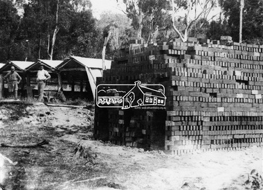
Photograph, Hand made bricks at Hurstbridge
The exceptional building clay of Hurstbridge and throughout the Shire of Eltham and present day Shire of Nillumbik has been a factor in the popularity of manufacture of and use of mud bricks in local architecture. This photo forms part of a collection of photographs gathered by the Shire of Eltham for their centenary project book, "Pioneers and Painters: 100 years of the Shire of Eltham" by Alan Marshall (1971). The collection of over 500 images is held in partnership between Eltham District Historical Society and Yarra Plenty Regional Library (Eltham Library) and is now formally known as 'The Shire of Eltham Pioneers Photograph Collection.' It is significant in being the first community sourced collection representing the places and people of the Shire's first one hundred years.Digital imagesepp, shire of eltham pioneers photograph collection, hurstbridge, brick making, adobe brick, bricks -
 Eltham District Historical Society Inc
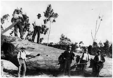
Photograph, Timber felling, Hurstbridge
Six men, some with tools stand on or beside a very large tree which has been recently felled. Pat Ryan identified at front left. In 1920 the Hurstbridge Sawmill operated as part of a local logging industry where among other things large logs were used for bridge building and railway construction. This photo forms part of a collection of photographs gathered by the Shire of Eltham for their centenary project book, "Pioneers and Painters: 100 years of the Shire of Eltham" by Alan Marshall (1971). The collection of over 500 images is held in partnership between Eltham District Historical Society and Yarra Plenty Regional Library (Eltham Library) and is now formally known as 'The Shire of Eltham Pioneers Photograph Collection.' It is significant in being the first community sourced collection representing the places and people of the Shire's first one hundred years.Digital imageWritten on photocopy: "Pat Ryan (front)" with arrow pointing to him "Timber felling for railway construction Diamond Creek - REF 1050"sepp, shire of eltham pioneers photograph collection, hurstbridge, logging, lumber trade, felled tree, railway construction, diamond creek, pat ryan -
 Eltham District Historical Society Inc
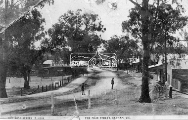
Negative - Photograph, Rose Stereograph Company, The Main Strteet, Eltham, Vic, c.1923
The Rose Series P. 4344 postcard. Similar view to SEPP_0609 taken from near Dudley Street looking north but significantly later in time with numerous stores now constructed on the eastern side south of Pryor Street in what was once Haley's Paddock. Luther Haley sold his bakery store in 1917 and the roof now sports advertising signage for Electrine Candles, presumably coincident with the period of ownership by Hannah Lloyd from 1917 to about February 1920 or Lee’s Railway Store (Messrs J.R. & N.E. Lee 1920-Sep 1922). A boy and a man are standing in the road and the ghost image of three people walking towards them on the footpath just past the store. Ernie Andrew’s combined newsagency and haberdashery/clothing shop with advertising for "The Age" is present at the corner of Arthur Street, on the opposite corner would be the Bootmaker's shop (F. Butterworth, succeeded in 1922 by G.H. McDonald) and William J. Capewell's Butcher shop, second building from right (relocated from in front of the railway station in 1910). North of the News Agency is believed to be Horace H. Clark’s Land and Estate Agency which had also relocated across the road.This photo forms part of a collection of photographs gathered by the Shire of Eltham for their centenary project book,"Pioneers and Painters: 100 years of the Shire of Eltham" by Alan Marshall (1971). The collection of over 500 images is held in partnership between Eltham District Historical Society and Yarra Plenty Regional Library (Eltham Library) and is now formally known as the 'The Shire of Eltham Pioneers Photograph Collection.' It is significant in being the first community sourced collection representing the places and people of the Shire's first one hundred years.Digital image 120 format B&W negative (copy of original postcard)shire of eltham pioneers photograph collection, eltham, main road, bootmakers, butcher, dudley street, electrine candles, eltham town centre, hannah lloyd, lloyd's general store, newsagency, pryor street, rose series postcard, shops, william james capewell, ernie andrew, f. butterworth, g.h. mcdonald, haley's paddock, j.r. lee, lee's railway store, n.e. lee, rose stereograph company -
 Eltham District Historical Society Inc
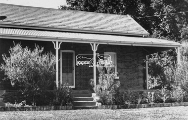
Negative - Photograph, Leader Publishing Co, Wingrove Cottage, c.1970
Wingrove Cottage is historically significant for its long association with Charles Wingrove, a prominent figure in Victorian local government, as secretary to the Eltham District Road Board and Shire Council from 1858 to 1904, and Shire Engineer and Secretary to the Heidelberg Road Board. The cottage was also used as the office of the Eltham District Road Board and Council for many years . One of the Shire's oldest dwellings, and one of the few surviving 19th century buildings associated with early Eltham and located in the original Eltham Village Reserve. Wingrove Cottage is considered historically significant to the Shire of Nillumbik and is registered on the Victorian Heritage Database. This photo forms part of a collection of photographs gathered by the Shire of Eltham for their centenary project book,"Pioneers and Painters: 100 years of the Shire of Eltham" by Alan Marshall (1971). The collection of over 500 images is held in partnership between Eltham District Historical Society and Yarra Plenty Regional Library (Eltham Library) and is now formally known as the 'The Shire of Eltham Pioneers Photograph Collection.' It is significant in being the first community sourced collection representing the places and people of the Shire's first one hundred years.Digital image 4 x 5 inch B&W Neg Print 20 x 25 cmsepp, shire of eltham pioneers photograph collection, eltham, wingrove cottage, charles wingrove, houses -
 Eltham District Historical Society Inc
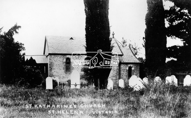
Photograph, St. Katherine's Church, St. Helena, Vic
Located at 277-279 St Helena Road Saint Helena, Victoria. In 1841 Anthony Beale, born on the Island if St Helena took a pastoral lease on the Plenty River where he built a cottage, St Helena, which ultimately gave this area its name. Beale's wife Katherine Rose, nee Young died in 1856 and he erected "The rose Chapel" to her memory. After his death in 1865 the chapel was willed to the Church of England and consecrated in 1876. It was severely damaged by bushfire in 1957. It was fully restored and rededicated in November 1957. The bell calls parishoners to Sunday services is believed to a have come from the Island of St Helena. Source: Mr. A.E. Parsons, Pryor St., Eltham (Mrs. Glasgow - daughter)Statement of Significance Last updated on - October 10, 2005 St Helena's is a rare surviving example of a churchyard cemetery. It is of local historical significance because of its association with the local pioneering family, the Beales, and other notable citizens including Walter Withers and Graham Webster. The cemetery is also the oldest in the municipality, of State significance. The high level of maintenance and the rural ambience contribute to the overall significance of the site. St Katherine's Church building has been reconstructed and is of local historical interest, principally for its value in interpreting the original setting within the Cemetery. It contains stained glass windows of local historical significance, commemorating casualties of the Beale family in World War One. - Victorian Heritage Database This photo forms part of a collection of photographs gathered by the Shire of Eltham for their centenary project book,"Pioneers and Painters: 100 years of the Shire of Eltham" by Alan Marshall (1971). The collection of over 500 images is held in partnership between Eltham District Historical Society and Yarra Plenty Regional Library (Eltham Library) and is now formally known as the 'The Shire of Eltham Pioneers Photograph Collection.' It is significant in being the first community sourced collection representing the places and people of the Shire's first one hundred years.Digital image"St Katharine's Church, St Helena, Victoria"sepp, shire of eltham pioneers photograph collection, other areas, st katherine's church, st helena -
 Eltham District Historical Society Inc
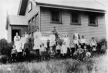
Photograph, Queenstown North State School, c.1910
School building now at Berwick State School (for short time was used at Queenstown North for some sort of home for boys) - Kent Hughes. Cross Ref: 0151This photo forms part of a collection of photographs gathered by the Shire of Eltham for their centenary project book,"Pioneers and Painters: 100 years of the Shire of Eltham" by Alan Marshall (1971). The collection of over 500 images is held in partnership between Eltham District Historical Society and Yarra Plenty Regional Library (Eltham Library) and is now formally known as the 'The Shire of Eltham Pioneers Photograph Collection.' It is significant in being the first community sourced collection representing the places and people of the Shire's first one hundred years.Digital image, 9 x 12.5 cm print and 4 x 5 inch B&W Neg sepp, shire of eltham pioneers photograph collection, queenstown, st andrews, queenstown state school no. 3594 -
 Eltham District Historical Society Inc
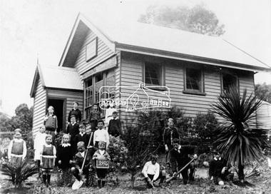
Photograph, Queenstown North State School, No. 3594, c.1915
School building now at Berwick State School (for short time was used at Queenstown North for some sort of home for boys) - Kent Hughes. Cross Ref: 0150This photo forms part of a collection of photographs gathered by the Shire of Eltham for their centenary project book,"Pioneers and Painters: 100 years of the Shire of Eltham" by Alan Marshall (1971). The collection of over 500 images is held in partnership between Eltham District Historical Society and Yarra Plenty Regional Library (Eltham Library) and is now formally known as the 'The Shire of Eltham Pioneers Photograph Collection.' It is significant in being the first community sourced collection representing the places and people of the Shire's first one hundred years.Digital image, 9 x 12.5 cm print and 4 x 5 inch B&W Negsepp, shire of eltham pioneers photograph collection, queenstown, st andrews, queenstown state school no. 3594 -
 Eltham District Historical Society Inc
Negative - Photograph, Eltham War Memorial Obelisk 1914-1918, cnr. Main Road and Bridge Street, c.1925
Located on what was referred to as Obelisk Corner, improvements have been been made since the unveiling in August 1919 with the provision of a stone retaining wall topped with a chain link and granite stone boundary, most likely in conjunction with improvements to the intersection into Main Road. Along with the use of the name Obelisk Corner, the Bridge Street bridge was also known as Obelisk Bridge. The Eltham Obelisk was originally located at the corner of Bridge and Main Roads in 1919. In 1943 (WW2) the local community commenced plans to establish the Eltham War Memorial, a living memorial to benefit the children as opposed to a one in stone as per the obelisk. The Eltham War Memorial Trust was established in 1945. In 1947 the Trust intended for the Obelisk to be relocated from Bridge Street and Main Road to the Garden of Remembrance which was planned as part of the Baby Health Centre which was to be the first of three buildings of the Eltham War Memorial to be built in 1951. In 1951 the Eltham RSL was invited to be represented on the Eltham War Memorial Trust. Around this time, with pending roadworks, the obelisk was relocated to the front garden of the Eltham RSL sub branch on Main Road for safe keeping. In 2007, a suggestion was proposed by Harry Gilham (President, EDHS) to John Cohen (ERSL) to claim a special site along with the historic Shillinglaw trees on the now vacant former Eltham Shire Office site adjacent to the Eltham War Memorial precinct for relocation of the obelisk. In 2010 following the financial collapse and sale of the Eltham RSL Sub-Branch property and amalgamation with the Montmorency Eltham RSL sub-branch, the location of the obelisk was again in immediate jepoardy and in conjunction with Nillumbik Shire Council, the obelisk was relocated in front of the Eltham War Memorial buildings in preparation for the Dawn Service on Anzac Day 2012.This photo forms part of a collection of photographs gathered by the Shire of Eltham for their centenary project book,"Pioneers and Painters: 100 years of the Shire of Eltham" by Alan Marshall (1971). The collection of over 500 images is held in partnership between Eltham District Historical Society and Yarra Plenty Regional Library (Eltham Library) and is now formally known as the 'The Shire of Eltham Pioneers Photograph Collection.' It is significant in being the first community sourced collection representing the places and people of the Shire's first one hundred years.Digital image 4 x 5 inch B&W Negsepp, shire of eltham pioneers photograph collection, eltham, main road, eltham war memorial, bridge street, obelisk, obelisk corner -
 Eltham District Historical Society Inc
Photograph, View in Eltham looking south along Main road from Bridge Street, 1902
Looking south along Main Road from the south side of the intersection of Bridge Street with Main Road. Post Office (Anne Hunniford Postmistress) on left then the Commercial Bank of Australasia building. The house on the right, 'Derril,' was purchased by Walter Gahan in 1924 and was demolished in 1968 when Main Road was widened. In the distance on the left is Watson's Hotel and on the right (opposite side of the main road, Morris's Hotel Cross Ref: 0624This photo forms part of a collection of photographs gathered by the Shire of Eltham for their centenary project book,"Pioneers and Painters: 100 years of the Shire of Eltham" by Alan Marshall (1971). The collection of over 500 images is held in partnership between Eltham District Historical Society and Yarra Plenty Regional Library (Eltham Library) and is now formally known as the 'The Shire of Eltham Pioneers Photograph Collection.' It is significant in being the first community sourced collection representing the places and people of the Shire's first one hundred years.Digital image Print 14 x 24 cm 35 mm B&W negativeanne jane hunniford (1855-1928), bridge street, commercial bank of australia, derril, eltham, gahan house, main road, morris's hotel, post office, shire of eltham pioneers photograph collection, watsons hotel -
 Eltham District Historical Society Inc
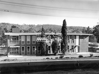
Photograph, Eltham Shire Office, shortly after duplication of Main Road, c.1968
Eltham Shire Council office built 1964 on the former site of Shillinglaw Cottage. In 1971 the offices were extended with a southern wing (to the left of the building) which housed the Eltham Library and planning offices. Taken shortly after widening of Main Road between Pitt Street and Elsa Court which was undertaken between February 1968 and August 1968. Image was most probably commissioned by Eltham Shire Council and taken by Hugh Fisher, photographer who operated from premises between Arthur and Dudely streets and was often contracted by the shire for official photographic work. The image was used in the August 1971 issue of Australian Municipal Journal This photo forms part of a collection of photographs gathered by the Shire of Eltham for their centenary project book,"Pioneers and Painters: 100 years of the Shire of Eltham" by Alan Marshall (1971). The collection of over 500 images is held in partnership between Eltham District Historical Society and Yarra Plenty Regional Library (Eltham Library) and is now formally known as the 'Shire of Eltham Pioneers Photograph Collection'. It is significant in being the first community sourced collection representing the places and people of the Shire's first one hundred years.Digital image and 120 format B&W negativesepp, shire of eltham pioneers photograph collection, eltham, main road, duplication, road widening, shillinglaw trees, local government -
 Eltham District Historical Society Inc
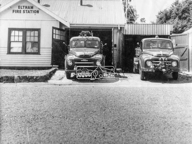
Photograph, George W. Bell, Eltham Fire Station, east side of Main Road, c.Jan 1964
The photograph was taken (and donated) by George W. Bell during the period of fire, c.1963-c.1964. The actual fire station was built c.1930 and was in use till c.1964 when a new fire station was built on the opposite side of Main Road. The building, originally situated just south of Arthur Street, on Main Road was ultimately relocated in 1970 to Research Park for use by the 1st Research Scout group. The site is now part of the current Coles supermarket and Eltham Village complex. The Fire Trucks are an Austin STU (small town unit) on the left and an Austin urban pumper on the right. This photo forms part of a collection of photographs gathered by the Shire of Eltham for their centenary project book,"Pioneers and Painters: 100 years of the Shire of Eltham" by Alan Marshall (1971). The collection of over 500 images is held in partnership between Eltham District Historical Society and Yarra Plenty Regional Library (Eltham Library) and is now formally known as 'The Shire of Eltham Pioneers Photograph Collection.' It is significant in being the first community sourced collection representing the places and people of the Shire's first one hundred years.Digital imageaustin stu fire truck, austin urban pumper, eltham, eltham fire brigade, fire station, fire truck, george w. bell, motor vehicles, shire of eltham pioneers photograph collection -
 Eltham District Historical Society Inc
Photograph, Margaret Ball, Stebbing's Cottage, 88 Pitt Street, Eltham, June 1999
One of the oldest houses in Eltham, the cottage was built around 1861 by pioneer builder George Stebbing whose family lived in it until the 1900s. It’s plain and simple style reflects the functional design of the house. George Stebbing was responsible for the construction of some of Eltham's principal township buildings, including the Uniting (former Methodist) church, St. Margaret's Anglican church (1861) and Shillinglaw Cottage (1879). The house is historically and aesthetically significant because it is a rare surviving example of the modest homes constructed for and by artisans within the early Eltham township and is a significant feature of the streetscape In the 1960s Albert Downing owned this propertyThe Margaret Ball (Pre 1960s Houses) Collection was a personal project initiated to mark the year 2000 and arose as a result of the disappearance of many pre-1960s parts of Eltham due to development. Approximately 200 pre-1960s style houses that were left in Eltham between Main Road and east to Bible Street, between Cecil Street to the north and south to Dalton Street were photographed in late 1999. Not all of the houses could be photographed; some because the garden or trees blocked the view of the house, others because of rubbish or cars were in the way, some because people were working on the house or in the gardens at the time.Colour photographic print eltham, houses, streets, margaret ball (pre 1960s houses) collection, pitt street, stebbing's cottage, downing -
 Eltham District Historical Society Inc
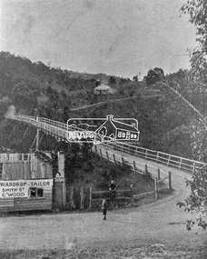
Photograph, Warrandyte Bridge on River Yarra
Bridge across the Yarra River which links North Warrandyte and Warrandyte. A house sits prominantly on a hill in the distance. A wooden building on the side of the road before the bridge has advertising for Wardrop Tailor, Smith Street, Collingwood. It is suggested that the photo has had this fake information added at a later date. Wardrop Tailor did operate from about 1915 to 1921. Alternataive title: Warrandyte Bridge - River Yarra. "Wardrop-Tailor, Smith St. C'wood" sign - faked?This photo forms part of a collection of photographs gathered by the Shire of Eltham for their centenary project book,"Pioneers and Painters: 100 years of the Shire of Eltham" by Alan Marshall (1971). The collection of over 500 images is held in partnership between Eltham District Historical Society and Yarra Plenty Regional Library (Eltham Library) and is now formally known as 'The Shire of Eltham Pioneers Photograph Collection.' It is significant in being the first community sourced collection representing the places and people of the Shire's first one hundred years.Digital imagesepp, shire of eltham pioneers photograph collection, warrandyte, bridge, north warrandyte, yarra river, wardrop tailor, collingwood -
 Eltham District Historical Society Inc
Negative - Photograph, George W. Bell, State School No. 209, Dalton Street, Eltham, c.1960
Eltham Primary School. This building is the earliest building remaining on site today. It was built in 1875 and was the second school building replacing the original1856 building of stone walls with wooden shingles on the roof. That building needed to be replaced after the stone walls collapsed outwards.This photo forms part of a collection of photographs gathered by the Shire of Eltham for their centenary project book,"Pioneers and Painters: 100 years of the Shire of Eltham" by Alan Marshall (1971). The collection of over 500 images is held in partnership between Eltham District Historical Society and Yarra Plenty Regional Library (Eltham Library) and is now formally known as the 'The Shire of Eltham Pioneers Photograph Collection.' It is significant in being the first community sourced collection representing the places and people of the Shire's first one hundred years.Digital image 4 x 5 inch B&W Negsepp, shire of eltham pioneers photograph collection, eltham, dalton street, eltham state school, eltham primary school, george w. bell collection, schools, state school no. 209 -
 Eltham District Historical Society Inc
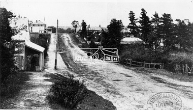
Negative - Photograph, Bridge on Main Road, Eltham, c.1890
Possibly produced as a postcard. Caption in lower right hand corner reads: Bridge (at) Main Road Eltham. The long wooden suspension bridge over the Diamond Creek on Main Road at Eltham collapsed during flooding of the Diamond Creek on October 13 and 14, 1923. The original bridge was built around 1840 for the coach road when Cobb & Co.'s coach was the only conveyance between Eltham and Melbourne. Widespread damage was done in Melbourne and surrounding areas by floods resulting from the overflow of the Yarra at many points along its banks. A temporary bridge rigged up was severely damaged by the flooding of the creek and was closed to vehicular traffic in April 1924. A new concrete bridge was constructed to replace it and by May 1926 all the concrete piles and abutments had been completed. The bridge was finally completed and opened for traffic in September 1926, almost three years after it initially collapsed. Viewed from Antoinette Boulevard looking northwest towards Falkiner Street. The building in the distance believed to be Souters Cottage. On the far right on the very edge of the road verge are two Eucalypt trees, one of which is believed to be the large dead trunk still standing in present day.This photo forms part of a collection of photographs gathered by the Shire of Eltham for their centenary project book,"Pioneers and Painters: 100 years of the Shire of Eltham" by Alan Marshall (1971). The collection of over 500 images is held in partnership between Eltham District Historical Society and Yarra Plenty Regional Library (Eltham Library) and is now formally known as the 'The Shire of Eltham Pioneers Photograph Collection.' It is significant in being the first community sourced collection representing the places and people of the Shire's first one hundred years.Digital image 4 x 5 inch B&W Neg Black and white print 35mm positive transparencyshire of eltham pioneers photograph collection, eltham, main road bridge, eltham south, bridge, diamond creek (creek), significant tree, souters cottage, eltham lower park, main road, sepp -
 Eltham District Historical Society Inc
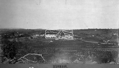
Negative - Photograph, Eltham, Vic, c.1890
View looking northeast from present day Ely Street (near intersection of present day Cronus Court and Porter Street) across what will become the site of Eltham High School towards Main Road showing the Eltham Courthouse and Police station. View is very similar to the sketch of Eltham published in 'The Illustrated Australasian News', December 26, 1884, p212. Note the large bluestone cell block behind police house and stable. George Knapman's Shoeing Forge next to the courthouse and the concentration of buildings around the Evelyn Hotel and Watson's Eltham Hotel on opposite sides of Main Road at Pitt street. Also note George Stebbing's cottage (c.1860) on Pitt Street behind the courthouse and 'Sunnyside' (home of W.J. Taylor built c.1885) at the top of the hill on Bible Street. In the foreground are orchards running up to the main street, Maria Street and also between Brougham Street and Dalton Street bordered by Bible Street.This photo forms part of a collection of photographs gathered by the Shire of Eltham for their centenary project book,"Pioneers and Painters: 100 years of the Shire of Eltham" by Alan Marshall (1971). The collection of over 500 images is held in partnership between Eltham District Historical Society and Yarra Plenty Regional Library (Eltham Library) and is now formally known as the 'The Shire of Eltham Pioneers Photograph Collection.' It is significant in being the first community sourced collection representing the places and people of the Shire's first one hundred years.Digital image 4 x 5 inch B&W Negshire of eltham pioneers photograph collection, eltham, 1890, bible street, brougham steet, dalton street, eltham courthouse, eltham hotel, evelyn hotel, franklin street, grant house, knapmans forge, main road, maria street, orchards, police residence, police station, pre 1900, stebbing cottage, sunnyside, w.b. andrew corn store, watsons hotel, little eltham -
 Eltham District Historical Society Inc
Photograph, Eltham War Memorial 1914-1918. Cnr. Main Road and Bridge Street, 3 August 1919
Dated 1919, the Eltham Obelisk is decorated with wreaths, most likely for what was originally known as Armistice Day though now known as Remembrance Day, 11 November. The location of the Obelisk at the corner of Bridge Street and Main Road became known as Obelisk Corner and the Bridge Street bridge was also referred to as Obelisk Bridge. The Eltham Obelisk was originally located at the corner of Bridge and Main Roads in 1919. In 1943 (WW2) the local community commenced plans to establish the Eltham War Memorial, a living memorial to benefit the children as opposed to a one in stone as per the obelisk. The Eltham War Memorial Trust was established in 1945. In 1947 the Trust intended for the Obelisk to be relocated from Bridge Street and Main Road to the Garden of Remembrance which was planned as part of the Baby Health Centre which was to be the first of three buildings of the Eltham War Memorial to be built in 1951. In 1951 the Eltham RSL was invited to be represented on the Eltham War Memorial Trust. Around this time, with pending roadworks, the obelisk was relocated to the front garden of the Eltham RSL sub branch on Main Road for safe keeping. In 2007, a suggestion was proposed by Harry Gilham (President, EDHS) to John Cohen (ERSL) to claim a special site along with the historic Shillinglaw trees on the now vacant former Eltham Shire Office site adjacent to the Eltham War Memorial precinct for relocation of the obelisk. In 2010 following the financial collapse and sale of the Eltham RSL Sub-Branch property and amalgamation with the Montmorency Eltham RSL sub-branch, the location of the obelisk was again in immediate jepoardy and in conjunction with Nillumbik Shire Council, the obelisk was relocated in front of the Eltham War Memorial buildings in preparation for the Dawn Service on Anzac Day 2012.This photo forms part of a collection of photographs gathered by the Shire of Eltham for their centenary project book,"Pioneers and Painters: 100 years of the Shire of Eltham" by Alan Marshall (1971). The collection of over 500 images is held in partnership between Eltham District Historical Society and Yarra Plenty Regional Library (Eltham Library) and is now formally known as 'The Shire of Eltham Pioneers Photograph Collection.' It is significant in being the first community sourced collection representing the places and people of the Shire's first one hundred years.Digital image 4 x 5 inch B&W Negsepp, shire of eltham pioneers photograph collection, eltham, main road, bridge street, eltham war memorial, obelisk, obelisk corner, wreath -
 Eltham District Historical Society Inc
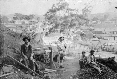
Photograph, Early Goldmine
Four male gold miners pose for the camera on their mine site on top of a hill. It appears they are using the underground hard-rock method of mining to extract gold encased in rock. There is a rope winch near by and a pile of rubble on top of the mine shaft. In the background is a developed unknown rural town. "H & J Friend Victoria Stores" is written on the side of a building.This photo forms part of a collection of photographs gathered by the Shire of Eltham for their centenary project book, "Pioneers and Painters: 100 years of the Shire of Eltham" by Alan Marshall (1971). The collection of over 500 images is held in partnership between Eltham District Historical Society and Yarra Plenty Regional Library (Eltham Library) and is now formally known as 'The Shire of Eltham Pioneers Photograph Collection.' It is significant in being the first community sourced collection representing the places and people of the Shire's first one hundred years.Digital imagesepp, shire of eltham pioneers photograph collection, other areas, gold mining, gold miners, h & j friend, winch -
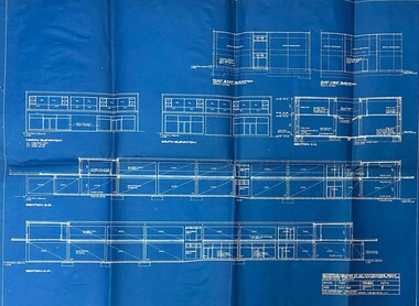 Ringwood and District Historical Society
Document - Architect's Blue Print, 147 Whitehorse Road , Ringwood, Victoria - 1955
Blue print for shopping arcade at 147 Whitehorse Road, Ringwood, for Ringwood Investments Pty. Ltd. Rubber stamped on back and signed off by Borough of Ringwood Building Surveyor 24/5/1955, "Approved subject to Building Regulations and Bye-Laws." Architect for the project was P.E. Jorgensen, Collins House, 360 Collins Street, Melbourne. -
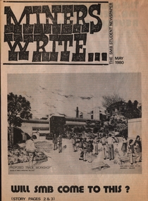 Federation University Historical Collection
Newspaper - Newspaper - Broadsheet, ZILLES COLLECTION: SMB Student Newspaper; "Miners Write", May 1980, 05/1980
4 sheets folded plus single sheet half the size - 8 plus 2 pagesnon-fictionballarat school of mines, miners write, newspaper, building plans, graham beanland, principal, letters to the editor, sporting results, evan jones & associates, architects, twelve angry men, pentridge prison, barry hall, jim burns, lorene guley, glenn keating, karen knight, greg smith, robert smith, rohan souter, jeff zilles -
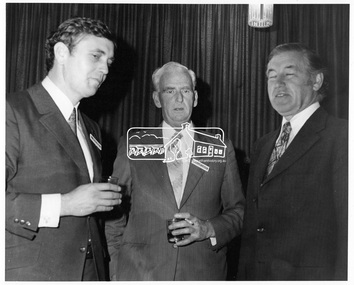 Eltham District Historical Society Inc
Photograph, Austin Hospital Appeal for Stage 2 Building Appeal, 4 Jul 1973
Luncheon reception held at Austin Hospital, Heidelberg to open appeal for the Stage 2 Building Appeal. L-R: Mr. Colin J. Bock, Shire secretary/Chief Administrative Officer, Cr. J.O. White J.P., Shire President, The Hon. R.J. Hamer, E.D., M.P., Premier of Victoria, and treasurer and Minister of the Arts. The July 1973 appeal's target was $500,000, which with government subsidies aimed to pay for a nine-story building alongside stage one - a combined ten-storey teaching, research and medical centre. The new block was planned to provide the Austin Hospital with 218 additional beds, eight extra operating theartres and a comprehensive range of medical, diagnostic, therapeutic and anciliary services. The hospital conducted a door knock appeal in the Heidelberg and Eltham districts on Sunday July 22.This photo forms part of a collection of photographs gathered by the Shire of Eltham for their centenary project book, "Pioneers and Painters: 100 years of the Shire of Eltham" by Alan Marshall (1971). The collection of over 500 images is held in partnership between Eltham District Historical Society and Yarra Plenty Regional Library (Eltham Library) and is now formally known as 'The Shire of Eltham Pioneers Photograph Collection.' It is significant in being the first community sourced collection representing the places and people of the Shire's first one hundred years.Digital image 120 format B&W negative EDHS_01922 (4 strips, 12 frames - Frame 8)austin hospital, austin hospital appeal, austin hospital appeals committee, colin j. bock, cr. j.o. white, fundraising, heidelberg, hon. r.j. hamer, other areas, p.j. catchlove, premier of victoria, rupert hamer, sepp, shire of eltham pioneers photograph collection, shire president, victorian premier -
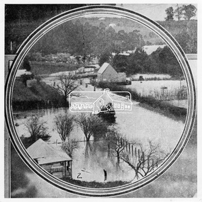 Eltham District Historical Society Inc
Photograph, Leader Publishing Co, Floods at Diamond Creek, Sep. 1924
The Diamond Creek in flood in Diamond Creek township. View north along Diamond Street. The building in the middle distance is the Methodist Church. From "The Leader", 6 September 1924.This photo forms part of a collection of photographs gathered by the Shire of Eltham for their centenary project book, "Pioneers and Painters: 100 years of the Shire of Eltham" by Alan Marshall (1971). The collection of over 500 images is held in partnership between Eltham District Historical Society and Yarra Plenty Regional Library (Eltham Library) and is now formally known as 'The Shire of Eltham Pioneers Photograph Collection.' It is significant in being the first community sourced collection representing the places and people of the Shire's first one hundred years.Digital imageshire of eltham pioneers photograph collection, diamond creek, floods, methodist church, diamond creek (creek), diamond street, 1924 -
 Eltham District Historical Society Inc
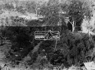
Photograph, Allwood, Hurstbridge, 1885
Allwood at Hurstbridge was named and first settled in 1837 by the Haley family. A house was built of one round of vertical slabs (red gum). Later it was the Hurst family home where Henry Hurst was shot by Burke the Bushranger on 4 October 1886. George Gray took over the property and the original home was eventually demolished. Gray, a fruit grower established an orchard and Allwood Nurseries which became a very successful business growing and exporting. This is probably around the time when this photo was taken where rows of fruit trees can be seen in the foreground. A house and associated buildings, possibly part of the nursery are behind. This photo forms part of a collection of photographs gathered by the Shire of Eltham for their centenary project book, "Pioneers and Painters: 100 years of the Shire of Eltham" by Alan Marshall (1971). The collection of over 500 images is held in partnership between Eltham District Historical Society and Yarra Plenty Regional Library (Eltham Library) and is now formally known as 'The Shire of Eltham Pioneers Photograph Collection.' It is significant in being the first community sourced collection representing the places and people of the Shire's first one hundred years.Digital imagesepp, shire of eltham pioneers photograph collection, diamond creek, hurstbridge, allwood, orchard -
 Eltham District Historical Society Inc
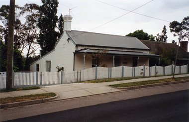
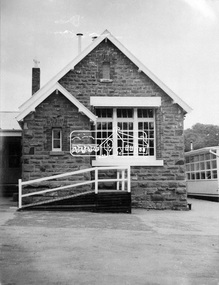
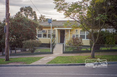
Photograph, Margaret Ball, Police Station, Pryor Street, Eltham, June 1999, 1999
In 1959 the Victoria Police purchased this house in Pryor Street to be refurbished as the Eltham Police Station. In 1961 the Police moved out of 728 Main Road and into the Pryor Street building following required modifications to bring it in line with the standards used for Police Stations throughout the State.The Margaret Ball (Pre 1960s Houses) Collection was a personal project initiated to mark the year 2000 and arose as a result of the disappearance of many pre-1960s parts of Eltham due to development. Approximately 200 pre-1960s style houses that were left in Eltham between Main Road and east to Bible Street, between Cecil Street to the north and south to Dalton Street were photographed in late 1999. Not all of the houses could be photographed; some because the garden or trees blocked the view of the house, others because of rubbish or cars were in the way, some because people were working on the house or in the gardens at the time.Roll of 35mm colour negative film, 10 stripsFuji 200eltham, houses, streets, margaret ball (pre 1960s houses) collection, pryor street, police station -
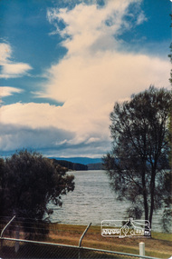
 Eltham District Historical Society Inc
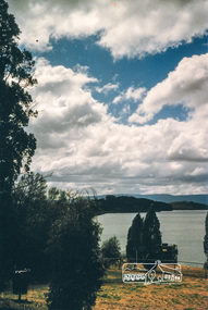
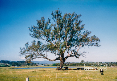
Photograph, Yan Yean, 1987, 1987
Originally contained in a 'magnetic' photo album of scenic photos of Yan Yean and Warrandyte believed to be donated by Mrs Eric Stephenson, Jingalong, 110 Ryans Road, Eltham, Vic. 3095; relocated to archival safe storage. On the 20th December 1853 Lieut Governor Charles LaTrobe took his spade to turn the first sod of an embankment across the swampy bed of the Plenty River at a lonely place called Yan Yean, in order to create Melbourne’s first water supply. In the early 1850’s water had been drawn from the Yarra which even then was known as Yarra Soup. A convict by the name of James Blackburn produced the basic design for supplying water to Melbourne from a reservoir on the Plenty River at Yan Yean, and later on he was appointed consulting engineer on the project. In 1853 a contract was let for the building of the wall for 91 thousand 575 pounds, and at one stage some 400 labourers were at work in the area. A tramway was constructed to convey stone and other materials from Melbourne. So famous was this magnificent stretch of water that illustrations of the bluestone embankment and tower appeared in London journals Whittlesea Historical Society – Historic items for Diamond Valley Community Radio September 1990 Colour photographyan yean, yan yean reservoir -
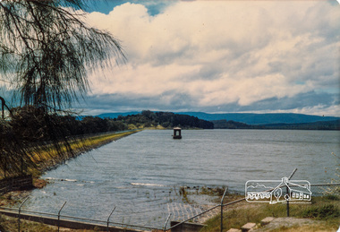
 Eltham District Historical Society Inc
Photograph, Yan Yean, 1987, 1987
Originally contained in a 'magnetic' photo album of scenic photos of Yan Yean and Warrandyte believed to be donated by Mrs Eric Stephenson, Jingalong, 110 Ryans Road, Eltham, Vic. 3095; relocated to archival safe storage. On the 20th December 1853 Lieut Governor Charles LaTrobe took his spade to turn the first sod of an embankment across the swampy bed of the Plenty River at a lonely place called Yan Yean, in order to create Melbourne’s first water supply. In the early 1850’s water had been drawn from the Yarra which even then was known as Yarra Soup. A convict by the name of James Blackburn produced the basic design for supplying water to Melbourne from a reservoir on the Plenty River at Yan Yean, and later on he was appointed consulting engineer on the project. In 1853 a contract was let for the building of the wall for 91 thousand 575 pounds, and at one stage some 400 labourers were at work in the area. A tramway was constructed to convey stone and other materials from Melbourne. So famous was this magnificent stretch of water that illustrations of the bluestone embankment and tower appeared in London journals Whittlesea Historical Society – Historic items for Diamond Valley Community Radio September 1990 Colour photographyan yean, yan yean reservoir -
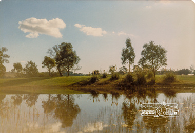
 Eltham District Historical Society Inc
Photograph, Yan Yean, 1987, 1987
Originally contained in a 'magnetic' photo album of scenic photos of Yan Yean and Warrandyte believed to be donated by Mrs Eric Stephenson, Jingalong, 110 Ryans Road, Eltham, Vic. 3095; relocated to archival safe storage. On the 20th December 1853 Lieut Governor Charles LaTrobe took his spade to turn the first sod of an embankment across the swampy bed of the Plenty River at a lonely place called Yan Yean, in order to create Melbourne’s first water supply. In the early 1850’s water had been drawn from the Yarra which even then was known as Yarra Soup. A convict by the name of James Blackburn produced the basic design for supplying water to Melbourne from a reservoir on the Plenty River at Yan Yean, and later on he was appointed consulting engineer on the project. In 1853 a contract was let for the building of the wall for 91 thousand 575 pounds, and at one stage some 400 labourers were at work in the area. A tramway was constructed to convey stone and other materials from Melbourne. So famous was this magnificent stretch of water that illustrations of the bluestone embankment and tower appeared in London journals Whittlesea Historical Society – Historic items for Diamond Valley Community Radio September 1990 Colour photographyan yean, yan yean reservoir -
 Eltham District Historical Society Inc
Photograph, Yan Yean, 1987, 1987
Originally contained in a 'magnetic' photo album of scenic photos of Yan Yean and Warrandyte believed to be donated by Mrs Eric Stephenson, Jingalong, 110 Ryans Road, Eltham, Vic. 3095; relocated to archival safe storage. On the 20th December 1853 Lieut Governor Charles LaTrobe took his spade to turn the first sod of an embankment across the swampy bed of the Plenty River at a lonely place called Yan Yean, in order to create Melbourne’s first water supply. In the early 1850’s water had been drawn from the Yarra which even then was known as Yarra Soup. A convict by the name of James Blackburn produced the basic design for supplying water to Melbourne from a reservoir on the Plenty River at Yan Yean, and later on he was appointed consulting engineer on the project. In 1853 a contract was let for the building of the wall for 91 thousand 575 pounds, and at one stage some 400 labourers were at work in the area. A tramway was constructed to convey stone and other materials from Melbourne. So famous was this magnificent stretch of water that illustrations of the bluestone embankment and tower appeared in London journals Whittlesea Historical Society – Historic items for Diamond Valley Community Radio September 1990Colour photographyan yean, yan yean reservoir