Showing 273 items
matching campus map
-
 Federation University Historical Collection
Book, George Brown, Prospectors' Guide (Victoria), 1936, 1936
Brown soft covered book with pullout map showing auriferous areas of Victoria. prospecting, gold, geology, quartz reefs, indicators, ballarat indicators, miners' rights, mining leases, forest regulations, equipment, gold cradle, puddling machine, sluice box, whim, whip, california pump, cradle, mining, tools, mining laws -
 Federation University Historical Collection
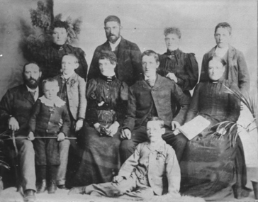
Photograph - Photograph and Documents, Anne Beggs Sunter, Latta/Downing Family, Mount Helen
The Federation University Mt Helen Campus was once the farm of John Latta and his wife Elizabeth Ann Dean. The couple married in 1867 and had three children at the time of John Latta's death (Elizabeth Ann b.1870; Mary b.1873; John b.1875). Elizabeth later married George Downing, and had another six children. The house was situated in the vicinity of the current Administration and Caro Conference Centre buildings, surrounded by an orchard, and a well under the current Albert Coates Building (Union Building). The land was purchased by the Ballarat School of Mines for their tertiary division from the Stapleton family.Various items relating to the Federation University Mount Helen Campus, and the early settlers on the land, the Latta Family. .1) Parish Plan, including E. Latta, M. Fiscalini, R. Wynne, R. Nixon, J.U. Smith, J. Davis .2) Part of a 1930s ordinance map showing Ballarat, Buninyong and Greenhill .3) Contour Map with the first two Mt Helen Campus buildings included. .4) Drawing a a proposed campus plan .5) Latta Family negativemount helen campus, latta family, greenhill, e. latta, m. fiscalini, r. wynne, r. nixon, j.u. smith, j. davis, parish plan, john latta, elizabeth latta, george downing, elezabeth downing, green hill, pontresina, abraham baxter, g. dean, market gardens, jim downing, bob thornton, j. hateley, martin fanning, toll keeper, anne beggs sunter -
 Federation University Historical Collection
Book, The Old Pioneers' Memorial History of Melbourne From the Discovery of Port Phillip to the World War, 1924
Blue hard covered book of 494 pages. Images, and a large plan of prominent burials in the Melbourne Old Cemetery, and a Map of Melbourne. melbourne, melbourne cemetery, melbourne old cemetery, john batman, edmund hobson, batman's map, st francis' church, james balfour, mrs hornbrook, paddy's market, wilson hall, working men's college, henry kendall, le souef's cottage, world war one, westernport, melbourne cup, hoddle, collingwood, south melbourne, prahran, richmond, kew, brunswick, coburg, preston, hawthorn, camberwell, nunawading, doncaster, st kilda, brighton, sandringham, cheltenham, caulfield, oalkleigh, footscray, sunshine, north melbourne, carlton, ballarat school of art library, ballarat technical art school, book plate, library plate, hume and hovell's overland journey 1824-5, major mtichell's overland journey, australia felix, booplate, aborigine, aboriginal, captain cook, arthur phillip, isaac smith, george bass, matthew flinders, john murray, catain baudain, captain collins, edward henty, portalnd, map od melbourne in 1938, john pascoe fawkner, the "enterprise: and fawkner's first home, old colonists' homes, rushall crescent north fitszroy, richard bourke, the old melbourne post offfice, old governmnt house, toorak, latrobe's house at jolimont, first melbourne land sale, melbourne water supply, peter henry smith, victorian legislative council opening, map of melbourne and collingwood, prince's bridge, crossing the rivers by punt, f.a> rucker, canvas city emerald hill, arrival of the gold escort in melbourne, the yarra, queen's wharf, tall ships, old st james, mary e. budd, st francis church, michael carr, meolbourne city mission, state library of victoria, melbourne public library, bourke street, angus mcmilan, methodist ladies college, ormond college, armistance celebrations, robert russell, mia mia, theatre royal bouke st, melbourne from flaggstaff hill, federal coffee palace collins st, lord melbourne, melbourne mint, old melbourne town hall, robert russell's melbourne and yarra falls, mandevalle hall, point lansdale lighthouse, wilson's promontory, margaret m. ward cole, williamstown, flinders st melbourne, queenscliff battery, broadmeadows soldiers' camp, embarkation of first troops on the 'ceramic', general monsash, ian hamilton, general bridges, victorian war memorial, national war memorial, st kilda pier, first melbourne cup, hoddle's grid, albert park, melbourne mechanic's institute, st kilda toll gate, munted policeman, springthorpe memorial, james bonwick, mornane's paddock, victorian railways melbourne and surburban lines, carlton gardens, thomas napier, wiliam westgarth, george augustus robinson, william lonsdale, elizabeth mary batman, peomena frances darling batman, dig tree, exhibition of 1854, exhibition of 1866, exhibition buildings, geelong harbour, jubilee lake, port campbell, warrnambool, queenscliff lightboat, batman's first house -
Federation University Historical Collection
Booklet, Little Desert National Park and Wail State Forest Proposed Management Plan, 1991, 11/1991
Grey soft covered report of 80 pages. Includes a pull out map.little desert national park, wait state forest, management plan, horsham, department of conservation and environment, rod gowans, don spence, wimmera river, threatened plants, fauna, flora, birds, mammals, wergaia, scarred trees, mounds, pest plants, pest animals, tourism and recreation, timber, grazing, conservation -
Federation University Historical Collection
Book, Business, Service & Street Directory: Ballarat, Hepburn and Golden Plains Shires, 2011, 2011
Soft covered directory with advertisments, maps, business listings and community services. The cover featurs the Ballarat Botanical Gardens.directory, street directory, business directory, ballarat, hepburn, golden plains -
Federation University Historical Collection
Book, Business, Service & Street Directory: Ballarat, Hepburn and Golden Plains Shires, 2008-9, 2008
Soft covered directory with advertisments, maps, business listings and community services. The cover featurs the Ballarat Avenue of Honour.directory, street directory, business directory, ballarat, hepburn, golden plains -
 Federation University Historical Collection
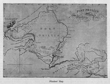
Image, Matthew Flinders' Map of Port Phillip
Scanned from "The Old Pioneers' Memorial History of Melbourne From the Discovery of Port Phillip to the World War".matthew flinders, flinders map, port phillip bay -
 Federation University Historical Collection
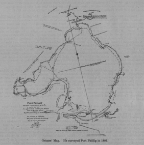
Image, Survey of Port Phillip as Mapped by Grimes
Scanned from "The Old Pioneers' Memorial History of Melbourne From the Discovery of Port Phillip to the World War".port phillip bay, grimes -
 Federation University Historical Collection
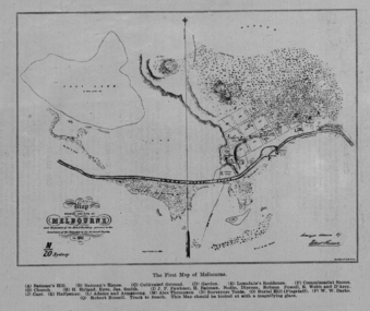
Image, The First Map of Melbourne, 1837
Scanned from "The Old Pioneers' Memorial History of Melbourne From the Discovery of Port Phillip to the World War".First map of Melbourne showing the location of Batman's Hill, Batman's House, Lonsdale's Residence, Commissarist Stores, location of John Falwkner, R. Webb, D'Acry, Carr, Diprose, Nodin, Robson, Alex Thompson, Surveyors tents, Burial Hill (AKA Flagstaff Hill)port phillip bay, batman's hill, batman's house, lonsdale's residence, commissarist stores, john fawkner, r. webb, d'acry, carr, diprose, nodin, robson, alex thompson, surveyors tents, burial hill, flagstaff hill -
 Federation University Historical Collection
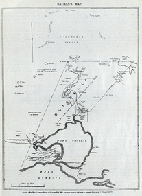
Image, Batman's Map of Port Phillip
Scanned from "The Old Pioneers' Memorial History of Melbourne From the Discovery of Port Phillip to the World War". It is a facsimile map from the House of Commons Reports of Committee.John Batman's map of Port Phillip showing Dutigalla (Batman's Tract), a township reserve, open plains, public common reserve, fresh water"A tract of country [called?] by the native chief of Southern Ausralia to be John Batman 6th June 1935."port phillip bay, john batman, melbourne, iramoo, r. sarsh, river sarsh, river batman, yarra river -
Federation University Historical Collection
Report, Report of Visit to Pumped Storage and Other Instalment in Germany, 1959, 1958
Graham Beanland is a former Principal of the Ballarat School of Mines. The report was prepared as the result of an overseas scholarshipTyped report by Graham H. Beanland. Includes original photographs, and the following sites that were visited - Geesthact, Schluchsee, Brauweiler, Rommerskirchen, Fortuna, Birsfelden, Geesthact Pumped Storage Station. A coloured map of Baden-Wurttemburg is included. graham beanland, geesthacht, schluchsee, brauweile, rommerskirchen, fortuna, birsfelden, geesthact pumped storage station, pumped storage -
 Federation University Historical Collection
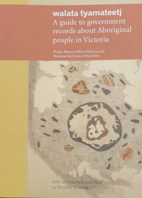
Book, Walata Tyamateetj: A guide to government records about Aboriginal people in Victoria, 2014, 2014
Ochre and yellow covered book of 87 pages with quality photgraphs of public records.non-fictionaboriginal mission stations, plan, aboringal, aborigine, aboriginal records, public record office victoria, national archives of australia, jim berg, port phillip, assimilation, chief protector of aborigines, aboriginal protectorates, board for the protection of aborigines, native police corp, edward stone parker, goulbourn river protectoratewesternport district, gunai-kurnai, coranderrk aboriginal station, lake tyers aboriginal station, antwerp primary school, wimmera river, framlingham aboriginal station, william thomas, map, charles tyers, f.p. strickland, ebernezer -
Federation University Historical Collection
Magazine, Ararat: The Guide, 2000-2001
Yellow and blue soft covered Ararat Community Directoryararat, community directory, gwenda allgood, paul hooper, pat mcaloon, steve shannon, peter o'rorke, ted millear, geoff king, bill braithwaite, ian couper, ian manley, annette newton, lesley harvie, j ward, david hawker, dianne hadden, bruce chamberaine, joe helper, john mcquilten, denis napthine, roger hallam, ararat advertiser, ararat community college, ararat map, grampians soaring club, ararat gaol, ararat town hall, gum san museum, chinese -
 Federation University Historical Collection
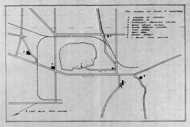
Plan, School of Mines and Industries: Location of buildings, Ballarat
Printed map showing Ballarat School of Mines locations.ballarat school of mines, plan, ballarat, lake wendouree -
 Federation University Historical Collection
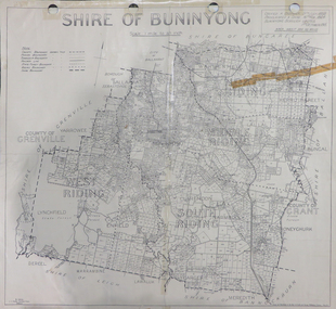
Map, Shire of Buninyong, c1970
The Shire of Buninyong was located on the southern side of Ballarat.Two maps of the Shire of Buninyong. .1) Map showing the County divisions, township boundaries, Railway line, State Forest boundary, riding boundary and shire boundary. Identifying words have been added in red and green texta. .2) Shire of Buninyong Parish Plan. Includes Buninyong, Clarendon, Narmbool, Enfield, Lychfield, SCotchman's, Navigators, Warrenheip, Scotsburn, mr Doran, Durham Lead, Cambrian Hill, Napoleons, Garibaldi, Mt Clear, Lal Lal, Bonshaw.1) B.I.A.E., St Martin's, cemetery, mt Buninyong, mt Innes, rly stn shire of buninyong, buninyong, clarendon, narmbool, enfield, lychfield, scotchman's, navigators, warrenheip, scotsburn, mt doran, durham lead, cambrian hill, napoleons, garibaldi, mt clear, lal lal, bonshaw, state forest, elaine, elaine north, cargerie, grenville, mt mercer, millbrook, wallace, yendon, canadian, kaolin deposits, mount helen campus -
 Federation University Historical Collection
Booklet, Northern Territory ... The Tanami Gold Country with Plans, 1909, 1909
Pink foolscap report of 12 pages, includes geological map from Pine Creel to Sturt's Creek by H.Y. L. brown; geological map between Mucka and Gordon Downs Station and Tanami by W.R. Murray; geological map of Tanami and surrounding country by W.R. Murray, and Plan of Lawne's Gold Prospecting Claim at Tanami by W.R. Murray pine creek, sturt's creek, tanami, northern territory, tanami gold country -
Federation University Historical Collection
Booklet - Handbook, School of Mines and Industries Ballarat - TAFE training that works, 1996/1997
Booklet with information for prospective students regarding courses available, entry requirements, employment opportunities, duration and mode of study, and how to apply as well as fee information, maps, information to help you study etc. .1 - 1996 .2 - 1997tafe training that works, ballarat school of mines and industries, ballarat school of mines, prospective students, fees and charges, entry requirements, how to apply, courses -
Federation University Historical Collection
Booklet, Buninyong Heritage Walks and other Interesting Cycle Rides and Scenic Drives, 2008
Blue soft covered book, with maps, plans and photographs relating to Buninyong, Victoria. buninyong, de soza park, buninyong tannery, buninyong railway station, eagle hotel, old buninyong library, hastie's hill, buninyong town hall, hastie's spring, crown hotel, buninyong post office, bowen tree, aborigines, buninyong primary school, buninyong cemetery, gold monument, mount buninyong, lal lal falls -
 Federation University Historical Collection
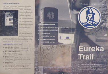
Brochure, Eureka Trail, c2000
The brochure gives information on the Eureka Stockade which took place on 03 December 1854. The Eureka trail aimed at enhancing the Eureka experience and was developed in 1996. It was managed by the City of Ballarat with funding assistance form the State and Federal governments. Much of the work was undertaken under the New Work Opportunity Programme.Blue and white brochure highlighting relevant Eureka Stockade site. The brochure includes a map showing the route the Government forces took on their way to the Eureka Stockade as well as sites of interest to Eureka which are marked by blue bollards. The brochure was presented by the City of Ballarat and the Eureka Stockade centre.eureka, eureka stockade, diggers' trail, trooper's trail, eureka stockade centre, city of ballarat -
 Federation University Historical Collection
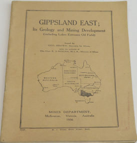
Book, Gippsland east: its geology & mining development, 1936
Soft brown covered book of 45 pages about East Gippsland mining and development. Includes map of Gippsland East, Lakes Entrance. Includes Lakes Entrance, Metung, Beng Worden, Bairnsdale, Longford, Torquay.gippsland east, gippsland, geology, mining, mines department, geo. brown, e.j. hogan -
 Federation University Historical Collection
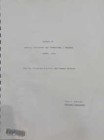
Booklet, Report of Natural Resources and Operations 1 Seminar April, 1983, 1983
This report details the program of a Natural Resources and Operations Seminar for the Victorian T.A.F.E. Off-Campus Network, hosted by the Victorian School of Forestry in Creswick. Thirty-one participants were in attendance. The program was conducted from the 6th to the 8th of April, 1983 and excursions were made to the You Yangs Forest Park, the Serendip Wildlife Research Station and Werribee Gorge National Park.A ring bound booklet of 19 pages and clear laminate covers. Includes a map of the Victorian School of Forestry, Creswick.natural resources, seminar, school of mines ballarat, ballarat school of mines, victorian t.a.f.e off-campus network, school of forestry, creswick, victorian school of forestry -
Federation University Historical Collection
Booklet, Ballarat School of Mines Botanical Gardens Conservation/Restoration Management Plan
A Conservation/Restoration Management Plan for the Ballarat School of Mines Botanical Gardens. The report includes a planting timeline of the plants included in the gardens from 1850. Historical plans and maps are detailed from 1857 up to the site assessment in 2008.Printed report stapled at top left corner.Lisa Palmer written at top right corner in pencil.smb, school of mines ballarat, ballarat school of mines, botanical gardens, smb botanical gardens, conservation, restoration, ballarat school of mines garden, von mueller garden, ferdinand von mueller, botany, living collections, horticulture, gardens -
 Federation University Historical Collection
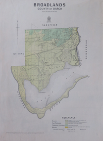
Map, Broadlands, County of Dargo, 1887
Plan of Broadlands, County of Dargo, Victoria.broadford, j.g. easton, dargo, geological -
 Federation University Historical Collection
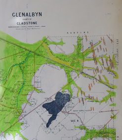
Map, Glenalbyn, County of Gladstone
Copy of a geological map of Glenalbyn. Some areas have been colours green. Creeks have been coloured blue, roads and reefs have been coloured orange.glenalbyn, county of gladstone, tarnagulla, inglewood, kingower, kurting, old inglewood deep lead, salisbury west -
 Federation University Historical Collection
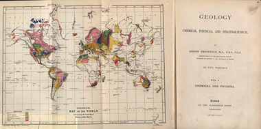
Book, Geology, Chemical, Physical, and Stratigraphical, 1886
These books were added to the library of the School of Mines Ballaarat in 1889. The author was Joseph Prestwich, who was a Professor of Geology at the University of Oxford.Two brown hard cloth covered books, Vol 1 & vol 2 with gold printing on the front cover and on the spine. .1) has a coloured fold out map of the World opposite the title page .20 has a coloured fold out map of Europe..1) A label is attached to the inside front cover with The School of Mines Ballaarat and the no. 955 and date purchased 14/3/89 (1889) as well as the institutions stamp in several places throughout the book. .2) As above but with no. 956 and on the inside fly is written in pencil 'Stamped in Error' with a Ballarat School of Mines Student Library stamp crossed out.geology, bookplate, library plate, ballarat school of mines library, joseph prestwich, geological map of the world, geological map of europe, hieropolis thermal springs, rockss, ice, volvanoes, earthquakes, metallurgy, shakespeare's cliff dover, wapley, gloucestershire, redruth mining district, fossils, reptilian footprints, chalk, london clay -
 Federation University Historical Collection
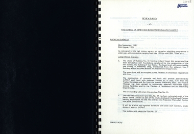
Report, SMB: Review Survey of Buildings and Grounds, July 1985, 1985
Report of the detailed review of The School of Mines and Industries Ballarat Limited undertaken by Alexander & Alexander in 1985. Previous reports were done in 1982 and 1983. The report covers all areas of the school - buildings and grounds. Some sections/buildings are still being completed. Report contains written evaluation, maps/diagrams and photographs.Spiral bound book - dark blue cover. 15 pages of written information plus 3 pages of photographs.Gold lettering on from cover "Alexander & Alexander" Signature "J W Elliott" on page 10 (Loss Control Surveyorballarat school of mines and industries, survey, alexander and alexander, j w elliott, maps, photographs -
 Federation University Historical Collection
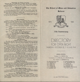
Programme, School of Mines: 75th Anniversary, Directory for Open Night, 1945, 1945
To celebrate the 75th Anniversary of the School of Mines and Industries an Open Night was held on Thursday, October 25 (1945) from 7 to 9.15 p.m. The Principal was Mr A Heseltine and the Registrar was Mr F Ferguson. Members of the School Council included E J Tippett, M G Beanland who have a building or walkway named after them. A map of the buildings shows the various areas and information is given for each department. Though it was an Open Night it would also serve as an Information Night for student enrolling for the following year.Paper folded in half and printed on each of the four sections. Map showing layout of buildings. Information on each department of the school.ballarat school of mines and industries, 75 anniversary, a heseltine, principal, f e ferguson, registrar, e j tippett, m g beanland, open night, information night -
 Federation University Historical Collection
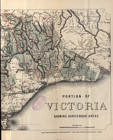
Map - Map and Information, Department of Mines: Map and Suggestions to Prospectors, 1891
The map outlines the auriferous (gold bearing) areas in Victoria. The information for prospectors was prepared by the Department of Mines in 1894Document: 4 page type written Map: Portion of Victoria divided into Counties of 1891. Auriferous areas with red.Reference section on mapgold, auriferous areas, department of mines, victoria, map of victoria, prospectors, commissioner of crown lands, hon a mclean, alexander black, surveyor general, a mclean -
 NMIT (Northern Melbourne Institute of TAFE)
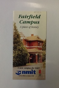
Brochure - NMIT Fairfield campus, Fairfield Campus: a piece of history, 2001
... contains information on the 'new' NMIT campus at Fairfield, opened ...This brochure contains information on the 'new' NMIT campus at Fairfield, opened in 2001. It includes details of proposed courses and information about how to reach the campus.Tri-fold brochure with text, colour illustrations and map. fairfield, fairfield campus, nmit, -
University of Melbourne, Burnley Campus Archives
Book, Olive Mellor, Complete Australian Gardener Illustrated, 1950
Olive Mellor was a past student and staff member at Burnley College.304 p., [1] leaf of col. plates : ill., map, plans ; 24 cm.olive mellor (nee holttum), staff, female students, gardening, australia