Showing 1713 items
matching counties
-
 Bendigo Historical Society Inc.
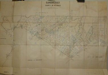
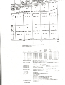
Map - JACK FLYNN COLLECTION: SANDHURST SHEET 1, January 1947
Map: Parish of Sandhurst sheet 1, County of Bendigo. Parish plan.map, bendigo, parish plan, sandhurst -
 Bendigo Historical Society Inc.
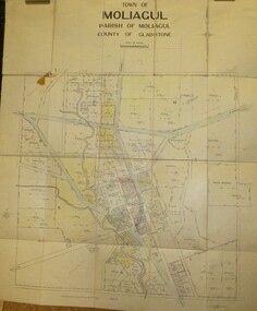
Map - JACK FLYNN COLLECTION: MOLIAGUL, 7/02/1931
Map: Township of Moliagul, Parish of Moliagul, County of Gladstone. Parish plan.map, gladstone, township, moliagul -
 Bendigo Historical Society Inc.
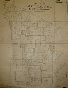
Map - JACK FLYNN COLLECTION: MOLIAGUL, October 1946
Map: Parish of Moliagul, Sheet 1, County of Gladstone. Parish plan.map, gladstone, parish plan, moliagul -
 Bendigo Historical Society Inc.
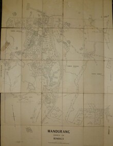
Map - JACK FLYNN COLLECTION: MANDURANG SHEET 2, March 1947
Map: Parish of Mandurang, Sheet 2, County of Bendigo. Parish plan.By Authority J.J.Gourley Government Printer Melbourne. Drawn and Produced at the Dept, of Lands and SurveyMelbourne, Victoria. March 1947.map, bendigo, parish plan, mandurang -
 Bendigo Historical Society Inc.
Map - JACK FLYNN COLLECTION: GIRGARRE, 1957
Map: Township of Girgarre, Parish of Kyabram, County of Rodney. Parish plan.By Authority: W. M. Houston, Government Printer, Melbourne. Drawn and reproduced at the Department of Lands and Survey, Melbourne.map, rodney, township, girgarre -
 Bendigo Historical Society Inc.
Map - JACK FLYNN COLLECTION: BET BET, 18/08/1931
Map: Parish of Bet Bet, Counties of Gladstone and Talbot . Parish plan.By Authority H.J. Green Govt, Printer. Photo Lithographed at the Department of Lands and Survey, Melbourne. 18.8.31map, gladstone, parish plan, bet bet, counties of gladstone and talbot. -
 Bendigo Historical Society Inc.
Map - JACK FLYNN COLLECTION: GOORNONG, August 1953
Map: Township of Goornong, Parish of Goornong, County of Bendigo. Parish plan.By Authority W.M. Houston. Government Printer. Drawn and Reproduced at the Dept., of Lands and Survey, Melbourne, Victoria. August 1953map, bendigo, township, goornong -
 Whitehorse Historical Society Inc.
Document, Plan of Blackburn, 1886
Crown grants, Parish of Nunawading, County of Bourke,Crown grants, Parish of Nunawading, County of Bourke, covers the Blackburn area.Crown grants, Parish of Nunawading, County of Bourke,woods, john, purches, edwin james, coppin, george seth, parish of nunawading, county of bourke, blackburn, tranter, william, orr, joseph, whitman, frank -
 Bendigo Historical Society Inc.
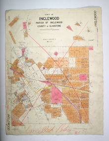
Map - TOWN OF INGLEWOOD, March 1946
Map: Town of Inglewood, Parish of Inglewood, County of Gladstone. Parish planmap, gladstone, township, inglewood -
 Bendigo Historical Society Inc.
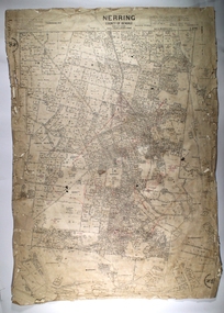
Map - NERRING, 25/08/1903 ?
Map: Parish of Nerring, County of Bendigo. Parish plan Canvas backedmap, bendigo, rural, nerring, county of bendigo -
 Clunes Museum
Plan - TITLE PLAN, DEPARTMENT OF LANDS AND SURVEY, TOWNSHIP OF GLENGOWER
1 PAGE PLAN OF THE TOWNSHIP OF GLENGOWER COUNTY OF TALBOT (11 COPIES) DRAWN AND REPRODUCED AT THE DEPT. OF LANDS AND SURVERY MELBOURNE VICTORIA NOVEMBER 1954 PRICE 2/-parish of glengower, title plan of glengower -
 Warrnambool and District Historical Society Inc.
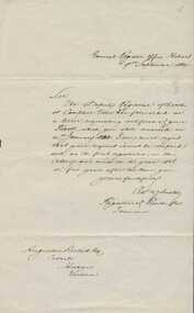
000851.1; Letter 000851.2:Copy of Baptismal entry, Augustus Bostock birth details, 000851.1. 1884. 000851.2 late 20th century
Augustus Bostock was the 9th child of Robert & Rachael Bostock of Vaucluse Epping Forest, Van Diemen’s Land. He was only 4 years old when his mother died. He was inspired by his father to seek his fortune in the Western District of Victoria. He arrived around 1850. He married Margaret Aitkin in July 1865. Augustus owned several properties in the district and leased others. He sat on the court of Warrnambool, Mortlake or Hexham as required. He resided at Marramook in Hawkesdale and later moved to Vaucluse in Hopetoun Road Warrnambool, where he died in 1920 at the age of 87. He was involved in many aspects of life in the Western District, racing, cricket, and social activities to name a few. These two documents relate to the registration of Augustus Bostock’s birth 14/01/1833. This is one of a number of documents which relate to the Bostock family who were one of the most important pioneering families of the Western District. They owned and leased various properties around Warrnambool and were involved in many aspects of social and business life. This is a personal document which confirms details of the birth of Augustus Bostock.000851.1. Handwritten letter from General Register Office Hobart. Foolscap sized lined white paper with writing in black ink. 000851.2 Copy of baptisms in the parish of Campbelltown 1835. Handwritten entries in chart form with handwritten entries. 000851.1 General Register Office Hobart. 000851.2 Parish of Campbelltown in the county of Cornwall 1835. warrnambool, augustus bostock, robert and rachael bostock, campbelltown, hobart 1835. -
 City of Moorabbin Historical Society (Operating the Box Cottage Museum)
Photograph - Map of Dendy's Special Survey, 1852 Map of Henry Dendy's Special Survey of 1841, 19th Century
A Map drawn in 1852 that shows the 5,120 acres that formed Dendy's Special Survey of 1841. In 1840 Henry Dendy, a farmer in Surrey, England acquired a "Special Survey" from the Commissioners for Land and Emigration which gave Dendy the right to choose land in Port Phillip for the "bargain basement" price of only £1 per acre for 5120 acres, (an area of 8 square miles). The Special Survey also included the right to "the shipment of a worker for every £20 spent on land, whose free passage was paid by the Crown, equalling a total of 100 workers ". Accordingly Dendy sold his English holdings and paid the required £5120 and arrived in Melbourne in February 1841. However by this time land in the new colony was selling for £5 - £40 per acre. Because Henry Dendy possessed the order from the Colonial Office in London he was able to successfully oppose Governor LaTrobe's attempts to alter the price of the land. Dendy appointed Jonathan Were, (an entrepreneur, who had arrived in 1839), as his Manager and who later became a partner. Together, Dendy and Were decided on an area 5 miles south from Melbourne, bounded by North Road, East Boundary Road, South Road and to the west by Port Phillip Bay. Were and Dendy pitched their tents in the area now known as ' Park St, Brighton' and sank a well near the corner of 'St Andrew's St and Wells St'. By 1845 J.B Were and Company had bought almost half of Dendy's land and Were built himself "Moorabbin House" in Were St Brighton made from stone, quarried from local cliffs. It was still standing in 1924. Legend records Moorabbin is named after the Aboriginal word for ' Mother's Milk ' The soil is very fertile and well supplied with water especially in the area called 'East Brighton' - now known as Bentleigh and East Bentleigh - By 1850 the area had developed with numerous market gardens, dairy farms, fruit gardens and vineyards supplying food for the growing population of Melbourne.This Map shows the birth of the Brighton and Moorabbin area. On 18th January1859 Brighton was proclaimed a Municipality and a Borough by October 1863. Meanwhile, following a Petition, the area of East and South Brighton, incorporating Mordialloc, Cheltenham, Mentone, Sandringham and Oakleigh separated from Brighton to form the Moorabbin District Roads Board becoming the first Local Government Authority. Col. William Mair was elected as the first Chairman of the Moorabbin Roads Board. Moorabbin Shire 1871 developed further and was declared a City in1934. The City of Moorabbin was the largest Municipality in Melbourne before the Amalgamation of Councils in 1994 when it was divided in the south to City of Kingston and in the north to City of Glen Eira A Photo-lithographed 1852 Map showing the 5,120 acres that formed Dendy's Special Survey of 1841. Henry Dendy & Jonathan Were chose an area 5 miles south from Melbourne, bounded by North Road, East Boundary Road, South Road and to the west by Port Phillip Bay. Moorabbin County of Bourke / Photo-Lithographed at the department of Lands and Survey. /Melbourne. / Price 1/- brighton, moorabbin, bentleigh, cheltenham, dendy henry, bent thomas, were jonathan, special survey -
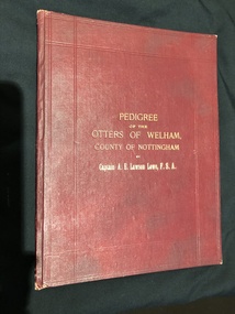 Mont De Lancey
Family Tree Pedigree, Mitchell and Hughes, Printers, Circa 1880 - MDCCCLXXX
Compiled by Captain A.E. Lawson Lowe, F..S.A. containing a detailed family tree of the Otter family from 1557 to around 1895, including Colonel Otter.Burgundy hardcover booklet with gold inscription on cover, containing Pedigree of the Otters of Welham.Cover: "PEDIGREE Of The OTTERS OF WELHAM, COUNTY OF NOTTINGHAM By Captain A.E. Lawson Lowe, F.S.A."genealogical documents -
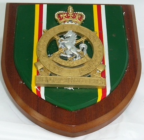 4th/19th Prince of Wales's Light Horse Regiment Unit History Room
Plaque - Kent & County of London Yeomanry
Wooden shield shaped plaque with badge of Kent & County of London Yeomanry affixedplaque, kent & county of london yeomanry, kent & county of london yeomanry -
 Bendigo Historical Society Inc.
Map - JACK FLYNN COLLECTION: TARNAGULLA SHEET 4, 25/11/1926
Map: Parish of Tarnagulla Sheet 4, Counties of Gladstone and Bendigo. Parish plan.Photo-Lithographed at the Department of lands and Survey, Melbourne by W. J. Butson. 25.11.26map, gladstone, parish plan, tarnagulla sheet 4 -
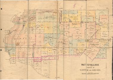 Bendigo Historical Society Inc.
Map - JACK FLYNN COLLECTION: NATTE YALLOCK, 22/06/1937
Map: Parish of Natte Yallock, Counties of Gladstone and Kara Kara. Parish plan.By Authority H.J. Green Government Printer Melbourne. Drawn and Reproduced at the Depart., of Lands and Survey, Melbourne, Victoria.map, gladstone, parish plan, natte yallock -
 Bendigo Historical Society Inc.
Map - JACK FLYNN COLLECTION: LAANACOORIE, No date visible
Map: Parish of Laanacoorie, County of Bendigo. Parish plan. Half of the sheet is missing.By Authority H.J. Green. Govt, Printer.map, bendigo, parish plan, laanacoorie -
 Bendigo Historical Society Inc.
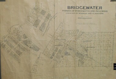
Map - JACK FLYNN COLLECTION: BRIDGEWATER, 10/09/1931
Map: Bridgewater, Parishes of Bridgewater and Inglewood, Counties of Bendigo and Gladstone. Parish plan.map, bendigo, parish plan, bridgewater inglewood -
 National Vietnam Veterans Museum (NVVM)
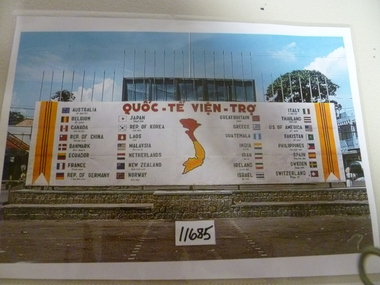
Photograph, Quoc-Te Vien-Tro
Coloured photograph of Quoc-Te Vien-Tro displaying 30 counties and their flagsphotograph, flag -
Whitehorse Historical Society Inc.
Map, Parish of Nunawading, 1970
[Parish of] Nunawading, County of Bourke. Government Printer Showing original land owners.parish of nunawading, maps, land settlement -
 Bendigo Historical Society Inc.
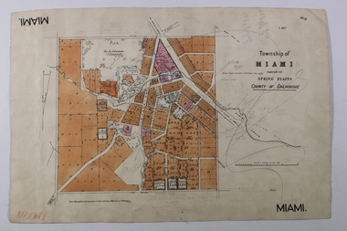
Map - MIAMI ( MIA MIA), 26/06/1906
The name Miami on the is a misprint Map: Township of Miami (Mia Mia), Parish of Spring Plains, County of Dalhousiemap, dalhousie, township, mia mia, spring plains creek -
 Halls Gap & Grampians Historical Society
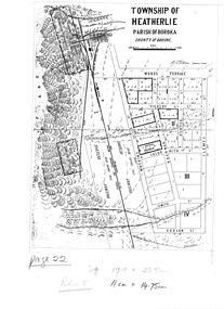
Map - Photocopy
Photocopy of map of Heatherlie TownshipTownship of Heatherlie; Parish of Boroka; County of Borung; scale measurement; R.O. Robson Authorised Surveyormaps, heatherlie township -
 Halls Gap & Grampians Historical Society
Map - Coloured
Map showing layout for township of HeatherlieTownship of Heatherlie; Parish of Boroka; County of Borung; scale measurement; R.O. Robson Authorised surveyormaps, heatherlie township -
 City of Moorabbin Historical Society (Operating the Box Cottage Museum)
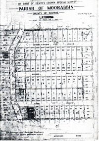
Flyer - Garfield Estate, Ormond
At the end of World War One, there was a renewed interest in residential land and a number of estates opened up in the Municipality of Moorabbin.Example of the progress of the Municipality of MoorabbinPhotocopy of the plan of the Garfield Estate, OrmondPart f Dendy's Crown Special Survey - parish of Moorabbin - County of Bourke - Garfield Estatedraper street, lord street, hudson street, blackshaw street, tucker road, ormond, mckinnon, real estate -
Clunes Museum
Map - MAPS/ DOCUMENTS, CIRCA 1857
COLLECTION OF DOCUMENTS (COPIES OF10 MAPS AND DIAGRAMS OF TOURAAL PURCHASED UNDER PREEMPTIVE RIGHT BY DONALD CAMEROM 17TH FEBRUARY, 1857. COUNTY OF TALBOT - GOLDFIELD'S SURVEY PLAN NO.1 CLUNES COUNTY OF TALBOT. GLENDONALD - CRESWICK/CLUNES.local history, mining -
 Federation University Historical Collection
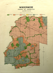
Map, Windermere, County of Grenville
Coloured geological map of Windermere, County of Grenville. Scale is 40 chains to 1 inchwindermere, grenville, krause, plan, map -
 Federation University Historical Collection
Postcards - black and white, Souvenir of Enniskerry, County Wicklow, Eire
Black and white photographic postcard showing three images of Enniskerry, County Wicklow, Eirechatham family archive, enniserry, eire, wicklow, powerscoirt, sugarloaf -
 Federation University Historical Collection
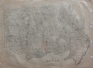
Maps, County of Lowan, 1930
Printed maps on paper backed onto linen: .1) County of Lowan .2) Weeahlowan -
 Bendigo Historical Society Inc.
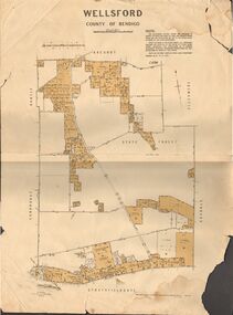
Map - JACK FLYNN COLLECTION: WELLSFORD, 15/12/1941
Map: Parish of Wellsford, County of Bendigo. Parish plan. 2 copies of the same plan.map, bendigo, parish plan, wellsford