Showing 289 items matching "david small"
-
 Coal Creek Community Park & Museum
Book, Mac Millan and CO. Limited, Elementary Lessons in Electricity and Magnetism by Silvanus Thompson, 1907
... Korumburra gippsland Christmas 1907 David Martin 8138.1 - Small red ...8138.1 - Small red hardcovered book titled Elementary Lessons in Electricity and Magnetism by Silvanus Thompson.Christmas 1907 David Martin -
 Bendigo Historical Society Inc.
Document - ERROL BOVAIRD COLLECTION: LONDON COLLEGE OF MUSIC CERTIFICATE
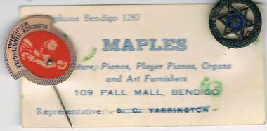
Small card issued by maples of pall Mall Bendigo. Small ornamental circle featuring Star of David in centre, andf lapel pin in the name of Florence Nightingale Memorial. -
 Bendigo Historical Society Inc.
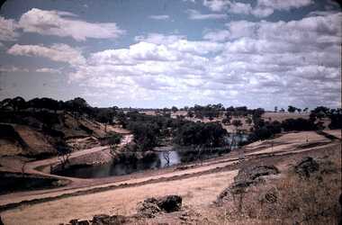
Slide - DAVID MCDONALD COLLECTION: EPPALOCK. CONSTRUCTION, c1961
Eppalock. Construction. Shows the base of Eppalock with a small amount of water in it. No equipment in sight. Markings: Eppalock Dam 1961.Agfacolorcivil engineering, water supply, eppalock -
 Bendigo Historical Society Inc.
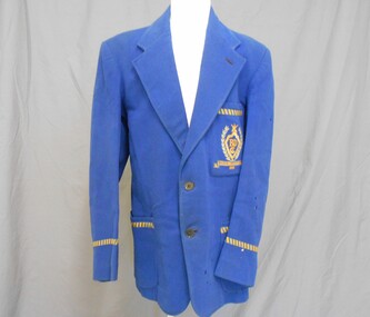
Clothing - BLAZER BENDIGO CRICKET CLUB, 1952
Clothing. Royal blue woollen fabric, with revere pointed collar and lapels. Left lapel has one stitched button hole. Breast pocket - depth 17.5 cm, width 14 cms embroidered in light blue, royal blue and gold, a coat of arms with laurel wreath cricket stumps, ball and two cricket bats. Within a shield shape is embroidered BDCA-possibly Bendigo and District Cricket Association. Below the shield shape is an embroidered ''ribbon'' embroidered with PROVINCIAL PREMIERS VCCL 1952, 1.5 cm braid-royal blue and gold trims the sleeves above the cuff.One small internal pocket in left front.All internal seams are bound in black tape. Shoulders of the blazer are lined with black polished cotton type fabric. Sleeves are lined with cream cotton fabric, with fine stripes of blue and brown. Two stitched button holes and two black plastic buttons.Label inside back collar: David Lack Pty Ltd Melbourne & Sydney. Label stitched inside back shouderline: Blazer and Uniform Specialists David Lack Pty Ltd Melbourne , Sydney. NAME….No…costume, male, blazer - bendigo cricket club -
 NMIT (Northern Melbourne Institute of TAFE)
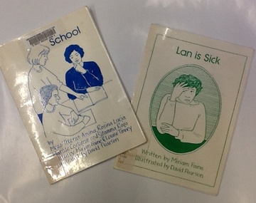
Book - NMCOT, School; and, Lan is Sick: edited by Miriam Faine for the Migrant Women's Language Centre, NMCOT, Circa 1990s
Two small books written or edited by Miriam Faine and illustrated by David Pearson. Produced by Migrant Women's Language Centre, NMCOT, with support from Victorian International Literacy Year Secretariat. The book "School" relates the experiences of four women from various cultures.2 books, 12 and 16 pages. Hand drawn illustartions.Both books are stamped withNMCOT Library Network stamps.english as a second language, literacy, migrant women's language centre, nmcot, nmit, -
National Vietnam Veterans Museum (NVVM)
Memorabilia, Memorabilia of David Edgley
Memorabilia of David Edgley consisting of 9 copies of hand drawn, purple coloured, humourous cartoons depicting soldiers during in the Vietnam War & also a small cartoon of a Vietnamese soldier with the text written in Vietnamese.cartoon, vietnam war - 1961-1975 - soldiers - australian -
 Geelong Cycling Club
Wooden Shield, 1967
Shield prepared to recognise winners of a Geelong West Cycling Club road race in memory of Russell Wright.This perpetual trophy spans 3 decades on road racing with the GWCC.Wooden shield with small shield shapes in plated silver placed around the shield. These small plaques are inscribed with winners of this event. The shield also has a plated silver banner with inscriptions on it, plus the shape of a cyclist in a medallion at the bottom of the shield."Geelong West Cycling Club/Russell Wright Memorial Shield/ Donated by his Loving Wife/1967 R Dillon 68m59sec/1968 J Elsworthy 54mins 55secs/ 1969 T Ryan 70mins 3secs/ 1970 R Edwards 53mins26secs/1971 Geo O'Dwyer 82mins 17secs/1972 K Bunting 51min 50 secs/1973 W Mahoney 54min 20secs/ 1974 W Crookshanks 83min 28secs/ D Ferguson 83 mins 47 secs/ 1976 S Jennings/ 1977 R Bunting 51mins 50 secs/ 1978 - /1979 Don Wilson/1980 Rodney Baker/ 1981 David Carnegie/ 1982 -/ 1983 Neville Williams/ 1984 Tony Pickles/ 1988 Ian Hendry"geelong west cycling club; gwcc; russell wright memorial shield; 1967; r dillon; 1968; j elsworthy; 1969; t ryan; 1970; r edwards; 1971; george o'dwyer; 1972; k bunting; 1973; w mahoney; 1974; w crookshanks; d ferguson; 1976; s jennings; 1977; r bunting; 1978; 1979; don wilson; 1980; rodney baker; 1981; david carnegie; 1982; 1983; neville williams; 1984; tony pickles; 1988; ian hendry; -
 Tatura Irrigation & Wartime Camps Museum
Magazine, After the Battle, 2009
Periodical featuring, amongst others, an article on Camp 13, at Murchison. Written by David Mitchel-Hill, a POW Camp No 13 at Murchison, pages 28 - 49.Soft cover, rural scene featuring a horse, cactus plant, hills and trees on the front cover. A small picture of an army tank on the front cover and memorial scene on the back cover. Red, black and white text.camp 13 murchison, david mitchellhill-green, after the battle, camp 13, murchison camp, pow camp murchison -
Tatura Irrigation & Wartime Camps Museum
Album - small photo album
The artist of the sketches Hans - Wolter von Gruenewaldt - ex South African Mining Engineer served in the North Africa campaign. This album also includes photos of visitors to the Tatura Museum, Memorial service German War Cemetery 1992 and visitors to Camps 1, 2, 4 and 13 Photos include Murchison R.S.L clubhouse,which was Murchison P.O.W Camp,13 Recreation Hall, Colonel Walter Tinsley D.S.O who was appointed Commandant camp 13 1946, Folk Dancers from Hungary,Scotland, Yugoslavia, Russia, Spain, Holland, German waitress, African Mother and Child,, Asia, Australian swagman, Australian A.W.A.S, British Army W.O, British Naval Officer. Visitors to Memorial service German War Cemetery 1992 Photos show a collection of the art work painted on walls of Camp 13 Recreation hall Small, green coloured photo albumHans-Wolter von Gruenewaldt, German P.O.W. painted these scenes and figures as murals on the walls of the camp 13 Recreation Hall. The hall was transferred to Murchison after WW2 and was purchased by the Murchison R.S.L. as its headquarters in 1955. These paintings can now be seen at the David Jones Nursing Home in Murchison.murchison pow recreation hall, german war cemetery -
Tatura Irrigation & Wartime Camps Museum
Photographs, 2001
Hans - Wolter von Gruenewaldt, German P.O.W (Ex South African - Mining engineer) painted these scenes and figures as murals on the walls of the Camp 13 Recreational hall. After WW2 the hall was purchased by the Murchison R.S.L as its headquarters in 1955. These paintings can now be seen at the David Jones Nursing Home in Murchison.Small photo album, with a collection of painted scenes and figures as murals on the walls of camp 13 Recreational hall. The album also includes photos of visitors to the Internment camps, Japanese Chan, Oki and Takamura families at the Tatura Historical Society, and visitors to the German War Cemetery during 1992/93. -
Melbourne Athenaeum Archives
A3- size,small poster, Reader’s Theatre – Literary Seasons,a variiety of imporartant literary peices present my varuous individuals in ascoiation with reader's feast at the melbourne Athenaeumv theatre 4 August 2016, 2016
Produced by Reader's Feast (Book shop) -actors –Don Bridges, Suzy Cato-Gashler, Sue Jones and David Tredinnick)A3-size poster colouredreader's theartre, athenaeum theatre, readers feast, don bridges, suzy cato-gashler, sue jones, david tredinnick -
 Emerging Writers' Festival
2008 Festival Program, Emerging Writers' Festival 2008 Festival Program
This is the program from the 2008 Emerging Writers' Festival. The program provides information about the events and programs involved in the festival, the first EWF programmed by Artistic Director David Ryding.Small cream and grey stapled booklet containing the details of the 2008 Emerging Writers' Festival programming.2008 emerging writers' festival, david ryding, literary program, the wheeler centre, emerging writers', literary, festival, melbourne -
 Emerging Writers' Festival
2009 Festival Program, Emerging Writers' Festival 2009 Festival Program
This is the program from the 2009 Emerging Writers' Festival. The program provides information about the events and programs involved in the festival, programmed by Artistic Director David Ryding.A small black and grey program of the 2009 Emerging Writers' Festival events.2009 emerging writers' festival, david ryding, literary programming, the wheeler centre, emerging writers', literary, festival, melbourne -
 Rutherglen Historical Society
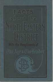
Booklet, David Syme & Co, Facts about the North Eastern District, With the Compliments of The Age & The Leader, c1928
Covers information on the districts and the leading towns of the north-east of Victoria, including Benalla, Rutherglen, Wodonga, Omeo, Euroa and Mansfield. Centre pages present statistics comparing 1928 to 1908, relating to agricultural production, and the population, dwellings and valuations of the shires of each of these towns.Small booklet with a dark blue-green cover, containing information about the North Eastern districts of Victoria.benalla, rutherglen, wodonga, omeo, euroa, mansfield, statistics -
 Rutherglen Historical Society
Photograph - Image, 1925-1935 (Approximate)
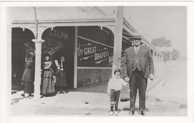
Donated by Mrs Lockwood, Bonnie, formerly HamiltonPostcard size, black & white reproduction, unframed. Norman Hamilton & small boy in front of O. Gilpin's store which once belonged to his father Mr David Hamilton"Norman Glen Hamilton, cnr High & Main Streets O. Gilpin store ex D.G. Hamilton"norman hamilton, gilpin store, d g hamilton -
 Rutherglen Historical Society
Microfiche, Corporation of the President of the of Jesus Christ of Latter Day Saints, Family Register Index, 1987
Identity the families registered with the Church of Jesus Christ of Latter Day Saintssmall sheet of film Alphabetical Index DAVID - SARAH ANN Church of Jesus Christ of Latter Day Saintsfamily, register, alphabetical -
 Rutherglen Historical Society
Microfiche, Corporation of the President of the of Jesus Christ of Latter Day Saints, Family Register Index, 1987
Identity the families registered with the Church of Jesus Christ of Latter Day Saintssmall sheet of film Alphabetical Index MARTIN - DAVID JESSEE Church of Jesus Christ of Latter Day Saintsfamily, register, alphabetical -
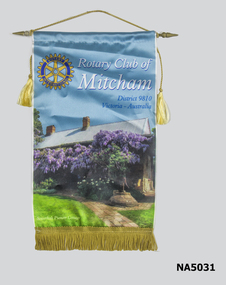 Whitehorse Historical Society Inc.
Banner - Rotary Club of Mitcham Banner
Donated by the Mitcham Rotary ClubA small banner with a coloured photo of Schwerkolt Cottage. A Rotary Club symbol on the upper left hand side. Rotary Club of Mitcham in white script. District 9810 Victoria Australia " Schwerkolt Pioneer Cottage" under photo of cottage.Screencraft David-E1 Phone 03 9899 3262service clubs, rotary club of mitcham, schwerkolt cottage, societies, screencraft -
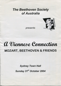 Ballarat Heritage Services
Program, The Beethoven Society of Australia, A Viennese Connection, Sunday 31st October 2004
Dr Steve Watson brings a diversity of musical experiences to the challenges of musical direction. Phil Chu - Associate Conductor. Sheila Guymer, Accompanist. Singers: Penelope Mills, Jacqueline Dark, Warren Fisher, David GrecoA4 white paper 8 pages booklet, with black writing, with a small image of Beethoven on the front coverThe Beethoven Society of Australia presents A Viennese Connection MOZAR, BEETHOVEN & FRIENDS Sydney Town Hall Sunday 31st October 2004dr steve watson, phil chu, sheila guymer, penelope mills, jacqueline dark, warren fisher, david greco -
 Wangaratta High School
OC Trophy- Sport
Small plastic trophy holding a double sided silver medal with an image of a football player on one side and the name David Spence on the other -
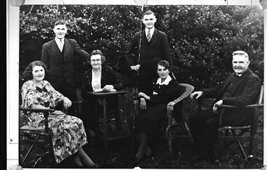 Southern Sherbrooke Historical Society Inc.
Photograph - The Johns family of Selby
B&W photo of the Johns family of Selby. Photo appears to date from c. 1930s. They are outside, with a hedge directly behind them. L-r, Martha Johns, a young woman sitting in a wooden chair. She is wearing a floral summer dress with a dark bow at the neckline. Martha was born in 1916. A young man, William David (Dave) Johns, stands, wearing a three-piece suit and tie. His left hand rests on the back of the chair of the next woman. This older woman, Alice, sits at a small table and has her left hand resting on an open book. She wears a dark skirt, light patterned blouse, and dark cardigan flecked with a lighter colour. She is wearing a necklace and she has round-framed glasses. Another young man, Ernest Johns, stands to her right. He is also dressed in three-piece suit and tie. He has his right hand placed on his right hip. A young woman, Florence Johns, sits in a wicker chair. She is wearing a dark outfit with a pale collar. Her hair is parted on the side and braided into two plaits. An older man, William John Johns, sits in a wooden chair. He is wearing a three-piece suit and tie. His waistcoat buttons up high on his chest, more of an old style suit than the two young men. He has grey hair and a moustache. All members of the group are smiling slightly. The photo was taken at the family farm, Hillandale, in Selby. Information provided by Lyn Kershaw, daughter of Dave Johns. -
 Ballarat Tramway Museum
Newspaper, The Courier Ballarat, "Ballarat support for tramway preservation is small: President", 25/09/1972 12:00:00 AM
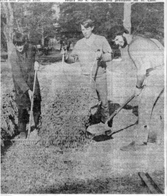
Has a strong association with the people who were involved in the early formation of the BTPS and the 1972 Annual General Meeting.Newspaper clipping from The Courier of Ballarat of Monday 25/9/1972 with two photos. Article quotes BTPS President saying support for the BTPS was still small. This followed the Annual General Meeting of the Society the previous Saturday. Other items were the trams had been transferred from the old SEC depot, Incorporation was being sought, track laying and maintenance work underway. Two photos 1084i1: - Photo shows Lindsay Bounds, Clyde Croft and David Wisher spreading gravel along No. 2 road. 1084i2: - Photo shows group of Board members at meeting: Mr. G. Netherway, Mr. M. Calnin, Mr. C.W.Jessup, Mr. R.Gilbert and Mr. H.Cain (President) See Reg Item 3824 for a print of the actual photograph. Second copy added 28/10/2005.On top edge of cutting in black ink "25/9/72"trams, tramways, btps, construction, museum establishment, agm -
 Ballarat Tramway Museum
Photograph - Colour Photograph/s set of 2, David Endacott, 19/09/1971 12:00:00 AM
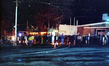
Two colour prints (Copies 1 and 2) of the scene at the Hospital Corner, Drummond St. Sth and Sturt St. after the running of the last tram from Sebastopol prior to running into the depot on 19 Sept. 1971. Shows one bogie tram No. 40 (from the advertising boards) with many people at the corner, a few cars and a police car leading the tram through the people standing around. Has the liquor store on the south west corner of the intersection in the background. Tram is heavily loaded with passengers. Copy 1 on Fujicolour Crystal Archive Paper is the better exposed and larger print and has been used in the scanned image.. Copy 2 another print off the same negative but with a smaller photograph area. Original film image scanned at 3200dpi 12/5/2020 and record revised. Image i2 - shows the crowd before the tram departed with a police escort. Image i3 - shows the scene as the tram departed with a police escort.On copy 2 - "The Last Tram at Drummond and Sturt Sts." in black ink.sebastopol, last tram, closure, hospital corner, tram 40 -
 Ballarat Tramway Museum
Photograph - Colour Photograph/s, David Endacott, 19/09/1971 12:00:00 AM
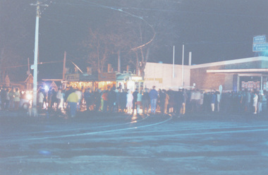
Two colour prints (Copies 1 and 2) of the scene at the Hospital Corner, Drummond St. Sth and Sturt St. after the running of the last tram from Sebastopol prior to running into the depot on 19 Sept. 1971. Shows one bogie tram No. 40 (from the advertising boards) with many people at the corner. Possibly taken after the police car has moved on, prior to the tram leaving for the depot after a few minutes. Has the liquor store on the south west corner of the intersection in the background. Tram is heavily loaded with passengers. Copy 1on Fujicolour Crystal Archive Paper is the better exposed and larger print and has been used in the scanned image.. Copy 2 another print off the same negative but with a smaller photograph area. Original film image scanned at 3200dpi 12/5/2020.On copy 2 - "Last tram to run in Ballaarat at Cnr Drummond & Sturt Sts on way to depot." in black ink.sebastopol, last tram, closure, hospital corner, tram 40 -
 Ballarat Tramway Museum
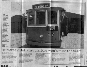
Newspaper, The Courier Ballarat, "Mid-week Ballarat visitors won't miss the tram" - 20/11/1997, 20/11/1997 12:00:00 AM
Clipping from page 3 of the Ballarat Courier newspaper of 20 November 1997 with photo and small news item of the BTM commencing Wednesday operations. Has same photo that later appeared in the Melbourne Herald Sun -(see item 727). Article written by Barbara Adam and photo by David Whelan See also November 1997 (with newspaper Clipping in storage folder) for details of Wednesday operations and the interview, story by Darren Hutchesson. See also Reg items 726 and 727. 730.1 - 2nd copy in better condition, 2nd copy added 25 June 1999. See BTM Fares Please! 1997 and Reg. item No. 726730 - On side of page "Courier 20/11/97 page 3" in blue inktrams, tramways, btm, tramcar operations -
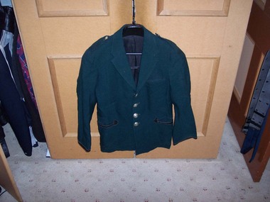 Ballarat Tramway Museum
Uniform - Uniform Jacket, David Lack Pty Ltd, early 1960's?
SECV Uniform Jacket - dark green cloth, lined with black cloth on inside and striped white cloth inside sleeves. Fitted with 4 silver large SECV uniform buttons on front, shoulder epaulets each fitted with small SECV uniform buttons, leather trimming on large pockets and ends of arms. Jacket fitted with four pockets - two side, one small top left and one large inside right. On top of inside of coat, "David Lack Pty Ltd. Melbourne" label, that can be used as a hanging point. On the inside right pocket, white label, with red and black printing, giving name of manufacturer and space for Name and Number. Typed for "T. Dunstan." and "926".ballarat, inspectors, uniforms -
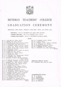 Bendigo Historical Society Inc.
Document - LA TROBE UNIVERSITY BENDIGO COLLECTION: BENDIGO TEACHERS' COLLEGE GRADUATION CEREMONY 1970
A white document titled "Bendigo Teachers' College Graduation Ceremony". Bendigo City Hall, Friday 11th Dec. 1970, at 10.30 A.M. Principal: Mr. K. G. Scarrott. Warden for Men: Mr.F. M. Courtis. Warden for Women: Mrs. H. J. Chatfield. Below this is a list of the staff at the college - Mr. T. J. McCabe, Mr. D. O'Brien, Mr. B. I. Rollins, Mr. R. F. Colbourne, Mr. B. A. Clemson, Mr. L. A. Hall, Mr. B. T. Geary, Mr. K. C. Coles, Mr. K. G. Harrison, Mr. B. R. Reed, Mr. J. A. White, Mr. G. L. Colson, Mr. A. D. Maltby, Mr. K. I. Clements, Mr. L. Jackman, Mr. D. R. Phelan, Mr. J. J. Layther, Mr. J. Brasier, Mr. R. B. Silverback, Mr. W. P. Lomas, Mr. J. P. Furnell, Mr. J. R. Goodrich, Mr. K. A. Ryrie, Mr. A. R. McIntosh, Mr. R. N. Teasdale, Mr. C. J. Barnes, Mr. R. J. Harris, Mr. R. Colliss, Mr. D. A. Jobling, J. R. R. McLeod, Mr. D. J. Watson, Mr. R. N. Bruce, Mrs. N. F. Fawdry, Mrs. H. A. Knox, Mrs. E. L. Perry, Mrs. M. M. Clemson, Mrs. R. M. Briggs, Mrs. M. P. Hibberd and Miss J. C. Burnett . Associate Medical Staff - Dr. S. Morphy and Administrative Staff: Mr. W. D. Kolle, Mrs. E. Morshead, Miss E. Christopher, Miss C. T. Aldridge and Mrs. D. M. Philpott. On the inside page is the "Significance of the Ceremony" and "The College Anthem". On the following page is a list of the students completing the Diploma of Teaching (Primary) 1968 - 1970 - Kaye Anderson, Marike Arro, Alan B. Baker, Avril L. Baker, Helen, J. Barnett, Madeline M. Beischer, Thelma J. Busch, Jenny A. Callender, Julie M. Cocks, Valerie Dealy, Sue J. Dudley, A. James Dunstone, Kath J. Fowler, Judy A. Gibb, James M. Goodall, Helen P. Gorman, Lindy A. Hall, J. Margaret Harkin, Jenny A. Henderson, Heather A. Hockley, Marilyn J. Hope, S. Lynn Humphry, Helen R. Jamieson, Gail E. Jolliff, Susan M. Jones, Mary Clare Kelly, N. Jenny Kennedy, R. John Leschke, Clare P. Lynch, Lois J. McConnell, Kay M. McDonald, Peter A. McManus, Margaret L. Mangan, Lorraine L. Matthews, Lois Monk, Frances M. Morgan, Genevieve M. Mulcair, Gail M. Norton, Helen M. Oliver, Colleen M. Orr, Rosemary F. Punton, Veronica E. Rahill, Peter J. Ryan, Robyn B. Schooling, Carol A. Scott, Richard W. Steele, Bruce W. Taylor, Jeanette M. Wallace, Lesley R. Wallis, Gwendoline M. Williams and Francis J. Wright. The Trained Primary Teacher's Certificate 1969 - 1970 was received by Rosena T. Amitrano, Ann E. Bennett, Jennifer E. Biggs, Philip L. Blackmore, Gayle D. Boase, Suzanne Brown, Paul T. Cairns, Julienne Cairns, Patricia Callanan, Sally Cariddi, Jennifer J. Carr, Helen Childs, Stephen M. Cope, Cheryl R. Coulstock, Carmel M. Doolan, Lynette R. Dowdell, Roseann C. Egan, Linda Ellis, Beverley J. Evans, Jillian Faderson, Judith Field, Anne E. Flynn, Rosemary J. Gardam, Valerie L. Green, J. Lindsay Harvey, Glenda M. Hepburn, Lynette D. Herdman, Helen M. Hodgson, Alyson C. Hyde, Pamela Jackson, May R. Jardine, Jennifer A. Jones, Barbara A. Kay, Gerrard A. Keogh, Bernadette Kerlin, Teresa M. Lavery, Judith A. Leneghan, Ann L. Licence, Aileen P. McAlister, Janet G. McCartney, Nola McConnell, Peter McCurry, Jacqueline E. McDonald, Margaret McHugh, Elizabeth A. McInnes, Barbara A. McLean, Lena J. Mariani, Jillian J. Martin, Louisa M. Merlin, Denise M. Miller, Dorothy J. Morshead, Christine A. Moss, Margaret Mulqueen, Penelope A. Murdoch, David Murray, Margaret M. O'Brien, Janice W. Pattison, Bronwyn A. Pease, Ian Perry, Angelika M. E. Petrovic, Beverly A. Pianta, Marianne L. Pollock, Julie C. Seipolt, Una Sims, Beth A. Small, Martin D. Smith, F. Elizabeth Spittal, Helen E. Stephens, Cheryl J. Sumner, Susan E. Tate, Suzanne Tate, Geoffrey L. Taylor, Cheryl Thomas, Jennifer A. Tope, Graham L. Turner, Lynette F. Turner, Margaret Wallis, Maureen T. White, Graham J. Whitlock, Julie A. Wilson, Jennifer A. Wood and Lynette J. Young. Also on this page are the names of students who completed external studies in the Trained Primary Teacher's Certificate - Margaret I. Anderson, Heather M. Collins, Margaret E. Gaskell, Marie A. Row, Sheryl F. Russell and Margaret E. Wilson. Denise J. Johnston completed her Trained Infant Teacher's Certificate externally. On the back cover is the "Order of the Ceremony". Mr. B. A. Clemson welcomed the visitors and the Principal Mr. K. G. Scarrott gave the Principal's message to graduands. Student representatives were presented to Mr. W. F. R. Budge by Mrs. H. Chatfield. Mr. F. M. Courtis presented the 1968-1970 Diploma of Teaching (Primary) to students and Mr. T. J. McCabe presented the 1969-1970 to T.P.T.C. students. Congratulations were offered by City of Bendigo, Cr. R. F. Turner, President of Strathfieldsaye Shire, Cr. R. W. Somerville and Principal of Golden Square State School Mr. R. Cordingley. The Occasional Address was given by Professor P. W. Musgrave and the President of the S.R.C. Mr. Peter McManus gave the Acknowledgement.bendigo, education, bendigo teachers' college graduatio, la trobe university bendigo collection, collection, bendigo teachers' college, bendigo, education, teaching, teachers, students, tertiary education, bendigo teachers' college staff, bendigo teachers' college students, graduands, graduation, graduation ceremony -
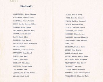 Bendigo Historical Society Inc.
Document - LA TROBE UNIVERSITY BENDIGO COLLECTION: BENDIGO TEACHERS' COLLEGE GRADUATION CEREMONY
A small cream copy of the 1952 Bendigo Teachers' College Graduation Ceremony. On the inside cover is a list of the Graduands - Robert Thomas Armstrong, Francis Arthur Baggage, Aileen Victoria Campbell, Coralie Beatrice Helen Cohn, Mary Therese Collins, Margaret Joan Crawford, Kevin Maurice Cullen, Dulcie Olive Dann, June Rachel Dolling, Lorna McPherson Donaldson, Dorothy Doyle, Kathleen Frances Farrell, Hugh Lionel Fawssett, Joan Mary Flynn, Peter John Gurry, Ailsa Jean Holland, Jeffrey James Layther, Maxwell John Lee, Ronald William Longstaff, Noel David Millar, Ronald Henry Ogier, Pamelia Margaret Pape, Margaret Alice Quick, Neil James Redfern, Elizabeth Ann Roberts, Margaret Elizabeth Roberts, Joan Margaret Rosengren, Neil Ross, Heather Dawn Sheehan, John Marley Sheen, Elizabeth Mary Sleep, William George Shand Smith, Joyce Margaret Spalding, Alan Robert Trethewey, Margaret Tripcony, Francis Elizabeth Verge, Kevin James Reynolds Warren and Elizabeth Marie Williamson. Within the program is a loose sheet of paper with a copy of the graduation procedure.bendigo, education, bendigo teachers' college graduatio, latrobe university bendigo collection, collection, bendigo teachers' college, bendigo, education, teaching, teachers, student, bendigo teachers' college graduation, graduation, bendigo teachers' college students, bendigo teachers' college staff, tertiary education, book, history -
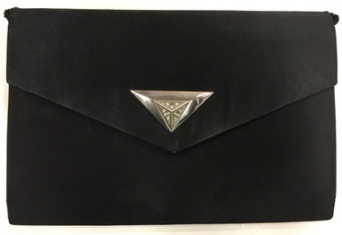 Kew Historical Society Inc
Accessory, David Jones Pty Ltd, Black Satin Evening Purse with Metal Clip & Chain, 1950s
The Kew Historical Society's Fashion & Design collection includes a small and representative collection of reticules, purses and handbags, purchased, inherited or collected by members of the Society. These items date from the Nineteenth and Twentieth centuries, and conform to fashions and styles popular during the period of their use. Some of the items are handmade, while others are mass-produced commercial products. Rectangular black silk art deco style evening bag with a white metal clasp set with diamentes.Label: "David Jones / Made in Italy"evening bags, women's clothing -- accessories, bags -- handbags, bags -- purses, fashion accessories -
Kew Historical Society Inc
Journal, Kew Historical Society, Newsletter No.98, February 2012
The Inaugural McIntyre Lecture / p1. East Kew School [East Kew Primary School] / Graeme Lindsay p2. Kew Festival at the Court House] / p2. President's address / David Benwell p3. [Blank] / p4-5. Members of Committee 2011-2012 / p6. Book Sales / p6. Vale [David Pitt 1916-2011, Sheila Pitt 1912-2011, Kenneth Silcock 1910-2011] / p6. One small shop [179 High Street, aka 61 Bulleen Road] / Judith Vimpani p7. 2012 Calendar / p8.Published quarterly since 1977, the newsletters of the Kew Historical Society contain significant research by members exploring relevant aspects of the Victorian and Australian Framework of Historical Themes. Frequently, articles on people, places and artefacts are the only source of information about an aspect of Kew, and Melbourne’s history.non-fictionThe Inaugural McIntyre Lecture / p1. East Kew School [East Kew Primary School] / Graeme Lindsay p2. Kew Festival at the Court House] / p2. President's address / David Benwell p3. [Blank] / p4-5. Members of Committee 2011-2012 / p6. Book Sales / p6. Vale [David Pitt 1916-2011, Sheila Pitt 1912-2011, Kenneth Silcock 1910-2011] / p6. One small shop [179 High Street, aka 61 Bulleen Road] / Judith Vimpani p7. 2012 Calendar / p8. kew historical society (vic.) -- periodicals., kew historical society (vic.) -- newsletters, kew historical society (vic.) -- journals