Showing 220 items
matching diamond creek - places
-
 Eltham District Historical Society Inc
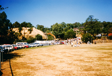
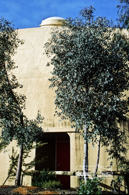
Photograph, Demolishing the Bini Shell at Diamond Creek, 1991, 1991
... the centre. Demotion took place during the Diamond Creek Town Fair... the centre. Demotion took place during the Diamond Creek Town Fair ...In 1978 Diamond Valley Shire recognised the need for a new public hall in Diamond Creek. Council considered the Bini shell form of construction which was in operation overseas and in use in New South Wales as libraries, gymnasiums, sports centres and multi-purpose centres. The Council gave the go-ahead. A site was chosen opposite the Hotel and close to the railway line. One day in - the following year, in 1979, activity stood still in Diamond Creek as school children and other excited spectators watched the one-hour inflation of the Bini Shell. This unusual method of construction was invented by Italian industrial designer and architect Dante Bini. The construction pneumatically raises a level of reinforced concrete from ground level which has not been set, using an internal balloon. The inner membrane inflates and compresses the mesh and concrete against the outer membrane. A net of flexible steel rods was laid on the building’s circular base, on the top of a fabric bladder. 300 tonnes of reinforced concrete were poured onto the mesh and a sealed cover laid over the concrete making a sandwich of cover, bladder and mesh. Compressed air was pumped into the bladder and the sandwich slowly began to rise and become a massive self-supporting dome. After inflation and removal of the outer membrane workmen filled in any holes. It was some days before pneumatic drills pecked out the first opening. The ceiling of the concrete dome was lined with fluffy insulating material. The dome was 36 metres in diameter at the base and 12 metres high in the centre with a usable floor space of 670 square metres. An opening night dinner was held to celebrate the new facility on March 12, 1980. Shire President Ron Pata made a speech and unveiled a plaque. It was the first public building in Victoria to be erected using the Bini Shell design method of construction The facility could cater for up to 400 people and in 1980 a fee for use was $100 for up to 200 people, $150 for up to 300 people and $200 for up to 400 people. For the next ten years or so, locals attended the hall for marital arts classes, basketball and netball games and school discoes and various other activities. After pieces of concrete fell off a Bini shell interstate due to a construction fault, the Council closed the centre. Demotion took place during the Diamond Creek Town Fair in 1991, as part of the annual Town Fair’s program. Research by L.P. Jan 2022This was the first public building in Victoria to be erected using the Bini Shell design method of construction.Colour photograph1991, diamond creek, bini shell, demolition, oval -
 Eltham District Historical Society Inc
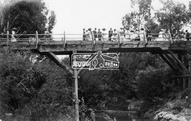
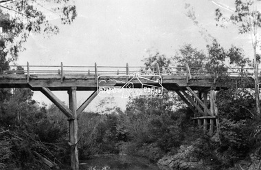
Negative - Photograph, Hurst's Bridge, c.1912
The area of Hurstbridge was originally known as Hurst’s-bridge after the timber bridge built over the Diamond Creek near Hurst’s station in late 1881/early 1882. A large group of people can be seen strolling across the timber bridge over the Diamond Creek on Hurstbridge-Arthurs Creek Road, Hurstbridge. It was built by John McDonald, of Arthur's Creek and was demolished and replaced in 1917 by a reinforced concrete arch bridge designed by John Monash.This photo forms part of a collection of photographs gathered by the Shire of Eltham for their centenary project book, "Pioneers and Painters: 100 years of the Shire of Eltham" by Alan Marshall (1971). The collection of over 500 images is held in partnership between Eltham District Historical Society and Yarra Plenty Regional Library (Eltham Library) and is now formally known as 'The Shire of Eltham Pioneers Photograph Collection.' It is significant in being the first community sourced collection representing the places and people of the Shire's first one hundred years.Digital image 4 x 5 inch B&W Negshire of eltham pioneers photograph collection, 1912, bridge, diamond creek (creek), hurstbridge, hurst's bridge -
 Eltham District Historical Society Inc
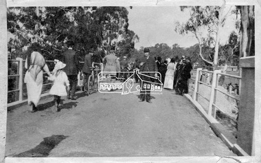
Photograph, Hurstbridge - Cr. Price crossing New Bridge (Opening Day), 1917, 1917
Eltham Shire Councillor Albert Price joined over 500 spectators for the official opening of the new re-inforced concrete bridge across the Diamond Creek at Hurstbridge. Eltham Shire shared the cost of the construction of the bridge with Heidelberg and Whittlesea Shires.This photo forms part of a collection of photographs gathered by the Shire of Eltham for their centenary project book, "Pioneers and Painters: 100 years of the Shire of Eltham" by Alan Marshall (1971). The collection of over 500 images is held in partnership between Eltham District Historical Society and Yarra Plenty Regional Library (Eltham Library) and is now formally known as 'The Shire of Eltham Pioneers Photograph Collection.' It is significant in being the first community sourced collection representing the places and people of the Shire's first one hundred years.Digital imagesepp, shire of eltham pioneers photograph collection, diamond creek, hurstbridge, wattle glen, bridge, councilor price, opening day, diamond creek (river) -
 Eltham District Historical Society Inc
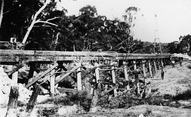
Photograph, Railway Bridge construction between Eltham and Hurstbridge, c.1912
The railway was extended from Eltham to Hurstbridge in 1912. This bridge is most likely near Allendale Road, Diamond Creek. It was one of four original trestle bridges in the stretch north of Allendale Road, which were all burnt out in January 1969 (replaced by two steel bridges and two corrugated iron culverts).This photo forms part of a collection of photographs gathered by the Shire of Eltham for their centenary project book,"Pioneers and Painters: 100 years of the Shire of Eltham" by Alan Marshall (1971). The collection of over 500 images is held in partnership between Eltham District Historical Society and Yarra Plenty Regional Library (Eltham Library) and is now formally known as the 'The Shire of Eltham Pioneers Photograph Collection.' It is significant in being the first community sourced collection representing the places and people of the Shire's first one hundred years.Digital image One 4 x 5 inch B&W negative One 9 x 12.5 cm printshire of eltham pioneers photograph collection, hurstbridge, allendale road, hurstbridge railway extension, railway bridge, railway line construction, trestle bridge, diamond creek (creek) -
 Eltham District Historical Society Inc
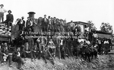
Photograph, First steam train to Hurstbridge
A large group of men of varying ages stand on or beside the first steam train to Hurstbridge. Two hold children on their laps. A small group of seven boys also gather for the photo. The line opened on 2 January 1912 and was officially opened in June.The photo commemorates the culmination of many years of community and political agitation for the extension of the railway line. 100 years later the Hurstbridge railway line remains a vital part of Melbourne's public transport network. This photo forms part of a collection of photographs gathered by the Shire of Eltham for their centenary project book, "Pioneers and Painters: 100 years of the Shire of Eltham" by Alan Marshall (1971). The collection of over 500 images is held in partnership between Eltham District Historical Society and Yarra Plenty Regional Library (Eltham Library) and is now formally known as 'The Shire of Eltham Pioneers Photograph Collection.' It is significant in being the first community sourced collection representing the places and people of the Shire's first one hundred years.Digital image Also black and white copy of original mounted photo (broken) printed on glossy photographic paper 30.5 x 40.5 cm; image size approx. 18.5 x 28 cm (One of 36 photos (5 with duplicate prints) from Kevin Patterson of Nillumbik Historical Society, no captions, subjects largely unknown but mostly of Diamond Creek area and people.)sepp, shire of eltham pioneers photograph collection, hurstbridge, steam train, railroads, group, hurstbridge railway line, steam engine, diamond creek, wattle glen, railway line -
 Eltham District Historical Society Inc
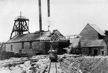
Photograph, Diamond Creek Gold Mine
Situated at the end of Fraser Street, Diamond Creek. The Diamond Creek Gold Mine was the largest in the Diamond Valley Shire with a shaft depth of over 290 metres at the peak of its development in 1915. The surface plant was quite large with four boilers and five steam engines working the battery, winder, water pump, air compressor and lighting generator.This photo forms part of a collection of photographs gathered by the Shire of Eltham for their centenary project book, "Pioneers and Painters: 100 years of the Shire of Eltham" by Alan Marshall (1971). The collection of over 500 images is held in partnership between Eltham District Historical Society and Yarra Plenty Regional Library (Eltham Library) and is now formally known as 'The Shire of Eltham Pioneers Photograph Collection.' It is significant in being the first community sourced collection representing the places and people of the Shire's first one hundred years.Digital imagesepp, shire of eltham pioneers photograph collection, diamond creek, goldmine, gold mine, poppet head -
 Eltham District Historical Society Inc
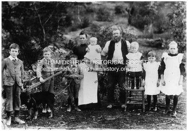
Negative - Photograph, Sabina and Will Mills and family, Upper Diamond Creek (Wattle Glen), c.1899
Sabina and William Henry Mills lived at "Golden Valley", Upper Diamond Creek (Wattle Glen) and had nine children in total. Here they are pictured with seven young children. Sabina died in 1916 aged 57 and William died in 1921 age 64. They are buried together at Diamond Creek (Nillumbik) cemetery. Reproduced on p46 of 'Pioneers & Painters'This photo forms part of a collection of photographs gathered by the Shire of Eltham for their centenary project book, "Pioneers and Painters: 100 years of the Shire of Eltham" by Alan Marshall (1971). The collection of over 500 images is held in partnership between Eltham District Historical Society and Yarra Plenty Regional Library (Eltham Library) and is now formally known as 'The Shire of Eltham Pioneers Photograph Collection.' It is significant in being the first community sourced collection representing the places and people of the Shire's first one hundred years.Digital image 4 x 5 inch B&W Neg 20 x 25 cm printsepp, shire of eltham pioneers photograph collection, wattle glen, sabina mills, will mills, mills family, pioneers and painters, upper diamond creek -
 Eltham District Historical Society Inc
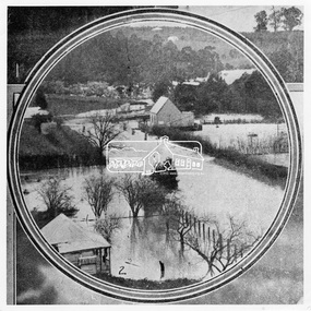
Photograph, Leader Publishing Co, Floods at Diamond Creek, Sep. 1924
The Diamond Creek in flood in Diamond Creek township. View north along Diamond Street. The building in the middle distance is the Methodist Church. From "The Leader", 6 September 1924.This photo forms part of a collection of photographs gathered by the Shire of Eltham for their centenary project book, "Pioneers and Painters: 100 years of the Shire of Eltham" by Alan Marshall (1971). The collection of over 500 images is held in partnership between Eltham District Historical Society and Yarra Plenty Regional Library (Eltham Library) and is now formally known as 'The Shire of Eltham Pioneers Photograph Collection.' It is significant in being the first community sourced collection representing the places and people of the Shire's first one hundred years.Digital imageshire of eltham pioneers photograph collection, diamond creek, floods, methodist church, diamond creek (creek), diamond street, 1924 -
 Eltham District Historical Society Inc
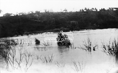
Negative - Photograph, Diamond Creek in Flood, c.1916
Original information recorded with this image suggested the date was 1918 however that was not a significant flood year for the the Diamond Creek at Hurstbridge. Of more significance was 1916. This scene is understood to be somewhere near Wattle Glen and Hurstbridge.This photo forms part of a collection of photographs gathered by the Shire of Eltham for their centenary project book,"Pioneers and Painters: 100 years of the Shire of Eltham" by Alan Marshall (1971). The collection of over 500 images is held in partnership between Eltham District Historical Society and Yarra Plenty Regional Library (Eltham Library) and is now formally known as the 'The Shire of Eltham Pioneers Photograph Collection.' It is significant in being the first community sourced collection representing the places and people of the Shire's first one hundred years.Digital image 4 x 5 inch B&W Negshire of eltham pioneers photograph collection, hurstbridge, wattle glen, floods, diamond creek (creek) -
 Eltham District Historical Society Inc
Negative - Photograph, Diamond Creek floodwater at Monash Bridge, Hurstbridge, Dec. 1934
The historic 1934 flood of the Diamond Creek and Yarra River following the storms of 29-30 November set the levels for future planning with respect to flood water rise.This photo forms part of a collection of photographs gathered by the Shire of Eltham for their centenary project book,"Pioneers and Painters: 100 years of the Shire of Eltham" by Alan Marshall (1971). The collection of over 500 images is held in partnership between Eltham District Historical Society and Yarra Plenty Regional Library (Eltham Library) and is now formally known as the 'The Shire of Eltham Pioneers Photograph Collection.' It is significant in being the first community sourced collection representing the places and people of the Shire's first one hundred years.Digital image 4 x 5 inch B&W Negshire of eltham pioneers photograph collection, hurstbridge, 1934 flood, floods, monash bridge, diamond creek (creek) -
 Eltham District Historical Society Inc
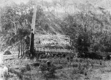
Negative - Photograph, J. P. Lind, Hurst's Bridge, 1885
Looking northwest onto the first bridge at Hurstbridge, 1885. Timber bridge amid rural setting. Two horses graze in an open paddock in the foreground. A house is situated on a rise behind the bridge on a tree lined hill. The area of Hurstbridge was originally known as Hurst’s-bridge after the timber bridge built over the Diamond Creek near Hurst’s station in late 1881/early 1882 on the Hurstbridge-Arthurs Creek Road, Hurstbridge. It was built by John McDonald, of Arthur's Creek and was demolished and replaced in 1917 by a reinforced concrete arch bridge designed by John Monash. Cross Reference Photo No.(s): 1012/1013This photo forms part of a collection of photographs gathered by the Shire of Eltham for their centenary project book, "Pioneers and Painters: 100 years of the Shire of Eltham" by Alan Marshall (1971). The collection of over 500 images is held in partnership between Eltham District Historical Society and Yarra Plenty Regional Library (Eltham Library) and is now formally known as 'The Shire of Eltham Pioneers Photograph Collection.' It is significant in being the first community sourced collection representing the places and people of the Shire's first one hundred years.Digital image 4 x 5 inch B&W Negshire of eltham pioneers photograph collection, hurstbridge, bridge, diamond creek (river), diamond creek (creek), hurst's bridge -
 Eltham District Historical Society Inc
Negative - Photograph, Hurst's Bridge, 1885
Looking northwest onto the first bridge at Hurstbridge, 1885. The area of Hurstbridge was originally known as Hurst’s-bridge after the timber bridge built over the Diamond Creek near Hurst’s station in late 1881/early 1882 on the Hurstbridge-Arthurs Creek Road, Hurstbridge. It was built by John McDonald, of Arthur's Creek and was demolished and replaced in 1917 by a reinforced concrete arch bridge designed by John Monash. Cross Reference Photo No.(s): 1012/1013This photo forms part of a collection of photographs gathered by the Shire of Eltham for their centenary project book,"Pioneers and Painters: 100 years of the Shire of Eltham" by Alan Marshall (1971). The collection of over 500 images is held in partnership between Eltham District Historical Society and Yarra Plenty Regional Library (Eltham Library) and is now formally known as the 'The Shire of Eltham Pioneers Photograph Collection.' It is significant in being the first community sourced collection representing the places and people of the Shire's first one hundred years.Digital image 4 x 5 inch B&W Negshire of eltham pioneers photograph collection, hurstbridge, bridge, diamond creek (creek), hurst's bridge -
 Eltham District Historical Society Inc
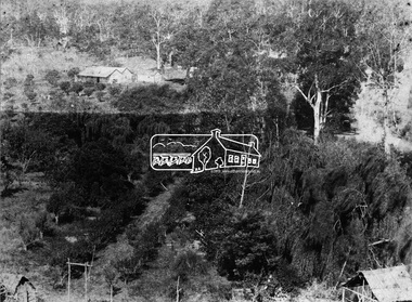
Photograph, Allwood, Hurstbridge, 1885
Allwood at Hurstbridge was named and first settled in 1837 by the Haley family. A house was built of one round of vertical slabs (red gum). Later it was the Hurst family home where Henry Hurst was shot by Burke the Bushranger on 4 October 1886. George Gray took over the property and the original home was eventually demolished. Gray, a fruit grower established an orchard and Allwood Nurseries which became a very successful business growing and exporting. This is probably around the time when this photo was taken where rows of fruit trees can be seen in the foreground. A house and associated buildings, possibly part of the nursery are behind. This photo forms part of a collection of photographs gathered by the Shire of Eltham for their centenary project book, "Pioneers and Painters: 100 years of the Shire of Eltham" by Alan Marshall (1971). The collection of over 500 images is held in partnership between Eltham District Historical Society and Yarra Plenty Regional Library (Eltham Library) and is now formally known as 'The Shire of Eltham Pioneers Photograph Collection.' It is significant in being the first community sourced collection representing the places and people of the Shire's first one hundred years.Digital imagesepp, shire of eltham pioneers photograph collection, diamond creek, hurstbridge, allwood, orchard -
 Eltham District Historical Society Inc
Photograph, Hurst's Bridge, c.1912
The area of Hurstbridge was originally known as Hurst’s-bridge after the timber bridge built over the Diamond Creek near Hurst’s station in late 1881/early 1882 on Hurstbridge-Arthurs Creek Road, Hurstbridge. It was built by John McDonald, of Arthur's Creek and was demolished and replaced in 1917 by a reinforced concrete arch bridge designed by John Monash. Part of a slide show presentation "Bridges & Waterways of the Shire" by Russell Yeoman to the 13 September 1989 Society meeting. The presentation included slides of historic photos from the Shire of Eltham Pioneers collections as well as several recent views. This photo forms part of a collection of photographs gathered by the Shire of Eltham for their centenary project book, Pioneers and Painters: 100 years of the Shire of Eltham" by Alan Marshall (1971). The collection of over 500 images is held in partnership between Eltham District Historical Society and Yarra Plenty Regional Library (Eltham Library) and is now formally known as 'The Shire of Eltham Pioneers Photograph Collection.' It is significant in being the first community sourced collection representing the places and people of the Shire's first one hundred years.Digital imageshire of eltham pioneers photograph collection, 1912, bridge, diamond creek (creek), hurstbridge, hurst's bridge -
 Eltham District Historical Society Inc
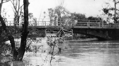
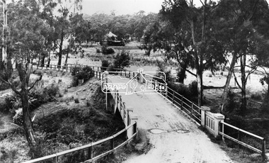
Negative - Photograph, View across bridge at Hurstbridge, Vic, c.1922
View across the new Monash bridge across the Diamond Creek at Hurstbridge looking towards the township, note steam train in centre background of image. Dated between the opening of bridge Nov. 1917 and provision of electric rail service Aug. 1926 - c.1922. Part of a slide show presentation "Bridges & Waterways of the Shire" by Russell Yeoman to the 13 September 1989 Society meeting. The presentation included slides of historic photos from the Shire of Eltham Pioneers collections as well as several recent views.This photo forms part of a collection of photographs gathered by the Shire of Eltham for their centenary project book ,"Pioneers and Painters: 100 years of the Shire of Eltham" by Alan Marshall (1971). The collection of over 500 images is held in partnership between Eltham District Historical Society and Yarra Plenty Regional Library (Eltham Library) and is now formally known as 'The Shire of Eltham Pioneers Photograph Collection.' It is significant in being the first community sourced collection representing the places and people of the Shire's first one hundred years.Digital image 4 x 5 inch B&W Negshire of eltham pioneers photograph collection, hurstbridge, bridge, steam train, diamond creek (creek), railway line, monash bridge -
 Eltham District Historical Society Inc
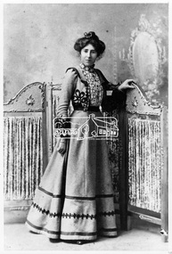
Photograph, Ada Alice Hurst, 1900
Portrait of Ada Alice Hurst who was the youngest daughter of Frederick Hurst of Hurstbridge. She married Claude Frederick Pizzey in 1907 and lived at Diamond Creek. Claude was the son of George Pizzey of "Claremont" Diamond Creek. She died on 25 July 1910, aged 30 at their home "Moana", Mitchell Street, Northcote. She is buried in the Diamond Creek cemetery. This photo forms part of a collection of photographs gathered by the Shire of Eltham for their centenary project book, "Pioneers and Painters: 100 years of the Shire of Eltham" by Alan Marshall (1971). The collection of over 500 images is held in partnership between Eltham District Historical Society and Yarra Plenty Regional Library (Eltham Library) and is now formally known as 'The Shire of Eltham Pioneers Photograph Collection.' It is significant in being the first community sourced collection representing the places and people of the Shire's first one hundred years.Digital imagesepp, shire of eltham pioneers photograph collection, diamond creek, hurstbridge, hurst family, ada alice hurst, claude pizzey -
 Eltham District Historical Society Inc
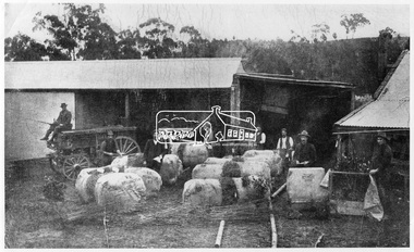
Photograph, Allwood Nurseries, Diamond Creek, Vic
Allwood Nurseries in Hurstbridge was operated by W.G (William George) Gray. By 1922 he operated a well cultivated property of 64 cleared acres, 56 of which were under nursery healthy stock, principally apples, peaches, plums and cherries. In addition to 4 acres of potatoes. He grew seedling stock which he supplied to other local orchardists and the overseas market. This photo forms part of a collection of photographs gathered by the Shire of Eltham for their centenary project book, "Pioneers and Painters: 100 years of the Shire of Eltham" by Alan Marshall (1971). The collection of over 500 images is held in partnership between Eltham District Historical Society and Yarra Plenty Regional Library (Eltham Library) and is now formally known as 'The Shire of Eltham Pioneers Photograph Collection.' It is significant in being the first community sourced collection representing the places and people of the Shire's first one hundred years.Digital imagesepp, shire of eltham pioneers photograph collection, hurstbridge, allwood nurseries, export, nursery -
 Eltham District Historical Society Inc
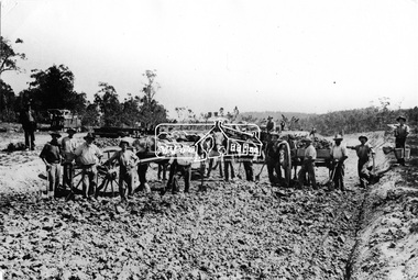
Photograph, Excavating Railway Cutting to Hurstbridge
Labourers excavate a cutting for the new railiway extension from Eltham to Hurstbridge. Men are working with shovels and buckets, dropping dirt into horse and carts. A pile of newly cut sleepers sit on the sidelines waiting to be laid. The new extension is approx. seven miles in length and opened on 2 January, 1912.This photo forms part of a collection of photographs gathered by the Shire of Eltham for their centenary project book, "Pioneers and Painters: 100 years of the Shire of Eltham" by Alan Marshall (1971). The collection of over 500 images is held in partnership between Eltham District Historical Society and Yarra Plenty Regional Library (Eltham Library) and is now formally known as 'The Shire of Eltham Pioneers Photograph Collection.' It is significant in being the first community sourced collection representing the places and people of the Shire's first one hundred years.Digital imagesepp, shire of eltham pioneers photograph collection, diamond creek, hurstbridge, wattle glen, railway line construction, railroad construction workers, railroad construction -
 Eltham District Historical Society Inc
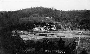
Photograph, Hurstbridge - Showing Railway Station
View overlooking the township and surrounding hills of Hurstbridge. The new railway line and station and accompanying works are central. The extension from Eltham to Hurstbridge opened on 2 January 1912.This photo forms part of a collection of photographs gathered by the Shire of Eltham for their centenary project book, "Pioneers and Painters: 100 years of the Shire of Eltham" by Alan Marshall (1971). The collection of over 500 images is held in partnership between Eltham District Historical Society and Yarra Plenty Regional Library (Eltham Library) and is now formally known as 'The Shire of Eltham Pioneers Photograph Collection.' It is significant in being the first community sourced collection representing the places and people of the Shire's first one hundred years.Digital imagesepp, shire of eltham pioneers photograph collection, diamond creek, hurstbridge, railway station, railroad, railway line -
 Eltham District Historical Society Inc
Photograph, Fred Mitchell, Bini Shell at Diamond Creek, 1983, 1983
... the centre. Demotion took place during the Diamond Creek Town Fair... the centre. Demotion took place during the Diamond Creek Town Fair ...In 1978 Diamond Valley Shire recognised the need for a new public hall in Diamond Creek. Council considered the Bini shell form of construction which was in operation overseas and in use in New South Wales as libraries, gymnasiums, sports centres and multi-purpose centres. The Council gave the go-ahead. A site was chosen opposite the Hotel and close to the railway line. One day in - the following year, in 1979, activity stood still in Diamond Creek as school children and other excited spectators watched the one-hour inflation of the Bini Shell. This unusual method of construction was invented by Italian industrial designer and architect Dante Bini. The construction pneumatically raises a level of reinforced concrete from ground level which has not been set, using an internal balloon. The inner membrane inflates and compresses the mesh and concrete against the outer membrane. A net of flexible steel rods was laid on the building’s circular base, on the top of a fabric bladder. 300 tonnes of reinforced concrete were poured onto the mesh and a sealed cover laid over the concrete making a sandwich of cover, bladder and mesh. Compressed air was pumped into the bladder and the sandwich slowly began to rise and become a massive self-supporting dome. After inflation and removal of the outer membrane workmen filled in any holes. It was some days before pneumatic drills pecked out the first opening. The ceiling of the concrete dome was lined with fluffy insulating material. The dome was 36 metres in diameter at the base and 12 metres high in the centre with a usable floor space of 670 square metres. An opening night dinner was held to celebrate the new facility on March 12, 1980. Shire President Ron Pata made a speech and unveiled a plaque. It was the first public building in Victoria to be erected using the Bini Shell design method of construction The facility could cater for up to 400 people and in 1980 a fee for use was $100 for up to 200 people, $150 for up to 300 people and $200 for up to 400 people. For the next ten years or so, locals attended the hall for marital arts classes, basketball and netball games and school discoes and various other activities. After pieces of concrete fell off a Bini shell interstate due to a construction fault, the Council closed the centre. Demotion took place during the Diamond Creek Town Fair in 1991, as part of the annual Town Fair’s program. Research by LP January 2022This was the first public building in Victoria to be erected using the Bini Shell design method of construction.Digital copy of colour photographfred mitchell collection, 1983, bini shell, diamond creek -
 Nillumbik Historical Society Incorporated
Book - Softcover book, Hugh Anderson, Ringwood Place of Many Eagles A Bicentennial History
Front cover has photograph of clock tower in parkland and back cover with historic photograph of Ringwood - 282 pages including indexnon-fiction -
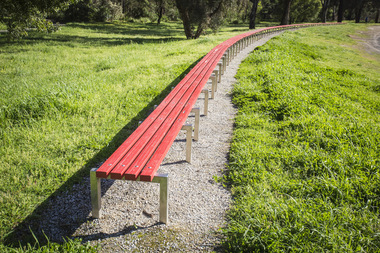 Nillumbik Shire Council
Public Art: Susie KUMAR & Naomi KUMAR, Benchmark (Location: Conventry Oval, Elizabeth Street, Diamond Creek), 1997
1996 Nillumbik Art in Public Places Award (installed late 1997). A biennial program that ceased in 2007. The program commissioned artists to make and install public art in various sites around the Shire. Award judges that year were Tony Trembath and artist Peter D. Cole. Susie Kumar has a Bachelor of Landscape Architecture degree from RMIT and Naomi Kumar has a Bachelor of Fine Art in photography degree from VCA. The Kumar sisters designed the sixty meter gently curving bench in response to the topography of the site, Conventry Oval. The sculpture is designed to describe the boundary between the formal oval and the natural creek bank and a considered relationship to the bike track and the river. It forms a link between the activities and aesthetics of its environment. The work is a comical interpretation of the utilitarian public bench. From a distance the bright red runners (the colour of the local football team's stripe) appear to float about the surrounding green. One end of the work is straight and finished. The other remains 'unfinished' hence allowing for the concept of unlimited extension. The 'legs' (steel hurdles) are arranged with a sense of movement and rhythm in sympathy with the activities happening around the work and with the stands of trees in he background. 'Benchmark' also serves as a functional purpose; providing a choice of places to sit to watch action on the oval. Stainless steel, timber (Victorian Ash) and red enamel paint. Sixty meter long red bench that gently curves in response to Conventry Oval. Bolted on top of evenly spaced stainless steel hurdles, four rows of timber runners are joined to provide unbroken continuous lengths. The bench stands on a framed bed of crushed rock (Lilydale topping).N/Abench, sport, wood, victorian ash, stainless steel, public art, ekphrasis2017 -
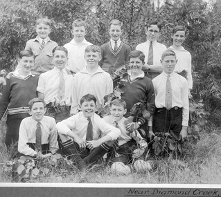 St Patrick's Old Collegians Association (SPOCA)
Photograph - Students, 1920s
-
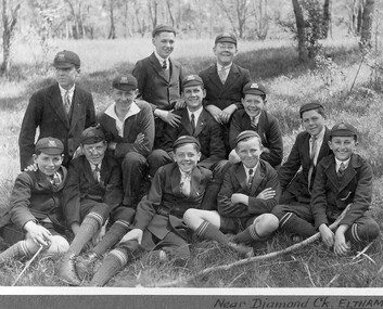 St Patrick's Old Collegians Association (SPOCA)
Photograph - Students, 1920s
-
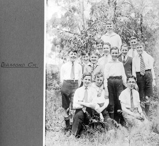 St Patrick's Old Collegians Association (SPOCA)
Photograph - Students, 1920s
-
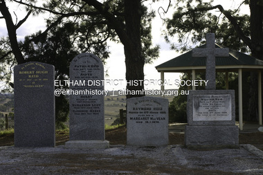 Eltham District Historical Society Inc
Photograph - Digital Photograph, Alan King, Reid family graves, Arthurs Creek Cemetery, 30 March 2008
The Arthurs Creek Cemetery was originally the private cemetery of pioneers Agnes and Patrick Reid. Published: Nillumbik Now and Then / Marguerite Marshall 2008; photographs Alan King with Marguerite Marshall.; p11 The Hazel Glen property, at Middle Hut Road, Arthurs Creek, which includes one of Victoria’s earliest pioneer buildings, was the forerunner to the Arthurs Creek and Doreen townships. At one time the Doreen Post Office and school were called Hazel Glen. The Hazel Glen State School No 945, before it was moved to its present site, stood on land to the south of Chapel Lane, which had been donated by Hazel Glen owner, William Reid. In May 1895 the post office was renamed Doreen to avoid confusion with the Reid’s address. The Arthurs Creek Cemetery was originally the private cemetery of Hazel Glen pioneers Agnes and Patrick Reid. The Reids with their eight children, arrived in Melbourne in April 1839. In 1844 Patrick Reid took over the licence to the Stewart Ponds run of 5120 acres (2072ha). Reid renamed it Hazel Glen, after Hazelden, the name of the Reid estate at Mearns in Renfrewshire, Scotland. Reid built a small cottage from local stone and hand-made bricks, with walls one yard (91 cm) thick, a flagstone floor and a shingle roof. Today two rooms and a store room survive as part of a larger house. Agnes died in 1847 aged 49, and was buried on a hill overlooking Hazel Glen, where it is said she had asked to be buried as it had been a favourite picnic spot.2 In 1858 Patrick died aged 74, and was buried near her. Their son William was to become Whittlesea Shire’s first president. From 1868 he was a Whittlesea Roads Board member, then a shire councillor until shortly before his death in 1923 aged 88. In 1865 the Reid’s burial area was no longer on their property, so it was declared a cemetery site. In 1867 it became the Linton Public Cemetery, being in the Linton Parish. However, to avoid confusion with Linton near Ballarat, the cemetery was renamed the Arthurs Creek Public Cemetery in 1926. Arthurs Creek was named after Henry Arthur, a pastoralist and public servant, who ran 1000 sheep lower down the Creek, from 1836 to 1841. It is believed he built his home at the end of today’s Challenger Street in Diamond Creek.This collection of almost 130 photos about places and people within the Shire of Nillumbik, an urban and rural municipality in Melbourne's north, contributes to an understanding of the history of the Shire. Published in 2008 immediately prior to the Black Saturday bushfires of February 7, 2009, it documents sites that were impacted, and in some cases destroyed by the fires. It includes photographs taken especially for the publication, creating a unique time capsule representing the Shire in the early 21st century. It remains the most recent comprehenesive publication devoted to the Shire's history connecting local residents to the past. agnes reid, arthurs creek cemetery, nillumbik now and then (marshall-king) collection, patrick reid, reid family -
 Eltham District Historical Society Inc
Photograph - Digital Photograph, Alan King, Golden King Mine poppet-head, Yarrambat Primary School, 1 February 2008
The Golden King Mine poppet-head stands at the school’s Yan Yean Road exit gate. Published: Nillumbik Now and Then / Marguerite Marshall 2008; photographs Alan King with Marguerite Marshall.; p23 Early Yarambat - Tanck's Corner Its early settlers, who in the 1840s were amongst the first non-Aboriginal people in the area, found life tough as they grazed their sheep and cattle. Yarrambat was then known as Tanck’s Corner or Reynolds Corner, after wood carter, Frederick Tanck, who owned land north of Ironbark Road, at the corner of Yan Yean Road, and Thomas Reynolds, owner of the opposite property. After Reynolds sold his land, the corner became known as Tanck’s Corner. In 1929 the district’s name was changed to Yarrambat, believed to mean ‘high hill’ in the Wurundjeri language. Tanck’s Corner was in the centre of gold-bearing country and the district is honeycombed with old tunnels and shafts. However although gold played a dominant role for decades, there was insufficient to develop a substantial township. Meat and agricultural produce made a greater impact. Until the mid-20th century the only substantial building was the primary school. The first gold rush occurred around 1860, the second after 1900; then during the Depression, the Government paid men to pan for gold. The first rush attracted hundreds of Chinese people to Smugglers Gully, who constructed round diggings to keep away spirits. Alluvial miners lived along the Plenty River in tents or humpies - some fenced with gardens - and some miners distilled their own ‘plonk’. It was a wild time and bushrangers - and later gangster Squizzy Taylor - were said to hide4 in the old Pioneer Tunnel in Dunne’s Gully between Heard Avenue and Pioneer Road. Mines opposite Tanck’s Corner included Beer’s Line, Golden Crown and Golden Stairs. Some of the big mines had batteries and stampers to process quartz. At first there was plenty of alluvial gold, as much as two ounces to the ton. At times gold was exposed after heavy rains so fossickers panned for gold around orchard irrigation trenches. Gold was mined until 1984 when Yarrambat’s last operating goldmine, the Golden King Mine, in North Oatlands Road, closed. The Clayton family operated it full-time, making a comfortable living and in the 1960s it was the only private family gold mine in Victoria.5 Gold was such an important part of Yarrambat’s history that a gold poppet-head is the Yarrambat Primary School’s logo. The Golden King Mine poppet-head stands at the school’s Yan Yean Road exit gate. However this school was built in 1988. The original school No 2054, at the corner of Ironbark and Yan Yean Roads, was opened in 1878 and modified to its present form in the 1920s. In 2000 it was relocated to the Heritage Museum at Yarrambat Park.7 The school, whose first head teacher was Charles Planner, consisted of one room with a three-roomed residence. The school was also the community centre. On Saturday nights it was crammed for dances or euchre parties, community singing or other social events. On Sundays, services for different denominations took turns each week. However the school had its teething problems. Parents accused Charles Planner of neglecting his duties and the school closed several times. When it closed in 1892, only church services continued. Social activities moved elsewhere, such as the tennis club to the Stuchbery tennis court opposite. A sports day and woodchop on Boxing Day around 1900 was held at the Evelyn Hill Hotel, also called Evelyn Arms and Tunnel Hill Hotel, on the Greensborough–Diamond Creek Road. An annual agricultural show in Diamond Creek paraded through the town, and New Year’s Day picnics at the Yan Yean Reservoir included highland dancing and competitions. Also popular were the Indian hawkers who visited every three months, selling trinkets, clothing and other items. One called Jimmy ‘Allem dem Bedi’, gave presents and told stories, played draughts and sold delicious curries he cooked over his camp fire at night.This collection of almost 130 photos about places and people within the Shire of Nillumbik, an urban and rural municipality in Melbourne's north, contributes to an understanding of the history of the Shire. Published in 2008 immediately prior to the Black Saturday bushfires of February 7, 2009, it documents sites that were impacted, and in some cases destroyed by the fires. It includes photographs taken especially for the publication, creating a unique time capsule representing the Shire in the early 21st century. It remains the most recent comprehenesive publication devoted to the Shire's history connecting local residents to the past. nillumbik now and then (marshall-king) collection, golden king mine, tanck's corner, yarrambat primary school -
 Eltham District Historical Society Inc
Photograph - Digital Photograph, Marguerite Marshall, Eltham Lower Park, 20 April 2008
Originally a race course, the park has brought the community together with a variety of activities. Published: Nillumbik Now and Then / Marguerite Marshall 2008; photographs Alan King with Marguerite Marshall.; p45 Once used for horse racing, which attracted visitors from Melbourne, the Eltham Lower Park has brought the community together with a wide range of activities. Horse riding is now enjoyed as a recreation in the park as are other sports. The park also includes the Diamond Valley Railway miniature trains and a sanctuary for the rare and vulnerable Eltham Copper Butterfly. Eltham Lower Park, with other parks, forms an almost continuous green band from Eltham’s centre, along the Diamond Creek to the Yarra River.1 Before European settlement the Wurundjeri people met on this land, particularly at the junction of the Diamond Creek with the Yarra River, which they called Birr-arung. This is commemorated by the sculpture, Not just a Pretty Place by Aleks Danko, winner of the 2000 Nillumbik Art in Public Places Award. The first European to settle here was probably Henry Foley, who in 1841 used it as part of his pastoral run. Foley sold his leasehold to Joseph Wilson in 1845, who soon after sold it to Frederick Falkiner. During the 1840s the future park was part of a government square mile (2.6 sqkm) reserve, north of the Yarra, within the Parish of Nillumbik, later named Eltham. Soon the land was used for horse racing after nearby residents cleared ten acres (4ha) in the early 1850s. A three-quarter of a mile (1.2km) race secured the winner the £10 Publican’s Prize. In response to popular demand, the newly formed Eltham District Road Board petitioned the Surveyor General of the Colony of Victoria, in 1856, for 36 acres (14.6ha) of crown land for a racecourse and recreation. By 1858 the Eltham races had become an institution. ‘Many skirmishes occurred and the way home was paved with temptation, with sly-grog for sale.3 In the early 1870s, two jockeys were sons of the police officer in charge of the Eltham Police Station, Miles S Lyons. Another ten acres (4ha) was added to the area in 1866 and 12 acres (4.8ha) – Hohnes Hill – in 1870. In 1866, two acres (0.8ha) on the creek banks became an animal pound with William Walsh the pound keeper in 1870, but this was later incorporated into the park. By 1877 the area was called a public park but horse racing and training continued into the 1920s. In the mid-1900s trotters were trained on a circuit road. In 1953 the Eltham Pony Club was established and used a cross-country course on Hohnes Hill. From the mid 1950s the club held the Eltham Easter Fair at the park, later to include a procession along Main Road from the town centre to the park. The park also attracted picnic parties and campers from the inner suburbs as did Wingrove Park, and businesses catering for visitors, sprang up on the opposite side of Main Road. Bus-loads of school children visited the park for Gould League bird days in the 1960s. In 1979 the Eltham Shire Council bought Lenister Farm, linking the park with the Yarra River. The Lenister Farm wetland includes a bird hide, viewing platform and interpretive signs.5 Pioneer Henry Stooke, later Road Board chairman, bought the 11 acres (4.5ha) - later to become Lenister Farm - from the Crown in 1862. Stooke never lived on this site and the two houses at Lenister Farm were built in the 20th century. Since its formation in 1871, the Council has controlled this crown land, which it named Eltham Park. But in the 1920s Eltham Council bought land near the town centre for a park, which it named Eltham Central Park. To avoid confusion the Council renamed Eltham Park, Eltham Lower Park. Since 2004 the Yarra footbridge has linked the park with the Yarra Valley Metropolitan Park and the Main Yarra Trail.This collection of almost 130 photos about places and people within the Shire of Nillumbik, an urban and rural municipality in Melbourne's north, contributes to an understanding of the history of the Shire. Published in 2008 immediately prior to the Black Saturday bushfires of February 7, 2009, it documents sites that were impacted, and in some cases destroyed by the fires. It includes photographs taken especially for the publication, creating a unique time capsule representing the Shire in the early 21st century. It remains the most recent comprehenesive publication devoted to the Shire's history connecting local residents to the past. nillumbik now and then (marshall-king) collection, eltham lower park, eltham park -
 Eltham District Historical Society Inc
Photograph - Digital Photograph, Alan King, Edendale Farm Homestead, 29 January 2008
Edendale Farm is Nillumbik Shire Council's environment centre situated in Gastons Road, Eltham between the railway and the Diamond Creek. The homestead on the property was built in 1896 and is of historical significance, being the subject of a Heritage Overlay under the Nillumbik Planning Scheme. The Edendale property was originally part of an extensive land purchase in 1852 from the Crown by pioneer Eltham farmer Henry Stooke. He initially purchased 51 acres and later expanded his holdings by purchasing another three adjacent Crown allotments extending northerly from Josiah Holloway's Little Eltham subdivision. Despite clearing the land, Stooke did not build on this property, choosing to live on his property "Rosehill" at Lower Plenty. In 1896 Thomas Cool, Club Manager of the Victoria Coffee Palace in Melbourne purchased 7 acres of the original Stooke land and built the house now known as Edendale. Cool did not farm the land, instead using it as a gentleman’s residence, retiring to Eltham at weekends. In 1918 he purchased an additional 7 acres but in 1919 he sold the property. Later owners included J.W. Cox, the Gaston family and D. Mummery. In the 1980s the Eltham Shire Council purchased the site for use as a Council depot, but this use did not proceed. Subsequently, it was used as the Council pound. The Edendale Farm Pet Education and Retention Centre was established in the summer of 1988/1989 and was set up to replace the existing dog kennels with a high standard pet retention centre. The design style of the building was established to compliment the features of the existing house. It was equipped with 10 retention pens, a veterinary room and a pet education area where school children and other interested parties learnt about pet care procedures. It was later developed into a community farm and was run by an advisory committee and in 2000 it became an Environment Centre. In early 2006 an advisory committee was established for the development of a master plan for future development at Edendale Farm. The committee included Russell Yeoman, a former long-time shire planner and founding member of the Eltham District Historical Society. At the time of filming the Master Plan and future for Edendale was about continuing to develop Edendale as a centre of environment learning and looking at expanding displays and school program, running a lot more of life-long learning and workshops around sustainable living. Covered under Heritage Overlay, Nillumbik Planning Scheme. Published: Nillumbik Now and Then / Marguerite Marshall 2008; photographs Alan King with Marguerite Marshall.; p101 A sharp turn from busy Wattletree Road by the railway line, brings a surprise. Only 1.4 km from Eltham’s centre, sheep feed, blissfully unaware of the hectic suburban activity so close by. At the entrance to the 5.6ha Edendale Farm is another surprise. A work of art that looks like huge tree trunks transformed into bowler and top-hatted men. The Fences Act 1968 by Tony Trembath with Mark Cain and John Doyle, 1996, is classified by the National Trust of Australia as having Regional Significance. The title refers to a government act on disputes between neighbors over the placement of fences and boundaries. This takes a ‘wry swipe’ at a community divided by trivial squabbles. It also celebrates making do with limited resources.1 Further along on the left, the office wall is decorated with a massive Eltham Copper Butterfly, designed by Robert Tickner and made by school children with used plastic bottles and other waste material. Nillumbik Council runs Edendale as an Environmental Education Centre, to help preserve and enhance the local environment. As early as 1988 the former Eltham Shire Council realised Edendale’s importance in meeting people’s needs, particularly of children, to enjoy farmland. The centre, with the Eltham North Reserve to the north - including remnant bushland and open parkland - makes up the major part of the public open space for this area. The council considers this area will become increasingly important to the local community for recreational use.2 Educational programs aim to encourage community involvement to ensure the long-term rehabilitation and protection of natural bushland areas. Edendale is used by people of all ages - from school children to adults - for environmental programs and workshops, as well as for recreation, to enjoy the domestic animals and to picnic. Edendale is also home to the Environmental Works staff who manage reserves and roadsides and support Nillumbik Friends environmental groups. The Friends propagate plants at the nursery, which grows indigenous plants and sells these to the public.3 The centre demonstrates the sustainable living the farm teaches, with features like solar hot water and drive lighting and for the fireplace, logs of recycled cardboard. Edendale has had a varied history as a dog pound and even as a retreat for Thomas Cool, Club Manager of the Victoria Coffee Palace in Melbourne. His single-storey weatherboard house built in 1896, which still stands, was grander than most homes in Eltham. Although such buildings were common in many other parts of Melbourne, Eltham’s poverty and remoteness did not encourage such construction. The Victorian rectangular-shaped house, with a corrugated iron roof and veranda, has elegant large rooms, leadlight windows, ceiling roses, two bay windows and ornately carved wooden fireplace surrounds. Cool bought seven acres (2.8ha) from pioneer Eltham farmer Henry Stooke’s 200 acre (81ha) farm, which he had bought from the Crown in 1852. In 1918 Cool bought an extra seven acres (2.8ha) but in 1919 sold the estate to farmer John Cox. In 1933 Cox sold Edendale to Mrs Elizabeth Gaston, after whom the road leading to the centre was named. The property was owned by several Gaston family members, who called it Edendale, then by a police constable, Douglas Mummery, until the Shire of Eltham bought it in 1970. Oddly Edendale was known as Mummery’s for almost 20 years, although Mummery owned it only for a short time.4 The shire used Edendale as a dog pound until amalgamation with other municipalities in 1996. The pound then moved to the Yan Yean Road, Plenty site, which had been used by the former Diamond Valley Shire Council. To the west and north the centre is bounded by Diamond Creek and on the east by the Melbourne-Hurstbridge railway line. Part of the Research creek forms the centre’s southern boundary.This collection of almost 130 photos about places and people within the Shire of Nillumbik, an urban and rural municipality in Melbourne's north, contributes to an understanding of the history of the Shire. Published in 2008 immediately prior to the Black Saturday bushfires of February 7, 2009, it documents sites that were impacted, and in some cases destroyed by the fires. It includes photographs taken especially for the publication, creating a unique time capsule representing the Shire in the early 21st century. It remains the most recent comprehenesive publication devoted to the Shire's history connecting local residents to the past. nillumbik now and then (marshall-king) collection, edendale farm -
 Eltham District Historical Society Inc
Photograph - Digital Photograph, Alan King, Eltham Railway Trestle Bridge, 28 December 2007
Covered under National Trust of Australia (Victoria) State Significance and Heritage Overlay, Nillumbik Planning Scheme. Published: Nillumbik Now and Then / Marguerite Marshall 2008; photographs Alan King with Marguerite Marshall.; p103 The Eltham railway trestle bridge is the only one of its kind still regularly used in Melbourne’s metropolitan railway network. Opened in 1902, it is also one of Victoria’s very few timber rail bridges that still carries trains.1 The bridge is part of the railway line extension from Heidelberg - extended to Hurstbridge in 1912. This extension resulted in one of the greatest social changes experienced in Eltham Shire, as it considerably lessened its isolation attracting tourists, artists and suburban commuters particularly after World War Two.2 The bridge has been classified by the National Trust as historically, scientifically, aesthetically and socially significant at state level. But this has not always been recognised, and in 1977, locals fought to save it from destruction. The Victorian Railways proposed to replace the bridge with an earth embankment and large culverts to avoid maintenance problems and fire. This was rejected by the Eltham Council who protested that the bridge helped maintain the area’s rural character, historic link and beauty, as well as avoiding possible serious flooding on the flood plain if a culvert was blocked. The bridge stands as part of a National Trust classified landscape which includes the Alistair Knox Park, named after the local conservationist and architect who helped to make Eltham famous for its mud-brick houses. The landscape includes tall and spreading manna gums and candlebarks, and the historic Shillinglaw Cottage. Artist Walter Withers, one of the Heidelberg School of painters, painted the bridge early in the 20th century. The 38 span single-track railway bridge over creek and road has 34 timber-beam spans and four steel-joist spans, supported by four-pile timber piers and timber abutments. It has almost 200m of timber deck. All of the timbers have been replaced over the years, but the only change to the bridge’s character was the addition of pylons and wiring for electric trains in 1923. A petition for a railway to the shire was first made in 1883. A large deputation of local citizens to the Commissioner of Railways proposed a route passing through Alphington to midway between Greensborough and Eltham up the Diamond Creek valley towards Queenstown and Kinglake. As a result the Princes Bridge-Heidelberg Railway was opened in 1888. From 1888 locals demanded a railway extension. Kangaroo Ground farmers in particular, led by Shire Councillor and Member for Evelyn, Ewen Cameron, said it would assist local farmers and orchardists send their produce to the Melbourne market. In 1890, before the severe economic Depression, an extension of the line to Hurst’s Bridge (now Hurstbridge) was included in a new Railways Bill. The parliamentary delegations were regaled with a banquet at Hurst’s barn and entertained by the Diamond Creek Brass Band, but the extension was abandoned when the Depression struck in 1892-1893. The extension of the railway to Eltham, completed in 1902, was one of the few built in those hard times. That is why the Eltham timber-trestle railway bridge is a rare example of a broad-gauge rail bridge constructed between 1893 and 1910. At the opening, despite persistent drizzle, 300 children waving flags and banners were among the large crowd welcoming the first train, carrying official dignitaries, to Eltham. It had taken 24 years to bring the railway to Eltham. From then Eltham became a popular destination for outings. Mr Orford of Eltham recalled that after the railway came to Eltham ‘the craze for picnics on weekends and holidays began…. During the wattle season, wattle trains came to Eltham frequently. The visitors roamed the creek pulling great armfuls of wattle blossom to take back with them to Melbourne’.3 In 1926 the railway line was electrified as part of the metropolitan rail network. But the Victorian Railways decided not to complete the formerly planned Diamond Valley Railway to Queenstown (now St Andrews) and Kinglake.This collection of almost 130 photos about places and people within the Shire of Nillumbik, an urban and rural municipality in Melbourne's north, contributes to an understanding of the history of the Shire. Published in 2008 immediately prior to the Black Saturday bushfires of February 7, 2009, it documents sites that were impacted, and in some cases destroyed by the fires. It includes photographs taken especially for the publication, creating a unique time capsule representing the Shire in the early 21st century. It remains the most recent comprehenesive publication devoted to the Shire's history connecting local residents to the past. nillumbik now and then (marshall-king) collection, eltham railway trestle bridge, eltham trestle bridge