Showing 242 items
matching documents - maps/plans
-
 Melbourne Tram Museum
Document - Personal Papers, The Age, Keith Kings, Progress Press, Higgins Teale & Co, Herald Sun, house built using former PMTT tramcars, 1976 to 1983
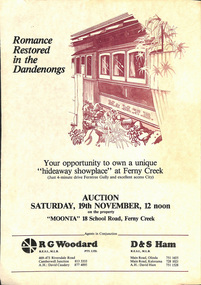
Collection of Personal Papers regarding a house built using former PMTT tramcars. Comprises: 1 - Auction notice - folded A3 light card, "Moonta 18 School Road Ferny Creek" - giving details of the property, agents, floor plan and auction date of 19/11/1983. Agents R. Woodard and D&S Ham (2 copies held) 2 - Newspaper clipping from the Progress Press with a sketch and article - "Home built from trams" 3 -"Fares please for tram treat" - Herald Sun, 24/9/1983. 4 -Auction notice - 21/11/1983 - property passed in. 5 - hand written note, with plan of the trams and location map - not dated 6 - set of six hand written notes recording conversations with various people regarding a house in Ferny Creek with trams, including the Public Trustee 1976 and 1977. 7 - Auction notice for "Charrawalla" - School Road, Ferny Creek dated 7/5/1977 from The Age. Not all items numbered, See also Reg Item 1356, 1833 and 1518 for related items.trams, tramways, mmtb, pmtt, ferny creek, tramcars, melbourne, houses, sale of land -
 Melbourne Tram Museum
Document - Informaion booklet / folder, The Met, "The Met", late 1980s
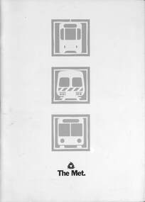
Information document about The Met, its services, forward plans, trams, trains, buses. Includes maps showing where upgrades were planned, including roads, and electrification of rail lines. Has a forward by Kevin Shea the Managing Director of The Met. Undated, late 1980s, based on the text with some dates. Has a photo of B2 class tram No. 2005. Notes the completion of the Hong Kong project in 1988.Provides infomation about the forward planning of The Met in late 1980s.Document - 16 pages including folded out sheet + card covers.melbourne, tramways, trams, the met, mta, railways, buses, planning -
 Melbourne Tram Museum
Drawing, Public Transport Corporation (PTC), "Existing tram & Light rail overhead route map", 1996
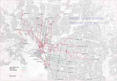
Drawings shows on a street plan of Melbourne, tram routes, route numbers location of cross overs, and track availability of pantograph only, pole only and dual running. Dated 5/6/1996Demonstrates a PTC document for detailing overhead availability and cross overs.Drawing - Document - folded A3 sheettramways, ptc, pantographs, trolley poles, overhead, cross overs, route numbers, tram routes -
 Melbourne Tram Museum
Document - Instruction Book, Yarra Trams, "New Operations Plan - Domain Interchange", 2013
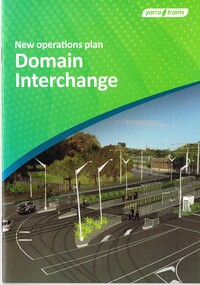
Instruction book - 20 pages, printed on gloss paper, full colour, A5 centre stapled titled "New Operations Plan - Domain Interchange", outlining the change to the Domain Junction tram stop and track arrangements, that were built during March and April 2013. Has a table of contents, map, summary of changes, stop features, operations plan for St Kilda Road and Route 55 service, arrangements while being built, and general rules. Signed by Dennis Griffiths, Director of Operations.trams, tramways, yarra trams, domain junction, route 8, route 55, road works, st kilda rd, tram stops -
 Melbourne Tram Museum
Document, Engage Victoria, Footscray and Maribyrnong Tram Corridor Planning _ Engage Victoria, July 2024
Digital document from Engage Victoria looking at options and feedback for possible changes to the Route 82 route in Maribyrnong and Footscray areas for the introduction of low platform stops in Gorden St and Droop St. Includes a map for proposed stops and existing stops. The document notes that funding for stop upgrades is part of a future budget process.Demonstrates a Consultative document by Engage Vic. August 2024.Digital document - 11 pagestramways, platform stops, footscray, maribyrnong, route 82, consultation -
Melbourne Tram Museum
Document, Engage Victoria, Route 86 Tram Corridor Planning _ Engage Victoria, April 2024
Digital document from Engage Victoria looking at options and feedback for possible changes to the Route 86 route in Fitzroy and Northcote areas for the introduction of low platform stops in Gertrude, High and Smith Sts. Includes a map for proposed stops and existing stops. The document notes that funding for stop upgrades is part of a future budget process.Demonstrates a Consultative document by Engage Vic. April 2024.Digital document - 10 pagestramways, platform stops, consultation, route 86, fitzroy, northcote, smith st, gertrude st, high st -
 Melbourne Tram Museum
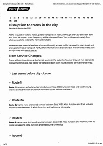
Ephemera - Timetable, Public Transport Victoria (PTV), "Disruption to trams in the City", 17/09/2021 12:00:00 AM
Set of four documents associated with a planned major Demonstration over COVID-19 lockdowns planned to be held in the city on Saturday 18/9/2021. The actual event took place outside Richmond Town Hall and then in Barkers Road Hawthorn. News stories of the night did show some trams were caught up in the event. .1 - set of 5 pages printed from the Yarra Trams website showing changes route by route and a map. .2 - set of 6 sheets from the PTV website including Metro Trains and regional services. Note many VLine crews were impacted by a COVID outbreak and were isolating. .3 - Yarra Trams Employee Notice Y21653 - digital image copy only .4 - Map of the event - digital image.trams, tramways, covid-19, timetables, tram services, events -
 Melbourne Tram Museum
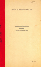
Document - Report, Melbourne & Metropolitan Tramways Board (MMTB), "Chapel Street - Tram Routes - Data Sheets - Stop by Stop survey 1972", Dec. 1972
Report - Foolscap, card covers, red tape binding, 10 pages, titled "Chapel Street - Tram Routes - Data Sheets - Stop by Stop survey 1972" Maps running times and summary including a check across conductors journals. Dated Dec 1972, notes work done by L Hogan, W. TootellHas "Lees" in the top right hand corner and the title on the left side of the report.trams, tramways, routes, passengers, planning, development, chapel st -
Canterbury History Group
Document - Frognall - History, Royal Australian Air Force
Photocopy of a 38 page booklet compiled by Royal Australian Air Force Engineers Cadet Squadron , includes maps, house floor plan, photographs and footnotescanterbury, royal australian air force engineers cadet squadron, hicks> clarence, laycock> burdett, frognall, mont albert road, maps, elgar's special survey -
 Melbourne Tram Museum
Document - Report, Graeme Breydon, "Future Development of Tramways in the Melbourne Central Business District", Apr. 1973
Six paged duplicated paper or report titled "Future Development of Tramways in the Melbourne Central Business District", by Graeme Breydon, presented to the AETA 1973 Convention, based on an article prepared for the August 1972 issue of Electric Traction. Has references, looks at proposals for underground part of the Swanston St tramway, alternatives for flinders St and a Yarra crossing, St Kilda Road issues, William St, CBD problems and travel issues, shortcomings of proposals, alternatives, Flinders Gate interchanges, associated track improvements, cost benefit ratios, comments and conclusions. 2nd copy contains within a brown manila quarto sized folded marked "Tramways in the Melbourne. Central Business District" G. Breydon (Aug. 1972). See also Reg Item 3069 and 2812 for further references. .2 - letter - c Jan 1973 - carbon copy of a Letter to the Editor for response to a letter in Electric Traction Dec. 1972 responding to H. Moses and making specific comments. .3 - letter - 29/1/1973 to Graeme Breydon from the Ian Cooper of the AETA responding and accepting an offer of Graeme to present on the Board's plan for the forthcoming AETA Canberra Conference in April 1972. .4 - Report - 17 Quarto pages, stapled on the left hand side titled "Future Development of Melbourne Tramway System, with particular reference to possible improvements to the fixed plant of the Central Business District", written by Graeme Breydon, dated Jan. 1972. Refers to the 1962 report of Risson, and scheme presented to Council, Has hand drawn maps of the central area of Melbourne, Looks at the background, traffic issues, proposed underground loop, employment distribution, an extension to Elisabeth St, reversing loops, St Kilda Road and comments on the MMTB proposals. Refers to a paper delivered by D Lees, MMTB Planning Engineer, Swanston St underground proposal,on outside of the 2nd copy, and on top right hand corner of paper AETA Library mark "4E11"trams, tramways, mmtb, melbourne, traffic control, swanston st, st kilda rd, elizabeth st, bourke st, aeta, transportation, underground tramways -
 Melbourne Tram Museum
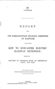
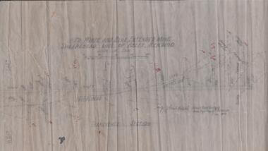
Document - Report, Victorian Parliament, "Report - The Parliamentary Standing Committee on the Proposed Kew to Doncaster Electric Railway Extension", Dec. 1930
Printed - 12 page foolscap, stapled on left hand side, 2 sections, Victorian State Parliamentary Report titled "Report - The Parliamentary Standing Committee on Railways on the Proposed Kew to Doncaster Electric Railway Extension", together with minutes of evidence, book of reference, plan and map, dated 4/12/1930. References a 1928 document, looks at construction costs, sites for railway stations, estimated revenue and expenditure, existing Kew line financials, town planning, bus services, MMTB input, tram services, alternatives, committee views, recommendations and a map of proposed routes, showing roads and tram services. Includes references to the Kodak estate and APM proposals at Fairfield. See Reg Item 2102.3 for the 1928 report.trams, tramways, doncaster, railways, public transport, kew -
 Melbourne Tram Museum
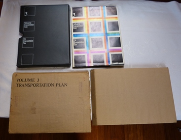
Document - Report, The Metropolitan Transportation Committee, "Melbourne Transportation Study - The Transportation Plan - Volume 3", 1969
Report titled "Melbourne Transportation Study - The Transportation Plan - Volume 3", presented in a black vinyl covered slip case, paper cover, bound, sewn with end papers, fold out maps, 74 pages. Each sheet within the report has rounded edges. Contained within a printed cardboard packing case. Includes many tables, graphs, charts and coloured sheets. Report prepared by The Metropolitan Transportation Committee - 1969, looking at the planning of all forms of transport for Melbourne with a timeframe of 1985. Chaired by Vernon Wilcox, Minister of Transport. Included Robert Risson - Chairman of MMTB. Set the basis for a very extensive freeway system that was only partly followed. Includes trams, trains (city loop), buses, parking, travel and population predictions, costs and implementation.Has numerous AETA stamps throughout the book. Inside front cover and on packing case "A12" in red ink.trams, tramways, melbourne, road transport, tramways, railways, public transport, transportation plan -
 Melbourne Tram Museum
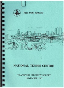
Document - Report, Dennis Johnston and Associates, Road Traffic Authority, "National Tennis Centre - Transport strategy Report November 1987", 1987
Report - 35 pages, within light blue covers, comb bound with black binder, titled "National Tennis Centre - Transport strategy Report November 1987". Report looks at the then planned Tennis Centre precinct and use of public transport in order to access it. It includes coach and car parking and how to handle various modes. Includes the MCG carpark, maps, parking areas, walking paths, access points. At the time, the tram line was located in Batman Ave. Also includes notes on the public information campaigns. Produced with the assistance of the MTA. Report prepared by Dennis Johnston and Associates for the Road Traffic Authority.trams, tramways, public transport, tennis centre, melbourne, mta -
 Melbourne Tram Museum
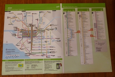
Poster, Yarra Trams, "Melbourne Tram Network" and "Routes from this Stop", Dec. 2012
Full colour poster printed on a vinyl plasticized based sheet, titled "Melbourne Tram Network" - showing a diagrammatic layout of Melbourne tram routes, Myki ticket notes and where tickets can be obtained, information numbers (PTV, phone applications) and information on Tram Tracker, twitter and other contact systems on the left side. On the right side titled "Routes from this Stop" is the information and detailed plan of every stop on routes 3, 3a, 16 and 96, including buses and train stop and connecting tram services. Printed for Stop 136, The Esplanade. Map shown as effective April 2011, printed December 2012. Has the document information on the right hand side of the poster. Two copies held.trams, tramways, yarra trams, ptv, maps, tramtracker, myki, the esplanade, route 96, route 3, route 16 -
 Melbourne Tram Museum
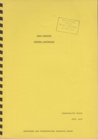
Document - Report, Melbourne & Metropolitan Tramways Board (MMTB), "East Preston Tramway Extension - Feasibility Study July 1976", Jul. 1976
Ninety three page, plus yellow covers, plastic cover on front and bound with a brown coloured comb binder report titled "East Preston Tramway Extension - Feasibility Study July 1976", by the MMTB. Looks at the costs, construction, operating cots, revenue, proposals considered and patronage for the extension of the East Preston tramway in various stages. Has a number of maps, figures, tables, plans, property acquisition, extension to Preston Institute of Technology, road layouts, bus routes and analysis of costs.Stamped on cover and inside page "Discarded from PTC Library 19 Oct 1989".trams, tramways, east preston, mill park, latrobe university, tramway proposals, mmtb -
 Melbourne Tram Museum
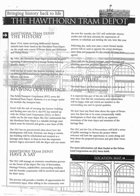
Document - Report, Minister of Transport, "Bringing history back to life - The Hawthorn Tram Depot", Aug. 1998
Report - consultation document titled - "Bringing history back to life - The Hawthorn Tram Depot", 7 A4 sheets, photocopied, outlining the joint Public Transport Corporation (PTC) and Urban Land Corporation (ULC) study into the future of the Hawthorn Tram Depot. Includes a site plan or location map, consultation proposals, news release from the Minister for Transport - Mr Robin Cooper - dated 12/8/1998 and background document providing details of some of the heritage trams - both the PTC and the TMSV. Two copies held - one stapled. Imaged as a pdf file.trams, tramways, hawthorn depot, heritage, minister for transport, tram depot -
 Ringwood and District Historical Society
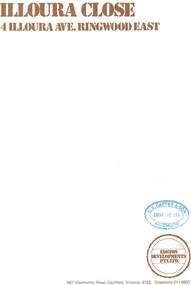
Document - Sales Brochure, "Illoura Close" 4 Illoura Avenue, Ringwood East, Victoria. Circa 1970s
Folded brochure advertising sale of ten Group Housing Project properties, with list of features, site plan, location map, and typewritten summary of house sizes and prices. Edston Developments Pty. Ltd., 967 Glenhuntly Road Caulfield, Victoria, 3162. Telephone 211 6937. Architects: Clive Fredman and John Malina - 880 Toorak Road, East Hawthorn. Accompanying handwritten notation by Richard Carter R.E.S.I. - "Illoura Close (is) one of the few developments in Ringwood under the Cluster Titles Act". -
 Bendigo Historical Society Inc.
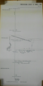
Document - MARKS COLLECTION: NEW CHUM LINE OF REEF MAP
Plan (copy) of New Chum Line of Reef. Plan has been copied in two sections. On top of plan 'Underground survey of mines Sandhurst, New Chum Line of Reef', plan shows longitudinal and cross section views of the workings on the reef. Shaft No. 76 marked. Datum line on top indicates 750' above sea level, on bottom of plan, bottom of shaft 2022.24 below sill. Drawn by Arthur Everett, Mining Department, Melbourne, 1884.bendigo, mining, new chum line of reef -
 Bendigo Military Museum
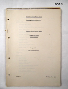
Administrative record - Royal Australian Survey Corps Planning Conference 1972 - Standard of Compilation sheets by Army Survey Regiment, Army Survey Regiment, Bendigo, 03.10.1972
This booklet was prepared for the Royal Australian Survey Corps Planning Conference 1972 by the Army Survey Regiment held at Fortuna Bendigo. It was intended to provide a trouble shooting guide for personnel engaged in the production of map compilation sheets. See also item Number 6517 "Standard of Compilation Sheets" by LtCol DR Ridge (RASvy)26 x A4 page document containing typed text diagrams and copied map extracts, photocopies and Oza film. Item is four hole puched and is held together by an ARNOS Fastenerroyal australian survey corps, rasvy, fortuna, army survey regiment, army svy regt, asr -
 Bendigo Historical Society Inc.
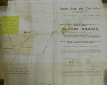
Document - MARKS COLLECTION: BOUNDY'S FREEHOLD GOLD MINES MALMSBURY
Plan/advertisement 1888 for the sale of the Boundy's Freehold Gold Mines Malmsbury, 260 acres of auriferous and arable freehold land. Document contains map of mines, names include O'Connors Freehold Company, Egyptian Company, Queen's Birthday Company, No.1 South Queen Company, Madam O'Connor's company, Extended South Queen's Birthday Company. Scale 10 chains to one inch. Taken from Mr. H. Archdale's Plan by Walter Sleeman, Mining Mgr., Oct 9th. 1888. On RH side of map Daylesford Road to Malmsbury marked. The land is only about two miles from the Malmsbury railway station. On back of document letter from Henry Nutman, Mining Manager, Queens Birthday Company; Report on Plan Walter Skleeman, M.M.; letter to S. Deeble, 35 Queen St., Melbourne with report on mine from George Jenkyn and Mining Manager's Report in Argus 24th.October 1888.mine, gold, boundy's freehold gold mine -
 Bendigo Historical Society Inc.
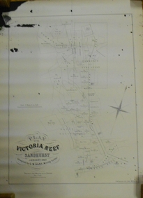
Document - MARKS COLLECTION: MAP OF VICTORIA REEF MINING CLAIMS
Copy of map. On bottom LH side: Plan of the Victoria Reef Sandhurst January 1867, Compiled by G.W. Hart, Mining Surveyor. Published by John N. Macartney, Argus Agent, Sandhurst. Price 4/- each. On bottom Rh side J.W. Pearson & Co. Lith. Melbourne Plan shows mining claims and names of holders, scale (4 chains to one inch) Loddon Road, Mount Korong Road, Ironbark Gully, township of Long Gully, Quartz Miners' Arms and Gold Mines Hotel on Loddon Road.bendigo, mining, victoria reef plan -
 Bendigo Historical Society Inc.
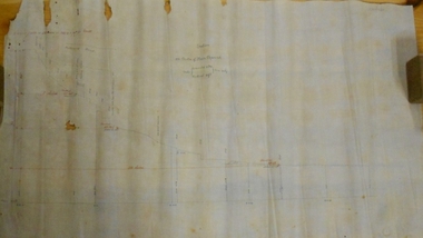
Document - MARKS COLLECTION: SECTION OF MAIN CHANNEL
Plan drawn on waxed type paper, fragile. Written in centre of map 'Section on Centre of Main Channel, Scale horizontal 2 chs, vertical 10ft., to an inch'. Plan shows Melbourne Road on top section. Written in red ink '5,000,000 galls in 24 hours = 3472.2 gals per minute'. Plan located in documents from George Lansell auction.bendigo, mining, water channel section -
 Bacchus Marsh & District Historical Society
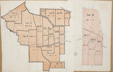
Map, Glenvale Estate and Glenmore Estate Land Sales 1909
The two land auction plans shown in this record relate to the sale of land from the Glenmore Estate property. The Glenmore property was established by C.J. (Charles James) Griffith and James Moore around 1840. Moore sold his interest to Moelesworth Greene in 1848. Greene was the nephew of the other owner Charles Griffith who died in 1863. From around the 1870s onwards parts of the Estate were subdivided and put up for sale or lease. In subsequent decades more changes in ownership occurred. These two plans document another major sale of the land from the original Glenmore Estate including part of the estate which had become used for dairy farming and was at that time known as the Glenvale Estate. Two single page maps pasted together on a single page of a bound volume of maps. One map shows 15 separate lots of land for sale. The other map which has the words 'Glenvale Estate' at the top of the map shows 4 lots of land for sale. Both parcels of land were originally part of the Glenmore Estate a pastoral holding belonging to C.J. Griffith and James Moore which the began in the Rowsley area south west of Bacchus Marsh in the 1840s. The maps are pasted into a bound volume containing 76 maps or plans in total. High resolution digital image stored on BMDHS computer network. bacchus marsh victoria maps, glenvale estate property, glenvale estate land sales, glenmore estate, glenmore station -
 Bendigo Historical Society Inc.
Map - RED WHITE & BLUE EXTENDED - PLAN OF RED WHITE AND BLUE EXTENDED MINE TRANSVERSE SECTION
Transverse section of the Red White & Blue Extended Mine on the Sheepshead Line of Reef showing shafts, depths and geological features. Drawn on tracing film in pencil. Signed by J J Caldwell, District Field Geologist, Mines Department, Bendigo and dated 5/12/1940. Notes prepared by Albert Richardson.document, gold, red white & blue extended, red white & blue extended, plan of red white & blue extended mine transverse section, j j caldwell, mines dept bendigo -
 Bendigo Historical Society Inc.
Document - VICTORIA HILL - VISITOR PLANS FOR VICTORIA HILL
Handwritten carbon copy and typed copy of notes on 1st and 2nd stage plans for a tourist area on approx. 20 acres at Victoria Hill. First stage was to clean up the area, locate and sign post shafts, engine beds, etc and prepare a topographical map with these features on it. Second stage was to arrange for the purchase of typical miners homes and shops in the vicinity to be restored for inspection by visitors. Mining equipment to be placed in the area. Prepare brochures for sale. Set up a mining museum.Prepare an area near BCV 8 with direction finder to mining and general features, as this has the best natural ground level view in the City. Notes prepared by Albert Richardson.mine, gold, victoria hill, victoria hill, visitor plans for victoria hill, darrel mcclure, bendigo city council, bendigo historical society, central nell gwynne, caleb thomas, bcv 8, lazarus, old chum, new chum, victoria, repeater station (p. m. g.) -
 Ringwood and District Historical Society
Document - Real Estate Folder, Savernake Estate, Ringwood, Victoria - Stage one - 1967
Plan of Subdivision, Part of Crown Allotment 31A and advertisement for sale of residential allotments with map showing layout of subdivision. Typewritten pricelist attached outlining suggested terms of sale as of 14 September, 1967.Subdivision includes Evelyn Road, Cameron Road, Klead Court, and San Remo Road. Agent - C.E. Carter & Son., 126 Whitehorse Road, Ringwood. (Phone) 87-6024, 87-6830, 870-2519, After hours: 723 3298, 878 2648. Subdivision Plan stamped Donald Cameron Consultants Pty. Ltd., Consulting Engineers, 472 Bourke Street Melbourne - 67-2602. -
Moorabbin Air Museum
Document (item) - Cierva C30 gyrocopter 5 WW2 photos of Soldiers on parade WW1 photo of Soldiers in trench accommodation near Ypres Wackett bomber schematic Boeing Vertol helicopter Poster of Sunderland short 201 squadron listing of CAC technical publications outline of CAC aircraft over 46 year mfr poster of the sabre aircraft family Plan of CAC lorimer st plant ordinance maps of: Ringwood area Korumburra Woolamai Western port lots of acid free paper Richthofen duelling with Major Hawker Nov 1916 Jimmy Doolittle first blind flight 1929 1914 Max Immelmann flying over Paris Sept 1917 Werner Voss in battle with S.E 5's June 1915 Warneford shoots down Zeppelin 1918 Willy Coppens collides with Zeppelin Oct 1918 William barker duels with 60 German planes May 1918 Edward Mannock outwits German planes July 1915 Nungesser flying Voisin bomber ohn Robertson Duigan and his Duigan Biplane Iroquois rescue Poster CT-4A airtrainer Ansett aircraft since 1920 Poster Nomad N22B mission master Commuter Qantas aircraft story Hawker De Havilland 60 years of aircraft FA 18 schematic Poster Bushrangers Iroquois Vietnam RAAF Poster Sopwith Snipe Albert Packer Poster, Soldiers in uniform Gyrocopter Posters Aircraft history Ordinance maps
-
Lakes Entrance Historical Society
Book, Orbost Historical Society Inc, Barns of the Snowy River Orbost, 2006
Documents the distinctive slatted barns of the Lower Snowy River, Orbost, Victoria. Includes sketch maps, barn plans, history of area and families and personal ineterviews.Ngaire Donald May Leatchland settlement, agriculture, natural disasters, transport -
 Ballarat Tramway Museum
Administrative record - Book, Andersons' printing, "Ballaarat Tramways", Jan. 1888
Book with an index or table of contents, listing all the documents relating to the establishment of the Ballaarat Tramways (the horse tram operator) including, references to Legislation and orders in council, original tender conditions, the contract between the Council and Edward Thomson, Specifications for the construction, delegation to the operator, and plan of routes. Last document dated 17/1/1888.Yields information about the establishment of the Ballarat horse trams, Councils and the operator.Bound book, with end papers, 20 pages, patterned covers, titled with a label on the front cover - "Ballaarat Tramways"Has an old ownership note on the inside front cover.secv, tramways, horse trams, city of ballaarat, ballaarat tramway company, tenders, specifications, operations, maps -
 Ringwood and District Historical Society
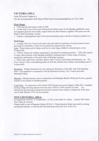
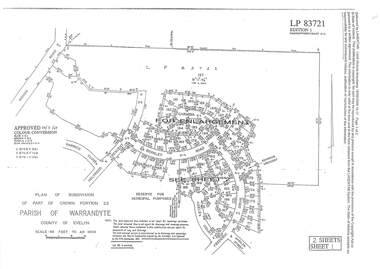
Document - Subdivision Plan, LP83721 Part of Crown Portion 23, Parish of Warrandyte, County of Evelyn, Vol 8708 Fol 351, Vol 8745 Fol 148 and Vol 8751 Fol 034 - 1969
Double sided LANDATA Land Victoria 2-sheet plan printout dated 2009Sheet 1 map and Sheet 2 enlargement including Wonga Road, Holyrood Crescent, Harwick Close, Berkley Road, Frederic Drive, Kenwood Crescent, Adele Court and Marilyn Street, Ringwood. Markings also include LP83722 .