Showing 1049 items
matching earth
-
 Glenelg Shire Council Cultural Collection
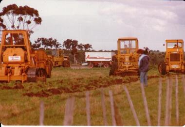
Slide - Slide - Cashmore Airport, Portland, 1980s
Coloured slide. Piece of earth moving equipment working on side of runway site. Two other workmen. Wooden pole in foreground with black rubber hose wrapped around it.portland airport, cashmore airport, air travel, portland -
 Hume City Civic Collection
Photograph, 1/08/1978
On 4th of August 1978 work began on the construction of the Goonawarra Estate on land that was the former Goonawarra Farm which overlooked the town of Sunbury abnd the Jacksons Creek valley. Plans for the new development included a golf course, houses, community and recreational facilities.The golf course openrd in 1980 and housing construction continued throughout the last two decades of the twentieth century and into the twentieth first century.A coloured photograph of the first sod being turned at the Goonawarra Estate. Four large pieces of earth-moving machinery and a large semi-trailer are in picture. A man is standing in the foreground.goona warra golf club, goonawarra farm, goonawarra housing estate, housing developments, sharkey, robert b., killkenny homes, australian ideas homes pty.ltd., craftsmen homes., glamor homes, villa bella homes, george evans collection -
 Wodonga & District Historical Society Inc
Album - Hume Reservoir Australia Album - Core wall with drainage tunnel and earth embankment in progress in Victoria, June 1924, 1927
This set of photos is from a leather bound album bearing the inscription "HUME RESERVOIR AUSTRALIA" plus 'The Rt. Hon. L. C. M. S. Amery, P. C., M .P.' all inscribed in gold. It was presented to The Rt. Hon. L. C. M. S. Amery, P. C., M. P, Secretary of State for Dominion Affairs on the occasion of his visit to the Hume Reservoir on 2nd November 1927. This album is of local and national significance as it documents the planning and development of the Hume Reservoir up to 1927. It was the largest water reservoir in the British Empire. The album records the pioneering engineering work that went into its construction.DEPARTMENT OF PUBLIC WORKS, N.S.W. RIVER MURRAY WATERS SCHEME. HUME RESERVOIR. 14. Core wall with drainage tunnel and earth embankment in progress in Victoria, June 1924.hume reservoir australia, river murray waters scheme, hume reservoir construction -
 Falls Creek Historical Society
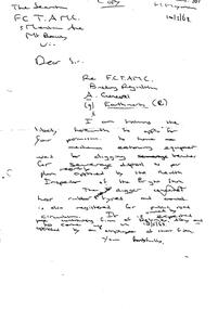
Letter - FCTAMC Building Regulation (A) General Earthmoving (B), 10.05.1963
Bob (Herman) Hymans (a former member of the Royal Netherlands Navy) was born in Bloemendaal, Holland on 30th September 1922. During World War II he fought against the Japanese in the Dutch East Indies (now Indonesia) and was imprisoned in Changi and on the Burma Railway. After gaining qualifications as a Ski Instructor, Bob arrived in Falls Creek in July 1950. Working as an Instructor and Supervisor at Bogong Lodge, Bob decided his future was in accommodation. He was successful in negotiating an indenture for land from the State Electricity Commission (SEC). It took Bob two years to build his Grand Coeur Chalet but, tragically, it was burned down in August 1961. Bob also built the first Chairlift in Australia. This was a single chairlift and the structure was built from wooden electricity poles. He was constantly full of new ideas and proposals for the village. Bob Hymans die on 7th July 2007. This Collection of documents and letters tells the story of Bob's endeavours to develop Falls Creek into the ski village it is today.This letter is significant because it reflects the relationship between Bob Hymans and the Management Committee.A handwritten letter from Bob Hymans to the Falls Creek Tourist Area Management Committee requesting permission to use mechanical earth moving equipment to did trenches for sewerage disposal.falls creek tourist area management committee, bob hymans, falls creek administration -
Glenelg Shire Council Cultural Collection
Slide - Slide - Construction Portland / Cashmore Airport, c. 1980
Vern Mc Callum CollectionColoured slide. Trench. Sky visible, top rear. Also bottom section of earth moving equipment, top edge of trench, left rear. Piles of dirt, pieces of timber, in trench. -
 Bendigo Historical Society Inc.
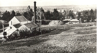
Photograph - MINE SITE
Black and white photograph of the Hustler's Mine as a part of the Bendigo mining landscape with the valley in the background. On the left hand side is the poppet head, chimney and mining sheds and in the foreground is the bare stony earth.bendigo, mining, hustler's royal reserve mine, bendigo, mines and mining, mines, mining, gold mining, gold, gold mines, place, bendigo mines -
Port Melbourne Historical & Preservation Society
Book, Ian McFarlane et al, "My Heart is Breaking", 1993
"My Heart is Breaking" - A Joint Guide to Records about Aboriginal People" in the PROV and the Australian Archives. A4, earth tones, with photo of Susan from the Gippsland tribe, with baby. 192 pagesaustralian aborigines, public record office victoria, australian archives -
Tatura Irrigation & Wartime Camps Museum
Photograph, Alan Whiting, 1924
Taken for the Victorian State Rivers and Water Supply Commission.Mounted medium sized black and white photograph. Waranga Basin earth wall concrete reinforced (middle of picture) / Tree and hut near water filled borrow pits right centre.irrigation, victorian state rivers and water supply commission, waranga basin -
Tatura Irrigation & Wartime Camps Museum
Photograph, Alan Whiting, 1924
Taken for the Victorian State Rivers and Water Supply Commission.Mounted medium sized black and white photograph. Waranga Basin outlet structure and regulator / Concrete arches and pylons / Steel handrails / Rock and earth fill walls either side of channel.irrigation, victorian state rivers and water supply commission, waranga basin -
Tatura Irrigation & Wartime Camps Museum
Photograph, Goulburn Weir, 1890
Taken by photographer for State Rivers and Water Supply Commission.Medium sized black and white photograph. Earth and rubble bank bottom right corner - Concrete spillway and platform - overflow water in foreground - Trees on horizon - Dwelling left middle distancevictoria state rivers and water supply commission, goulburn weir -
Tatura Irrigation & Wartime Camps Museum
Photograph, Cattanach Canal, 1957
Taken by the photographer for Victoria State Rivers and Water Supply Commission.Large sepia photograph - Concrete structure, side wings, three centre supports, platform and framework above. Man standing, looking up from base. Cracked earth floor and embankment.Above photo: "Cattanach Canal / Regulator on Connection to No.1 Main Channel"irrigation, victoria state rivers and water supply commission, cattanach canal -
 Ballarat Tramway Museum
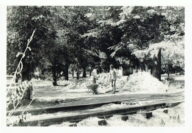
Photograph - Black & White Photograph/s, Campbell Duncan, c1973
Yields information with the construction of the BTPS depot prior to power being connected and has a strong association with the people in the photograph.Black and white photograph shovelling earth into a wheel barrow during the construction of the depot - possibly c1973. Possibly Graeme Jordan and Richard Gilbert. Level crossing in the foreground. Printed on AGFA paper.trams, tramways, btps, museum -
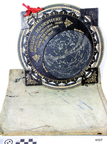 Flagstaff Hill Maritime Museum and Village
Planisphere, Early 20th Century
The word Planisphere (Latin planisphaerium) was originally used in the second century by Claudius Ptolemy to describe the representation of a spherical Earth by a map drawn in the plane. This usage continued into the Renaissance: for example Gerardus Mercator described his 1569 world map as a Planisphere. The word describes the representation of the star-filled celestial sphere on the plane. The first star chart to have the name "Planisphere" was made in 1624 by Jacob Bartsch. Bartsch was the son-in-law of Johannes Kepler, discoverer of Kepler's laws of planetary motion. A significant item of celestial mapping used by marine navigators This particular item was made and used in the first quarter to half of the 20th centuryPlanisphere of northern hemisphere, with canvas bag. Planisphere consists of a circular star chart attached at its centre to an opaque circular overlay that has a clear elliptical window or hole so that only a portion of the sky map will be visible in the window or hole area at any given time. The chart and overlay are mounted so that they are free to rotate about a common pivot point at their centres. The star chart contains the brightest stars, constellations and (possibly) deep-sky objects visible from a particular latitude on Earth. The night sky that one sees from the Earth depends on whether the observer is in the northern or southern hemispheres and the latitude. A Planisphere window is designed for a particular latitude and will be accurate enough for a certain band either side of that. Planisphere makers will usually offer them in a number of versions for different latitudes. Planispheres only show the stars visible from the observer's latitude; stars below the horizon are not included. A complete twenty-four-hour time cycle is marked on the rim of the overlay. A full twelve months of calendar dates are marked on the rim of the starchart. The window is marked to show the direction of the eastern and western horizons. The disc and overlay are adjusted so that the observer's local time of day on the overlay corresponds to that day's date on the star chart disc. The portion of the star chart visible in the window then represents (with a distortion because it is a flat surface representing a spherical volume) the distribution of stars in the sky at that moment for the Planispheres designed location. Users hold the Planisphere above their head with the eastern and western horizons correctly aligned to match the chart to actual star positions. "Made in Germany for GEORGE PHILIP & SONS Ltd. Geographical and Educational Depot, 32 Fleet Street, London" Canvas bag has "Capt. H (Howard) Tyler from Captain H. F. Woolf" "Tyler 22 ? St East Brighton" also "13 Halls St Flinders"flagstaff hill, warrnambool, shipwrecked-coast, flagstaff-hill, flagstaff-hill-maritime-museum, maritime-museum, shipwreck-coast, flagstaff-hill-maritime-village, planisphere, star map, marine navigation, maps, george philip & sons -
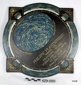 Flagstaff Hill Maritime Museum and Village
Planisphere, Early 20th Century
The word Planisphere (Latin planisphaerium) was originally used in the second century by Claudius Ptolemy to describe the representation of a spherical Earth by a map drawn in the plane. This usage continued into the Renaissance: for example Gerardus Mercator described his 1569 world map as a Planisphere. The word describes the representation of the star-filled celestial sphere on the plane. The first star chart to have the name "Planisphere" was made in 1624 by Jacob Bartsch. Bartsch was the son-in-law of Johannes Kepler, discoverer of Kepler's laws of planetary motionA significant item of celestial mapping used by marine navigators This particular item was made and used in the first quarter to half of the 20th century.Planisphere consists of a circular star chart attached at its centre to an opaque circular overlay that has a clear elliptical window or hole so that only a portion of the sky map will be visible in the window or hole area at any given time. The chart and overlay are mounted so that they are free to rotate about a common pivot point at their centers. The star chart contains the brightest stars, constellations and (possibly) deep-sky objects visible from a particular latitude on Earth. The night sky that one sees from the Earth depends on whether the observer is in the northern or southern hemispheres and the latitude. A Planisphere window is designed for a particular latitude and will be accurate enough for a certain band either side of that. Planisphere makers will usually offer them in a number of versions for different latitudes. Planispheres only show the stars visible from the observer's latitude; stars below the horizon are not included. A complete twenty-four-hour time cycle is marked on the rim of the overlay. A full twelve months of calendar dates are marked on the rim of the star chart. The window is marked to show the direction of the eastern and western horizons. The disc and overlay are adjusted so that the observer's local time of day on the overlay corresponds to that day's date on the star chart disc. The portion of the star chart visible in the window then represents (with a distortion because it is a flat surface representing a spherical volume) the distribution of stars in the sky at that moment for the Planispheres designed location. Users hold the Planisphere above their head with the eastern and western horizons correctly aligned to match the chart to actual star positions. "Sold by J DONNE & SON, Booksellers & Stationers, 349 Post Office Place Melbourne 349. Admiralty Chart Agents" and " Made in Germany for George Philip & Son Ltd" England . Signature "Capt E. B. ?..id, 22 Baund St"flagstaff hill, warrnambool, shipwrecked-coast, flagstaff-hill, flagstaff-hill-maritime-museum, maritime-museum, shipwreck-coast, flagstaff-hill-maritime-village, star map, marine navigation, maps, george philip & sons -
Tatura Irrigation & Wartime Camps Museum
Photograph, 1910
Taken by photographer for State Rivers and Water Supply Commission.Small black and white photograph. Earth embankment level being raised with clay hauled in scoops up the trestle ramp by horse-powered cable and pulleys. Workmen foreground right. Waranga reservoir. goulburn weir, victorian state rivers and supply commission -
Tatura Irrigation & Wartime Camps Museum
Photograph, 13/04/1918
Taken by photographer for State Rivers and Water Supply Commission.Medium sized black and white photograph. Eildon Weir / Original structure 1918 / Rock and earth fill dam wall / concrete spillway (lower left) / Water middle distance / hills beyondgoulburn weir, victorian state rivers and supply commission -
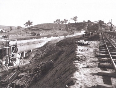
 Wodonga & District Historical Society Inc
Album - Hume Reservoir Australia Album - Foundations for core wall of earth embankment, September 1921, 1927
This set of photos is from a leather bound album bearing the inscription "HUME RESERVOIR AUSTRALIA" plus 'The Rt. Hon. L. C. M. S. Amery, P. C., M .P.' all inscribed in gold. It was presented to The Rt. Hon. L. C. M. S. Amery, P. C., M. P, Secretary of State for Dominion Affairs on the occasion of his visit to the Hume Reservoir on 2nd November 1927. This album is of local and national significance as it documents the planning and development of the Hume Reservoir up to 1927. It was the largest water reservoir in the British Empire. The album records the pioneering engineering work that went into its construction.DEPARTMENT OF PUBLIC WORKS, N.S.W. RIVER MURRAY WATERS SCHEME. HUME RESERVOIR. 5. Foundations for core wall of earth embankment in New South Wales in September 1921. The River Murray in flood.hume reservoir australia, river murray waters scheme, hume weir diagrams, hume plan details -
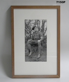 Bendigo Military Museum
Photograph - PHOTOGRAPH, FRAMED WW1, C.2008/2009
The Grinton Collection. This 38th Bn Stretcher Bearer is unidentified at this point. Refer Cat No. 1280 for Jack Grintons service details.Photograph framed. Photograph - black and white photograph on paper depicting an informal portrait of a soldier seated on an earth bank. Trees in the background. Frame - timber, light varnish finish, Perspex front, cardboard backing."Group 4: Portraiture and Remembrance". "G. Stretcher bearer of the 38th Battalion". framed accessories, camera on the somme, ww1, 38th bn, grinton -
Glenelg Shire Council Cultural Collection
Slide - Slide - Cashmore Airport, Portland, 1980s
Coloured slide. Excavated channel, running top to bottom centre of slide. Excavator working on channel background. Earth works with drain, connecting two sections of channel. Two people standing near drain.portland airport, cashmore airport, air travel, construction, development -
Glenelg Shire Council Cultural Collection
Slide - Slide - Cashmore Airport, Portland, 1980s
Coloured slide. View of narrow gutter with concrete edges both sides, north and south. Black pipe on left of gutter. Piles of grey gravel and several pieces of earth moving equipment, back left.portland airport, cashmore airport, air travel, engineering, construction, development -
 Wodonga & District Historical Society Inc
Album - Hume Reservoir Australia Album - General view of earth embankment in Victoria, October 1924, 1927
This set of photos is from a leather bound album bearing the inscription "HUME RESERVOIR AUSTRALIA" plus 'The Rt. Hon. L. C. M. S. Amery, P. C., M .P.' all inscribed in gold. It was presented to The Rt. Hon. L. C. M. S. Amery, P. C., M. P, Secretary of State for Dominion Affairs on the occasion of his visit to the Hume Reservoir on 2nd November 1927. This album is of local and national significance as it documents the planning and development of the Hume Reservoir up to 1927. It was the largest water reservoir in the British Empire. The album records the pioneering engineering work that went into its construction.DEPARTMENT OF PUBLIC WORKS, N.S.W. RIVER MURRAY WATERS SCHEME. HUME RESERVOIR. 17. General view of earth embankment in Victoria. New South Wales section of work and Township beyond. October 1924.hume reservoir australia, river murray waters scheme, hume reservoir construction -
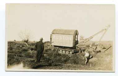 Orbost & District Historical Society
black and white photograph, first half 20th century
Ruston & Hornsby, later known as Ruston, was an industrial equipment manufacturer in Lincoln, England, the company's history going back to 1840. The company is best known as a manufacturer of narrow and standard gauge diesel locomotives and steam shovels. This photograph records early an early type of excavator used to construct drainage channels in rural Victoria.A black / white photograph / postcard of a man digging in a very large trench, probably a drainage channel, with an earth mover in the background. The machine has the name "RUSTON" on it. In the foreground is a man, dressed in a long dark coat, watching.agricultural-machinery drainage-channels ruston -
Tatura Irrigation & Wartime Camps Museum
Photograph, 1936/02
Photo taken by the photographer for Victoria State Rivers and Water Supply CommissionMedium sized black and white photograph. Eildon Reservoir spillway / Concrete structure centre / rock and earth fill dam wall top half / round concrete tower left midway along wall bank.goulburn, irrigation, photo, victoria state rivers and water supply commission, eildon, eildon weir -
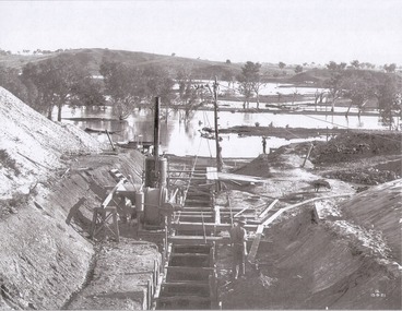
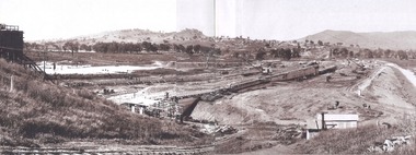
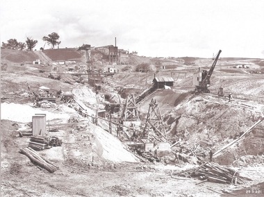
Tatura Irrigation & Wartime Camps Museum
Photograph, Goulburn Waranga Main Channel Construction, 1957
Photo taken by the photographer for Victoria State Rivers and Water Supply Commission of the Goulburn Waranga main channel in 1957.Large black and white photograph - dry mounted to cream board. Channel excavation scene with excavator in right foreground, bucket scooping earth in middle foreground, two small figures of men working mid-distance.Below photo: "Goulburn Waranga Main Channel Construction / Bucyrus 200 W. Excavator with 6 c. yd. Bucket / Looking towards off-take at Goulburn Weir / Completed Excavation in Background.goulburn, waranga, irrigation, photo, victoria state rivers and water supply commission -
 Wodonga & District Historical Society Inc
Album - Hume Reservoir Australia Album - Excavation for Foundations of Core Wall September 1922, 1927
This set of photos is from a leather bound album bearing the inscription "HUME RESERVOIR AUSTRALIA" plus 'The Rt. Hon. L. C. M. S. Amery, P. C., M .P.' all inscribed in gold. It was presented to The Rt. Hon. L. C. M. S. Amery, P. C., M. P, Secretary of State for Dominion Affairs on the occasion of his visit to the Hume Reservoir on 2nd November 1927. This album is of local and national significance as it documents the planning and development of the Hume Reservoir up to 1927. It was the largest water reservoir in the British Empire. The album records the pioneering engineering work that went into its construction.DEPARTMENT OF PUBLIC WORKS, N.S.W. RIVER MURRAY WATERS SCHEME. HUME RESERVOIR. 9. Excavations for foundations of core wall (in foreground) and part of core wall and earth embankment constructed (in background) in Victoria, September 1922.hume reservoir australia, river murray waters scheme, excavation hume reservoir -
 Warrnambool and District Historical Society Inc.
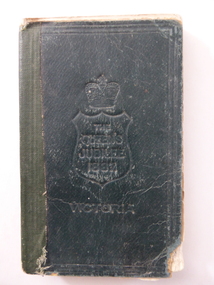
Book, New Testament The Queens Jubilee 1887, 1886
This book was printed to commemorate Queen Victoria’s Jubilee, 1887 (50th anniversary of her Coronation as Queen of England). John Markman is most likely the father or grandfather of Mary Snell (nee Markman). Mrs Snell was a teacher in Warrnambool and an active member of the Warrnambool and District Historical Society in its early years. She wrote the first book on the origin of street names in Warrnambool. Allendale is a small settlement in the Hepburn area of Victoria. This book is of minor interest as a memento of Queen Victoria’s 1887 Jubilee and as a book that appears to have come to the Historical Society via an early member, Mary Snell (nee Markman). This is a book of 240 pages. It has a black cover with the imprint on the front cover of a crown and shield and the words ‘The Queen’s Jubilee, 1887, Victoria’ and on the back cover a circular scroll with the words, ‘British and Foreign Bible Society, New Testament’. The cover has been bound with black tape and adhesive tape but the binding has come apart. Several pages are torn at the edges and dog-eared. ‘John Markman, Allendale, 17th June 1887’ Copy of Queen Victoria’s handwritten message - ‘On earth peace, goodwill toward men, Victoria, Windsor Castle, March 8,1887’ john markman, mary snell, history of warrnambool. -
 Royal Australian and New Zealand College of Obstetricians & Gynaecologists (RANZCOG)
Tin of talcum powder, 'Pears' Precipitated Fuller's Earth', A & F Pears Ltd, c1900-1920s
Unopened tin of talcum powder. Top of tin carries an image of a nurse with a baby on their knee. Tin label is entitled 'PEARS' PRECIPITATED FULLER EARTH'. The tin has a paper seal with a string - the string is pulled to break the seal. -
Tatura Irrigation & Wartime Camps Museum
Photograph, 1936
Photo taken by the photographer for Victoria State Rivers and Water Supply CommissionMedium sized black and white photograph. Eildon Reservoir dam wall / rock and earth fill wall from above / round concrete tower lower left / water above right / tree covered hill topgoulburn, irrigation, photo, victoria state rivers and water supply commission, eildon, eildon weir -
Tatura Irrigation & Wartime Camps Museum
Photograph, Goulburn Weir, 1890
Taken by photographer for State Rivers and Water Supply Commission.Medium sized black and white photograph. Concrete and iron weir structure, stone spillway, earth bank on West bank below brick control house. Dead trees in water beyond weir, houses on West bankgoulburn weir, victorian state rivers and supply commission -
 Nillumbik Shire Council
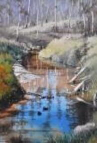
Painting: Walter MAGILTON, Walter Magilton, Sunlight and Shadows, Warrandyte, 2011
Walter Magilton's professional painting career is highlighted by numerous solo exhibitions, five of which have been in Great Britain. He has also won countless prizes, which include many 'Best in Show' awards. Walter is represented in a great number of private and corporate national and international collections, including ART Bank, in approximately twelve countries.This painting is a one of a series of approximately eight works of the river at Warrandyte and the local creeks, with particular emphasis on the reflections in the water and of the wattle growing along the banks. I was particularly inspired by Penleigh Boyde who did similar work while living in Warrandyte in the early 1920s.'Sunlight and Shadows, Warrandyte' is an oil on canvas painting depicting the Warrandyte landscape, featuring a winding creek with beautiful reflections cast upon it. The colour palate comprises muted green and earth tones, with a vivid aqua for reflective water.walter magilton, nillumbik, warrandyte