Showing 12751 items
matching estate
-
 Kew Historical Society Inc
Plan - Subdivision Plan, Mount Ida Estate, 1925
The Kew Historical Society collection includes almost 100 subdivision plans pertaining to suburbs of the City of Melbourne. Most of these are of Kew, Kew East or Studley Park, although a smaller number are plans of Camberwell, Deepdene, Balwyn and Hawthorn. It is believed that the majority of the plans were gifted to the Society by persons connected with the real estate firm - J. R. Mathers and McMillan, 136 Cotham Road, Kew. The Plans in the collection are rarely in pristine form, being working plans on which the agent would write notes and record lots sold and the prices of these. The subdivision plans are historically significant examples of the growth of urban Melbourne from the beginning of the 20th Century up until the 1980s. A number of the plans are double-sided and often include a photograph on the reverse. A number of the latter are by noted photographers such as J.E. Barnes.The Mount Ida Estate was a subdivision of fifty-two residential allotments bordering Tooronga Road, Leura Grove, Constance Street, and Mount Ida Avenue in Hawthorn East. The report of the sale of the Estate in The Argus (21 September) claimed that over 1,000 people attended the auction and that all allotments were sold on the day. On the other side of Constance Street, the plan identifies the ‘Eastern Recreation Reserve’ (now Anderson Park).subdivision plans - hawthorn -
 Whitehorse Historical Society Inc.
Document, Fulton Park Estate, 1970s
Real estate brochure for the sale of 49 blocks at Fulton Park Estate Blackburn South.Real estate brochure for the sale of 49 blocks at Fulton Park Estate Blackburn South. Agents: E Flintoff & Sons and K F LangReal estate brochure for the sale of 49 blocks at Fulton Park Estate Blackburn South. fulton road, blackburn south, freda court, blackburn south, lucia street, blackburn south, mira street, blackburn south, lana street, blackburn south, residential development, fulton park estate -
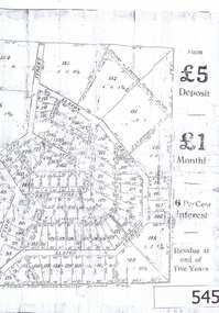
 Bacchus Marsh & District Historical Society
Map, Landsberg Estate Blackwood
The date this map was created has not been identified. It was possibly created at the time the Landsberg Estate near Blackwood was subdivided and sold into smaller lots in December 1886.Single page map showing land allotments which made up the Landsberg Estate near Blackwood. Scale 20 chains to 1 inch. The map is pasted into a bound volume containing 76 maps or plans in total. High resolution digital image stored on BMDHS computer network. bacchus marsh victoria maps, landsberg estate blackwood -
Ringwood and District Historical Society
Envelope, Sales, Auctions and Subdivisions - Pinemont Estate, Ringwood 1931
Sales, Auctions and Subdivisions - Pinemont Estate 1931 -
Stawell Historical Society Inc
Map, The Litho Co Ballarat, Glyntowyn Estate Campbells Bridge 1909, 1909
Shows Hoestead CC McCulloch ESQPaper map / Poster Advertising Subdivision of EstateMitchell Bros & White. 5003 Acres The Litho Co Ballarat Black Printing with Red Coloured Sectionsfarming -
 Whitehorse Historical Society Inc.
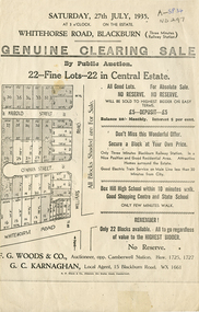
Document, Central Estate, 1935
Clearing saleClearing sale - 22 lots in Central Estate.Clearing sale g. woods & co. auctioneer, g. c. karnaghan estate agent, whitehorse road, blackburn, williams road, harold street, o'hara street -
 Kew Historical Society Inc
Plan - Subdivision Plan, Harvest Home Estate, 1919
Pru Sanderson, in her groundbreaking ‘City of Kew Urban Conservation Study : Volume 2 - Development History’ (1988), summarised the periods of urban development and subdivisions of land in Kew. The periods that she identified included 1845-1880, 1880-1893, 1893-1921, 1921-1933, 1933-1943, and Post-War Development. These periods were selected as they represented periods of rapid growth or decline in urban development. An obvious starting point for Sanderson’s groupings involved population growth and the associated economic cycles. These cycles also highlighted urban expansion onto land that was predominantly rural, although in other cases it represented the decline and breakup of large estates. A number of the plans in the Kew Historical Society’s collection can also be found in other collections, such as those of the State Library of Victoria and the Boroondara Library Service. A number are however unique to the collection.The Kew Historical Society collection includes almost 100 subdivision plans pertaining to suburbs of the City of Melbourne. Most of these are of Kew, Kew East or Studley Park, although a smaller number are plans of Camberwell, Deepdene, Balwyn and Hawthorn. It is believed that the majority of the plans were gifted to the Society by persons connected with the real estate firm - J. R. Mathers and McMillan, 136 Cotham Road, Kew. The Plans in the collection are rarely in pristine form, being working plans on which the agent would write notes and record lots sold and the prices of these. The subdivision plans are historically significant examples of the growth of urban Melbourne from the beginning of the 20th Century up until the 1980s. A number of the plans are double-sided and often include a photograph on the reverse. A number of the latter are by noted photographers such as J.E. Barnes.The ‘Harvest Home Estate’ was advertised as being a subdivision in East Kew. Now, Campbell and Owen Streets on which the allotments were located are classed as being in Kew. The Estate included 11 residential allotments abutting the Outer Circle Railway line [at the end of Owen Street]. Understandably, the vendors focused on the availability of transport by tram, noting that the Estate was near the High Street tram terminus at the Harp of Erin. A small note on the subdivision advises that the Cotham Road tram was only 3 minutes away. The location – ‘The most elevated position in lovely Kew’ – was also promoted as an advantage.subdivision plans - east kew, harvest home estate -
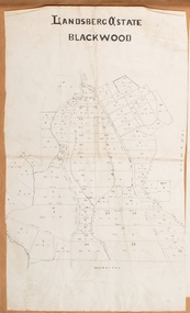
![Map, Late the Property of Robert Lawson Esq. [Landsberg Estate Blackwood]](/media/collectors/5e461d8021ea67224c82f2a1/items/67763722eb6d2cbd24dff14f/item-media/677637b7eb6d2cbd24dff29d/item-fit-380x285.jpg) Bacchus Marsh & District Historical Society
Bacchus Marsh & District Historical SocietyMap, Late the Property of Robert Lawson Esq. [Landsberg Estate Blackwood]
The date this map was created has not been identified. It was possibly created at the time the Landsberg Estate near Blackwood was subdivided and sold into smaller lots in December 1886. This land once belonged to Robert Lawson who died in 1869. Lawson was a well known school teacher who founded Scotch College in Melbourne before setting up a school near Blackwood. This map is similar to another map in the BMDHS collection titled 'Landsberg Estate Blackwood' Victorian Collections record 459 and was possibly produced at the same time.Single page map showing land allotments which made up the Landsberg Estate near Blackwood. Scale 20 chains to 1 inch. The map is pasted into a bound volume containing 76 maps or plans in total. High resolution digital image stored on BMDHS computer network. At the top of the map: 'Late the Property of Robert Lawson Esq.'bacchus marsh victoria maps, landsberg estate blackwood -
 Bacchus Marsh & District Historical Society
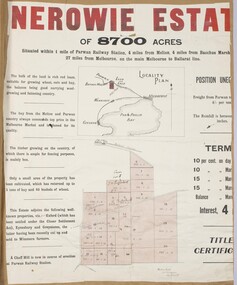
Map, Nerowie Estate Land Sale 1910
The Nerowie Estate was a large rural property of 8,700 acres (3520 hectares) near the locality of Parwan only a few kilometers east of Bacchus Marsh. It had once formed a large part of the land owned by the pioneering Staughton family.A single page paper map showing the land offered for sale from the Nerowie Estate at Parwan near Bacchus Marsh in 1910. The map is pasted into a bound volume containing 76 maps or plans in total. High resolution digital image stored on BMDHS computer network. nerowie estate parwan, land sales parwan, land sales bacchus marsh, staughton family bacchus marsh -
 Greensborough Historical Society
Advertising Leaflet, 3 Lumleah Court Greensborough, 01/01/2013
3 Lumleah Court Greensborough, 4 bedroom brick veneer home, for auction 1 December 2012, sold January 2013 for $525,000Real estate advertising leaflet, 4 p., printed in colourlumleah court greensborough -
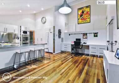 Greensborough Historical Society
Advertising Leaflet, 8 Pedersen Way Montmorency, 31/05/2012
8 Pedersen Way Montmorency. 4 bedroom, 2 storey home, private sale, sold 31/05/2012 for $803,000Real estate advertising leaflet, 4 p., printed in colourpedersen way montmorency -
 Greensborough Historical Society
Advertisement, Greenhills Estate, 1923c
The advertisement was used to sell land in the Greenhills area.The plan included details the original street lay out and names applied to them. It also has dimensions of all the blocks of land available and locations and dimensions of easements.A 2 page A3 photoccopy of a real estate advertisement. Nilgreehills, subdivision plan, greensborough -
Ringwood and District Historical Society
Envelope, Estate Agents - various plans and notes of Ringwood Subdivision
Estate Agents - various plans of Subdivision; Notes on Subdivisions -
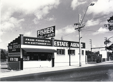 Whitehorse Historical Society Inc.
Photograph - Black and white photograph, Fisher Real Estate Agents, 1977
Black and white photo of Fisher Real Estate officesfrank fisher & co., real estate agent, blackburn -
 Kew Historical Society Inc
Plan - Subdivision Plan, Raheen Estate Subdivision, 1960
Subdivision plans are historically important documents used as evidence of the growth of suburbs in Australia. They frequently provide information about when the land was sold on which a built structure was subsequently constructed as well as evidence relating to surveyors and real estate and financial agents. The numerous subdivision plans in the Kew Historical Society's collection represent working documents, ranging from the initial sketches made in planning a subdivision to printed plans on which auctioneers or agents listed the prices for which individual lots were sold. In a number of cases, the reverse of a subdivision plan in the collection includes a photograph of a house that was also for sale by the agent. These photographs provide significant heritage information relating house design and decoration, fencing and household gardens.The Raheen Estate Subdivision of 1960 involved the creation of 36 residential allotments and the sale of 34 of these. The land on which the subdivision was created had until 1960 formed part of the grounds of the mansion Raheen in Studley Park Road. In 1917, the Catholic Church had purchased Raheen and its lands. It was to become the home of Archbishop of Melbourne, Daniel Mannix, for 46 years. The sale of the subdivision took place three years before the Archbishop’s death. Subsequent archbishops were to reside at Raheen until its sale to the Pratt family in 1981. When the sale of the Estate was reported in the newspapers in 1960, it was described as the last big subdivision near Melbourne. At the auction, 33 of the 36 allotments were sold. The auction realised £315,750. Purchasers were advised that the vendor intended to keep lots 22 and 23. The alllotments in the subdivision required the construction of new roads. These included Eamon Court and Raheen Drive. The justification provided by the Church for the sale was that the estate was being sold to finance school building projects.subdivision plans - kew, studley park, raheen estate, eamon court, studley park road, coombes avenue, raheen drive -
 Kew Historical Society Inc
Plan, Studley Heights Estate, 1936
Pru Sanderson, in her groundbreaking ‘City of Kew Urban Conservation Study : Volume 2 - Development History’ (1988), summarised the periods of urban development and subdivisions of land in Kew. The periods that she identified included 1845-1880, 1880-1893, 1893-1921, 1921-1933, 1933-1943, and Post-War Development. These periods were selected as they represented periods of rapid growth or decline in urban development. An obvious starting point for Sanderson’s groupings involved population growth and the associated economic cycles. These cycles also highlighted urban expansion onto land that was predominantly rural, although in other cases it represented the decline and breakup of large estates. A number of the plans in the Kew Historical Society’s collection can also be found in other collections, such as those of the State Library of Victoria and the Boroondara Library Service. A number are however unique to the collection.Subdivision plans are historically important documents used as evidence of the growth of suburbs in Australia. They frequently provide information about when the land was sold on which a built structure was subsequently constructed as well as evidence relating to surveyors and real estate and financial agents. The numerous subdivision plans in the Kew Historical Society's collection represent working documents, ranging from the initial sketches made in planning a subdivision to printed plans on which auctioneers or agents listed the prices for which individual lots were sold. In a number of cases, the reverse of a subdivision plan in the collection includes a photograph of a house that was also for sale by the agent. These photographs provide significant heritage information relating house design and decoration, fencing and household gardens.The ‘Studley Heights Estate’ on the South Side of Studley Park Road was launched in 1936. The seventeen allotments in the subdivision fronted Hyton Crescent and Studley Park Road.subdivision plans - kew, studley heights estate -
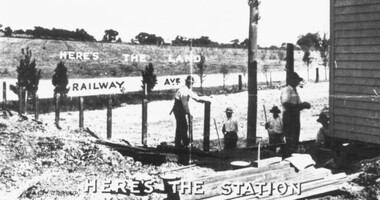 Ringwood and District Historical Society
Photograph, Two promotional photographs depicting Ringwood East Railway Station Estate c.1925
Written on back of one of the photos, "Ringwood East Railway Station entrance and ext ramp opens right on the this Estate" and "Ringwood East Railway Station Estate" -
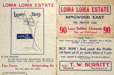 Ringwood and District Historical Society
Flyer, Land Sale Brochure, Loma Loma Estate, Ringwood East, Vic. - circa 1924
Flyer includes extract from "The Sun" 30/10/1924. "Ringwood has been created a Borough with capital value of £680,000. In 1908 there were 173 houses, 8 shops and 720 people. In 1918 the respective figures were 520, 45 and 2,080. For twelve months ended June, 1924, £51,000 worth of Home Sites were sold and £26,000 worth of new buildings were erected. Outward (train) passenger journeys have increased from 94,000 in 1919 to 182,000 in 1923. Train services have been almost doubled and time to Melbourne reduced from 60 to 37 minutes."Bi-fold double-sided land sale advertisement for Loma Loma Estate, Ringwood East, including area map, layout of the estate, and summary of local facilities and services.Subdivision includes Loma Street, Highton Street, Morinda Street, and Station Street (later Railway Avenue) Ringwood East. Agent: T.W. Burkitt, Ringwood, Phone Ringwood 157. -
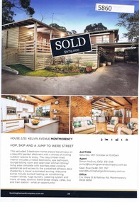 Greensborough Historical Society
Advertising Leaflet, Buckingham and Company Estate Agents, 2/53 Kelvin Avenue Montmorency; and, 3/72 Airlie Road Montmorency, 2018_08
Advertising for 2/53 Kelvin Avenue Montmorency, 2 bedroom house, sold September 2018 for $679,000; previous sale: May 2011 $500,000; and, 3/72 Airlie Road Montmorency, 3 bedroom house, sold 10/01/2019 for $1,140,000; previous sales: February 2014 $775,000 and February 2012 $210,000.Colour page from real estate magazine, printed both sides.kelvin avenue montmorency, airlie road montmorency -
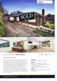 Greensborough Historical Society
Advertising Leaflet, Buckingham and Company Estate Agents, 2A Rattray Road Montmorency; and, 16 Looker Road Montmorency, 2018_08
Advertising for 2A Rattray Road Montmorency, 3 bedroom house, sold October 2018 for $670,000; and, 16 Looker Road Montmorency 3 bedroom house, sold October 2018 for $840,000; previous sales: February 1999 $145,000 and July 1998 $203,000. Colour page from real estate magazine, printed both sides.rattray road montmorency, looker road montmorency -
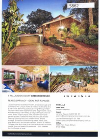 Greensborough Historical Society
Advertising Leaflet, Buckingham and Company Estate Agents, 7 Tallaroon Court Greensborough; and, 15 Yando Street Greensborough, 2018_08
Advertising for 7 Tallaroon Court Greensborough, 4 bedroom house, sold July 2018 for $878,000; previous sales: August 1999 $236,000 and July 1987 $118,000; and, 15 Yando Street Greensborough 3 bedroom house, for sale October 2018 and on market March 2019 for $890,000 plus; previous sales: July 2005 $272,500, March 1981 $43,500 and January 1979 $37,200. Colour page from real estate magazine, printed both sides.tallaroon court greensborough, yando street greensborough -
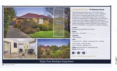
 Greensborough Historical Society
Advertising Leaflet, Buckingham and Company Estate Agents, 3 Karee Court Greensborough; and, 14 Natimuk Street Greensborough, 2018_08
Advertising for 3 Karee Court Greensborough, 3 bedroom house, sold October 2018 for $759,000; previous sale: July 2018 $541,000; and, 14 Natimuk Street Greensborough 3 bedroom house, sold 10/11/2018 for $803,000. Colour page from real estate magazine, printed both sides.karee court greensborough, natimuk street greensborough -
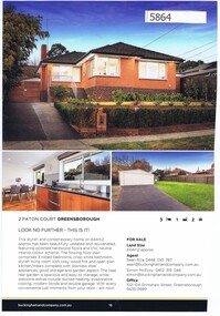 Greensborough Historical Society
Advertising Leaflet, Buckingham and Company Estate Agents, 2 Paton Court Greensborough; and, 8/73 Nell Street Greensborough, 2018_08
Advertising for 2 Paton Court Greensborough, 3 bedroom house, on market March 2019 for $879,000; previous sales: March 2017 $800,000, March 2004 $261,000 and February 1983 $48,000; and, 8/73 Nell Street Greensborough, 2 bedroom house, sold 19/01/2019 for $585,000; previous sales: December 2012 $407,000 and November 2006 $261,000. Colour page from real estate magazine, printed both sides.paton court greensborough, nell street greensborough -
 Greensborough Historical Society
Advertising Leaflet, Buckingham and Company Estate Agents, 1/198 St Helena Road Greensborough; and, 1 & 2/60 St Helena Road Greensborough, 2018_08
Advertising for 1/98 St Helena Road Greensborough, 4 bedroom house, on market March 2019 for $850,000; and, 1 & 2/60 St Helena Road Greensborough, new development, 3 or 4 bedroom homes; previous sales of 60 St Helena Road, sold June 2015 for $520,000, and December 2014 $400,000. Colour page from real estate magazine, printed both sides.st helena road greensborough -
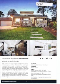
 Greensborough Historical Society
Advertising Leaflet, Buckingham and Company Estate Agents et al, 14 Natimuk Street Greensborough, 2018_08
Advertising for 14 Natimuk Street Greensborough, 3 bedroom house, sold 10/10/2018 for $803,000. Previously the Barnes family home in the early 1950s, this is one of the original homes in Natimuk Street.Colour page from real estate magazine. Link 5863 : 5875natimuk street greensborough -
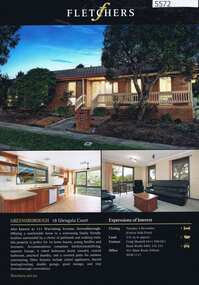 Greensborough Historical Society
Advertising Leaflet, 18 Glengala Court Greensborough, 02/11/2012
18 Glengala Court Greensborough, 4 bedroom brick veneer home, listed for sale 2/12/2012, not sold. Also known as 111 Warralong Avenue, sold 1/02/2012 for $433,000.Real estate leaflet, 1 sheet, printed in colour both sidesglengala court greensborough, warralong avenue greensborough -
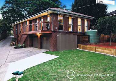 Greensborough Historical Society
Advertising Leaflet, 1/23 Jessop Street Greensborough, 26/09/2014
1/23 Jessop Street Greensborough, 3 bedroom home, sold 06/05/2012 for $435, 000; sold May 2013 for $435,000; sold 26/09/2014 for $465,000 Real estate leaflet, 1 sheet, printed in colour both sidesjessop street greensborough -
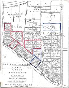 Ringwood and District Historical Society
Map, The East Estate, Township of Ringwood, Victoria - 1927
Photocopied page - partial Parish map of Ringwood labeled The East Estate, showing street names and properties marked with names of individual owners or businesses.Page titled The East Estate by 1927 Part of Township of Ringwood, Parish of Ringwood, County of Mornington, Scale: Four Chains to One Inch. L.F. East blocks are marked by red outline. J. Blood blocks are marked by blue outline. Other names include B.C. Hutchinson & Co., The Victorian Brick & Ornamental Tile Coy., Ltd., The Ringwood Brickmaking Coy., Ltd., R. Davidson, J. Williamson, W.E. Bower, H. Jennings, G.J. Sims, J. Smallman, J. Horne, J. Lindsay, J. Kay, H. Unverhan, B.C. Hutchinson, M.A. Williamson, J.S. Woodworth, J. Price, C. Medew, S.W. Burchett, B.J. Hosking, D.J. Rogers, C. Wheeler, H. Frost, G.G. Miller, L. Winchcombe. Streets include Dublin Road, Illoura Road, Alexandra Road, and Bedford Road. -
 Colac RSL Sub Branch
Work on paper - Baulch Collection, Soldier Settlement Documentation. Lot 21 - Minjah Estate
Historic documentsA4 x3 printed sheets:- - Covering letter from the Soldier Settlement Commission dated 19/10/1955 - Map of Minjah Estate - Map showing the subdivision of Minjah Estate1 x typed letter 2 x copies of mapssoldier settlement allocations -
 Kew Historical Society Inc
Plan - Subdivision Plan, J R Mathers & McMillan, Heart of Richmond Estate : Richmond, 1928
"In 1928 the land on the east side of Johnson Street was subdivided in 60 lots for the ‘Heart of Richmond Estate’. The houses in the subdivision, along the east side of Johnson Street, and in the newly created Hollick, Cole and Kennedy streets were constructed from 1928 to 1937." (Source: City of Yarra Heritage Gaps Review One 2013)Portion of subdivision plan pasted on to cardboard. Area includes Johnson Street, Victoria Street, Kennedy Street, Cole Street, Hollick Street, Bennett StreetTitle Certificate Vol.2381, Folio 476130 Phillips, Fox & Masel, 440 Little Collins Street, Melbourne (Local estate agent: Jas. R. Mathers & McMIllan, 136 Cotham Road, Kew)subdivision plans - richmond (vic.), heart of richmond estate