Showing 235 items matching "farm view"
-
 Whitehorse Historical Society Inc.
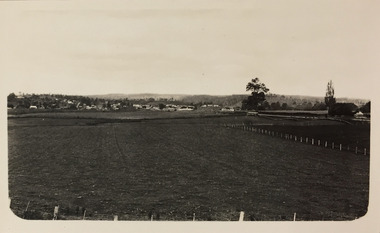
Photograph, Eckermann's Poultry Farm, c1960
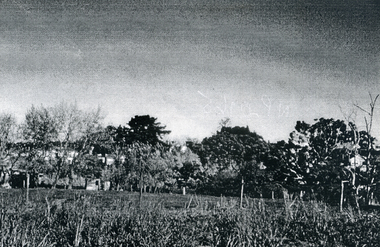
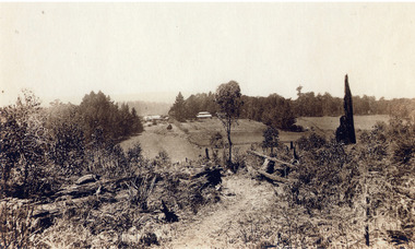
... View from Eckermann's Poultry Farm. Looking towards... boyles white bruer's View from Eckermann's Poultry Farm. Looking ...Photographs relate to the Poultry Farms that existed in Nunawading and Forest Hill in the1950s and 1960s. Photos taken in 1961-62. Poultry farmers included Messrs Boyce, Gallos, Foote,Grimsley, Greenwood and Dudley|Slides scanned as a 'tiff' at 300dpi to CD Rom and cleaned and adjusted by Ted Arrowsmith.View from Eckermann's Poultry Farm. Looking towards the White's, Boyle's and Greenwood's properties on Canterbury.eckermann's, eckermann frank, poultry farms, nunawading, greenwood, forest hill, canterbury road, mount pleasant road nunawading, boyles, white, bruer's -
 Whitehorse Historical Society Inc.
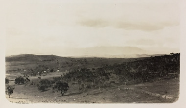
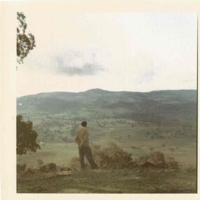
Photograph, Eckermann's Poultry Farm, c1960
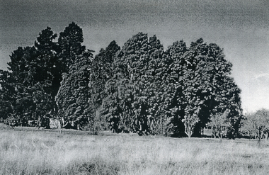
... View of Eckermann's Poultry Farm. The cypress trees... boyles white bruer's View of Eckermann's Poultry Farm ...Photographs relate to the Poultry Farms that existed in Nunawading and Forest Hill in the1950s and 1960s. Photos taken in 1961-62. Poultry farmers included Messrs Boyce, Gallos, Foote,Grimsley, Greenwood and Dudley|Slides scanned as a 'tiff' at 300dpi to CD Rom and cleaned and adjusted by Ted Arrowsmith.View of Eckermann's Poultry Farm. The cypress trees at the back of the farm.eckermann's, eckermann frank, poultry farms, nunawading, greenwood, forest hill, canterbury road, mount pleasant road nunawading, boyles, white, bruer's -
 Whitehorse Historical Society Inc.
Photograph, View from Mr. Boyle's orchard, c1960
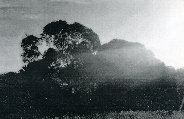
Photographs relate to the Poultry Farms that existed in Nunawading and Forest Hill in the1950s and 1960s. Photos taken in 1961-62. Poultry farmers included Messrs Boyce, Gallos, Foote,Grimsley, Greenwood and Dudley|Slides scanned as a 'tiff' at 300dpi to CD Rom and cleaned and adjusted by Ted Arrowsmith.Early morning sunrays on Boyle's gum trees - 6.30 am.eckermann's, eckermann frank, poultry farms, nunawading, greenwood, forest hill, canterbury road, mount pleasant road nunawading, boyles, white, bruer's -
 Ballarat Heritage Services
Photograph - Photograph - Colour, Clare Gervasoni, Lavendula, Shepherd's Flat
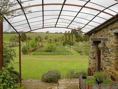
The Lavendula property was formerly the home and farm of the Tinetti family of Biasca, Ticino, SwitzerlandColour photograph of a view at Lavendula, Shepherd's Flat.lavendula, shepherd's flat, tinetti, swiss/italian, farm, agriculture -
 Ballarat Heritage Services
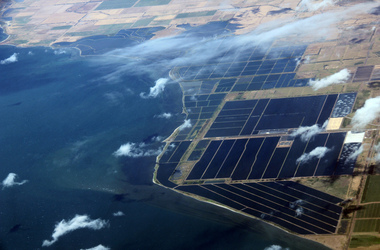
Digital Photograph, L.J. Gervasoni, werribee farm from the air, 2016
Digital Image showing an aerial view of the Melbourne Central Business District and Royal Park.aerial, melbourne, werribee farm, sewerage -
 Ballarat Heritage Services
Photograph - Photograph - Colour, Clare Gervasoni, View from the Window of the Ballarat - Melbourne Train, 2016, 2016
Farmland from the train windowballarat - melbourne train, farms, landscape, railway, bacchus marsh, ballan -
 City of Ballarat Libraries
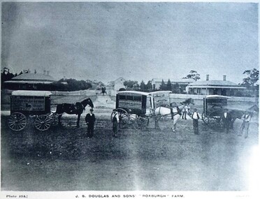
Postcard - Card Box Photographs, J.S. Douglas and Sons 'Roxburgh' Farm
View from the Yard. Champion Jersey Bull 'Hero'. Ayrshire Stud. Milking Time. Plates 154, 155, 159, 160 & 161 Chuck Photo Series.j.s. douglas, roxburgh farm, farming, building, persons, costume, livestock -
 Ballarat and District Irish Association
Photograph - Colour, Clare Gervasoni, Crossley near 'Hillside" McCartney's Lane, 2014, 04/04/2014
Before 1941 "Hillside", McCartney's Road was associated with the Carroll Family. Patrick Edmund Carroll, his wife Mary Matilda Fitzgerald, and children Kathleen, Ronald and Rosemary were the last members of the family to live at and work "Hillside". Stanislaus Kelly and his wife Margaret (nee Gorman) bought the farm from the Carroll family. The couple raised six children on the land: May, Mary, Leo, Ray (Lofty), Daniel (Tich) and Bernadette. The family grew spuds and onions on the hill and milked cows, with the little dairy located on the eastern side of the house. (information from Mary Kelly)Colour digital photographs of Crossley, Victoria, near McCartney's Lane. The house depicted is "Hillside" in McCartney's Lane. The views towards an extinct volcano is Tower Hill.crossley, hillside, carroll, tower hill, mccartney's lane -
 Mt Dandenong & District Historical Society Inc.
Photograph, View Up Valley At Kalorama
John Lundy-Clarke grew up in the Kalorama/Mt Dandenong area and later in life (1972-74) began to write a comprehensive history of the area working from an original settlement map in an effort to cover all areas. The building in the centre of the photograph is 'Kia-Ora' guest house. Situated on Barber’s Road, ‘Kia-Ora’ was built in 1912 by George Barber. It was later leased by a Mrs Pemberthy. “Kia-Ora’ was one of four places connected when the telephone was brought into the district in 1912. The other places were ‘Mountjoy’, ‘Cherry Farm’ and ‘Callum House’. ‘Kia-Ora’ was burnt down in 1924. Black and White copy of section of a Rose Series postcard. Shows view up the valley at Kalorama with a decorative building centre middle of photograph. Handwritten description by John Lundy-Clarke on reverse.View up valley at Kalorama from near junction of Barbers and Doughty’s Rds. “Kia Ora” guest house in centre. Paynter’s “Iona” top left with “Kalorama” to its right. About 1912. Rose Series copied by JLC 1973.kalorama, kalorama valley, john lundy-clarke, barbers road, george barber, kia-ora, guest house, iona -
 Mt Dandenong & District Historical Society Inc.
Photograph, View From Ernest Road To Site Of "Kia-Ora"
John Lundy-Clarke grew up in the Kalorama/Mt Dandenong area and later in life (1972-74) began to write a comprehensive history of the area working from an original settlement map in an effort to cover all areas. The photograph taken c1973 from Ernest Road looks over the site of the Kia-Ora guesthouse which is marked by the oalm tree that can be seen at the front of the flat roof close to the gum tree trunk. Situated on Barber’s Road, ‘Kia-Ora’ was built in 1912 by George Barber. It was later leased by a Mrs Pemberthy. “Kia-Ora’ was one of four places connected when the telephone was brought into the district in 1912. The other places were ‘Mountjoy’, ‘Cherry Farm’ and ‘Callum House’. ‘Kia-Ora’ was burnt down in 1924.Black and white photograph showing a house with water tank in right foreground and another flat roof centre foreground. There is a handwritten description by John Lundy-Clarke on the reverse.View 1973 from corner of Ernest Rd and Outlook Drive Lot 24 Village Settlement looking over the site of “Kia Ora” to the pioneers clearings. The palm tree seen above the flat roof (Rex) on left, is on the exact site of “Kia Ora”. Photo JLCernest road, john lundy-clarke, kia=ors, guest house, guesthouse -
 Mt Dandenong & District Historical Society Inc.
Photograph, Walker's LOT 2
Harry Walker's property would have been run by his son William in 1922. When the CRB Road cut through the property William planted plum trees on the opposite side. These are visible in this photo. An extensive raspberry crop is in the foreground. The building over the road on the left hand side is the corn and produce store built by Edward John Price (son of Edward Joseph Price) to capitalise on the CRB Road cutting through the Price farm. John Lundy-Clarke grew up in the Kalorama/Mt Dandenong area and later in life (1972-74) began to write a comprehensive history of the area working from an original settlement map in an effort to cover all areas.Small black and white postcard showing a crop in foreground with a house to the right. A road passes through the centre with a house on the left on the opposite side of the road. A view to the ranges in the distance. A handwritten description on reverse by John Lundy-Clarke.View at Kalorama. View over LOT 2 (Walkers) 1922.harry walker, william walker, crb road, raspberry, edward john price, edward joseph price, produce store, store -
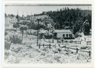
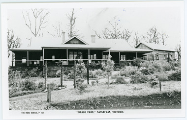 Mt Dandenong & District Historical Society Inc.
Photograph, Braco Park, c1913
Braco Park Guest House was owned by the aunts of Sir Keith Murdoch, Eliza and Grace. It became a Red Cross convalescent Home for nurses in 1918.It was sold to Mrs. Techow and renamed "Clovelly" in 1920. It had been the Murdoch sisters' guest house, Braco Park, that originally introduced Prime Minister Billy Hughes to the hills. Walter Murdoch's nephew Keith Murdoch, a young parliamentary reporter for the Age, took Hughes and several other politicians up there before the war. Keith's father had been a friend of the previous PM, Andrew Fisher. Keith Murdoch was sent to London as a reporter in 1915, and developed an influential relationship with Hughes who bought a small farm in Sassafras, and ran some of the business of government there during the war and after. Acquired by The Education Department about 1985, the Sherbrooke Community School was built, with the Clovelly house being stripped back to its frame and renovated to form the main building of the school. An existing cottage on the site is also used. B & W postcard showing the front view of Braco Park with another small building to the RHS. Newly planted garden in the front.The Rose Series P. 106. "BRACO PARK" SASSAFRAS, VICTORIA.braco park, clovelly, guest house, murdoch, sherbrooke community school -
 Mt Dandenong & District Historical Society Inc.
Photograph, Mountain Grange and Great Barn Kalorama
... ". View taken from "Cherry Farm" hill looking across farm (now... of a postcard titled "Looking Towards Healesville". View taken from ...Copy of a postcard titled "Looking Towards Healesville". View taken from "Cherry Farm" hill looking across farm (now the Kalorama Memorial Reserve), which was the property of Thomas and Eliza Hand. Location recognised because of likeness to a painting.eliza hand, mountain grange, thomas hand -
 Ballarat Tramway Museum
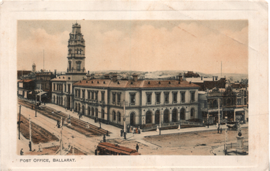
Postcard, J Ewins, "Post Office, Ballarat", 1911
View of the intersection of Sturt St and Lydiard St Nth with the Ballarat Post Office being the primary feature. Has an ESCo tram turning from Sturt St into Lydiard St. Shows the trackwork at this location and has several horse-drawn vehicles in the photograph. Would appear that Lydiard St north has either been watered or is being repaired. On the rear is a message to friends of a lady keeping house on a farm (Coolaban) near Lubeck Vic. It is dated 29/10/1911.Demonstrates postcard printing c1910 and has a strong association with the sender.Postcard - coloured, divided back, published by J. Ewins of Ballarat and printed in England.See image 2 for the letter sent in 1911.tramways, trams, esco, post office, lydiard st nth, sturt st -
 Ballarat Tramway Museum
Slide - 35mm slide/s - set of 6, John Theodore, 1972 - 1973
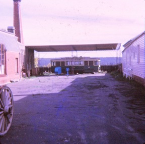
... - late view with other farm machinery placed around it. .3... - view from the roadway .2 - late view with other farm machinery ...Yields information about tram 11 following its disposal and how it was placed at the Daylesford Museum.Set of 1 Kodachrome cardboard slides and 5 AGFA blue and white plastic mount 27mm sq slides of former Ballarat tram 11 at the Daylesford Historical Society yard. .1 - view from the roadway .2 - late view with other farm machinery placed around it. .3 - interior view .4 - interior view .5 - view showing how the tram was placed. .6 - interior viewed.Various notations by John as to the slide number and the trams in pencil and ink.tramways, trams, closure, tramcars, disposal, daylesford, tram 11 -
 Bendigo Historical Society Inc.
Audio - The 1930s Depression Tapes - Doris Hannah Moyle, 2005
In 2005 Michele Matthews interviewed current and former residents of Bendigo for her thesis on the 1930s Depression as part of her PhD Research, with the University of Melbourne Faculty of Arts, History Department. Michele interviewed fifteen members of prominent Bendigonian families. The thesis was titled: "How Depressing?: The impact of the Great Depression on Bendigo and District 1925-1935". The Michele Matthews Collection contains fourteen audio cassette tape recordings and one written transcript. The tapes are each approximately 1 hour and 45 minutes duration. The questions presented to the interviewees explore everyday experiences they would have lived through at the time of the Depression. The questions covered sixteen relevant subjects: • Introduction and housing • Social activities, swimming, cinemas, school and games played with friends • Organizations such as the RSL, Relief Committees etc. and any effect they had on family life • The life of the single woman • Unemployment and Employment • Government Assistance • Charities Aid • Self-help • People Power, e.g. boycotts or protests • Politics • Trouble or crime • Family Health, Medical and Diet • Education • General memories of, and hardships encountered, during the DepressionAudio tape interview with Doris Hannah Moyle, born in 1922. Daughter of Henry Phillip (a farm labourer, sleeper cutter and horse breaker), and Edith May Harvey. She attended school at Quambatook State School, 1926-1929, Cohuna State School, 1929-1931, Camp Hill State School, 1931-1934, Bendigo High School, 1935-1936 and attained her merit certtificate. Doris married Louis Mankin Moyle in 1948. The tape has been converted to a sound file. The 90 minute interview can be listened to, and the notes viewed, at the Bendigo Historical Society. By appointment only.history, bendigo, michele matthews collection, the 1930s depression tapes, doris hannah moyle -
Moorabbin Air Museum
Machine - Southern Cross SC-1 VH-SCA, 1957
Historical Details: . Description: The Toowoomba Foundry was established in 1870 and for over 100 years manufactured farm equipment in Queensland under the Southern Cross brand. In 1957 the company began construction of a prototype aircraft with the view to local manufacture. The co. Level of Importance: State -
 Kew Historical Society Inc
Photograph - River Yarra in Flood from Kilby Road
... diminished. Kilby Road Floods -- Kew (Vic.) Kilby farm VIEW ACROSS ...Flooding of the Yarra Valley, including that section of the Yarra bordering Kew and Kew East in the north and west of the municipality, was a regular occurrence. Extreme flood events of the Yarra River are recorded to have occurred in 1891, 1901, 1916, 1923 and 1934. The Municipality of Kew's response to these floods was to enact planning decisions restricting residential development in flood prone areas following the floods of 1916, 1921 and 1934. While floods continued after the development of the Upper Yarra Reservoir (construction 1948-57), the regularity and extent of these inundations diminished.Print copy of an original photo of the River Yarra in Flood, taken from Kilby Road.VIEW ACROSS YARRA IN FLOOD / FROM KILBY RD KEWkilby road, floods -- kew (vic.), kilby farm -
 Kew Historical Society Inc
Photograph - Panoramic landscape, c.1926
Henry Beater Christian (1886-1962) , was a descendant of one of the earliest settler families in Kew. Employed at the Kew Asylum as a 'public servant', he was a skilled amateur photographer, photographing numerous scenes in Kew and on his travels around Victoria. The majority of his photographs date from 1916 to 1929. His finest photographs are housed in two photograph albums. Digital copy of a photograph from page 30 of the 47-page photograph album containing 261 gelatinous silver images, loaned by Diane Washfold with permission given to digitise and hold a copy in our collection. John Chapman has written in 'Bushwalking Clubs - A Brief History', about the establishment in Victoria of the first bushwalking club in 1888, and the popularisation of bushwalking during the interwar period. Henry Christian's 'walks' appear to have been undertaken solely or with a companion/s. This black and white panoramic photo is untitled, but follows a page of photos taken on a walking trip between Cockatoo and Gembrook in Victoria. The view selected by the photographer is of a farmed and settled valley with roads and scattered buildings.[Untitled]henry beater christian (1886-1962), landscape photography, christian-washfold collection, photograph albums, bushwalking -
 Kew Historical Society Inc
Photograph - Farmland, near Bruthen or Swan Reach, 1926
Henry Beater Christian (1886-1962) , was a descendant of one of the earliest settler families in Kew. Employed at the Kew Asylum as a 'public servant', he was a skilled amateur photographer, photographing numerous scenes in Kew and on his travels around Victoria. The majority of his photographs date from 1916 to 1929. His finest photographs are housed in two photograph albums. Digital copy of a photograph from page 31 of the 47-page photograph album containing 261 gelatinous silver images, loaned by Diane Washfold with permission given to digitise and hold a copy in our collection. John Chapman has written in 'Bushwalking Clubs - A Brief History', about the establishment in Victoria of the first bushwalking club in 1888, and the popularisation of bushwalking during the interwar period. Henry Christian's 'walks' appear to have been undertaken solely or with a companion/s. This black and white photo is part of a group of six photos taken on an 18 kilometre walking trip between Bruthen and Swan Reach in East Gippsland in 1926. The route of the walk followed the Tambo River. The photographer focusses the camera view on the township in the distance with farms in the foreground."BRUTHEN TO SWAN REACH 1926"henry beater christian (1886-1962), landscape photography, christian-washfold collection, photograph albums, bushwalking, bruthen, swan reach, tambo river, east gippsland -
 Kew Historical Society Inc
Photograph - Farms near Omeo, c.1926
Henry Beater Christian (1886-1962) , was a descendant of one of the earliest settler families in Kew. Employed at the Kew Asylum as a 'public servant', he was a skilled amateur photographer, photographing numerous scenes in Kew and on his travels around Victoria. The majority of his photographs date from 1916 to 1929. His finest photographs are housed in two photograph albums. Digital copy of a photograph from page 33 of the 47-page photograph album containing 261 gelatinous silver images, loaned by Diane Washfold with permission given to digitise and hold a copy in our collection. John Chapman has written in 'Bushwalking Clubs - A Brief History', about the establishment in Victoria of the first bushwalking club in 1888, and the popularisation of bushwalking during the interwar period. Henry Christian's 'walks' appear to have been undertaken solely or with a companion/s. This black and white photo is part of a group of photos taken in the Victorian High Country. The page is labelled 'Omeo' and includes photos of landscapes, individuals, and towns. This small black and white photo is a panoramic view farmland near Omeo in Victoria."OMEO"henry beater christian (1886-1962), landscape photography, christian-washfold collection, photograph albums, bushwalking, northeast victoria, victorian high country, omeo -
 Kew Historical Society Inc
Photograph - Yarra Valley Floods: Kew East, 1916
Flooding of the Yarra Valley, including that section of the Yarra bordering Kew and Kew East in the north and west of the municipality, was a regular occurrence. Extreme flood events of the Yarra River are recorded to have occurred in 1891, 1901, 1916, 1923 and 1934. The Municipality of Kew's response to these floods was to enact planning decisions restricting residential development in flood prone areas following the floods of 1916, 1921 and 1934. While floods continued after the development of the Upper Yarra Reservoir (construction 1948-57), the regularity and extent of these inundations diminished. During the nineteenth century, the land abutting the south side of the Yarra in Kew was devoted to dairy farming. In the twentieth century, before and after the construction of the Eastern Freeway, much of this low-lying area was used as golf courses and public parks.One of a collection of photographs of flooding in the Kew section of the Yarra Valley which are in important research resource for the location and extent of flooding in the first half of the twentieth century. Flooding of the Yarra Valley at East Kew in 1916. The view is taken from a street (maybe Birdwood Avenue) intersecting with Kilby Road looking northeast across the flood waters to Ivanhoe and Heidelberg. The extensive flooded area shown in the photograph would have included remnant dairy farms and the Kew Golf Club. Verso: "Floods / Yarra River / East Kew / Kilby Road / 1917? / 87"yarra river, yarra valley, floods -- kew, kilby road -- kew (vic.), kew golf club -
 Friends of Westgarthtown
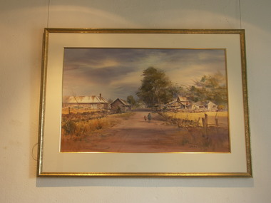
Painting, John Borrack, Ziebells, German Lane, South View
Painted from Gardenia Road. The extensive farm complex on the right. (Western side of Gardenia Road). was demolished in 1972 for housing development. Buildings shown are cowshed, hay barn, engine shed and stables. Painted in the late afternoon, the lengthening shadows and lowering sky, could presage the ominous fate awaiting the farm with development. The Ziebell Farm was known as “The Pines†and sadly none of the many that proliferated there remain. Today they would be equivalent to those at the cemetery, having been planted at the same time. Provenance: John Borrack CollectionWatercolour depicting Ziebell Farmhouse from the north, Thomastown and Mernda. In gold frame with cream border.Artist signature: John Borrack; 70's Ziebells German Lane South Viewillustrations, watercolours, john borrack, ziebell, watercolour, painting -
 Expression Australia
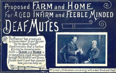
Booklet, Proposed Farm and Home for Aged Infirm and Feeble Minded Deaf Mutes
The Premier of Victoria, the Hon, Thomas Bent, has promised a grant of 2,000 pounds towards providing a Training farm for Feeble-minded, and home for Aged and infirm Deaf Mutes, conditionally that a further sum of 2,000 pounds be raised for the same purpose at once. The Committee of the Adult Deaf and Dumb Mission of Victoria having accepted this generous offer of the Government, produced this booklet with the desire to bring the scheme under the notice of the public with a view of appealing to it for the sum named.This booklet is significant as it marks the beginning of a major project, Lake Farm, Blackburn that sought to provide employment and residential facilities for aged and infirm Deaf adults in Victoria in the early years of the 20th Century.Size 13.5cmHx21.5cmW; 16 pagesdeaf, blackburn, thomas bent,ernest j. d. abraham, south australian farm and home for infirm deaf mutes, -
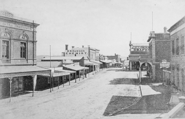 Stawell Historical Society Inc
Photograph, Upper Main Street Stawell looking West with the Mechanics institute built in 1875 1878
Upper Main Street looking West from Mechanics Institute built in 1875. Mechanics Institute, Joseph Dawe Stawell Meat Market, D.B. O'Callaghan, Boot & Shoe Warehouse, Stawell Potato Depot, Ben S. Dawson Chemist, R.H. Wadsworth Jewler Watchmaker, English Scottish & Australian Bank, Bone Saddler, Hunter Bull & Mouth Hotel. On North side of street is J. Allingham Draper, Chadwick & Co Draper, D. Telford Farm Produce, Bank of Victoria. Photo taken 1878The "Top End" of Main Street. looking west. The Mechanics Insitute on the Left dates the photo about 1880. Some of the larger buildings have been restored.Victorian Views. C. Herbert, Photo. Stawell 1878stawell business streetscape -
 Surrey Hills Historical Society Collection
Photograph, Subdivision sale of Black's Mont Albert farm in 1924, 1924
Photo was taken in 1924 when the land was subdivided. Black's dairy farm occupied the area just east of Hamilton Street to near Elgar Road. It was subdivided into 88 house allotments along Churchill Street, Bruce Street, Black Street, Proudfoot Street and View Street. The solicitors were Proudfoot & Horton, 360 Collins Street; estate agents were Duncan & Weller, 29 Queen Street. The real estate subdivision notice on the SLV website states that Neil Black had been the owner for 50 years. To date no trace of a Neil Black has been found. Box Hill rate books simply give BLACK as the owner in 1877 (no first name); the entry for 1878-1884 states Robert Black. The 1909 electoral roll has entries for Mont Albert Road for Robert Black (farmer), Thomas Black (carter) & Elizabeth Black (HD). The 1912 electoral roll has entries for Mont Albert Road for Robert Black (farmer), Thomas Black (labourer), John Arthur Black (carter) & Elizabeth Black (HD). Robert Black died in 1920 (b. 1836) and is buried in Box Hill Cemetery (CE-*-0057). His parents were John and Margaret Black. He married Lizzie Foley in 1878. She was the daughter of Margaret & John Foley, born in 1859. She died in 1902 aged 43 years and is buried in the same grave, although the cemetery records record her age as 0 years (presumably as no age or date of birth were given at the time of burial). Children: 1. James Hughbert (1880-1954) 2. John Arthur (1881-1959) 3. Alice (1882-1883) - died aged 6 months 4. Laura Elizabeth (1883-1951) 5. Thomas (1885-1965) 6. Isabella (1887-1963) 7. Eleanor (1889-1963) 8. Ada Maud (1890-1968) 9. Robert (1892-1930). BDM Victoria states places of birth as Box Hill, Surrey Hills or Mont Albert. Many of the family are buried in Box Hill Cemetery. None of the girls appear to have married. Communication from a descendant of John Arthur Black gives the following: "John Arthur Black, son of Robert & Lizzie Foley, married Gladys Anne Layton had 4 children, Robert, Elenore, Marion (Follett) & Annie; they had farm on Stud Road, Dandenong where they milked 30 cows that he retired to after being a earth-moving contractor with draft horses and dug irrigation ditches around Shepparton." This is important as documentation of the area's transformation from farming land to residential land use.Black and white photo of a large 3-poled tent in an area of flat land with eucalypts in the background. There is a large crowd of people, mainly men but also women and children. There are also 3 cars to the RHS.black's dairy farm, dairying, farms, churchill street, black street, proudfoot street, bruce street, view street, neil black, proudfoot & horton, duncan & weller, robert black, lizzie black, lizzie foley, james hubert black, john arthur black, alice black, laura elizabeth black, thomas black, isabella black, eleanor black, ada maud black, robert black jnr, box hill cemetery, land sales -
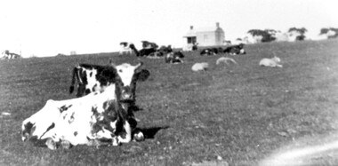 Surrey Hills Historical Society Collection
Photograph, Norman Carter, Part of Black's dairy farm in Mont Albert in the 1920s, 1920s
Photo is likely to have been taken pre-1924 when the land was subdivided. Donor information is that this was taken from a home in Churchill Street, Mont Albert; it would be looking south towards Mont Albert Road. Black's dairy farm occupied the area just east of Hamilton Street to near Elgar Road. It was subdivided into 88 house allotments along Churchill Street, Bruce Street, Black Street, Proudfoot Street and View Street. The solicitors were Proudfoot & Horton, 360 Collins Street; estate agents were Duncan & Weller, 29 Queen Street. The real estate subdivision notice on the SLV website states that Neil Black had been the owner for 50 years. To date no trace of a Neil Black has been found. Box Hill rate books simply give BLACK as the owner in 1877 (no first name); the entry for 1878-1884 states Robert Black. The 1909 electoral roll has entries for Mont Albert Road for Robert Black (farmer), Thomas Black (carter) & Elizabeth Black (HD). The 1912 electoral roll has entries for Mont Albert Road for Robert Black (farmer), Thomas Black (labourer), John Arthur Black (carter) & Elizabeth Black (HD). Robert Black died in 1920 (b. 1836) and is buried in Box Hill Cemetery (CE-*-0057). His parents were John and Margaret Black. He married Lizzie Foley in 1878. She was the daughter of Margaret & John Foley, born in 1859. She died in 1902 aged 43 years and is probably buried in the same grave, although the cemetery records record her age as 0 years. Children: 1. James Hughbert (1880-1954) 2. John Arthur (1881-1959) 3. Alice (1882-1883) - died aged 6 months 4. Laura Elizabeth (1883-1951) 5. Thomas (1885-1965) 6. Isabella (1887-1963) 7. Eleanor (1889-1963) 8. Ada Maud (1890-1968) 9. Robert (1892-1930). BDM Victoria states places of birth as Box Hill, Surrey Hills or Mont Albert. Many of the family are buried in Box Hill Cemetery. None of the girls appear to have married. Communication from a descendant of John Arthur Black gives the following: "John Arthur Black, son of Robert & Lizzie Foley, married Gladys Anne Layton had 4 children, Robert, Elenore, Marion (Follett) & Annie; they had farm on Stud Road, Dandenong where they milked 30 cows that he retired to after being a earth-moving contractor with draft horses and dug irrigation ditches around Shepparton." This is important as documentation of the area's early farming land use.Black and white photo of a paddock with cows and sheep grazing. On the horizon is a simple cottage with a small veranda and 2 chimneys and scattered trees.black's dairy farm, dairying, farms, churchill street, black street, proudfoot street, bruce street, view street, neil black, proudfoot & horton, duncan & weller, robert black, lizzie black, lizzie foley, james hubert black, john arthur black, alice black, laura elizabeth black, thomas black, isabella black, eleanor black, ada maud black, robert black jnr, box hill cemetery -
 Port Fairy Historical Society Museum and Archives
Photograph
... Street Port Fairy great-ocean-road Woodbine - rearside view ...Woodbine - rearside viewPhotographwoodbine, lagoon farm -
 Port Fairy Historical Society Museum and Archives
Photograph
... Street Port Fairy great-ocean-road Woodbine - side view woodbine ...Woodbine - side viewPhotographwoodbine, lagoon farm -
 Falls Creek Historical Society
Photograph - At Toonallook
... A collection of colour images of mountain views and one... A collection of colour images of mountain views and one of farm work ...These photos are part of the Fred Griffith Collection. Frederick Charles “Fred” Griffith was born in Albury, NSW on 2 March 1910. Educated in Albury and Geelong Grammar. Beginning in 1927 he spent many years working first as a jackeroo and on a range of prominent pastoral and merino stud properties in NSW and Queensland. In 1935 he repurchased his former family property “Toonallook, Bowna, NSW and developed it to be the largest Romney Marsh stud in the world, exporting rams to Argentina. He introduced many innovative practices on his property including rabbit control measures and aerial crop dusting. He was an active member of the Albury Show Society and in 1949 established the Albury Sheep Show. Fred was also the Albury representative on the Graziers’ Association Council for over 30 years. He became a life member of both the Albury and Commercial Clubs. Fred’s greatest hobby was snow skiing. His first visit to the snow was to Kosciusko in 1919. The Albury Ski Club was formed in 1935 and Fred was an inaugural member. In 1949 they were granted a site at Falls Creek to build their own lodge. Fred guaranteed the Club for finance from the Bank of NSW. The first portion of the prefabricated building was constructed in Albury. It was transported to Falls Creek on the back of Fred’s truck and erected in one day. This was the bathroom section and the rest was completed in 1950. The original lodge was burned down in 1952 and a new one built the following year. In 1955, Fred also built the Bowna Lodge for his family in partnership with David Fairbairn. He became head of the North Eastern District Skiing Association (N.E.D.S.A.) and successfully applied to run the Australian Ski Championships. Fred also inaugurated children’s races at Falls Creek and ran them for about 20 years. He also formed the company “Falls Creek Ski Tows”. In 1956 Fred along with a group of key people selected the site for Thredbo Village. Fred and his brother sold Toonallook in sections between 1951 and 1974. He moved to Albury and set up as a landscape gardener and fencing contractor. After a serious work accident, Fred retired in 1985 and moved to Rosebud, Victoria where he died on 19 August 1992.These images are part of an important collection donated by Fred Griffith which document Falls Creek in the 1950s & 1960sA collection of colour images of mountain views and one of farm work.falls creek, falls creek lodges, norma tullo