Showing 3044 items
matching first building
-
 Orbost & District Historical Society
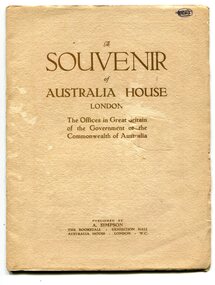
souvenir book, Souvenir of Australia House, 1920's
... George V laid the building’s first foundation stone in 1913... mission in London. King George V laid the building’s first ...Australia House is the oldest Australian diplomatic mission and it is the longest continuously occupied foreign mission in London. King George V laid the building’s first foundation stone in 1913 but it was not until August 1918 that he officially opened the completed building. The stringencies of World War I – principally shipping difficulties and labour shortages – had delayed construction considerably. Federation of the six Australian states formally took place on 1 January 1901 but it was not until 1906 that the Federal Government sent an Official Secretary to London to represent Australia. In the intervening years Australia was represented by State Agents-General, the first of whom was the Agent-General of Victoria. The building is significant for its unique design, Beaux Arts style and the materials used in its construction. In the early 1900s black marble was being mined in the Bruthen district. Some was used for the Shrine of Remembrance in Melbourne and Australia House in London. 900 tonnes were shipped to London to be included in the construction of Australia House. This item is a useful research tool.A paper covered booklet which is a pictorial souvenir Of Australia House in London. Pictures show Buchan marble features of the building.buchan-marble australia-house -
 Eltham District Historical Society Inc
Photograph, Watson's Eltham Hotel, Maria Street, Eltham, c.1900
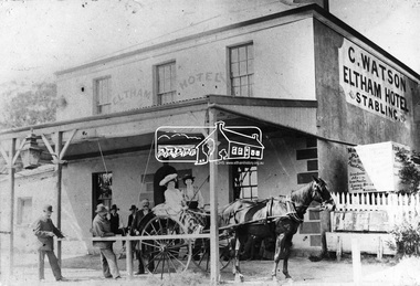
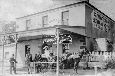
... , and received the first licence. The building was constructed of hard..., and received the first licence. The building was constructed of hard ...Christoher Watson's Eltham Hotel, cnr Maria Street (Main Road) and Pitt Street, Eltham. Christopher Watson in centre (bareheaded). Reproduced on p60 of 'Pioneers & Painters' The hotel was constructed in the 1850s immediately following the discovery of gold in Victoria. The original founder, a Mr Warren. engaged a builder named Wallace, to erect the hotel, and being unable to finance it, the story goes, handed it over to Mr Wallace, who finished the job, and received the first licence. The building was constructed of hard basaltic blue stone, quarried in the Eltham district, and partly of bricks made at Eltham. At that time the town owned not only an hotel, but a flour mill, a brewery, a brickworks, and other important industries. The hotel was carried on for the benefit of the first owners for over 30 years and was then purchased by Mr Chris Watson. The hotel was in the early days a well-known resting place for the gold diggers during the gold rush at Woods' Point. A new hotel was erected on the same site by Mr H. Watson in 1925.This photo forms part of a collection of photographs gathered by the Shire of Eltham for their centenary project book,"Pioneers and Painters: 100 years of the Shire of Eltham" by Alan Marshall (1971). The collection of over 500 images is held in partnership between Eltham District Historical Society and Yarra Plenty Regional Library (Eltham Library) and is now formally known as the 'The Shire of Eltham Pioneers Photograph Collection.' It is significant in being the first community sourced collection representing the places and people of the Shire's first one hundred years.Digital imagechristopher watson, eltham, hotel, main road, maria street, pioneers and painters, pitt street, shire of eltham pioneers photograph collection, watson's hotel -
 Eltham District Historical Society Inc
Photograph, Watson's Eltham Hotel, Maria Street, Eltham, c.1900
... , and received the first licence. The building was constructed of hard..., and received the first licence. The building was constructed of hard ...Christoher Watson's Eltham Hotel, cnr Maria Street (Main Road) and Pitt Street, Eltham. Christopher Watson in centre (bareheaded). Reproduced on p60 of 'Pioneers & Painters' The hotel was constructed in the 1850s immediately following the discovery of gold in Victoria. The original founder, a Mr Warren. engaged a builder named Wallace, to erect the hotel, and being unable to finance it, the story goes, handed it over to Mr Wallace, who finished the job, and received the first licence. The building was constructed of hard basaltic blue stone, quarried in the Eltham district, and partly of bricks made at Eltham. At that time the town owned not only an hotel, but a flour mill, a brewery, a brickworks, and other important industries. The hotel was carried on for the benefit of the first owners for over 30 years and was then purchased by Mr Chris Watson. The hotel was in the early days a well-known resting place for the gold diggers during the gold rush at Woods' Point. A new hotel was erected on the same site by Mr H. Watson in 1925.Early photo of Eltham Hotel which has been on site in various forms since mid 1800sSepia photograph mounted on cardInscribed on back: "Property of Mr Albert Watson, 53 Yarra St, Heidelberg. Christopher Watson (bare headed) Given to Marion Huggett December 1977 c.1900 son of Watson Snr behind cart"christopher watson, eltham, eltham hotel, main road, maria street, pioneers and painters, pitt street, shire of eltham pioneers photograph collection, watson's hotel -
 City of Ballarat Libraries
Australian Historical Record Society papers, Reminiscences - Strange But True Stories About Gold. J.M. Meek
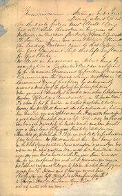
... Mr. James McCain Meek boasted of building the first house... lithography Mr. James McCain Meek boasted of building the first house ...The Australian Historical Records Society existed in Ballarat between 1896 and 1906. They were one of Australia's first historical societies, and were in the position to still be able to talk to early pioneers. They invited such pioneers to either submit letters or memoirs, or to address the Society's meetings, where their reminiscences were taken down in shorthand and later typed up. The Society also attempted to preserve memorabilia from Ballarat's early days, but on the disbanding of the group in 1906, materials were stored at the Ballarat Town Hall and were later lost. It is not known how the papers made their way to the then Ballarat Municipal Library, but they have been part of the Library's collection for many years.Mr. James McCain Meek boasted of building the first house in Ballarat, on the corner of Dana and Lydiard Streets, which was also a lemonade store and some say a sly grog shop. Meek arrived in Australia in 1847. He was in Ballarat 1851-1853, and in later life he returned to Ballarat to live at the Benevolent Asylum. When he became very ill in 1898 his daughter Marianne Dallimore took him to live with her, and he died at her property near Warrnambool in 1899. He wrote these reminiscences for the AHRS, of which he was a member. He was an excellent penman and illustrator and he produced several extraordinary complicated works. Meek was the subject of a PhD project undertaken at Federation University Australia by Joan Luxembourg, resulting in the 2015 publication The Inimitable Mr Meek. ballarat, illustration, goldrush, lithography -
 Eltham District Historical Society Inc
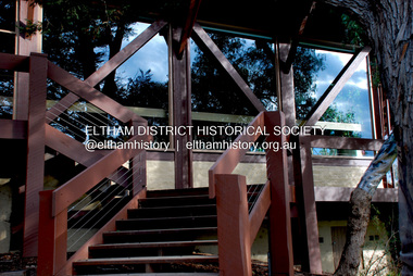
Photograph - Digital Photograph, Jim Connor, Eltham Community and Reception Centre, 801 Main Road, Eltham, 9 July 2008
... first public mud-brick building. Commissioned in 1977 by Eltham... first public mud-brick building. Commissioned in 1977 by Eltham ...The Eltham Community and Reception Centre was Australia's first public mud-brick building. Commissioned in 1977 by Eltham Shire Council, led by Shire president (and architect) Robert Marshall, architects Whitford and Peck were asked to design a multipurpose facility in mud-brick and timber. The official opening was performed by the Hon. R.J. Hamer; E.D., M.P., Premier of Victorai on Saturday, April 22, 1978. Architects: Whitford & Peck Pty Ltd Quantity Surveyor: D.J. Cant & Associates Structural Civil Engineers: Charlett & Moore Pty Ltd Landscape: Peter Glass, Dennis Edwards Mech Elec: Lobley Treidel & Partners Pty Ltd Acoustics: Riley Barden & Kirkhope Builder: L.U. Simon Pty Ltdjim connor collection, eltham community and reception centre, eltham community centre, mudbrick construction -
 City of Moorabbin Historical Society (Operating the Box Cottage Museum)
Manufactured Glass, brown glass bottle 'Glucothricil', c1950
... largest pharmaceutical company, and is credited with building... company, and is credited with building the first modern ...Parke-Davis was founded in Detroit, Michigan by Dr. Samuel P. Duffield, a physician and pharmacist. A partnership of Dr. Duffield and Hervey Coke Parke was formed in 1866, with George S. Davis becoming a third partner in 1867. Duffield withdrew in 1869, and the name Parke, Davis & Company was formally adopted in 1871, being incorporated in 1875. It was once the world's largest pharmaceutical company, and is credited with building the first modern pharmaceutical laboratory and developing the first systematic methods of performing clinical trials of new medications. Parke-Davis was acquired by Warner-Lambert in 1970, which in turn was bought by Pfizer in 2000 This is an oral rapid- and short-acting anti-diabetic drug from the sulfonylurea class used in treatment of Type 2 Diabetes.A brown glass bottle with a metal screw top and 1ml glass dropper, in original box , for GlucothricilFront Label & Box : GLUCOTHRICIL / POISON / ISOTONIC SOLUTION OF EPHEDRINE / AND TYROTHECIN / CONTAINS ............ / PARKE-DAVIS & CO. . LTD. / SYDNEYpharmacy, medicines, glucothricil, athritis, glassware, bottles, moorabbin, bentleigh, cheltenham, parke-davis pty ltd., michigan, united states america -
 Kew Historical Society Inc
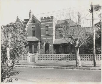
Photograph, House, cnr Fellows & Princess Streets, circa 1965, c. 1965
... and this was therefore one of the first of the many buildings he was to design... and this was therefore one of the first of the many buildings he was to design ...17 Fellows Street Kew was originally owned and occupied by the architect Henry Kemp. Kemp had arrived in Australia in 1886 and this was therefore one of the first of the many buildings he was to design in Melbourne. While late Victorian in date, the house is an interesting precursor of the Edwardian architecture produced by Kemp. Somewhat awkwardly composed with steep gables, a rectangular castellated tower and slated single storeyed verandahs projecting from the overall box-like form, the house contains features common to the 1880s such as the use of polychromy in the brickwork and slates cladding the roof. (Sanderson 1988). The historian Dorothy Rogers established that at one stage it was the home of Dr John Dale - Chief Medical Officer of the City of Melbourne. This photograph predates later renovations to the rear of the property.This work forms part of the collection assembled by the historian Dorothy Rogers, that was donated to the Kew Historical Society by her son John Rogers in 2015. The manuscripts, photographs, maps, and documents were sourced by her from both family and local collections or produced as references for her print publications. Many were directly used by Rogers in writing ‘Lovely Old Homes of Kew’ (1961) and 'A History of Kew' (1973), or the numerous articles on local history that she produced for suburban newspapers. Most of the photographs in the collection include detailed annotations in her hand. The Rogers Collection provides a comprehensive insight into the working habits of a historian in the 1960s and 1970s. Together it forms the largest privately-donated collection within the archives of the Kew Historical Society17 Fellows Street, Fellows Street frontage."17 Fellows St. Also residence of Dr. John Dale, Melbourne City Medical Officer"fellows street (kew), dorothy rogers, henry kemp, dr john dale -
 Wodonga & District Historical Society Inc
Photograph - Wodonga old Railway Station complex
... November 1873 the first station building, which included... the first station building, which included a refreshment room ...\When the railway reached Wodonga from Melbourne on 19th November 1873 the first station building, which included a refreshment room and dining room, was a temporary structure. It was 300 ft. long and was removed and taken to Beechworth when the new station was built in 1874 by contractor J. Richardson. The Goods shed was 100 feet long and was built by Frew & Hill in 1873. One year later it was extended an additional 150 feet by James Nation. The date of the construction of the Locomotive shed is not known but predates 1883. It was a galvanised iron clad building which housed 4 engines on 2 tracks; in 1910 it was extended to 250 feet in length to house six more engines. The location of the railway tracks and station were a constant cause of congestion in the centre of Wodonga as the tracks crossed over Sydney Road (later named High Street). Lines of traffic were frequently banked up as the gates were closed to allow trains to cross. The Wodonga Rail Bypass project moved Wodonga station from the original central location to a position on a new line on the northern edge of the town. Not only did this release land in the middle of the city for commercial and public use, but also eliminated 10 level crossings. The project actually commenced in 2008 with the last passenger train passing through Wodonga on 8 November 2008. On 23 July 2010, the new rail bypass was opened, the original line through Wodonga closed and the station fell quiet. The area has now been redeveloped as Junction Place and the old buildings now house a restaurant, cafe and the Goods Shed Craft Beer Cafe.These images are of local, state and national significance as the Wodonga Railway complex formed a vital link in the Victorian state, interstate and national railway system.A collection of colour photos of the buildings at the former Wodonga Railway Stationwodonga railways, railway station wodonga, junction place wodonga -
 Orbost & District Historical Society
hat stretcher, first half 20th century
... as well as in Melbourne at Myers and David Jones. The building... as well as in Melbourne at Myers and David Jones. The building ...Prior to the 1960s, hats were worn by all men. Aluminium hat stretchers were generally in use from the 1920’s. The hat was placed on the aluminium dome shaped piece. When the handle was turned, the dome section split vertically, one section moving away from the fixed half. A graduated scale along the side indicated the size. This item was possibly used in the hat factory in Orbost. Stuart Hats commenced manufacturing hats in about 1948 and closed their factory in Orbost around 1953 probably because of the high transport costs. The company's head factory was in Melbourne. The hats made in Orbost were sold all over Australia as well as in Melbourne at Myers and David Jones. The building became first a Dry Cleaners and then a private home.This item was possibly used by Stuart Hats which was a significant manufacturing business in Orbost in the 1950's employing nearly 20 local people.A hat stretcher consisting of an aluminium dome-shaped piece (on which the hat was placed) and a metal winder. It has been mounted onto a wooden baseOn wooden base : "Restored by John Mundy"millinery hats hat-stretcher -
 Linton and District Historical Society Inc
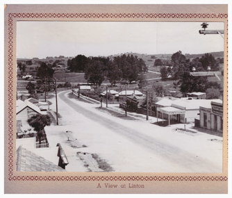
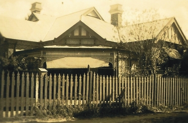
Postcard, A View at Linton, Sussex Street, Linton, view to south, circa 1940
... to it, and the first Bank of NSW building. Two houses are further down the road..., a house next to it, and the first Bank of NSW building. Two houses ...The "Lorna, Bob and Elsie" in the inscription are probably Elsie McCorkell, her son Robert Hayward, and her daughter Lorna McCorkell.A very small photograph which has been made into a souvenir/postcard. The photograph is a view of Sussex Street, Linton, looking south-west. On the right of the photo are Ching's store, R. N. Sandow confectionery shop, a house next to it, and the first Bank of NSW building. Two houses are further down the road past Gillespie Street. On the left of the photo are the Edinburgh Bakery and a store with a verandah on the corner of Gillespie Street. The photograph is glued to a beige-coloured card which has a decorative edge cut into it. A printed border surrounds the photograph, and the words "A View at Linton" are printed underneath it. The card appears to have had the right-hand edge trimmed with scissors. Because of this, an inscription on the back of the card has been partially cut away. The inscription reads "-rs Whitehand & Doris / -with love from Lorna, Bob and Elsie".sussex street linton, buildings, shops, houses, sandow shop, ching's store, edinburgh bakery, postcards, souvenirs, lorna mccorkell, robert hayward, elsie mccorkell -
 Eltham District Historical Society Inc
Book, Kristin Otto, Yarra : a diverting history of Melbourne's murky river / Kristin Otto, 2005
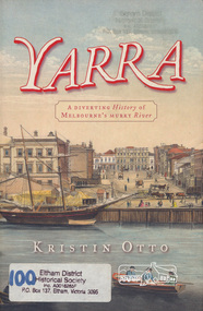
... to the headwaters) to the twenty-first-century waterside building boom, Otto... to the headwaters) to the twenty-first-century waterside building boom, Otto ..."It was John Wedge, Batman's private surveyor, who named the Yarra Yarra. In September 1835 he was at the Turning Basin with some Kulin and heard them identify the river as it came over the Falls as, he wrote, 'Yarrow Yarrow'. It was only some months later that Wedge discovered they had been referring to the pattern and movement of water over the Falls, not the river itself. And ever since, it has been the Yarra's fate to be misunderstood: maligned for its muddiness, ill-used as sewer and tip; scooped, sculpted, straightened and stressed, 'cleaned up' to the detriment of its natural inhabitants; built-over, under and beside; worked mercilessly and then bridged almost to maritime extinction. In Kristin Otto's superbly entertaining new history, the whole sorry tale is laid bare. From the creation stories of Kulin owners and geologist blow-ins (and Robert Hoddle's bad-tempered expedition to the headwaters) to the twenty-first-century waterside building boom, Otto traces the course of Melbourne's murky river. Erudite, affectionate and witty, with more meanders and diversions than the river itself, Yarra is both a fascinating read and a fitting tribute to the 'noble stream'." -- Publisher's website.Paperback; [viii], 245 p. : illus., maps ; 24 cm.ISBN 1920885781yarra river -
 Eltham District Historical Society Inc
Photograph, Brocksopp House (1860)
... known as Souters Cottage Eltham's first mud brick building... known as Souters Cottage Eltham's first mud brick building ...Image No. 1 Brocksopp House erected about 1860 Originally known as Souters Cottage Eltham's first mud brick building Falkiner's Cottage The Alistair Knox Collection The Alistair Knox Collection is a series of mounted enlarged photos of mud brick houses and related subjects. The collection is understood to have been put together by Alistair Knox although it is the work of several unacknowledged photographers. For some years it was held by the Building Department of the former Eltham Shire Council and was then passed to our Society for safekeeping. Some of the photos have been used in Knox's books and from time to time some of them have been part of various historical displays. As far as we know there has not been a public display of the whole collection which numbers about forty photographs. The collection has been copied on to slides for the purpose of this meeting and to be retained as part of the Society's pictorial collection. Alistair Knox 1912 - 1986 is acknowledged as the founder of Eltham's mud brick building movement. Many of the buildings shown in the collection are of his design and he was also involved with the construction of several of them. Others are the work of his contemporaries and associates such as Peter Glass, Gordon Ford, and John Harcourt. (EDHS Newsletter No. 145 July 2002)Handwritten notes in pencil re details of building, year of construction, owner, designer, builder, etcbrocksopp house, falkiner cottage, houses, mud brick construction, souters cottage, alistair knox collection -
 Kew Historical Society Inc
Archive (Sub-series) - Subject File, Kew Historical Society, Holy Trinity Church, 1899
... ’ (1963), ‘150th Anniversary of the First Service in this Building... of the First Service in this Building March 5, 1863’ (2013). Other ...Various partiesReference, Research, InformationSecondary valuesA large subject file containing original primary sources and a range of secondary sources including published and unpublished histories of the church or its parts. The earliest item is a Sunday School Association Certificate issued to Amy Grigg in 1899. Publications by the Church include ‘Holy Trinity Church Kew Jubilee Souvenir 1863-1913’ (1913) [which includes a chronicle of events], ‘Holy Trinity Church Kew 70 Years 1863-1933), ‘Holy Trinity Church Kew Restoration and Continuity of Worship - Stewardship Review’ (1974), ‘Centenary Holy Trinity Church of England Kew’ (1963), ‘150th Anniversary of the First Service in this Building March 5, 1863’ (2013). Other published histories include two copies of: McFarlane, G., Memories in Glass: Holy Trinity Anglican Church, Kew. The file also includes unpublished monographs about the church (Mavis Rolley, 1980). The file also includes various leaflets and orders of service.holy trinity church - kew (vic), high street - kew (vic), rev rowland hayward, very rev dean vance dd, archdeacon hindley bd, rev canon sutton bd, sir william stawell, charles barrett, rev f a townshend, trinity grammar school, ruyton girls school, rev gordon brown, most rev philip freier, ferguson & urie, stained glass - kew (vic), amy griggholy trinity church - kew (vic), high street - kew (vic), rev rowland hayward, very rev dean vance dd, archdeacon hindley bd, rev canon sutton bd, sir william stawell, charles barrett, rev f a townshend, trinity grammar school, ruyton girls school, rev gordon brown, most rev philip freier, ferguson & urie, stained glass - kew (vic), amy grigg -
 Ringwood and District Historical Society
Letter, Letter written by H.C.Howship to Ringwood Mail Ringwood 1963
... to build some of the first buildings in that property now known... of the first buildings in that property now known as Ringwood Timber ...To the Editor of the Ringwood Mail Dear Sir, would you please publish in your widely read paper the following letter for the information of the residents of the City of Ringwood- Re the passing of my brother Mr. J.P. Howship, who was an ANZAC one of the pioneer family of Howship of Ringwood which name is connected with the early history of Ringwood or more particularly Ringwood East as the late J.P. Howship and myself purchased the Nursery of Mr. John Hill around the year 1912 and after a couple of years my late brother Bert was taken into partnership and we bought the adjoining nursery of Mr. Will Hill and traded under name Howship Bros. Rosedale Nursery and the name of one street in the old property Howship Avenue is named after the old firm as well as Rosedale Crescent. The move for the establishment of the Ringwood East station started with myself and in a meeting up with a Mr .T. Birkitt who I felt was the man I needed as he was a sub Estate Agent .A meeting was called and held in our packing shed at the end of Federal Road which at that time ended at Mr. Charlie Burdens property and abbuted (sic) on our property. This meeting was attended by about sixty residents and the late Mr. C. Wedge was elected as the first President of the Ringwood East Railway League and Progress Assoc. with Mr. T. Birkitt as Secretary and myself as assist. Secretary. This League raised the sum of about 1,600 from residents and land owners for the erection of the Ringwood East Railway Station & after the station was erected and paid for the League part was canceled and the Progress Assoc. carried on. The present Ringwood East Cricket Club was formed at meeting and the Prog .......and my three brothers Bert, Mervyn and played cricket in the Ringwood district for many years and most of us were members of the Ringwood at first and then the Ringwood East Football clubs and followed the teams for years a few names of the old players came to mind in E. Thomas , C. Weil, T. Homewood, the Pratt family and others. I might mention for the benefit of the City of Ringwood residents my eldest brother Laurie late of New Street and now living at Blairgowrie was with what was then known as Coopers Mills and designed and helped to build some of the first buildings in that property now known as Ringwood Timber & Trading Co .Also that myself and others namely the Reidy Brothers, Mr. Taylor, & L .Cleary & voluntary labour formed the tennis courts at East Ringwood with the help of our young Ladies of the time, those courts I'm pleased to say are well established and two more are added and provide good activities for the young people of the district. Also with the aid of C .Thomas, Norm Blood and others we formed the Methodist courts. From the Ringwood East Progress Association came the move to have a Health Centre for Ringwood. This was established by a good deal of enthusiastic work by some mothers after spending nearly fifty years in Ringwood watching it grow from town surrounded by orchards to a City and I must congratulate the Civic Fathers and their staff in the growth of Ringwood and the fine roads, Parks, Elderly Citizens Club and have all done a good job but why oh why have you neglected mines Road Ringwood east. Why has this road not been made the drainage there is something to be seen to be believed in such a city .The only solution is making and curbing this road & I would ask those responsible why the curbing was put down Dublin Road where there are no residents this curbing could well have solved the problem in Mines Road if used there. I recently spent a weekend with my Daughter, Mrs. Munro at the corner of Maroondah highway and Mines Road and was disgusted at the condition of Mines Road and drainage and had to air my views and suggest a trip to Mines Road by the Civic Fathers led by the Health Inspector I am yours sincerely H.C. Howship Sheila Street, Rye. (copied here verbatim)3 pages of hand written letter detailing the early history of the East Ringwood Railway and Progress Association, football, cricket and tennis clubs.. Written as a draft in 1963. -
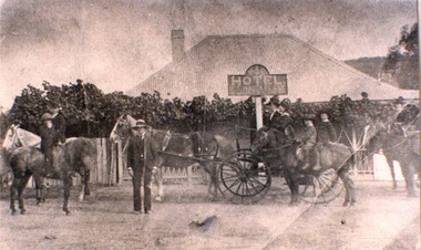 Wodonga & District Historical Society Inc
Photograph - Mac's Hotel, Wodonga, c1870s
... Agency business. He was appointed Secretary to the first Wodonga... was appointed Secretary to the first Wodonga Building Society. W. C ...“Mac's Hotel" in Wodonga West, one of Wodonga's earliest hotels, was owned by William Christie McFarlane who arrived in Melbourne in December 1854 from Stirling, Scotland. He spent his first three years mining for gold at Beechworth. For the next three years he was the manager of the King’s Hotel at Wooragee, which was owned by his father-in-law, Charles David King. In 1860 he bought 180 acres of land at Wodonga, eventually extending his holdings to 1,000 acres on which he farmed. He called his property “Abbey Craig” after his home in Scotland. In time he owned several properties in Wodonga, a small vineyard and 'Mac's Hotel'. Mac’s Hotel was a popular meeting place for teamsters and other travellers on the Sydney Road. It opened in the early 1860s and the license was at times in the name of W. C. McFarlane and at other times held by his wife, Mary McFarlane. William had several positions during his life in Wodonga including serving as Postmaster and conducting a Commission and Insurance Agency business. He was appointed Secretary to the first Wodonga Building Society. W. C. McFarlane also filled the position of Sheriff’s Officer, Registrar of Births and Deaths and Marriages, and Justice of the Peace. W. C. McFarlane served as a member of the Wodonga Shire Council for several years including three terms as Shire President: 1889-90, 1890-1891 and 1894-95. He passed away in Wodonga in December 1906. After his death, the license of Mac’s Hotel continued to be held by Mary McFarlane until her death in November 1910. The license was not renewed and the hotel was taken over as a residence by their son, Walter McFarlane. Unfortunately, on 25 January 1913, Walter was assisting neighbours fighting grass fires about 3 miles away when his own home was completely destroyed by fire, bringing to an end the long history of the popular hostelry, Mac’s Hotel.This image is significant because it documents an early business in Wodonga conducted by a prominent Wodonga resident.Black and white image of people standing, on horseback and in coach outside Mac' Hotel, West Wodongamac's hotel, hotels wodonga -
 Federation University Historical Collection
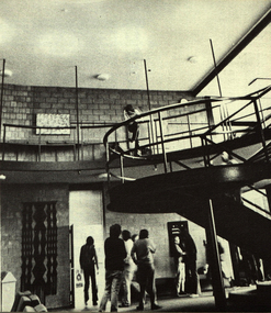
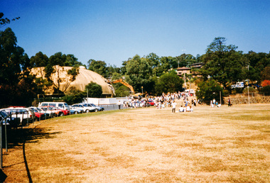
Photograph, The Knuckle at Gippsland Institute of Advanced Education, c1976
... to the first of its permanent buildings on a large campus in rural... to the first of its permanent buildings on a large campus in rural ...The Gippsland Institute of Advanced Education was established by an Order-in-Council in September 1968. The Council of the Institute included members of the Gippsland community who are prominent in local government, industry, commerce, education and the professions, the Director of the Institute, and representatives of the academic staff, students, and graduates. On its establishment, the institute assumed responsibility for the diploma courses previously offered by the Yallourn Technical College which had commenced diploma teaching in 1929. Initially, all the Institute's teaching was conducted in the diploma building of the Yallourn Technical College. In 1972 the Institute transferred part of its operations to the first of its permanent buildings on a large campus in rural surrounds near the township of Churchill, ten kilometres south of MOrwell and one hundred and sixty kilometres east of Melbourne. The Gippsland Institute of Advanced Education was opened on 20 November 1976 by the Honourable Lindsay Thompson, Deputy Premier of Victoria and Minister of Education; and Senator J.L. Carrick, Minister for Education in the Commonwealth Government. Image of an area in the Gippsland Institute of Advanced Education known as The Knuckle.gippsland institute of advanced education, gippsland campus collection, the knuckle, churchill -
 Federation University Historical Collection
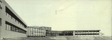
Photograph, Gippsland Institute of Advanced Education Ampitheatre, c1976
... to the first of its permanent buildings on a large campus in rural... to the first of its permanent buildings on a large campus in rural ...The Gippsland Institute of Advanced Education was established by an Order-in-Council in September 1968. The Council of the Institute included members of the Gippsland community who are prominent in local government, industry, commerce, education and the professions, the Director of the Institute, and representatives of the academic staff, students, and graduates. On its establishment, the institute assumed responsibility for the diploma courses previously offered by the Yallourn Technical College which had commenced diploma teaching in 1929. Initially, all the Institute's teaching was conducted in the diploma building of the Yallourn Technical College. In 1972 the Institute transferred part of its operations to the first of its permanent buildings on a large campus in rural surrounds near the township of Churchill, ten kilometres south of MOrwell and one hundred and sixty kilometres east of Melbourne. The Gippsland Institute of Advanced Education was opened on 20 November 1976 by the Honourable Lindsay Thompson, Deputy Premier of Victoria and Minister of Education; and Senator J.L. Carrick, Minister for Education in the Commonwealth Government. The Gippsland Institute of Advanced Education ampitheatregippsland institute of advanced education, gippsland campus collection, churchill, ampitheatre, buildings -
 Federation University Historical Collection
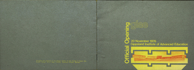
Booklet, Gippsland Printers, GIAE Official Opening, 1976, 1976
... to the first of its permanent buildings on a large campus in rural... to the first of its permanent buildings on a large campus in rural ...The Gippsland Institute of Advanced Education was established by an Order-in-Council in September 1968. The Council of the Institute included members of the Gippsland community who are prominent in local government, industry, commerce, education and the professions, the Director of the Institute, and representatives of the academic staff, students, and graduates. On its establishment, the institute assumed responsibility for the diploma courses previously offered by the Yallourn Technical College which had commenced diploma teaching in 1929. Initially, all the Institute's teaching was conducted in the diploma building of the Yallourn Technical College. In 1972 the Institute transferred part of its operations to the first of its permanent buildings on a large campus in rural surrounds near the township of Churchill, ten kilometres south of Morwell and one hundred and sixty kilometres east of Melbourne. The Gippsland Institute of Advanced Education was opened on 20 November 1976 by the Honourable Lindsay Thompson, Deputy Premier of Victoria and Minister of Education; and Senator J.L. Carrick, Minister for Education in the Commonwealth Government. Silver and yellow soft covered booklet celebrating the opening of the Gippsland Institute of Advanced Education at Churchill, Victoria. An introduction is written by C.H. Ford, President of Council. The book was designed and produced by the design Centre, G.I.A.E. SChool of Visual Arts.gippsland institute of advanced education, m.w. hopper, c.h. ford, lindsay thompson, j.l. carrick, r.w. muncey, churchill, yallourn, morwell, yallourn technical school, yuncken freeman architects, f.a. gray, f.r. goddard, j. milton-smith, j.r. lawry, b.r. groves, c.p.a. hos, c.w. tolley, k.f. smith, j. dowsley, robert charles bigelow, charles hartley ford, daniel eric kent, barbara lapin, john charles mcgauran, neville thompson, john charles vinall, leslie alfred galvin, maxwell francis gray, john alfred forster oram, donald robert hannington, john perrin kellaway, john james robertson, leslie lawrence shipp, valerie lorraine willington, leonard allan falk, kwong chiu lee dow, brenton robert groves, glen william drover, kenneth francis gibson, maxwell wallace hopper, teunis jan geerit korevaar, j.j. robertson, d.f. kretlow, chancellor and patrick, churchill campus, gippsland campus collection -
 Orbost & District Historical Society
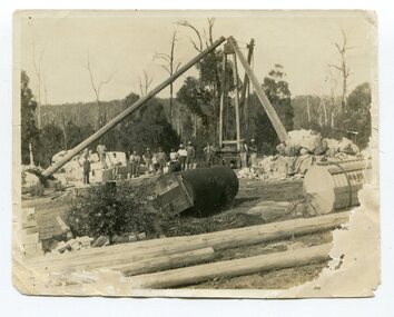
black and white photograph, first half 20th century
... the building’s first foundation stone in 1913 but it was not until August... the building’s first foundation stone in 1913 but it was not until August ...This photograph shows men working on cutting marble at South Buchan for Australia House in London. In the early 1900s black marble was being mined in the Bruthen district. Some was used for the Shrine of Remembrance in Melbourne and Australia House in London. 900 tonnes were shipped to London to be included in the construction of Australia House. DESCRIPTIONA paper covered booklet which is a pictorial souvenir Of Australia House in London. Pictures show Buchan marble features of the building.SIZE H-266mm W-192mm OBJECT REGISTRATION654KEYWORDSbuchan-marble australia-houseHISTORICAL INFORMATIONAustralia House is the oldest Australian diplomatic mission and it is the longest continuously occupied foreign mission in London. King George V laid the building’s first foundation stone in 1913 but it was not until August 1918 that he officially opened the completed building. The stringencies of World War I – principally shipping difficulties and labour shortages – had delayed construction considerably. Federation of the six Australian states formally took place on 1 January 1901 but it was not until 1906 that the Federal Government sent an Official Secretary to London to represent Australia. In the intervening years Australia was represented by State Agents-General, the first of whom was the Agent-General of Victoria. The building is significant for its unique design, Beaux Arts style and the materials used in its construction.Marble quarrying has been a significant part of the history of Buchan in East Gippsland. Its inclusion in Australia House in London and the shrine of Remembrance in Melbourne is noteworthy.A small black / white photograph of men in the background of a marble quarry. There is also a copy.on back - " Cutting Australian Home Marble at Sth Buchan"buchan-marble geology australia-house -
 Eltham District Historical Society Inc
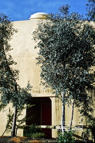
Photograph, Pise building, Montsalvat (1934-1935)
... First Montsalvat pise building, Built 1934-35, Designed...First Montsalvat pise building, Built 1934-35, Designed ...First Montsalvat pise building, Built 1934-35, Designed by Justus Jorgensen, Founder of Montsalvat. This building was used for many years as a dining room and kitchen. The Alistair Knox Collection (Image 2A) The Alistair Knox Collection is a series of mounted enlarged photos of mud brick houses and related subjects. The collection is understood to have been put together by Alistair Knox although it is the work of several unacknowledged photographers. For some years it was held by the Building Department of the former Eltham Shire Council and was then passed to our Society for safekeeping. Some of the photos have been used in Knox's books and from time to time some of them have been part of various historical displays. As far as we know there has not been a public display of the whole collection which numbers about forty photographs. The collection has been copied on to slides for the purpose of this meeting and to be retained as part of the Society's pictorial collection. Alistair Knox 1912 - 1986 is acknowledged as the founder of Eltham's mud brick building movement. Many of the buildings shown in the collection are of his design and he was also involved with the construction of several of them. Others are the work of his contemporaries and associates such as Peter Glass, Gordon Ford, and John Harcourt. (EDHS Newsletter No. 145 July 2002)Handwritten notes in pencil re details of building, year of construction, owner, designer, builder, etcmontsalvat, houses, justus jorgensen, pise construction, alistair knox collection -
 Kew Historical Society Inc
Plan, Melbourne & Metropolitan Board of Works : Borough of Kew : Detail Plan No.1573, 1905
... as a ‘modern school of the first order’ with buildings that formed... of construction materials used in buildings in the first decade ...The Melbourne and Metropolitan Board of Works (MMBW) plans were produced from the 1890s to the 1950s. They were crucial to the design and development of Melbourne's sewerage and drainage system. The plans, at a scale of 40 feet to 1 inch (1:480), provide a detailed historical record of Melbourne streetscapes and environmental features. Each plan covers one or two street blocks (roughly six streets), showing details of buildings, including garden layouts and ownership boundaries, and features such as laneways, drains, bridges, parks, municipal boundaries and other prominent landmarks as they existed at the time each plan was produced. (Source: State Library of Victoria)This plan forms part of a large group of MMBW plans and maps that was donated to the Society by the Mr Poulter, City Engineer of the City of Kew in 1989. Within this collection, thirty-five hand-coloured plans, backed with linen, are of statewide significance as they include annotations that provide details of construction materials used in buildings in the first decade of the 20th century as well as additional information about land ownership and usage. The copies in the Public Record Office Victoria and the State Library of Victoria are monochrome versions which do not denote building materials so that the maps in this collection are invaluable and unique tools for researchers and heritage consultants. A number of the plans are not held in the collection of the State Library of Victoria so they have the additional attribute of rarity.Original survey plan, issued by the MMBW to a contractor with responsibility for constructing sewers in the area identified on the plan within the Borough of Kew. The plan was at some stage hand-coloured, possibly by the contractor, but more likely by officers working in the Engineering Department of the Borough and later Town, then City of Kew. The hand-coloured sections of buildings on the plan were used to denote masonry or brick constructions (pink), weatherboard constructions (yellow), and public buildings (grey). This plan has detailed annotations written in red or blue ink, showing prices, which may be the annual valuations of the properties, and some owners’ names, a most unusual feature on contractor's maps. Some areas, such as the buildings of Methodist Ladies’ College (MLC), include the school’s tennis court and swimming pool, but are not coloured to show building materials – did the draftsman just run out of time, or ink, or enthusiasm, before his plan had to be submitted? MLC had been founded in 1882 as a ‘modern school of the first order’ with buildings that formed ‘a collegiate institution for girls unsurpassed in the colonies’. The goal of its founders was to provide a high-class Christian education for girls, comparable with that provided elsewhere for boys. Some shops are shown along Edgevale Road, though they are not designated as commercial premises. Larger houses are depicted, including ‘Fairlawn’ in Barkers Road, and ‘Clevedon’ and ‘Rosehill’ (now demolished) in Fitzwilliam Street.melbourne and metropolitan board of works, detail plans, mmbw 1573, maps - borough of kew, cartography -
 Eltham District Historical Society Inc
Folder, Eltham Obelisk (later Cenotaph), 1918-2018
... was to be the first of three buildings of the Eltham War Memorial to be built... was to be the first of three buildings of the Eltham War Memorial to be built ...The Eltham Obelisk was originally located at the corner of Bridge and Main Roads in 1919. In 1943 (WW2) the local community commenced plans to establish the Eltham War Memorial, a living memorial to benefit the children as opposed to a one in stone as per the obelisk. The Eltham War Memorial Trust was established in 1945. In 1947 the Trust intended for the Obelisk to be relocated from Bridge Street and Main Road to the Garden of Remembrance which was planned as part of the Baby Health Centre which was to be the first of three buildings of the Eltham War Memorial to be built in 1951. In 1951 the Eltham RSL was invited to be represented on the Eltham War Memorial Trust. Around this time, with pending roadworks, the obelisk was relocated to the front garden of the Eltham RSL sub branch on Main Road for safe keeping. In 2007, a suggestion was proposed by Harry Gilham (President, EDHS) to John Cohen (ERSL) to claim a special site along with the historic Shillinglaw trees on the now vacant former Eltham Shire Office site adjacent to the Eltham War Memorial precinct for relocation of the obelisk. In 2010 following the financial collapse and sale of the Eltham RSL Sub-Branch property and amalgamation with the Montmorency Eltham RSL sub-branch, the location of the obelisk was again in immediate jepoardy and in conjunction with Nillumbik Shire Council, the obelisk was relocated in front of the Eltham War Memorial buildings in preparation for the Dawn Service on Anzac Day 2012. Contents: Newspaper article: Eltham Obelisk of 1919, Harry Gilham, August 2000 as well as draft submitted dated 22 Aug 2000 Newspaper article: Eltham, The Advertiser 15 Nov 1918 and 18 Nov 1918 Newspaper article: An Obelisk at Eltham, The Advertiser, 11 Jul 1919 Newspaper advertisement: Unveiling of Obelisk at Eltham, The Advertiser, 1 Aug 1919 Newspaper article: Eltham Soldiers’ Memorial; Unveiled by Sir William Irvine, The Argus, Monday, 4 Aug 1919, p8 Newspaper article: Eltham Memorial to Fallen Soldiers, Diamond Creek Valley Advocate, 8 Aug 1919 Newspaper article: Memorial to the Fallen; Unveiled at Eltham, The Age, Monday, 4th August 1919 Newspaper article: Programme - Presentation of German Machine Gun at the Obelisk, Eltham on Sunday, 8th August, 1920, at 3.30 P.M. Newspaper article: article about presentation of a war trophy, a heavy machine gun placed beside obelisk, The Advertiser, 13 Aug 1920 Newspaper article: Eltham: ANZAC Services, The Advertiser, Friday, May 2, 1924 Newspaper article: Eltham War Memorial, The Advertiser, Oct 26, 1928 Handwritten note from Harry Gilham (President EDHS) to John Cohen (ERSL) regarding history of Eltham RSL site and 1947 newspaper article "Eltham War Memorial Trust "Garden of Remembrance" referencing relocation of Obelisk to the proposed Garden of Remembrance at the Baby Health Centre (Eltham War Memorial). Officers' reports, 11.113/10 Relocation of Eltham RSL Cenotaph, Nillumbik Shire Council Ordinary Meeting, 21 December 2010 Email Correspondence: EDHS President to NSC General Manager Community and Leisure re RSL Obelisk (Cenotaph) proposed relocation, 24 May 2011 Newsletter Extract: Eltham RSL and War Memorial, EDHS Newsletter 14 Sep 2011 Officers' reports, OCM.091/11 Interim Relocation site for the Eltham Cenotaph, Nillumbik Shire Council Ordinary Meeting, 23 August 2011 Officers' reports, OCM.004/121 Interim Relocation of the Eltham Cenotaph, Nillumbik Shire Council Ordinary Meeting, 31 January 2012 (includes Funding agreement between NSC and Montmorency-Eltham RSL Sub-branch Inc) Newspaper article: Move war memorial: RSL, c.2011 Newspaper article: Memorial move lags, Diamond Valley Leader, 1 February 2012 Newspaper article: New dawn for tribute, Diamond Valley Leader ca April 2012 Open letter to the residents of Eltham and Montmorency and copies of drafts by the Montmorency Eltham RSL, no date and final version published in Diamond Valley New 21 March 2012 and Banyule & Nillumbik Weekly, 27 March, 2012 Newspaper article: RSL site nets $1.8m, Diamond Valley Leader, 9 May 2012 Newspaper article: Memorial Moved, Banyule/Nillumbik Weekly, 10 April 2012 Newspaper article: Eltham cenotaph move goes 'like clockwork', Diamond Valley Leader, 11 April 2012 Advertisement, Program for Eltham Dawn Service, Diamond Valley Leader, April 2012 Newspaper photo: Veterans (l-r) Alan Field, Max Lowerson and John Cohen will join piper David Cretney to commemorate fallen Diggers, 2012 (standing beside relocated obelisk in front of the Eltham War Memorial complex) Program for Montmorency Anzac Day March 2012 (incomplete, some pages duplicated, some pages upside down). Newspaper article: Plan to expand memorial, Diamond Valley Leader, Sep. 2004, p5 Newspaper article: Names renewal, thanks to Barry, Diamond Valley Leader, 18 Apr 2007, p3 with picture featuring Eltham RSL president John Haines and Gwen Rosewall Letter: EDHS President to Manager Community Participation, Learning and Culture, Nillumbik Shire Council regarding a proposal by the Montmorency-Eltham RSL Sub-branch to expand the area occupied by the relocated obelisk further into the Eltham War Memorial Garden of Remembrance, 18 Aug 2014 Notices of Motion, NOM.001/14 pertaining to memorials Advisory Committee and Montmorency-Eltham RSL to upgrade the Eltham War Memorial site in time for ANZAC Day 2015, Nillumbik Shire Council Ordinary Meeting, 26 August 2014 Agenda: User Groups and Stakeholders Meeting, Proposed Extension to Memorial Terrace, 11 September 2014 EDHS presentation to NSC Policy and Services meeting 9 September 2014 regarding the Montmorency-Eltham RSL proposal to expand/upgrade the Eltham War Memorial Policy and Services reports, PSD.034/14 Eltham War Memorial Building Precinct - Proposed Extension to Memorial Terrace, Nillumbik Shire Council Ordinary Meeting, 9 September 2014 Email (copy): President EDHS re Eltham War Memorial Complex, Main Road, Eltham, 15 Sep 2014 requesting Nillumbik Shire Council place a Heritage Overlay upon the Eltham War Memorial Complex Media Release: Support for cenotaph expansion, Nillumbik Shire Council, Sep 2014 Newspaper article: Council defers RSL war memorial upgrade to see consultation, Diamond Valley News, 17 Sep 2014 Letter (copy): Harry Gilham, Eltham to local press and others, 20 Sep 2014 protesting attempts by the RSL to further expand upon the area already ceded from the Eltham War Memorial for the relocated WW1 obelisk and alter the original vision for an Eltham War Memorial complex. Letter: Alan Field, President, The Eltham Veterans War Memorial Preservation Society Inc. to CEO and Councillors, Nillumbik Shire Council protesting at perceived injustices and ‘veteran bashing’ regarding their previous efforts to relocate ‘their Obelisk and Cenotaph’ to the Eltham War Memorial complex and their frustration in their attempts to further expand upon the Memorial Terrace. Areas of letter are highlighted with handwritten markups and notes. Also notes on loose card and paper with definitions of Memorial, Obelisk, Cenotaph, commentary on establishment of Eltham War Memorial, The Eltham War Memorial Trust and RSL involvement and current actions by RSL in respect to claims in the letter (written by Harry Gilham ?). Policy and Services reports, PS.038/14 Eltham War Memorial Building Precinct - proposed extension to the Eltham Cenotaph Terrace, Nillumbik Shire Council Policy and Services Committee Meeting, 14 October 2014 Newspaper article: Centenary dawn service moves to Petrie Park, Diamond Valley Leader, 22 Oct 2014 Newspaper article: Upset over upgrade; war memorial revamp plans get culled, Diamond Valley Leader, 29 Oct 2014 Newspaper article: Memories of our heroes, Diamond Valley Leader, 25 Apr 2018 – also Veteran saluted, featuring article on Army veteran, Glen Ferrarotto. Handwritten notes in pencil (2 pages) by Harry Gilham, Items form the Eltham and Whittlesea Shires The Advertiser newspaper 7 June 1918 - 1919 providing a summary of the formation of the Peace Celebration Committee leading to the establishment of the Avenue of Honour and the Eltham Obelisk Newspaper article: Obelisk honors their memory, Diamond Valley News, March 30, 1971, p11eltham cenotaph, nillumbik shire council, eltham war memorial, montmorency eltham rsl sub-branch, dawn service, cenotaph, eltham rsl sub-branch, eltham war memorial trust, garden of remembrance, harry gilham collection, john cohen, obelisk, remembrance garden, shillinglaw trees, german machine gun, war memorial, war trophy -
 Federation University Historical Collection
Photograph, N.l. Harvey & Son, Mount Helen Campus, 1968, 1969
... Gear Avenue .7) Ground level view. First columns of E building... view. First columns of E building. .13) Mt Helen development ...The Federation University campus at Mount Helen was first used by students in 1970.Seven photographs of the Mt Helen Campus Stage one development. .1) Aerial view of foundation work, from west, towards Green Hill .2) Aerial View from South. Earthworks and foundations .3) Aerial View from south west. Earthworks, general view .4) Aerial View from above the South West corner of E building. .5) Aerial View from North East. Gear Avenue in background .6) Aerial View from North West. Earthworks extend from Gear Avenue .7) Ground level view. First columns of E building. .13) Mt Helen development Stage One, Engineering Diploma Buildings. This image shows the wall beam and pier construction to the East Wall of the Fluid Mechanics Laboratory adjacent to the pump chamber, 17 June 1968. .18) Flume Pit and Pump Chamber, 15 July 1968. .28) East Wing Pit Looking North, 26 August 1968 .40) Construction as of 04 November 1968federation university, federation university australia, feduni, university of ballarat, ballarat college of advanced education, ballarat institute of advanced education, building, earthworks, foundation, early development, soil testing laboratory -
 Eltham District Historical Society Inc
Photograph, Demolishing the Bini Shell at Diamond Creek, 1991, 1991
... on the building’s circular base, on the top of a fabric bladder. 300 tonnes... by L.P. Jan 2022 This was the first public building in Victoria ...In 1978 Diamond Valley Shire recognised the need for a new public hall in Diamond Creek. Council considered the Bini shell form of construction which was in operation overseas and in use in New South Wales as libraries, gymnasiums, sports centres and multi-purpose centres. The Council gave the go-ahead. A site was chosen opposite the Hotel and close to the railway line. One day in - the following year, in 1979, activity stood still in Diamond Creek as school children and other excited spectators watched the one-hour inflation of the Bini Shell. This unusual method of construction was invented by Italian industrial designer and architect Dante Bini. The construction pneumatically raises a level of reinforced concrete from ground level which has not been set, using an internal balloon. The inner membrane inflates and compresses the mesh and concrete against the outer membrane. A net of flexible steel rods was laid on the building’s circular base, on the top of a fabric bladder. 300 tonnes of reinforced concrete were poured onto the mesh and a sealed cover laid over the concrete making a sandwich of cover, bladder and mesh. Compressed air was pumped into the bladder and the sandwich slowly began to rise and become a massive self-supporting dome. After inflation and removal of the outer membrane workmen filled in any holes. It was some days before pneumatic drills pecked out the first opening. The ceiling of the concrete dome was lined with fluffy insulating material. The dome was 36 metres in diameter at the base and 12 metres high in the centre with a usable floor space of 670 square metres. An opening night dinner was held to celebrate the new facility on March 12, 1980. Shire President Ron Pata made a speech and unveiled a plaque. It was the first public building in Victoria to be erected using the Bini Shell design method of construction The facility could cater for up to 400 people and in 1980 a fee for use was $100 for up to 200 people, $150 for up to 300 people and $200 for up to 400 people. For the next ten years or so, locals attended the hall for marital arts classes, basketball and netball games and school discoes and various other activities. After pieces of concrete fell off a Bini shell interstate due to a construction fault, the Council closed the centre. Demotion took place during the Diamond Creek Town Fair in 1991, as part of the annual Town Fair’s program. Research by L.P. Jan 2022This was the first public building in Victoria to be erected using the Bini Shell design method of construction.Colour photograph1991, diamond creek, bini shell, demolition, oval -
 Eltham District Historical Society Inc
Photograph, Fred Mitchell, Bini Shell at Diamond Creek, 1983, 1983
... on the building’s circular base, on the top of a fabric bladder. 300 tonnes... January 2022 This was the first public building in Victoria ...In 1978 Diamond Valley Shire recognised the need for a new public hall in Diamond Creek. Council considered the Bini shell form of construction which was in operation overseas and in use in New South Wales as libraries, gymnasiums, sports centres and multi-purpose centres. The Council gave the go-ahead. A site was chosen opposite the Hotel and close to the railway line. One day in - the following year, in 1979, activity stood still in Diamond Creek as school children and other excited spectators watched the one-hour inflation of the Bini Shell. This unusual method of construction was invented by Italian industrial designer and architect Dante Bini. The construction pneumatically raises a level of reinforced concrete from ground level which has not been set, using an internal balloon. The inner membrane inflates and compresses the mesh and concrete against the outer membrane. A net of flexible steel rods was laid on the building’s circular base, on the top of a fabric bladder. 300 tonnes of reinforced concrete were poured onto the mesh and a sealed cover laid over the concrete making a sandwich of cover, bladder and mesh. Compressed air was pumped into the bladder and the sandwich slowly began to rise and become a massive self-supporting dome. After inflation and removal of the outer membrane workmen filled in any holes. It was some days before pneumatic drills pecked out the first opening. The ceiling of the concrete dome was lined with fluffy insulating material. The dome was 36 metres in diameter at the base and 12 metres high in the centre with a usable floor space of 670 square metres. An opening night dinner was held to celebrate the new facility on March 12, 1980. Shire President Ron Pata made a speech and unveiled a plaque. It was the first public building in Victoria to be erected using the Bini Shell design method of construction The facility could cater for up to 400 people and in 1980 a fee for use was $100 for up to 200 people, $150 for up to 300 people and $200 for up to 400 people. For the next ten years or so, locals attended the hall for marital arts classes, basketball and netball games and school discoes and various other activities. After pieces of concrete fell off a Bini shell interstate due to a construction fault, the Council closed the centre. Demotion took place during the Diamond Creek Town Fair in 1991, as part of the annual Town Fair’s program. Research by LP January 2022This was the first public building in Victoria to be erected using the Bini Shell design method of construction.Digital copy of colour photographfred mitchell collection, 1983, bini shell, diamond creek -
 Eltham District Historical Society Inc
Negative - Photograph, Eltham War Memorial Obelisk 1914-1918, cnr. Main Road and Bridge Street, c.1925
... was to be the first of three buildings of the Eltham War Memorial to be built... was to be the first of three buildings of the Eltham War Memorial to be built ...Located on what was referred to as Obelisk Corner, improvements have been been made since the unveiling in August 1919 with the provision of a stone retaining wall topped with a chain link and granite stone boundary, most likely in conjunction with improvements to the intersection into Main Road. Along with the use of the name Obelisk Corner, the Bridge Street bridge was also known as Obelisk Bridge. The Eltham Obelisk was originally located at the corner of Bridge and Main Roads in 1919. In 1943 (WW2) the local community commenced plans to establish the Eltham War Memorial, a living memorial to benefit the children as opposed to a one in stone as per the obelisk. The Eltham War Memorial Trust was established in 1945. In 1947 the Trust intended for the Obelisk to be relocated from Bridge Street and Main Road to the Garden of Remembrance which was planned as part of the Baby Health Centre which was to be the first of three buildings of the Eltham War Memorial to be built in 1951. In 1951 the Eltham RSL was invited to be represented on the Eltham War Memorial Trust. Around this time, with pending roadworks, the obelisk was relocated to the front garden of the Eltham RSL sub branch on Main Road for safe keeping. In 2007, a suggestion was proposed by Harry Gilham (President, EDHS) to John Cohen (ERSL) to claim a special site along with the historic Shillinglaw trees on the now vacant former Eltham Shire Office site adjacent to the Eltham War Memorial precinct for relocation of the obelisk. In 2010 following the financial collapse and sale of the Eltham RSL Sub-Branch property and amalgamation with the Montmorency Eltham RSL sub-branch, the location of the obelisk was again in immediate jepoardy and in conjunction with Nillumbik Shire Council, the obelisk was relocated in front of the Eltham War Memorial buildings in preparation for the Dawn Service on Anzac Day 2012.This photo forms part of a collection of photographs gathered by the Shire of Eltham for their centenary project book,"Pioneers and Painters: 100 years of the Shire of Eltham" by Alan Marshall (1971). The collection of over 500 images is held in partnership between Eltham District Historical Society and Yarra Plenty Regional Library (Eltham Library) and is now formally known as the 'The Shire of Eltham Pioneers Photograph Collection.' It is significant in being the first community sourced collection representing the places and people of the Shire's first one hundred years.Digital image 4 x 5 inch B&W Negsepp, shire of eltham pioneers photograph collection, eltham, main road, eltham war memorial, bridge street, obelisk, obelisk corner -
 Eltham District Historical Society Inc
Photograph, Eltham War Memorial 1914-1918. Cnr. Main Road and Bridge Street, 3 August 1919
... was to be the first of three buildings of the Eltham War Memorial to be built... was to be the first of three buildings of the Eltham War Memorial to be built ...Dated 1919, the Eltham Obelisk is decorated with wreaths, most likely for what was originally known as Armistice Day though now known as Remembrance Day, 11 November. The location of the Obelisk at the corner of Bridge Street and Main Road became known as Obelisk Corner and the Bridge Street bridge was also referred to as Obelisk Bridge. The Eltham Obelisk was originally located at the corner of Bridge and Main Roads in 1919. In 1943 (WW2) the local community commenced plans to establish the Eltham War Memorial, a living memorial to benefit the children as opposed to a one in stone as per the obelisk. The Eltham War Memorial Trust was established in 1945. In 1947 the Trust intended for the Obelisk to be relocated from Bridge Street and Main Road to the Garden of Remembrance which was planned as part of the Baby Health Centre which was to be the first of three buildings of the Eltham War Memorial to be built in 1951. In 1951 the Eltham RSL was invited to be represented on the Eltham War Memorial Trust. Around this time, with pending roadworks, the obelisk was relocated to the front garden of the Eltham RSL sub branch on Main Road for safe keeping. In 2007, a suggestion was proposed by Harry Gilham (President, EDHS) to John Cohen (ERSL) to claim a special site along with the historic Shillinglaw trees on the now vacant former Eltham Shire Office site adjacent to the Eltham War Memorial precinct for relocation of the obelisk. In 2010 following the financial collapse and sale of the Eltham RSL Sub-Branch property and amalgamation with the Montmorency Eltham RSL sub-branch, the location of the obelisk was again in immediate jepoardy and in conjunction with Nillumbik Shire Council, the obelisk was relocated in front of the Eltham War Memorial buildings in preparation for the Dawn Service on Anzac Day 2012.This photo forms part of a collection of photographs gathered by the Shire of Eltham for their centenary project book,"Pioneers and Painters: 100 years of the Shire of Eltham" by Alan Marshall (1971). The collection of over 500 images is held in partnership between Eltham District Historical Society and Yarra Plenty Regional Library (Eltham Library) and is now formally known as 'The Shire of Eltham Pioneers Photograph Collection.' It is significant in being the first community sourced collection representing the places and people of the Shire's first one hundred years.Digital image 4 x 5 inch B&W Negsepp, shire of eltham pioneers photograph collection, eltham, main road, bridge street, eltham war memorial, obelisk, obelisk corner, wreath -
 Wodonga & District Historical Society Inc
Photograph - Sister Hughes' Private Hospital in Wodonga
... , a storekeeper in 1909. The building was first used as a private hospital.... The building was first used as a private hospital in 1919 starting ...Sister Hughes’ Private Hospital on the corner of High and Stanley Streets, Wodonga operated between 1922 and 1938. The building was constructed as a family home for Albert Schlink, a storekeeper in 1909. The building was first used as a private hospital in 1919 starting with Nurse Eliza Browne. It had six or seven rooms, one of which was an operating theatre. There was a walkway, then three bedrooms and a bathroom that belonged to the hospital all in the one area. A small building at the back served as a self-contained flat. Catherine Josephine Hughes' sister Mabel earlier married into the Schlink family and came from Bendigo to take over the Lease on the hospital in 1922. Apart from Sister Hughes, there were Nurses Poyntz and Costello. Three domestic staff were also employed – a cleaner Elsie Enever, the cook Mrs Baker and Mrs Kimball who did the laundry. Nurses Poyntz and Costello took charge of the hospital in 1938 and Catherine Hughes continued to be listed as a nurse on the electoral roll until 1954. In the early 1940s she conducted a business in the “lolly shop” in High Street, south of St Augustine’s Church. The Private Hospital in High Street possibly closed in 1954 with the opening of the Wodonga Hospital in Vermont Street. The images are significant because they represent a building and nurses who served an important role in the Wodonga community in the early 20th century.A set of black and white photos of Sister Hughes Hospital in Wodonga and some of the staff. The architect's plans of the original house, designed for Albert Schlink are included.sister hughes wodonga, hospitals wodonga -
 Surrey Hills Historical Society Collection
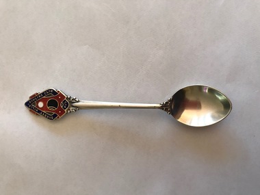
Souvenir - Souvenir teaspoon, Twentieth Century
... James Albon is credited with building the first bowling... Road Canterbury melbourne James Albon is credited with building ...James Albon is credited with building the first bowling green in Surrey Hills at his home on the corner of Mont Albert Road and Wilson Street (later occupied by the Roman Catholic convent). This green was so popular with his friends that he organised the formation of a bowling club at the corner of Montrose and Wilson Streets. It opened in 1912. Earliest club records date from 1916. The original club-house was rebuilt in 1922/23 using interlocking blocks as recommended by Walter Burley-Griffin. This was quite an innovative design at the time. In turn cream brick buildings replaced this building in the 1950s. The Surrey Hills Bowls Club disbanded in 1995. The donor believed that this spoon belong to her grandfather David Miller (Dave) Mair who lived at 20 Barton Street until his death in 1938. Dave was an extremely keen sportsman (particularly bowls and cricket). He started the Kangaroo Cricket Club and worked for the Melbourne Cricket Club. She initially sent the spoon to the Surrey Hills Bowling Club in 1996, not realising that it had closed the previous year. It was returned to her and over 20 years later was donated to this collection. This is part of a large donation of material relating to the Deakin, Mair and Young families, all with connections to the Surrey Hills and Mont Albert area. This augments other material relating to the history of the Surrey Hills Bowling Club that was saved by Jocelyn and Ken Hall after the club closed in 1995. The official records of the club were deposited with the State Library of Victoria, but prior to this some summary notes were made by the Halls. The material is evidence of one of the earliest sporting clubs established in the area.An EPNS metal teaspoon, consisting of a curved bowl with a decorative plaque at the top of the handle. On the front of this is an image of a lawn bowls ball and a jack within a scroll and linked with a band containing the words "SURREY HILLS BOWLING CLUB VIC". The plaque is inlaid in red, navy, white and black enamel. The makers name is impressed into the back of the handle.Rear: "Paramount" / "E.P.N.S."surrey hills bowling club, souvenir spoons, david miller mair, dave mair, laurie young, laurie newton -
 Kew Historical Society Inc
Plan, Melbourne & Metropolitan Board of Works : Borough of Kew : Detail Plan No.1568, 1905
... /public buildings, the first St Hilary’s Anglican Church... of construction materials used in buildings in the first decade ...The Melbourne and Metropolitan Board of Works (MMBW) plans were produced from the 1890s to the 1950s. They were crucial to the design and development of Melbourne's sewerage and drainage system. The plans, at a scale of 40 feet to 1 inch (1:480), provide a detailed historical record of Melbourne streetscapes and environmental features. Each plan covers one or two street blocks (roughly six streets), showing details of buildings, including garden layouts and ownership boundaries, and features such as laneways, drains, bridges, parks, municipal boundaries and other prominent landmarks as they existed at the time each plan was produced. (Source: State Library of Victoria)This plan forms part of a large group of MMBW plans and maps that was donated to the Society by the Mr Poulter, City Engineer of the City of Kew in 1989. Within this collection, thirty-five hand-coloured plans, backed with linen, are of statewide significance as they include annotations that provide details of construction materials used in buildings in the first decade of the 20th century as well as additional information about land ownership and usage. The copies in the Public Record Office Victoria and the State Library of Victoria are monochrome versions which do not denote building materials so that the maps in this collection are invaluable and unique tools for researchers and heritage consultants. A number of the plans are not held in the collection of the State Library of Victoria so they have the additional attribute of rarity.Original survey plan, issued by the MMBW to a contractor with responsibility for constructing sewers in the area identified on the plan within the Borough of Kew. The plan was at some stage hand-coloured, possibly by the contractor, but more likely by officers working in the Engineering Department of the Borough and later Town, then City of Kew. The hand-coloured sections of buildings on the plan were used to denote masonry or brick constructions (pink), weatherboard constructions (yellow), and public buildings (grey). Plan No.1568 covers the area bounded by Cotham Road, John Street, Sackville Street, and Edward Street. Alfred Street and Rowland Street are in shown in the middle of the plan. The two most notable buildings shown are ‘St Helliers’, the home of the Dumaresq family, and St Hilary’s Church and school. While the colours used to indicate St Hilary’s are grey as in other civic/public buildings, the first St Hilary’s Anglican Church was at this stage constructed in weatherboard. At the left of the plan, facing Sackville Street is a house named ‘Glencara’. The 1988 ‘Kew Conservation Study’ recorded that “The first documentary evidence of this house comes from Rate Books which record that in 1893 a Mrs Treadway was the owner of this building with an N.A.V. of £81? At that date the occupier of the house was Charles B. Kelly, a clerk, while by 1910 Kelly had become the owner of the property described in that year ‘as a six-roomed stone, brick and wood house with stables and outbuildings’”. Contrary to this description, the 1905 plan indicates that the house was entirely constructed of masonry.melbourne and metropolitan board of works, detail plans, mmbw 1568