Showing 308 items
matching gold discoverer
-
 Ballarat Clarendon College
Book, Mrs E Burrows, Tuppy; or, the autobiography of a donkey, 1868
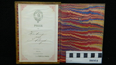
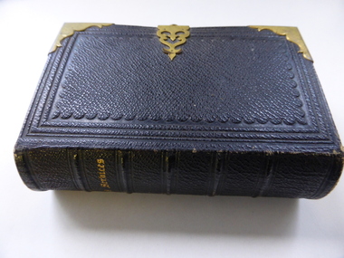
Book prize awarded to T Boyd (enrolled 1873) for excellence in Writing by Principal F J Thomas in 1874. The book was donated to the school by Sheila (Campbell) Edwards who purchased it from a secondhand dealer in Melbourne.During these early times book prizes were ordered from London where they were specially bound and embossed with the College crest. F J Thomas had an illustrious career at Ballarat College. During his tenure as Principal it was discovered the BA after his name stoold for Bonn Academy (Germany) not, as may have been implied, Bachelor of Arts. Once discovered he left the State under 'not too dignified circumstances' as Mein records in the 1964 History of Ballarat College, p. 19. Light brown calf binding with gold borders to front and back covers; raised bands on spine with six compartments, gold lettering and decoration; school crest embossed on front cover; book plate inside front cover;black and white sketches on frontispiece and throughout book;Book plate inside front cover: Ballarat College crest / PRIZE / FOR / Writing / Awarded to / T Boyd / 1874 / F J THOMAS, B.A.PRINCIPALshelia-edwards, thomas-boyd, 1974, book-prize, ballarat-college, f-j-thomas -
 Bendigo Military Museum
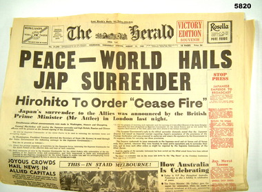
Newspaper - NEWSPAPER, 1945 Victory Edition Souvenir, The Herald, 1995
Jack KINGSBURY/ Born Northern W.A. 16 March 1916 Died 14 August 1983 Age 14 worked in gold mines at Kalgoorlie for som years then came to Bendigo/mines. He met and married Jessie PITTS in 1936. He enlisted in the airforce in 1941 and was studying to be a pilot when he retired. Cat No 5821,5822,5823 Leigh Joseph JONES/ Born Richmond 2 June 1922 to 18 March 1983. Married Dorothy Jean PITTS 18 March 1944. Applied to join the army but was too young. Returned to join as his fathers name Lewis John same initials and old enough. He served and was discharged as this name. He was aboard ship when it was discovered too late. He served in New Guinea. Post war he applied to have his service name corrected, he was a champion sports man, cycling, football, bowling. Awarded an imperial award for his work with Papua New Guinea “Newspaper- reprint of the The Herald original newspaper from MELBOURNE WEDNESDAY EVEING AUGUST 15, 1945 Black and white print and photographs on paper newspaper, military history, ww2 -
 Bendigo Military Museum
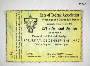
Administrative record - RATS OF TOBRUK ASSOCIATION, Rats of Tobruk Association, 1977, 1990
Items were discovered in the Rats of Tobruk case in the Bendigo Soldiers Memorial Military Museum. Compliments card was discovered inside the front cover of the Bendigo's Own Rats of Tobruk book in museum library. D.H Gray is identified as Douglas Haig Gray, VX45356, 2/24th Infantry Battalion who served in the Siege of Tobruk in 1941..1) Cardboard dinner invitation. Yellow coloured, black ink. It has the name and badge of the Rats of Tobruk Association. Decorative jagged edges, painted gold. .2) Cardboard cover booklet. Rats of Tobruk Association name and badge. 24 pages. Yellow cover. .3) Compliments card, white, gold printing with Rats of Tobruk Association badge and name..3) Compliments card has written in blue pen, “P121.2 150-1” and signed “D.H. Gray President”bylaws, compliments, rats of tobruk -
 Bendigo Military Museum
Book - BOOK WW1, WW2, The World at War, 2016
Discover the fascinating story behind the Great Wars. Discover all you need to know about WWI & WWII.Cover - soft cardboard. Red black & gold print on front, spine & back. Front cover background coloured battle scene with tank & soldier. Back cover background sepia colours of portrait photo of soldier in uniform & ammunition. 303 pages, cut plain white. Illustrated with black & white & coloured photos. End paper black & white photo of soldier on front, aircraft on back.books, military history, ww1. ww2 -
 Bendigo Military Museum
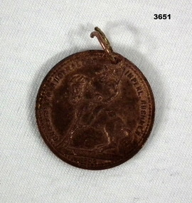
Memorabilia - MEDALLION, BOER WAR, c.1902 - 1905
Discovered in One Tree Hill Park, Bendigo whilst gold prospecting.Copper medallion etched with portrait of Queen Victoria on front, bushman on back. Front: “BRITISH TRANSVAL WAR 1899 - 1902” Back: “SUCCESS TO AUSTRALIAN IMPERIAL BUSHMEN 1902”medallion, memorabilia, boer war, bushmen -
 Bendigo Military Museum
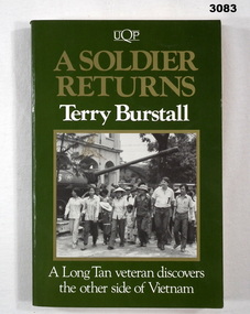
Book - BOOK, VIETNAM, Terry Burstall, A Soldier Returns, A Long Tan Veteran Discovers the Other Side of Vietnam, 1990
Terry Burstall records his search for answers to his battle at Long Tan during four visits to Vietnam. He compares official war records with first hand accounts of Vietnamese veterans, villagers & a former POW.Soft card cover. Title in gold & white print on a green background. Front cover illustrated with a black & white photo. 215 pages with cut edges. Illustrated with black & white photos. Map of South Vietnam opposite title page.books-travelogues, military history-army, long tan, vietnam -
 Federation University Historical Collection
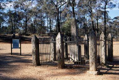
Slide, Welcome Stranger Monument, c1970
The first recorded discovery of gold in Moliagul was in September 1852 and, before long, the area was flooded with over 4,000 miners. Two of those miners, John Deason and Richard Oates, had arrived in Bendigo in 1954 seeking their fortune. After eight years of little success, the friends moved to Moliagul and pegged a puddling claim. On 05 February 1869, Deason discovered a nugget near the roots of a tree, just 3cm beneath the soil. With the help of Oates, he uncovered the largest recorded alluvial gold nugget – known as the Welcome Stranger. The 61cm x 31cm nugget was taken to Dunolly to be measured on the bank’s scales, however at 69kg the gold needed to be broken on an anvil to actually fit on the scales.Photograph of the monument for the Welcome Nugget, a large gold nugget found by John Deason and Richard Oates at Moliagul.Obelisk inscription Welcome Stranger Nugget On this spot the largest nugget of gold in the world was discovered on the 5th February 1869 by John Deason and Richard Oates. Weight 2316 oz, Value £9553 Erected by the Mines Department 1897 Henry Foster Minister of Mines, D. J. Duggan M.L.A. Member for Dunollywelcome nugget, welcome nugget monument, john deason, richard oates -
 Mission to Seafarers Victoria
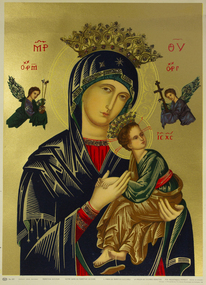
Print - Reproduction of a painting, Perpetual Succour
Discovered in the Chapel of St Peter when packing up for renovations. Probably a gift from an Eastern European crew member visiting the Mission TBC.Print of Eastern Orthodox style painting of Madonna and child on gold ground printed inscription lower edge of imageorthodox church, nativity, mary, jesus, crown, angel, artwork-paintings -
 Mission to Seafarers Victoria
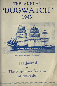
Journal (item) - Periodicals-Annual, Shiplovers' Society of Victoria, The Annual Dog Watch, 1943
This journal provides the reader with glimpses of the adventures and hardships of a seaman's life. Many of the stories are of sailing ships.First issue of the magazine published during the war Contributes to our knowledge of the importance of shipping and places on record those stories of the sea which would otherwise be lost.sailing ships, steamships, shipping, seafaring life, shiplovers' society of victoria, dog watch, ww2, hms jervis bay -
 Glenelg Shire Council Cultural Collection
Book, George Alfred Henty, Dorothy's Double, 1894
Dorothy Hawtrey's life is turned topsy turvy by a rogue enemy who cultivates a poor girl who resembles Dorothy and uses her to impersonate Dorothy. The tale expands to the California gold fields where the double and her captor are eventually discovered. The double turns out to be a long lost sister, the rogue is killed, and all ends well.Dark brown leather bound spine and cover corners. Green cloth-covered board covers. Gold text on spine.fictionDorothy Hawtrey's life is turned topsy turvy by a rogue enemy who cultivates a poor girl who resembles Dorothy and uses her to impersonate Dorothy. The tale expands to the California gold fields where the double and her captor are eventually discovered. The double turns out to be a long lost sister, the rogue is killed, and all ends well.fiction, historical fiction, thriller -
 Eltham District Historical Society Inc
Photograph, The Leader, The "Black Swan" Mine and "The Old Dam", Warrandyte Gold Fields, 1897
Reproduced from "The Leader" 14th Aug. 1897, page 7 The "Black Swan" mine - on Captain Selby's property of 200 acres. Discovered by Captain Selby 8 years ago. He is working it himself. 'The shaft is down 70 feet and with deeper sinking the reef is found to increase in width. Nearly £2,000 has been obtained from this mine, the gold being of high quality, fetching £4-1-6 per oz.' Warrandyte photo "The Old Dam" - erected accross the river by Mr John Wallace, M.L.C., who attempted to turn the river and to work the river bed.This photo forms part of a collection of photographs gathered by the Shire of Eltham for their centenary project book,"Pioneers and Painters: 100 years of the Shire of Eltham" by Alan Marshall (1971). The collection of over 500 images is held in partnership between Eltham District Historical Society and Yarra Plenty Regional Library (Eltham Library) and is now formally known as the 'The Shire of Eltham Pioneers Photograph Collection.' It is significant in being the first community sourced collection representing the places and people of the Shire's first one hundred years.Digital imagesepp, shire of eltham pioneers photograph collection, warrandyte, gold mining, black swan mine, old dam -
 Warrnambool and District Historical Society Inc.
Book, The book of common prayer
Unfortunately we do not know who donated this book to the Warrnambool & District Historical Society and so we do not know the identity of C.M.B or S.A.B. S.A. Burtt is listed as a Timor Street grocer in 1856 and as a Director of the Western District Fishing Company (1858-9). Was he the S.A.B. who gave the book to his sister in 1854? The fact that we have the book indicates that perhaps C.M.B. also came to settle in Victoria at a later date.This is a very attractive little prayer book and remains for us a fascinating relic of 19th century migration to Victoria. It will be even more valuable if we ever discover the identity of the giver and receiver of the book.This is a hard cover leather- bound book. The book contains a Contents page, a Preface and the Common Prayers of the Church of England together with the Psalms of David. The spine has gold lettering and the cover is edged and reinforced with gold-coloured metal and there is a gold ornamental metal clasp which is affixed with small nails to the front and back covers and which closes over the pages. The pages are gilt-edged. The inscription on the first page is handwritten in blue ink and there is a loose sheet which is a printed prayer for the Governor and the Council and another loose piece of blue ribbon used as a marker. The spine of the book is slightly rubbed. There are some indecipherable pencil markings on the back page. ‘To C. M. B. A farewell gift from a brother to his sister on his sailing for Victoria From S.A.B.1854’ 19th century migration to victoria history of warrnambool -
 Ringwood and District Historical Society
Booklet - Newsletter, Warrandyte Historical Society Inc. - Louis John Michel, Discoverer of the First Payable Gold Field in Victoria, 1979
Letter and article entitled "MICHEL" by Mrs. Evelyn J. Cooke - Article written by his great granddaughter, addressed to Mrs Jo Laurence of the Warrandyte Historical Society. -
 Ringwood and District Historical Society
Booklet - Newsletter, Warrandyte Historical Society Inc. - The First Gold Field in Victoria - How l discovered it, by Louis John Michel, 1896
Personal recollections of Louis John Michel after the events which he described in The Argus on Saturday 28 December 1895 -
 Flagstaff Hill Maritime Museum and Village
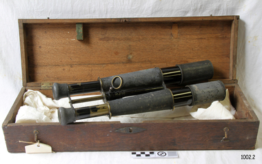
Instrument - Optical, Binoculars, 1878 (estimated)
This pair of brass binoculars was presented to Tom Pearce in recognition of his heroic efforts at the wrecking of the Loch Ard and saving Eva Carmichael. They were presented to him by the Lady Mayoress of Sydney on 27th July 1878 on behalf of the colonists of New South Wales "In recognition of his gallant conduct on the occasion of the wreck of the Loch Ard". Tom (Thomas) Pearce was born in Ireland in 1859 and arrived in Melbourne two years later; he considered himself as Australian. Before sailing on the Loch Ard he had been at sea for three years as an apprentice sailor and had already experienced one shipwreck. Tom was on the deck of the Loch Ard with Captain Gibb throughout the night of May 31st 1878. It was mistakenly thought they were 150 miles (240 km) southwest of Cape Otway. By 2:00 am on June 1st, the wind was blowing "pretty fresh" but a thick haze remained and, when it eventually cleared, the land was so close the unsuccessful battle to save the Loch Ard began. After the ship struck Mutton Bird Island Tom and five others were sent to the lifeboats. Conditions were very dangerous as waves broke over the decks and they were all washed away. Tom found himself in the stormy waters and under a lifeboat, which had also been washed into the sea. After being swept into the gorge Tom left the boat and swam into shore; he was alone. Eva Carmichael, a passenger on the ship, had been snatched from her bed just before dawn and into the chaos, confusion and terror of the shipwreck, with rigging and rocks raining down. Thrown into the sea, she afterwards said: "God taught me to swim in my distressful plight, for I never swam before". Clinging to a spar, she was swept into the gorge and saw Tom Pearce walking along the beach. Upon hearing the cries of Eva, Tom swam out and with great difficulty brought her to the shore and placed her safely in a cave where he made a bed of grass and shrubs and gave her brandy to revive her. She sank into exhausted unconsciousness. Tom then scrambled to the top of the high cliff and after walking for some time he stumbled upon workers from Glenample Homestead. They rode back to the homestead for help but Tom insisted on returning to Eva. When Eva awoke she found herself alone, "cold, weak and terrified with the wild waves before me, and caves and cliffs around me" and upon hearing strange noises, which she imagined to be made by the local indigenous people, she hid. The noises were made by the rescue party from Glenample Homestead. After eventually discovering Eva they hauled her up the cliff in the darkness of night, “a work of great difficulty and danger” and took her to Glenample. Sadly, Tom and Eva were the only survivors of the 54 people on board the Loch Ard. Tom’s rewards for his bravery included the Gold Medal of the Humane Society, a gold watch and £1000 from the Victorian Government, a set of nautical instruments, (which included the binoculars) from the people of Sydney and £60 from the people of Warrnambool. He was also presented with a Bible by a “Friend of the Loyal Orange Institution of Victoria, Protestant Hall Melbourne” in August 1878. Coleman Jacobs composed the music "The Young Hero Schottische" and dedicated it, by permission, to Mr Thomas R. (Tom) Pearce. The sheet music was published in 1878 by Mr Roberts, professor of dancing and was on sale for 3/- (3 shillings) in aid of the "Loch Ard" fund. Tom Pearce went on to join the Loch Sunart on her return to England, only to be wrecked again off the Irish coast in January 1879. Tom left the Loch Line in 1883 and the following year married Edith Gurney Strasenbergh, the sister of his friend Robert who had died on the Loch Ard. They had three children, unfortunately, two of the male children were to die at sea. In 1895 Tom obtained his first command as Master of The Larne, a vessel with the Royal Mail Steam Packet Company. He remained with the company until he died in Southampton, England, on 14th December 1908. Tom Pearce never saw Eva Carmichael after he had fare welled her some 30 years before. Eveline Victoria Berta Carmichael was born in 1859 in Mountrath, Queens County, Ireland. After recovering from her ordeal in August 1878 Eva returned to Ireland and in 1884 married Thomas Achilles Townshend, a Civil Engineer. They had three sons, all of whom had successful military careers, and when Eva’s death notice appeared in the Melbourne Argus It read. "Townshend on 8th April 1934 aged 74 at her residence in Bedford, England, Evaline Victoria, widow of the late Thomas Archilles Townshend, C.E. of Co. Cork, Ireland. Mrs Townshend was the Eva Carmichael who, with the late Tom Pearce, were the only two survivors of the ship Loch Ard, which was wrecked near Port Campbell on June 1st 1878." The binoculars are significant for their association with the wreck of the Loch Ard and the only two surviving members of that wreck Tom Pearce and Eva Carmichael. Flagstaff Hill’s collection of artefacts from Loch Ard is significant for being one of the largest. The shipwreck of the Loch Ard is of significance for Victoria and is registered on the Victorian Heritage Register ( S 417). Flagstaff Hill has a varied collection of artefacts from Loch Ard and its collection is significant for being one of the largest accumulation of artefacts from this notable Victorian shipwreck. The collections object is to also give us a snapshot into history so we can interpret the story of this tragic event. The collection is also archaeologically significant as it represents aspects of Victoria's shipping history that allows us to interpret Victoria's social and historical themes of the time. The assemblage of items from the wreck is of historical significance in that they are associated with the worst and best-known shipwreck in Victoria's history. Pair of brass marine binoculars in a wooden box On the left hand eye piece, on the underside, is an engraved inscription and another engraved word. On the right hand eye piece there is another small inscription and on the underside there is a small green mark. The binoculars have a pattern of embossed tiny circles on the outside. Some of the patterning is very shiny due to wear and rubbing, there is a brass ring on the underside of the binoculars for the attachment of a lanyard. The wooden box has a hinged lid and on the front of the box in the centre is a lock, and at either end are two hooks and eyes. The box is split across the top for about 3/4 of the length. Marking on the left underside reads, 'Presented on behalf of the Colonists of New South Wales By the Mayoress of Sydney on 27th. July 1878 to Mr Thomas B Pearce. In recognition of his gallant conduct on the occasion of the wreck of the "Loch Ard"'. Underneath this inscription is engraved 'Sydney'. On the other eye piece is engraved what looks like 'Mac Donnell & Co' binoculars, flagstaff hill, warrnambool, shipwrecked coast, flagstaff hill maritime museum, maritime museum, shipwreck coast, flagstaff hill maritime village, loch ard shipwreck, tom pearce, thomas r pearce, eva carmichael, mutton bird island, loch ard survivor, loch ard hero, coleman jacobs, the young hero schottische, photograph of tom pearce, glenample homestead -
 Flagstaff Hill Maritime Museum and Village
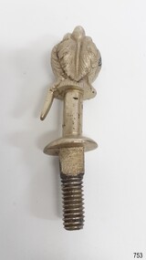
Decorative object - Buggy Fitting, Circa 1855
This ornate fitting for a horse-drawn vehicle was amongst the items recovered from the Schomberg over one hundred years after it was wrecked. ABOUT THE SCHOMBERG (October 6 to December 27, 1855)- When the ship Schomberg was launched in 1855, she was considered the most perfect clipper ship ever to be built. James Baine’s Black Ball Line had commissioned her for their fleet of passenger liners. The Aberdeen builders designed her to sail faster than the clippers designed the three-masted wooden clipper ship to be fast. The timber used for the diagonal planking was British oak with layers of Scottish larch. This luxury emigrant vessel was designed for superior comfort. She had ventilation ducts to provide air to the lower decks and a dining saloon, smoking room, library and bathrooms for the first-class passengers. The master for Schomberg’s maiden voyage was Captain ‘Bully’ Forbes. He drunkenly predicted at her launch that he would make the journey between Liverpool and Melbourne in 60 days. Schomberg departed Liverpool on 6 October 1855 with 430 passengers and 3000 tons of cargo including iron rails and equipment intended the build the Geelong Railway and a bridge over the Yarra from Melbourne to Hawthorn. The poor winds slowed Schomberg’s sail across the equator. She was 78 days out of Liverpool when she ran aground on a sand spit near Peterborough, Victoria, on 27 December; the sand spit and currents were not marked on Forbes’s map. The ship’s Chief Officer spotted the coastal steamer SS Queen at dawn and sent a signal. The master of the SS Queen approached the stranded vessel and all of Schomberg’s passengers safely disembarked. In 1975, 120 years after the Schomberg was wrecked, divers from Flagstaff Hill found an ornate communion set at the wreck site along with many other artefacts. In 1978 a diamond ring was discovered under the concretion in the lid of the communion set, which is currently on display. Former Director of Flagstaff Hill, Peter Ronald, had salvaged most of the artefacts from the wreck. The Schomberg has historical significance as one of the first luxurious ships built to bring emigrants to Australia to cash in on the gold rush era. And is included on the Victorian Heritage Register (VHR S612). The collection of Schomberg artefacts held at Flagstaff Hill Museum is primarily significant because of the relationship between these recovered items having a high potential to interpret the story of the Schomberg and its foundering during a storm. The shipwreck is of additional historically significance for representing aspects of Victoria’s shipping history and for its association with the first passenger ship, which was designed not only to be the fastest and most luxurious of its day but foundered on its maiden voyage to Australia.Ornate buggy or coach fitting with feather plumes on top, and a screw thread on the bottom. Silver plated,.warrnambool, flagstaff-hill, flagstaff-hill-maritime-museum, shipwreck-coast, flagstaff-hill-maritime-village, schomberg, shipwrecked-artefact, clipper ship, black ball line, 1855 shipwreck, aberdeen clipper ship, captain forbes, peterborough shipwreck, ss queen, artifact, ornate fitting, buggy fitting -
 Flagstaff Hill Maritime Museum and Village
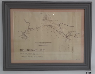
Document - Location Chart, The Mahogany Ship, 2007
This chart shows a possible site for the fabled wreck called the 'Mahogany Ship'. Flagstaff Hill’s collection includes other objects that some say could be relics from this Ancient Wreck, (also called the Gold Ship, or the Ancient Vessel). The chart shows the coordinates for the Summits of Griffith Island and of Middle Island. It also has the depths of the sea at various intervals and shows the shore and sand dunes, lighthouses and other reference points. The mystery of the Mahogany Ship began in 1836 when two shipwrecked sealers discovered the remains of an “ancient vessel” in the sand dunes about four miles west of Warrnambool. Since the last recorded sightings in the 1880’s the true origin of the Mahogany Ship has remained one of Australia’s most famous historical mysteries or fables. One of the more recent theories is that the vessel was one of the Portuguese ships exploring the Australian coast in 1522. For over one hundred years searchers have attempted to locate and identify the wreck. The search continues for the tangible evidence which will once and for all establish the Mahogany Ship’s place in Australia’s History.The chart represents the worldwide interest in locating the wreck of the Mahogany Ship. Locating the actual wreck or proving the existence of a Portuguese ship's wreck could change the history of the discovery of Australia. A Mahogany Ship committee was formed to gather and research information about the discovery of the wrecked ship. A large amount of money was offered as a prize for finding the wreck or parts of it. People have written books, painted images, made videos and told tales of the ship but it continues to remain a mystery or even a fable. The chart is significant for its possible link to one of Victoria’s and Australia’s maritime mysteries, the Mahogany Ship (also known as the Ancient Wreck). It is one of very few known relics that could give evidence of the existence and history of the vessel. It is listed on the Victorian Heritage Register S438 as it is one of Victoria’s oldest recorded shipwrecks. The identity of the vessel has the potential to change Australia’s history.A chart in a wooden frame, behind glass. The chart shows the approximate position of the mystery Ancient Wreck, later called the "Mahogany Ship". The chart is a copy and is based on the Admiralty Chart by Lieut. Stanley, dated 1872. Lower left: "THE MAHOGANY SHIP" "LOCALITY PLAN, ENLARGED FROM LIEUT. STANLEY'S ADMIRALTY CHART 1872" "APPROXIMATE POSITION OF WRECK MARKED [symbol of a Portuguese cross]" Other labels on chart: "BELFAST" "PORT FIARY" "GRIFFITHS I" "RIVER MOYNE" "RIVER MERRI" "ARMSTRONG BAY" " GORMANS LANE" "TOWER HILL" "KOROIT" "HELEN ROCK" "WARRNAMBOOL" "LADY BAY" "MIDDLE I" "LIGHT HO." Lower right: "G 410 B" Label on the back; "This chart presented to the Mahogany Ship Committee and Flagstaff Hill by Avis Quarrell, April 2007"warrnambool, shipwrecked coast, flagstaff hill maritime museum, shipwreck coast, mahogany ship, ancient vessel, ancient wreck, portuguese ship, coastal reserve, fabled wreck, gold ship, griffiths island, belfast (now port fairy), koroit, location plan, leuit. stanley, admiralty chart 1872, tower hill, merri river, moyne river, middle island, helen rock, armstrong bay, griffiths land -
Marysville & District Historical Society
Document (item) - Gold Mine Prospectus, H.D. McKie, Prospectus of the New Golden Bower & Star Gold M.Co, 1896
... of the Prospectus of the New Golden Bower & Star Gold M.Co. near Marysville ...A copy of the Prospectus of the New Golden Bower & Star Gold M.Co. near Marysville in Victoria.A copy of the Prospectus of the New Golden Bower & Star Gold M.Co. near Marysville in Victoria. The Golden Bower gold mine was a quartz reef mine. William Edward Chester discovered the Golden Secret gold vein which became part of the Golden Bower Mine at Chesterville near Donovans Creek on the Cumberland goldfield which he mined with George Locke until the late 1930s. new golden bower & star gold m.co., donovan's creek, nuggety gully creek, yarra track, marysville, victoria, share prospectus, upper yarra track, wood's point, victoria mount morgan gold mining co., british mount morgan mine, mr white, reefton turnoff, santa claus reef, bear's creek, mr r ely, bear's creek reef, big river, mr feely, new star reef, golden bower reef, a1 mining co, mr r m lee, locke's no.1 extended gold mining company, mr q dick -
Marysville & District Historical Society
Document (item) - Gold Mine Prospectus, Messrs Bruce & Robinson, Prospectus-Chester & Locke's Golden Secret Gold Mining Company, 1899
... . William Edward Chester discovered the Golden Secret gold vein ...A copy of the prospectus for the Chester & Locke's Golden Secret Mining Company near Marysville in Victoria.A copy of the prospectus for the Chester & Locke's Golden Secret Mining Company near Marysville in Victoria. The Golden Bower gold mine was a quartz reef mine. William Edward Chester discovered the Golden Secret gold vein which became part of the Golden Bower Mine at Chesterville near Donovans Creek on the Cumberland goldfield which he mined with George Locke until the late 1930s. FOR PRIVATE CIRCULATIONshare prospectus, chester & locke's golden secret mining company, marysville, victoria, yarra track, upper yarra district, david newell, j.g. aikman, w.j. mountain, andrew barrie, gold mining, messrs w.p. jones and co., william chester, george locke, chesterville -
Marysville & District Historical Society
Document (item) - Historic Site Register Sheet, Parks Victoria, Historic Site Recording System-Site Register Sheet-Chester & Locke Mine, 1989
... Chester discovered the Golden Secret gold vein which became part ...A copy of a historic site register sheet for the Chester and Locke gold mine near Marysville in Victoria.A copy of a historic site register sheet for the Chester and Locke gold mine near Marysville in Victoria. The Golden Bower gold mine was a quartz reef mine. William Edward Chester discovered the Golden Secret gold vein which became part of the Golden Bower Mine at Chesterville near Donovans Creek on the Cumberland goldfield which he mined with George Locke until the late 1930s. chester and locke mine, william chester, george locke, cambarville, yarra ranges, walker's hotel, marysville, victoria -
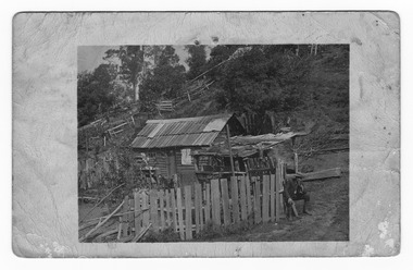
 Marysville & District Historical Society
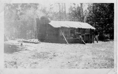
Photograph (item) - Black and white photograph, Unknown
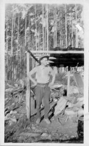
An early black and white photograph of George Locke's hut in the Cumberland Valley near Marysville in Victoria.An early black and white photograph of George Locke's hut in the Cumberland Valley near Marysville in Victoria. George Locke was a well-educated young man and had some success prospecting in the Cumberland area before partnering with William Chester with whom he opened the Golden Bower gold mine in 1896. George and William then discovered a second reef which they named the Silver Bower mine. George lived in a log cabin in the Cumberland reserve and was known to be a loner. He was clever with his money and chose not to have a bank account in Marysville, where everyone would learn about his financial status. He banked at the ES&A in Fitzroy and at the time of his death in 1941 he had accumulated the princely sum of three hundred and sixty pounds. George Locke was known as "the Hermit of Cumberland Valley" and lived in his humpy until his last few days during which he moved into a Forest Commission's patrol hut because his old humpy had started to fall to pieces. When George passed away at the age of 81 years he had not visited Marysville for over 14 years. Today (2022) George Locke's hut is part of the Cumberland Reserve.Mr Lock hermit Joy Marysville 392george locke, cumberland valley, marysville, victoria, william chester, golden bower mine, silver bower mine, cumberland reserve, hermit of cumberland valley -
 Marysville & District Historical Society
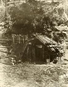
Photograph (item) - Black and white photograph, Unknown
An early black and white photograph of George Locke's hut in the Cumberland Valley near Marysville in Victoria.An early black and white photograph of George Locke's hut in the Cumberland Valley near Marysville in Victoria. George Locke was a well-educated young man and had some success prospecting in the Cumberland area before partnering with William Chester with whom he opened the Golden Bower gold mine in 1896. George and William then discovered a second reef which they named the Silver Bower mine. George lived in a log cabin in the Cumberland reserve and was known to be a loner. He was clever with his money and chose not to have a bank account in Marysville, where everyone would learn about his financial status. He banked at the ES&A in Fitzroy and at the time of his death in 1941 he had accumulated the princely sum of three hundred and sixty pounds. George Locke was known as "the Hermit of Cumberland Valley" and lived in his humpy until his last few days during which he moved into a Forest Commission's patrol hut because his old humpy had started to fall to pieces. When George passed away at the age of 81 years he had not visited Marysville for over 14 years. Today (2022) George Locke's hut is part of the Cumberland Reserve.george locke, cumberland valley, marysville, victoria, william chester, golden bower mine, silver bower mine, cumberland reserve, hermit of cumberland valley -
 Marysville & District Historical Society
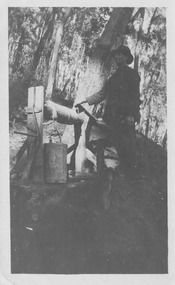
Photograph (item) - Black and white photograph, Unknown
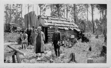
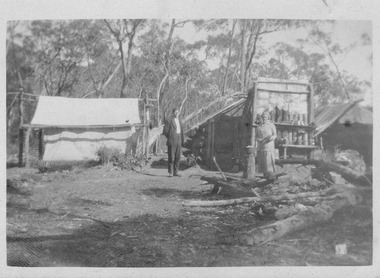
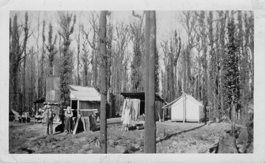
... Chester discovered the Golden Secret gold vein which became part ...An early black and white photograph taken at the Golden Bower in the Cumberland Valley in Victoria.An early black and white photograph taken at the Golden Bower Mine in the Cumberland Valley in Victoria. The Golden Bower gold mine was a quartz reef mine. William Edward Chester discovered the Golden Secret gold vein which became part of the Golden Bower Mine at Chesterville near Donovans Creek on the Cumberland goldfield which he mined with George Locke until the late 1930s. golden bower gold mine, cumberland valley, victoria, quartz reef mining, water-powered battery, william edward chester, george locke, chesterville, donovan's creek, cumberland goldfield -
 Marysville & District Historical Society
Photograph (item) - Black and white photograph, Unknown
... in the Cumberland Valley in Victoria. The Golden Bower gold mine ...An early black and white photograph of the blacksmith's forge at the Golden Bower mine in the Cumberland Valley in Victoria.An early black and white photograph taken at the Golden Bower Mine in the Cumberland Valley in Victoria. The Golden Bower gold mine was a quartz reef mine. William Edward Chester discovered the Golden Secret gold vein which became part of the Golden Bower Mine at Chesterville near Donovans Creek on the Cumberland goldfield which he mined with George Locke until the late 1930s. golden bower gold mine, cumberland valley, victoria, quartz reef mining, water-powered battery, william edward chester, george locke, chesterville, donovan's creek, cumberland goldfield -
 Marysville & District Historical Society
Photograph (item) - Black and white photograph, Unknown
... Chester discovered the Golden Secret gold vein which became part ...An early black and white photograph of the Golden Bower mine in the Cumberland Valley in Victoria.An early black and white photograph taken at the Golden Bower Mine in the Cumberland Valley in Victoria. The Golden Bower gold mine was a quartz reef mine. William Edward Chester discovered the Golden Secret gold vein which became part of the Golden Bower Mine at Chesterville near Donovans Creek on the Cumberland goldfield which he mined with George Locke until the late 1930s. golden bower gold mine, cumberland valley, victoria, quartz reef mining, water-powered battery, william edward chester, george locke, chesterville, donovan's creek, cumberland goldfield -
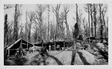
 Marysville & District Historical Society
Photograph (item) - Black and white photograph, Unknown
... Chester discovered the Golden Secret gold vein which became part ...An early black and white photograph of the Golden Bower mine camp in the Cumberland Valley in Victoria.An early black and white photograph taken at the Golden Bower Mine in the Cumberland Valley in Victoria. The Golden Bower gold mine was a quartz reef mine. William Edward Chester discovered the Golden Secret gold vein which became part of the Golden Bower Mine at Chesterville near Donovans Creek on the Cumberland goldfield which he mined with George Locke until the late 1930s. golden bower gold mine, cumberland valley, victoria, quartz reef mining, water-powered battery, william edward chester, george locke, chesterville, donovan's creek, cumberland goldfield -
 Marysville & District Historical Society
Photograph (item) - Black and white photograph, Unknown
... . William Edward Chester discovered the Golden Secret gold vein ...An early black and white photograph taken at the Golden Bower Mine Camp in the Cumberland Valley in Victoria.An early black and white photograph taken at the Golden Bower Mine in the Cumberland Valley in Victoria. The Golden Bower gold mine was a quartz reef mine. William Edward Chester discovered the Golden Secret gold vein which became part of the Golden Bower Mine at Chesterville near Donovans Creek on the Cumberland goldfield which he mined with George Locke until the late 1930s. golden bower gold mine, cumberland valley, victoria, quartz reef mining, water-powered battery, william edward chester, george locke, chesterville, donovan's creek, cumberland goldfield -
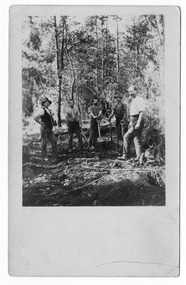
 Marysville & District Historical Society
Photograph (item) - Black and white photograph, Unknown
... . William Edward Chester discovered the Golden Secret gold vein ...An early black and white photograph taken at the Golden Bower Mine in the Cumberland Valley in Victoria.An early black and white photograph taken at the Golden Bower Mine in the Cumberland Valley in Victoria. The Golden Bower gold mine was a quartz reef mine. William Edward Chester discovered the Golden Secret gold vein which became part of the Golden Bower Mine at Chesterville near Donovans Creek on the Cumberland goldfield which he mined with George Locke until the late 1930s. golden bower gold mine, cumberland valley, victoria, quartz reef mining, water-powered battery, william edward chester, george locke, chesterville, donovan's creek, cumberland goldfield -
 Marysville & District Historical Society
Postcard (item) - Black and white postcard, Unknown
... . William Edward Chester discovered the Golden Secret gold vein ...An early black and white photograph taken at the Golden Bower Mine in the Cumberland Valley in Victoria.An early black and white photograph taken at the Golden Bower Mine in the Cumberland Valley in Victoria. The Golden Bower gold mine was a quartz reef mine. William Edward Chester discovered the Golden Secret gold vein which became part of the Golden Bower Mine at Chesterville near Donovans Creek on the Cumberland goldfield which he mined with George Locke until the late 1930s. POST CARD EMPIRE FOR CORRESPONDENCE FOR ADDRESS ONLY STAMPgolden bower gold mine, cumberland valley, victoria, quartz reef mining, water-powered battery, william edward chester, george locke, chesterville, donovan's creek, cumberland goldfield, postcard, souvenir -
 Marysville & District Historical Society
Postcard (item) - Black and white postcard, Unknown
... . William Edward Chester discovered the Golden Secret gold vein ...An early black and white photograph taken at the Golden Bower Mine Camp in the Cumberland Valley in Victoria.An early black and white photograph taken at the Golden Bower Mine Camp in the Cumberland Valley in Victoria. The Golden Bower gold mine was a quartz reef mine. William Edward Chester discovered the Golden Secret gold vein which became part of the Golden Bower Mine at Chesterville near Donovans Creek on the Cumberland goldfield which he mined with George Locke until the late 1930s. POST CARD CORRESPONDENCE. ADDRESS ONLY. KODAK/ AUSTRALIA 30/06/10 Rose Hill/ Fitzwilliam Street/ Kew Should have written/ to you months ago about the/ photos I took at Easter./ Sorry to say the one of the little/ girls was no good I expect/ you will recognise both these/ places/ K McDowell Mrs Fletcher/ Golden Bower Mine/ Via Marysville J Mahoneygolden bower gold mine, cumberland valley, victoria, quartz reef mining, water-powered battery, william edward chester, george locke, chesterville, donovan's creek, cumberland goldfield