Showing 255 items
matching gold mining site
-
 Bendigo Historical Society Inc.
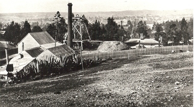
Photograph - MINE SITE
BHS CollectionBlack and white photograph of the Hustler's Mine as a part of the Bendigo mining landscape with the valley in the background. On the left hand side is the poppet head, chimney and mining sheds and in the foreground is the bare stony earth.bendigo, mining, hustler's royal reserve mine, bendigo, mines and mining, mines, mining, gold mining, gold, gold mines, place, bendigo mines -
 Bendigo Historical Society Inc.
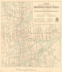
Map - DEPARTMENT OF MINES VICTORIA : PLAN SHOWING PORTION OF THE BENDIGO GOLD FIELD
Department of Mines Victoria. Plan showing portion of the Bendigo Gold Field. On the back is written, in ink, J. J. Tyler 1937 Northern Area. (He was a teacher at Bendigo High - see donation notes). Across the bottom of the map is written ' M. Hill cr. Myrtle & Barnard' .The named reef lines have been numbered with ink across the bottom of the map. The gullies have been coloured with green pencil and a red pencil line is drawn through the western side of the map. Additional information: anticlinal axial lines at surface, alluvial workings, shaft sites, area of Main Goldfield, Deepest mine workings, Gold output of field to 1935, and Dividends paid 1870 - 1935.bendigo, gold mining, bendigo gold field. gold mining. tyler, j. j. -
 Eltham District Historical Society Inc
Photograph - Digital Photograph, Marguerite Marshall, One Tree Hill Mine, Smiths Gully, 8 June 2006
Gold was discovered on One Tree Hill in 1854. The site has been worked intermittently until fairly recent times. Published: Nillumbik Now and Then / Marguerite Marshall 2008; photographs Alan King with Marguerite Marshall.; p53 Though still a working mine, One Tree Hill Mine at Smiths Gully, now stands in a tranquil reserve surrounded by bush and native animals - in contrast to its heyday. In the mid 19th century, when the mine was part of the Caledonia Goldfields, hundreds of men in search of their fortune worked the alluvial gold in the Yarra River, its tributaries and the reefs that made up the goldfields. Miner Stan Bone, assisted by Wilfred Haywood, is the last of the independent gold miners in the area and still uses the quartz crushing battery as miners did when gold was first discovered in the area in 1851.1 Stan, who is the last of six generations of miners in his family, was aged 17 when he began mining on his father Alex’ mine, The Golden Crown in Yarrambat. These days, after blasting the gold-bearing rock in Mystery Reef, one of the four reefs at One Tree Hill, Stan transports it around five kilometres by tip truck to the Black Cameron Mine for crushing. There he uses water from the waterlogged mine, (which still contains gold), as the Happy Valley Creek at One Tree Hill is usually dry.2 The One Tree Hill Mine has been worked for close to a century since it opened around the late 1850s.3 The Swedish Reef was its most productive reef and one of the largest in the area. Around 1859, extractions included 204 ounces (5.8kg) of gold, won from 57 pounds (26kg) of stone.4 Then during World War Two, Stan’s uncle, Bill Wallace, and Alex Bone, closed the mine. In 1973, Stan, with his Uncle Bill, reopened the Black Cameron Mine and worked there until 1988. Stan resumed mining One Tree Hill in 1998. As late as the 1920s gold was picked up by chance! When crossing a gully on his way to vote at the St Andrews Primary School, Bill Joyce picked up some quartz containing gold. This site was to become the Black Cameron Mine. The Caledonia Diggings, named after Scotland’s ancient name by local Scots, began around Market Square (now Smiths Gully) and included Queenstown (St Andrews), Kingstown (Panton Hill) and Diamond Creek. There were also poorer bearing fields in Kangaroo Ground and Swipers Gully (now Research). * None of these compared in riches to the Ballarat and Bendigo fields5, but the Caledonia Diggings continued intermittently for close to 100 years. Gold was discovered in Victoria following a bid to stem the disappearance of much needed workmen to the New South Wales diggings. Several businessmen offered a reward of £200, for the discovery of gold within 200 miles (322 km) of Melbourne. Late in June 1851, gold was first discovered at Andersons Creek, Warrandyte. Then in 1854, George Boston and two other men discovered gold at Smiths Gully. Gold transformed the quiet districts, with a constant flow of families and vehicles on the dirt tracks en route to the Caledonia Diggings. Three thousand people worked the gullies in Market Square, including about 1000 Chinese miners. The square established its own police, mining warden, gold battery, school, shops and cemetery and grog flowed. Market Square flourished until the middle 1860s. Bullocks transported quartz from the Caledonia Goldfields to the crushing machinery at the Queenstown/St Andrews Battery, near Smiths Gully Cemetery. It was destroyed by bushfire in 1962. By the late 1850s, most early alluvial fields were in decline, but minor rushes continued until around 1900 and some until the early 1940s. Some miners did well, although most earned little from their hard labour in the harsh and primitive conditions.6 But according to historian, Mick Woiwod, the gold fields helped to democratise society, as individuals from all walks of life were forced to share experiences, and the ability to succeed, depended less on inherited wealth or social rank.This collection of almost 130 photos about places and people within the Shire of Nillumbik, an urban and rural municipality in Melbourne's north, contributes to an understanding of the history of the Shire. Published in 2008 immediately prior to the Black Saturday bushfires of February 7, 2009, it documents sites that were impacted, and in some cases destroyed by the fires. It includes photographs taken especially for the publication, creating a unique time capsule representing the Shire in the early 21st century. It remains the most recent comprehenesive publication devoted to the Shire's history connecting local residents to the past. nillumbik now and then (marshall-king) collection, gold mining, one tree hill mine, smiths gully -
 Eltham District Historical Society Inc
Photograph - Digital Photograph, Alan King, Site of the Diamond Creek Gold Mine, 28 December 2007
The largest gold mine in the area originated from a find in 1862. The mine was closed January 20, 1915 when a fire destroyed nearly all the above ground plant. Published: Nillumbik Now and Then / Marguerite Marshall 2008; photographs Alan King with Marguerite Marshall.; p75 Beneath Mine Hill, as locals call it, runs a network of tunnels once of central importance to the fledgling township of Diamond Creek. These are relics of gold mines, which transformed early Diamond Creek.1 The tiny settlement of about 20 families soared to more than 200 because of gold. For around 50 years, from 1862, gold mining was Diamond Creek’s major source of employment. On September 7, 1854 The Argus newspaper reported a find of a four pound (1.8kg) gold nugget in Nillumbik (an early name for Diamond Creek). Exactly where, is not known.2 The largest mine in the district, the Diamond Creek Gold Mine, apparently originated from a find in 1862. It is said Joe and Dave Wilson were visiting former tailor then cook, Charles Orme, at the southern end of Fraser Street. Sitting on a stump outside the front gate on land belonging to Dr A. E. Phipps the Wilsons found a vein of gold-bearing quartz, which led to the discovery of four quartz reefs varying in width to eight inches (20cm), running north and south. A reef found at the foot of the hill opposite Challenger Street became the Union Mine. This reef was traced south to Allendale Road where a small mine began operations.3 Other smaller mines later operated as well. Dr Phipps immediately began to mine and also built the Diamond Reef Hotel as a boarding house for miners. But Charles Orme, who owned the land alongside, leased his mine to Dr Phipps probably because of insufficient funds and business skills. By mid 1865 the mine had produced 2530 ounces of gold – a 100% profit on the original outlay. Of course there were problems. When the local dam dried up a Blake pump was installed to draw water from the creek. The Union Mine operated under the Diamond Creek Gold Mine management except when disputes sometimes resulted in separate management. However disagreements had to be resolved as the Union Mine depended on Diamond Creek Gold Mine pumps to remove underground water from common reefs. In 1912 the main shaft of about 380 yards (350m) employed 200 men recovering an average of 5000 ounces (141.7kg) of gold a year. But not everyone did well out of gold. Records of failed mining companies in the Victorian Public Record Office, reveal that owner Dr Phipps leased his Right to others. Companies came and went over the next 40 years, most sponsored by Melbourne businessmen who sold shares to gullible locals and then became insolvent. Although there were some good profits, financial returns were haphazard until 1905. Some local residents, who were share holders in short- term companies, became well-known names in modern Diamond Creek such as Scott, Haley, Butler, Alder, Ryan, Wadeson, Reeves, Alston, Paul and Edwards. Gold mining was brought to a disastrous end on January 20, 1915 at 3 pm, when fire destroyed nearly all the above-ground plant. Fortunately no lives were lost. But reopening the mine was almost impossible because of the increasing depth of water in the main shaft. The closed mine destroyed the livelihood of 200 families and the debris took many years to clear.4 In 1946 the Diamond Creek Gold Mine was reopened by the Golden Hind Mining Company, but money ran out before the 600 feet (182.8m) or so of water could be removed. Gold remains in the mine but enormous capital would be needed to buy the land, equipment and to remove the water. Today 12 known sealed shafts along the ridge of the hills on private property extend west for around one kilometre from the corner of Fraser and Haley Streets, crossing Norma and Fyffe to Dering Streets. As recently as 1987, heavy rains revealed a former Union Mine shaft in the Georgiadis family Fyffe Street back yard.5 Allendale Mine, south of Allendale Road, is still open and one of the Union Mine’s main drives (horizontal excavation) remains unsealed, on the Creek Reserve.This collection of almost 130 photos about places and people within the Shire of Nillumbik, an urban and rural municipality in Melbourne's north, contributes to an understanding of the history of the Shire. Published in 2008 immediately prior to the Black Saturday bushfires of February 7, 2009, it documents sites that were impacted, and in some cases destroyed by the fires. It includes photographs taken especially for the publication, creating a unique time capsule representing the Shire in the early 21st century. It remains the most recent comprehenesive publication devoted to the Shire's history connecting local residents to the past. nillumbik now and then (marshall-king) collection, diamond creek, diamond creek mine, fraser street, gold mining, james cook drive, mine hill -
 Eltham District Historical Society Inc
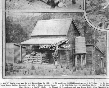
Photograph, Queenstown - St. Andrews District. "Quartz awaiting crushing at the State Battery in Smith's Gully.", c.1929
"The State Battery was the central component in the gold mining of this area from the 1920s. The battery crushed the gold bearing quartz extracted from the mines and was a sizeable weatherboard building enclosing the engine and stampers. All that now remains are the bases for the machinery that comprised the battery, one timber and a couple of concrete bases and the nearby dam, which supplied water. However the historic significance of the site remains and is enhanced by the Queenstown Cemetery on the other side of Smiths Gully Road". - Bick Study 1922 This site is now the Peter Franke Reserve and is managed by Parks Victoria Photo Source: The Leader, Nov. 2nd, 1929This photo forms part of a collection of photographs gathered by the Shire of Eltham for their centenary project book,"Pioneers and Painters: 100 years of the Shire of Eltham" by Alan Marshall (1971). The collection of over 500 images is held in partnership between Eltham District Historical Society and Yarra Plenty Regional Library (Eltham Library) and is now formally known as the 'The Shire of Eltham Pioneers Photograph Collection.' It is significant in being the first community sourced collection representing the places and people of the Shire's first one hundred years.Digital imagesepp, shire of eltham pioneers photograph collection, queenstown, st andrews, gold mining, smiths gully -
 Bendigo Historical Society Inc.
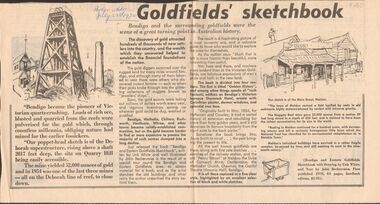
Newspaper - GOLDFIELDS SKETCHBOOK ARTICLE, BENDIGO ADVERTISER, 23rd July 1970
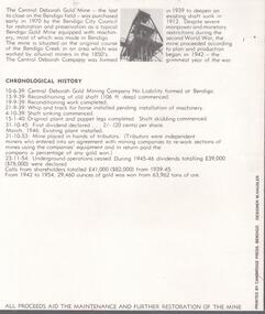
Newspaper article titled' Goldfields' sketchbook. Article on book release ' Bendigo and Eastern Goldfields Sketchbook with Drawings by Unk White and text by John Bechervaise, first published 1970, 64 pages, hardback edition, $1.95. Extract from article ' our poppet-head sketch is of the Deborah superstructure, rising above a shaft 2017 feet deep, the site on Quarry Hill being easily accessible. The mine yielded 52,000 ounces of gold and in 1954 was one of the last three mines all on the Deborah line of reef, to close down'Bendigo Advertiser July 23rd 1970.bendigo, mining, gold discovery, 'bendigo advertiser -
 Bendigo Historical Society Inc.
Document - MARKS COLLECTION: MINING LEASE BLOCKS 1873
Plan mining lease blocks 1873, timber hanger on top two brass rings, securing tape, round timber holder on bottom, scroll. On top Schedule of Mining Lease Blocks shown on the plan of the Sandhurst Gold Field, Published May 1873' Names of mining Companies listed with identifying number and area of mine site. E.g. '447 Johnson's Reef Gold Mines 7a, 2r, 8 p (acres, roods, perches). Number linked to the mine site shown on Sandhurst Gold Field map.bendigo, mining, mining lease blocks 1873 -
 Bendigo Historical Society Inc.
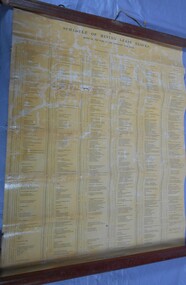
Document - CENTRAL DEBORAH GOLD MINE: COMPLIMENTARY GUIDE TO THE CENTRAL DEBORAH GOLD MINE
BHS CollectionBlack and white bifold document, on front of document 'Complimentary guide to the Central Deborah Gold Mine'. Inside is a map and numbered features of the mine site with interpretive information.bendigo, mining, central deborah gold mine -
 Bendigo Historical Society Inc.
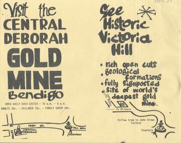
Document - CENTRAL DEBORAH GOLD MINE: ADVERTISING FLYER
BHS CollectionA4 advertising flyer,yellow background, black text. 'Visit the Central Deborah Gold Mine Bendigo' 'See Historic Victoria Hill'. Handrawn mud maps for each site on bottom of page.bendigo, mining, crentral deborah gold mine -
 Linton and District Historical Society Inc
Photograph, Electro Hydraulic Dredge, Snake Valley, 1909
Black and white image of workmen at electro hydraulic dredge Snake Valley mine site. Image has been mounted on dark brown card. Electro hydraulic dredge Snake Valley Victoria 1909. J.M.C. Bennett was an engineer back at the main base, at Dawson's Dam on the Carngham Road, bet Linton and Snake Valley. These dredges were used for getting gold. The streams of water under high pressure just washed the hills and ground away. This dredge closed down early 1910. 200 H.P. Motors were used and 10 in. pumps.electro hydraulic dredge, dredging, sluicing, mining, gold, miners, mining equipment, snake valley -
 Bendigo Historical Society Inc.
Document - DIAMOND HILL, GLASGOW GOLCONDA REEF GOLD MINE
BHS CollectionDescription of the heritage values of the Glasgow Golconda Reef Gold Mine sites. Information taken from 'On My doorstep' website ( no longer available, 10/2022)bendigo, mining, glasgow golconda -
 Bendigo Historical Society Inc.
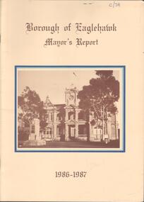
Booklet - Kangaroo Flat Gold Mine Collection: Borough of Eaglehawk Mayor's Report 1986-87, 1986-1987
Twenty page Mayor's Report, Borough of Eaglehawk, 1986-1987. Yellow cover, brown text, centre front sepia image of the Town Hall, Eaglehawk. Inside front cover, letter attached from Borough Of Eaglehawk to the Secretary of Bendigo Mining Corp., Victoria Street, Eaglehawk: attention is drawn 'to page 14 of the Report which covers the resurgence of gold mining activity in the Borough' Page 14 describes Western Mining Corporation's prospecting of the 1000 old mines in the Eaglehawk area to discover how much gold is left. 'The first new headframe seen in Central Victoria for 50 years has just been erected at the site of the Wlliams United mine in Eaglehawk' The company is pumping out 10 million litres of water a day to uncover the old workings' The Mayor of 1986-1987 Cr W. Carney, first woman Councillor (1977) and first woman Mayor for Eaglehawk ((1986-87).bendigo mining nl, goldfield, goldmining, production, eaglehawk borough, mayor of eaglehawk, cr. carney, williams united -
 Bendigo Historical Society Inc.
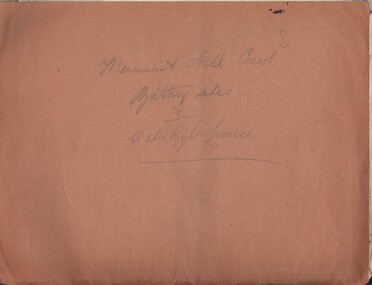
Document - MCCOLL, RANKIN AND STANISTREET COLLECTION: MONUMENT HILL CONSOL. BATTERY SITES & WATER RIGHT LICENCE
Documents: Manilla folder - licences to treat tailings with various plans and notes attached. Various notes - tailings licences Central Nell Gwynne and Monument Hill. Plans for areas applied for on leases 10852, 10166,10423,10238. Plans - area applied for tailings licence applications for leases/water right licences. Prospectus Nell Gwynne(BML) Mines N/L. Various notes relating to above Monument Hill Consol. Battery sites and water right licence.MCCOLL RANKIN & STANISTREETbusiness, gold mining, mccoll rankin & stanistreet, monument hill gold mine, battery, water right -
 Bendigo Historical Society Inc.
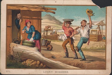
Postcard - WES HARRY COLLECTION: LUCKY DIGGERS
From a set of ten plates, the plates are: 1. Lucky diggers -- 2. Clearing the forest -- 3. Spearing emus -- 4. The stockrider -- 5. The vineyard -- 6. A pannikin of gold -- 7. Throwing the boomerang -- 8. Opossum hunting -- 9. Washing tailings -- 10. Teamsters' rest. The prints are numbered 1-10 and individually titled. Also available online http://nla.gov.au/nla.obj-139535117 U1526-U1535.A colour or coloured print of some lucky diggers dancing in the street with some smiling onlookers. In the background there are some tents and two windlasses. On the bottom left of the card is printed No. 1, indicating that this is one of a series. postcard, mine site, diggers, mining camp -
 Ballarat Heritage Services
Photograph - Image - Black and White, Golden Point, Ballarat
Black and white image showing the site of the earlies discovery of first rate mining importance to Australia. The gold occurs in gravel lying on Lower Palaeozoic slatesgolden point, ballarat, gold, geology, gold discovery -
 Bendigo Historical Society Inc.
Photograph - Kangaroo Flat Gold Mine Collection: photos of Woodvale site, Daly property, pre dam construction, 1986
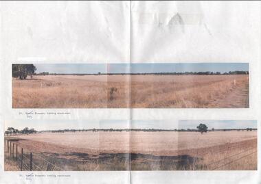
Photographs taken at the time of the purchase by Western Mining Corporation of the property owned by G.P. Daly of Raywood Road, Woodvale, in 1986. The intent of the purchase was to provide land for the Woodvale ponds. Land size was 16 acres, known as Allotment 13, Section 3, Parish of Nerring. Paper with two colour photographs attached, each of three photos joined to show landscape view, of the property purchased from G.P Daly by Western Mining Corporation. Photographs show rural land, grassy paddocks with tree line in background. Barb wire fence visible in foreground of bottom photo. Top photograph is titled 23. Daly property looking south-east. Bottom photograph is titled 24. Daly property looking north east. woodvale, g.p. daly, western mining corporation, purchase -
 Bendigo Historical Society Inc.
Photograph - Kangaroo Flat Gold Mine Collection: Catherine Reef South shaft
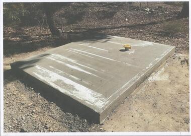
Kralcopic Pty Ltd, was a subsidiary of Bendigo-based company GBM Gold and had previously held mining licences around Bendigo, which incorporated sites including Kangaroo Flat, New Moon, Eaglehawk and the associated Woodvale Evaporation Ponds Complex. In August 2019, the Earth Resources Regulator decided not to renew Kralcopic’s three mining licences, due to the company’s inability to provide surety that it could finance its mining activities and site rehabilitation obligations. In October 2020, the company filed legal proceedings in the Supreme Court challenging the decision not to renew these licences. The Supreme Court later upheld the regulator’s decision not to renew the licences. On 23 April 2021, the Federal Court of Australia appointed KPMG as Kralcopic’s liquidators. On 14 May 2021, the liquidator lodged papers with the Australian Securities and Investment Commission (ASIC) to disclaim Kralcopic’s freehold land at Woodvale and parcels of land around the company’s former Bendigo sites, with the land to subsequently become Crown land. The Earth Resources Regulator has put a statutory exemption in place to preclude new mining licence applications on the sites while we undertake rehabilitation. The exemption also provides an opportunity for government to consider future uses of the sites in consultation with the City of Greater Bendigo and the local community. The Earth Resources Regulator holds rehabilitation bonds totalling $5.9 million, which it will use to rehabilitate the former sites.Colour photocopy of original photo. Image shows Catherine Reef South shaft with rectangular concrete capping. Ventilation pipe in concrete capping. On back in pencil: Catherine Reef South shaft with cap - Kralcopicwestern mining corporation, goldmining, capping, shaft, mining regulations, williams united shaft, kralcopic -
 Bendigo Historical Society Inc.
Photograph - Kangaroo Flat Gold Mine Collection: underground in Swan Decline, Kangaroo Flat Gold Mine, 2000
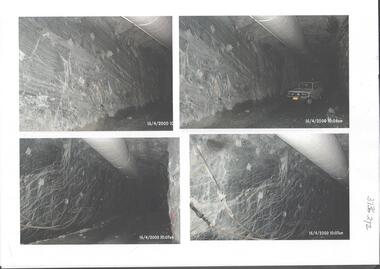
The modern mine is accessed via the Swan Decline, which commences at the Kangaroo Flat site on the southern outskirts of Bendigo and progresses in a north easterly direction between the Deborah and Sheepshead anticlines, reaching a depth of almost 1000 m below the City of Bendigo. Development of this decline commenced in 1998. Swan Decline closed and history preserved In a major rehabilitation milestone at Kangaroo Flat, the Swan Decline Bendigo’s primary gateway to underground mining, was permanently closed in December 2022. Important parts of Bendigo’s gold rush history were also preserved from the onsite office buildings with 19 boxes of records, and 1350 old photos being scanned and provided to the local historical societies and the Goldfields Library Corporation. A volunteer from the Bendigo Historical Society, Kay MacGregor, also scanned approximately 40 bookshelves of newspaper clippings to assist with recording and preserving geological drilling locations.Black and white photocopies of photographs of Swan Decline, showing some stages of underground construction. Eleven images on 3 pages, dated 16/4/2000 (10 a.m.) show decline walls, rock bolts and markout of tunnel shape. One image shows a utility in the tunnel. Final three images on one page, have notations on the photos: 'opposite SP18 LHS decline', 'just up from previous 3 box positions' and 'just up from tank, same side' On bottom RH side 'spots for scale attention, IT required, all lower decline.' All three images dated 12/6/2000.goldmining, kangaroo flat gold mine, western mining corporation, unity mining, swan decline -
 Bendigo Historical Society Inc.
Photograph - Kangaroo Flat Gold Mine Collection: Deadhorse Gully, Sydney Flat Creek March 1986
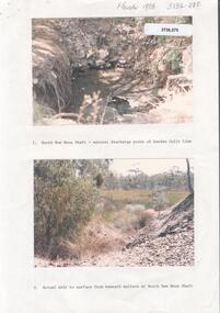
Colour photographs, seventeen images on nine page. Images labelled as follows : 1. North New Moon shaft - natural discharge point of Garden Gullly line 2. Actual exit to surface from beneath mullock at North New Moon shaft. 3. Looking into Deadhorse Gully from mullock heap at North New Moon site. 4. Deadhorse Gully downstream of WMC Weir. 5. Sydney Creek track crossing - impassable ford. 6. Sydney Creek looking downstream from ford. 7. Sydney Creek looking upstream from road near Recreation Reserve (12 inch pipe under road). 8. Sydney Creek looking downstream from same point. 9. Sydney Creek - Camp Road, looking upstream.. 10. Sydney Creek - Camp Road, looking downstream. 11. Sydney Creek - Camp Road Culverts. 12. Sydney Creek - Pyramid Road Bridge, looking upstream. 13. Sydney Creek - Pyramid Road Crossing looking downsteam. 14. Sydney Creek - rail crossing, looking upstream. 15. Sydney Creek - rail crossing, looking downstream. 16. Sydney Creek - Airstrip road, looking upstream. 17. Sydney Creek - Airstrip Road, looking downstream 12 inch pipe under road. Lined paper, in blue pen 'Deadhorse Gully-Sydney Flat Creek, March 1986, Photos of Deadhorse Gully/Sydney Flat Creek'kangaroo flat gold mine, deadhorse gully, sydney flat creek, unity mining, water discharge, north new moon, camp road, pyramid hill road, eaglehawk -
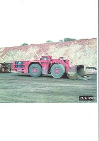 Bendigo Historical Society Inc.
Photograph - Kangaroo Flat Gold Mine Collection: mining equipment, 21st May 1999
A bogger is a heavy-duty piece of equipment used in underground mining to transport rocks, ore, and other materials from the digging face to processing facilities or loading areas. A bogger operator is an individual who controls the machinery used to transport materials.Colour photocopy of original photo. Image shows red load haul dump loader, pictured parked on a mine road at the Kangaroo Flat Gold Mine site. Date stamp on bottom RH corner: 21/5/1999.western mining corporation, goldmining, capping, shaft, mining regulations, kangaroo flat gold mine, 1999 -
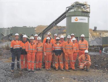 Bendigo Historical Society Inc.
Photograph - Kangaroo Flat Gold Mine Collection: Unity Mining employees
A3 laminated sheet with colour photographs of mine personnel. Fourteen men and one woman dressed in orange high-vis clothing and wearing hard hats. In background, part of processing plant with 'Unity Mining Limited' on side of tank. Kangaroo Flat Gold mine site in far background. kangaroo flat gold mine, bendigo mining nl, new bendigo gold project, goldmining, personnel, doug buerger, colin burns, unity mining -
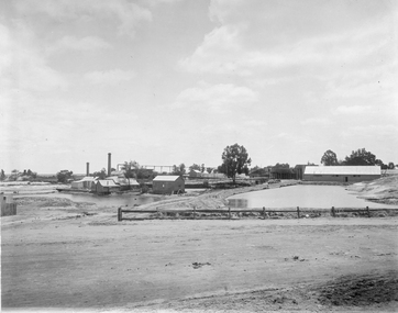
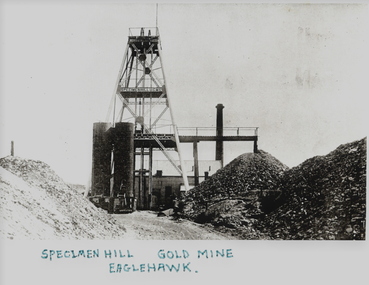 Bendigo Historical Society Inc.
Photograph - SPECIMeN HILL GOLD MINE
Black and white photograph. Poppet head with tubular steel legs and two stages lattice stays to braces. Winder house overhead tramway and mullock dump. Chimney at rear. Two tubular steel storage bins. Inscriptions:on site - 'Specimen Hill U G M Co', On front - bottom of photograph 'Specimen Hill Gold Mine, Eaglehawk', on rear - '22', 'Speciment Hill Mine Eaglehawk'.mine, gold, specimen hill (eaglehawk )., bendigo, specimen hill, gold mine, eaglehawk, mines and mining, mine, mines, mining, poppet head -
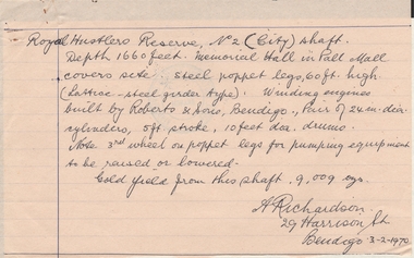 Bendigo Historical Society Inc.
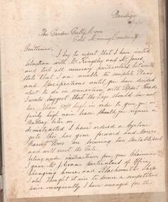
Document - ALBERT RICHARDSON COLLECTION: HANDWRITTEN report ROYAL HUSTLERS RESERVE
Hand written letter signed by A. Richardson, 29 Harrison Street, Bendigo - 03/02/1970. Royal Hustler Reserve No. 2 (lift) shaft. Depth 1660 feet. Memorial Hall in Pall Mall covers site. Steel poppet legs, 60 ft high (lattice-steel garden type). Winding engines built by Roberts and Sons, Bendigo. Pair of 24 in. clear cylinders, 5ft stroke, 10ft ? drums. Note 3rd wheel on poppet legs for pumping equipment to be raised or lowered. Gold yield from this shaft 9,009 ounces.person, mining, albert richardson -
 Bendigo Historical Society Inc.
Administrative record - Garden Gully and Moon Extended Gold Mining Company, Manager's Report Book, 1934 - 1935
Blue hard cover book, red binding on spine, one hundred and eighty eight pages of which forth eight are used. White label on front cover, no name of Company recorded. Inside front cover, affixed to front page, is a letter from Alfred Jorgensen, addressed to the Garden Gully Moon Gold Mining Company with details of his visit to the mine site at Sebastian; further letter affixed to page 2. Subsequent pages contain hand written Mine Manager's reports, by L.C. Bentley, dating from 21st December through to June 19th, 1935. Further reports by Alfred Jorgensen (pages 17 and 19) are inserted in the book. Mine Manager's book forms part of the Margaret Roberts Collection of Mining records.bendigo, margaret roberts, mccoll, sebastian, l.c. bentley, alfred jorgensen, rankin and stanistreet, legal managers, garden gully and moon gold mining company -
Clunes Museum
Book, PINNACLE PRINTING CO. PTY.LTD, VICTORIA 150 YEARS OF GOLD, 2001
VICTORIA 150 YEARS OF GOLD HISTORYGOLD COVERED BOOK - VICTORIA 150 YEARS OF GOLDnon-fictionVICTORIA 150 YEARS OF GOLD HISTORYlocal history, document, book, gold, mining, gold, mining, history -
 Bendigo Historical Society Inc.
Slide - HORWOOD COLLECTION: SOUTH MOON, c1965
Originally called Graham's South Moon Mine was situated on the Garden Gully Reef, Eaglehawk. Initially owned by George William Graham (1827-1896) who was born in England. George moved out of mining in 1855 when he opened a hotel and store at Milkmaids flat and later he opened a business in Emu Creek. He retired from business in 1870 but then invested in various mining enterprises. HE married twice in 1852 and 1878.Horwood Collection - South Moon. Some of the remains at the site of the South Moon Mine. Markings; The remains of the state battery South Moon. OCT65Kodakmine, gold, south moon, horwood collection - south moon. some of the remains at the site of the south moon mine -
 Stawell Historical Society Inc
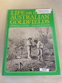
Book, Derrick I. Stone & Sue Mackinnon, Life on the Australian Goldfields, 1976
Early Photographs of mining towns and Sites as well as people, throughout Australia.Hard Green cover with b/w photo of two miners with pans and hats. Life on the Australian Goldfields. Derrick I. Stone Sue Mackinnonstawell gold mining -
Bendigo Historical Society Inc.
Book - AUCTION SALES: MINING CATALOGUE AUCTION SALES
Blue, black & white Woolstar exercise book with black & white check pattern to the left and a world globe over the top. Name on the front: A Richardson. Written on the front: Mining Catalogue Auction Sales. Book contains Lot numbers and description for auction sales at various mines. Mines mentioned are: Central Blue Gold Mine 19/2/42, Big Blue 23/11/1938, South Blue, Hercules Consols 19/2/1942, South Virginia 19/2/42, New Prince of Wales 5/2/48, Golden Carshalton G M 19/12/1957, North Virginia 3/5/57, North Nell Gwynne 25/2/53, South Shaft Diamond Hill, New Don 21/10/48, Sheepshead Battery Site 21/10/48, Forbes Carshalton 9/7/47, South Virginia 9/7/47, East Clarence 31/8/49?, Deborah Surplus Equipment 31/8/49, Deborah No 2 Shaft, North Deborah 31/8/49, Hercules Main Shaft 19/6/1950, Stanfield Shaft 20/6/1950, United Crushing Coy Battery (Unity Carlisle) 20/6/1950, Toolleen Gold Mine 23/2/1950, Ironbark Gold Mine 6/10/49, Ironbark South 1/12/49, Hercules New Chum 1/12/49, Great Southern Gold Mine 10/4/47, New Chum Syncline 2/3/1950, Deborah Associated 19/4/195? And the Deborah Consolidated 19/4/1950. Further information of Bendigo Mines from The Gold Mining Registry Guide to Bendigo Mines by H Kirkwood, Eaglehawk. Published by W. Welch. Mines include Lazarus New Chum Reg'd & Lazarus New Chum No 1, Princess Alexandra, Ellenborough, Trio-Hauling Coy, South Catherine Reef G. M. C., Princess Alice, Central Catherine Co,Cravens New Chum Co N. L., Garibaldi Mining and Crushing Co, Williams United, Catherine Reef Claimholders G. M. N. L., New Chum & Victoria Reef, Johnsons (Garden Gully) Line, United Ulster, Garden Gully Rly Reserve, South Ulster, Ulster and Cosmopolitan Coys, Golden Gate and Lansell'sBig 180. Some information on the Moon Mines 24/6/67 South New Moon, New Moon, Nth New Moon and New Moon Consolidated.In the reverseof the book is some information on the Lazarus New Chum Mine, Lazarus No 1 and Lazarus Mines. Also mentioned are New Chum Rly and Victoria Quartz. In 1895 a large gold bearing reef in Lazarus at 3000 feet. Also Some extracts from E. C. Dunn's Report 13/8/92 on the Lazarus Mine Old Shaft and Lazarus Main Shaft at various depths. Book not located on 6.3.25. Typed notes from book are in folder.book, bendigo, mining auction sales, auction sales, mining catalogue auction sales, a richardson, central blue g m, big blue, south blue, hercules consols, south virginia, new prince of wales, golden carshalton g m, north virginia, north nell gwynne, south shaft diamond hill, new don, sheepshead battery site, forbes carshalton, south virginia, east clarence, deborah, deborah no 2 shaft, north deborah, hercules main shaft, stanfield shaft, united crushing coy battery (unity carlisle), toolleen gold mine - toolleen, ironbark gold mine, ironbark south, hercules new chum, great southern gold mine, new chum syncline, deborah associated, deborah consolidated, j h curnow, miss kirkwood, the gold mining registry guide to bendigo mines, h kirkwood, w welch, lazarus new chum no 1, mr g armstrong, princess alexandra, h hectmann, ellenborough, amos arblaster, trio hauling coy, catherine reef g m c, w burnside, st mungo reef, princess alice, central catherine co, big catherine, belmont, cravens new chum co n l, wm w barker, c edwards, ellesmere, garibaldi mining and crushing co, henry von der heyde, w martin, williams united, wm cook, john chynowth, catherine reef claimholders g m n l, churchill davidson, edgar l rosman, new chum and victoria reef, johnsons (garden gully) line, united ulster, james mccoll, james quick, garden gully reserve, south ulster, ulster and cosmopolitan coys, golden gate, geo lansell's big 180, signal of a mine, mr langridge, e clarke, j hattam, a llewelly, n murray, a richardson, new moon, nth new moon, new moon consolidated, lazarus new chum, lazarus no 1, new chum rly, victoria quartz, lazarus, e c dunn -
 Bendigo Historical Society Inc.
Document - VICTORIA HILL - THE BENDIGO DIGGINGS, PRELIMINARY DRAFT FOR BROCHURE
BHS CollectionNine typed pages of notes on a preliminary draft for a brochure on the Bendigo Diggings. First part is the objective which is to preserve the mining history and to have exhibits in the places they were used, e.g. quartz mining machinery exhibited in a quartz mining area, not on an alluvial field. Part B is historical notes on the area. Part C is the Site - Victoria Hill area. Part D is Stage One which consists of carpark area, technological museum, restaurant, mineral haulage line, picnic ground, earthworks and planting over the area. Part E is Stage Two which will consist of the open-air exhibits, in the area surrounded by the mineral haulage line, and the Central Nell Gwynne mine on the west side of the site. Part F is Stage Three which will consist of the winery, the steam tram track, the lake, the wildlife sanctuary and various buildings associated with gold mining. Part G is Costing with the prices to be filled in. Parts H and I are the Appeal and the Committee. Details to be filled in. Notes prepared by Albert Richardson.mining, marketing, victoria hill, victoria hill, the bendigo diggings - preliminary draft for brochure, aust national travel association, tullamarine jetport, emu bottom homestead, kyneton historical museum, chinese joss house, eaglehawk museum, whipstick scrub, cairn curran reservoir, castelmaine historical museum and market hall, national trust, ballarat hiatorical park, echuca's hopwood gardens, swan hill folk museum, gibson's mount alexander no 2 squatting run, captain brown, chief commissioner wright, hustler's reef, thomas hustler, mining board, drainage of reefs act 1862, first world war, bendigo amalgamated goldfields, second world war, sandhurst, w c vahland, battery trams, horse trams, steam trams, electric trams, central nell gwynne mine, theodore ballerstadt, george lansell, new chum hill, ballerstadt's open cut, 180 mine, new chum syncline battery, william rae, victoria quartz, wittscheibe's 'jeweller's shop', luffsman and sterry, gold mines hotel, adventure, bendigo and district tourist association, bendigo city council, bendigo branch of the royal historical society of victoria, professor brian lewis, school of architecture and building at the university of melbourne, taylor horsfield, lord robert cecil, south australian gold commissioner -
 Stawell Historical Society Inc
Photograph, Magdala cum Moonlight Mine c1890 - Same as 1386-3
Black and White photo of Magdala cum Moonlight Mine.Mine site with open area and fence in foreground."Magdala" Herbert's Studio. Stawell stawell gold mining