Showing 3054 items
matching highway
-
 Bacchus Marsh & District Historical Society
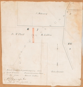
Map, Land required for a public highway near Rowsley, Victoria. Circa 1880s
This map indicates portions of land in the Parish of Gorrockburkchap near Rowsley which was required for construction of a road. The land required was leased to a Michael Laffan. Other blocks of land nearby owned or leased by D. McPhail and J. Mahoney are also indicated on the map. The date of the map is not known. However newspaper reports in the Bacchus Marsh Express on the 18 March 1882, page 3, column 3 mention land occupied by McPhail and Laffan near Rowsley in connection to the construction of a public road.Single page map showing land occupied by farmers D. McPhail and Michael Laffan which was required for a public highway. Scale 6 chains to inch. Part of a set of maps which are pasted into a bound volume containing 76 maps or plans in total. High resolution digital image stored on BMDHS computer network. Signed by Shire Engineer, W.E. Standfieldrowsley victoria maps -
 Melbourne Tram Museum
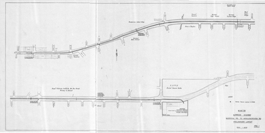
Drawing, Melbourne & Metropolitan Tramways Board (MMTB), "Burwood Highway Warragul Rd to Middleborough Rd - Preliminary Layout", c1975
Drawing, folded sheet to A4, titled "Burwood Highway Warragul Rd to Middleborough Rd - Preliminary Layout" showing the proposed layout of the tramway that was later built by the MMTB. Shows track alignment, cross streets, schools, the RSPCA, and a track into a proposed shopping centre complex where a bus interchange was noted. Part of a larger report.trams, tramways, burwood, burwood highway, new tramway, middleborough rd, buses -
 Ringwood and District Historical Society
Photograph, Warrandyte Rd. looking towards Maroondah Highway over Mullum Creek bridge - 1966
Typed below photograph, "Warrandyte Rd. looking towards Maroondah Highway - 1966". Backing sheet reads, "Warrandyte Rd. bridge over Mullum Ck. Church of England now on left - 1966". -
 Ringwood and District Historical Society
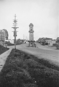
Photograph, Maroondah Highway Central, Ringwood. Clocktower at intersection of Warrandyte Road and Main Street, 1950
Black and white photograph (2 copies- 1 large, 1 small)Typed under large copy: "Maroondah Highway showing cnr Warrandyte Rd, clocktower at old position. Old Station Masters residence, and shops on right which are now demolished for Safeway store." -
 Ringwood and District Historical Society
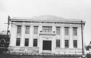
Photograph, Maroondah Highway Central, Ringwood. Old Town Hall, Ringwood, 1927
Black and white photograph. (2 copies)Typed below photograph: "Old town hall, Ringwood, Maroondah Highway Cnr. Melbourne Place. 1927". Written on backing paper: "Town hall Ringwood after completion - front only, 1927". -
 Robin Boyd Foundation
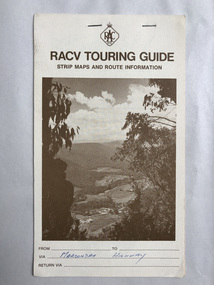
Map, RACV, RACV Touring Guide
Strip maps and route information for via the Maroondah Highway from melbourne to benalla.In blue pan Maroondah Highway.walsh st library -
 Ringwood and District Historical Society
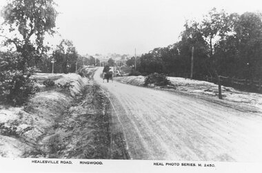
Photograph, Maroondah Highway East, Ringwood- c.1920. "Healesville Road, Ringwood" postcard featuring westward view along Whitehorse Road towards Mount Dandenong Road
4 photographs (2 large black and white, 2 small sepia postcard)Postcard labelled Healesville Road, Ringwood. Typed under large copy: "Looking down a dry Maroondah Highway from outside (eventual) Civic Centre site towards Mt. Dandenong Rd corner." -
 Ringwood and District Historical Society
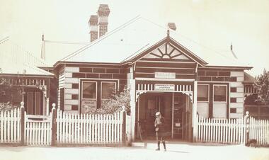
Photograph, Ringwood's second Post Office on Maroondah Highway 1906
Typed below photograph, "Ringwood's second Post Office on Maroondah Highway nearly opposite the station entrance. Later also became telephone exchange. Note the resident Dr. Craig's surgery on left - 1906". -
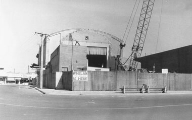 Ringwood and District Historical Society
Photograph, Maroondah Highway Central, Ringwood. Ringwood Town Hall Demolition - 1971
Black and white photographWritten under photograph: "Ringwood Town Hall demolition- 1971". Midway Arcade wall to the right, shops in Maroondah Highway to left via Melbourne Street. "Whelan the Wrecker is here" sign on the rear wall. -
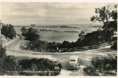 Lakes Entrance Historical Society
Postcard - Princes Highway Kalimna, Valentine Series, 1930c
Black and white postcard of a bend in the Princes Highway as it winds around Jemmys Point, car parked beside highway, two people leaning on post and rail fence, Bullock Island and Lakes Entrance in the distance. Lakes Entrance VictoriaPrinces Highway Lakes Entrancefences, transport, roads and streets -
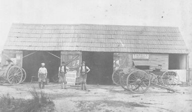 Ringwood and District Historical Society
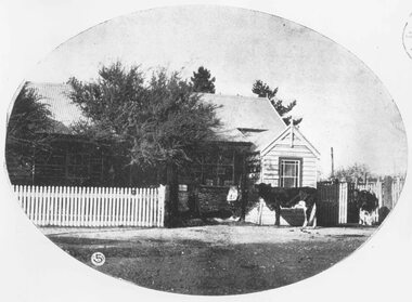
Photograph, Maroondah Highway West, Ringwood- 1878. Thomas Grant's original blacksmith's shop
Black and white photographTyped below photograph, "Mr. Thomas Grant's original blacksmith's shop in Maroondah Highway Ringwood - 1878. West of Ringwood St. on south side near drive-in shopping centre. (Opposite new ANZ bank). -
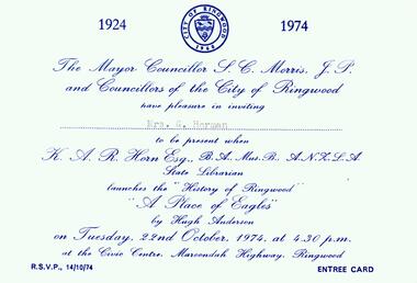 Ringwood and District Historical Society
Photograph, Invitation from the Ringwood Council of the City of Ringwood on 22nd October 1974. From the Mayor Cr S Morris JP and the Councillors to Mrs G Horman. Official launch of the "Place of Many Eagles" by KAR Horn BA Mus B State Librarian at the Civic Centre, Maroondah Highway, Ringwood
Invitation from the Ringwood Council of the City of Ringwood on 22nd October 1974. From the Mayor Cr S Morris JP and the Councillors to Mrs G Horman. Official launch of the "Place of Many Eagles" by KAR Horn BA Mus B State Librarian at the Civic Centre, Maroondah Highway, Ringwood. All material is from Gwen Horman’s three albums that she owned. -
 Ringwood and District Historical Society
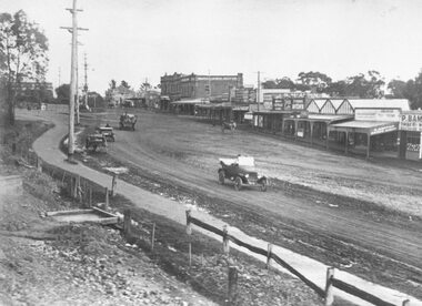
Photograph, Maroondah Highway Central, Ringwood. Main street, Ringwood c1924. showing cars and horse-drawn carriages in front of shops - undated but possibly c1924
Black and white photograph (2 copies- 1 large, 1 small)Written on rear of backing sheet of large copy: "Early days of Ringwood commercial centre. Present frontage of Eastland to Maroondah Highway." Image shows Main Street with motor cars and horse drawn vehicles in front of shops. -
 Ringwood and District Historical Society
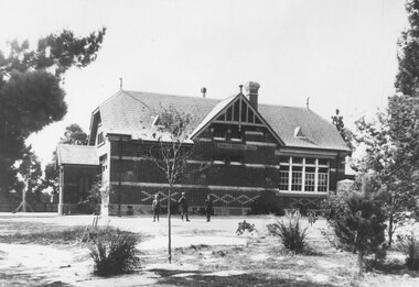
Photograph, Ringwood State School No. 2997 viewed northward from Maroondah Highway. C1912 After building partitioned
Black and White School Building Photographedearly c1912, following structural alterations by partitioning the original single room into two classrooms during that year (According to Ringwood Primary School History) See VC# 6876 et al for images before the partitioning. Typed below photograph, "Ringwood State School No. 2997 seen from Maroondah Highway. Entrance was from Ringwood St. opposite end of Charter St. School was behind site of present Coles store. c1900". (Note: Actually c1912) -
 Ringwood and District Historical Society
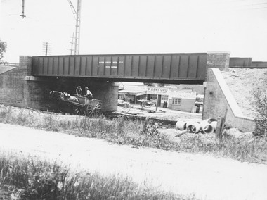
Photograph, Maroondah Highway Central, Ringwood. Construction of Warrandyte Road railway viaduct, 1923
Black and white photograph (2 copies)Typed below photograph: "Construction of Warrandyte Road railway viaduct, Ringwood - 1923." Maroondah Highway shops in background later redeveloped as the site of Safeway supermarket then Officeworks office supplies outlet, prior to Eastland Shopping Centre expansion in 2015. -
 Ringwood and District Historical Society
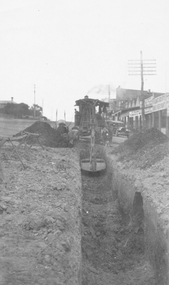
Photograph, Maroondah Highway Central, Ringwood. Laying water main in Main Street, 1935
Black and white photographImage shows excavator digging trench for water main on Main Road (Maroondah Highway. Towards the west, near the corner of Warrandyte Road. The Ringwood Stationmaster's house is on the left, Bamford's timber yard, Coffee Palace and other shops on right. -
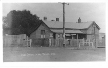 Lake Bolac & District Historical Society
Photograph - Black and white photograph, Lake Bolac Post Office - Glenelg Highway Lake Bolac c.1940s, c1940
Lake Bolac Post Office Glenelg Highway. Initially the Post Office was established at the Store in 1868. This official weatherboard building was opened in 1887 incorporating a telegraph office, money order office and post office savings bank. The Post Office business was relocated in 1944 and the building was used as a private residence with the front room leased to Dennys Lascelles. Note the horse hitching rail and kerosene street light.Photograph depicting a weatherboard building across a road. The building is fenced. In front of the building there is a telegraphic or electric post and a lamp post.lake bolac, post office, glenelg highway, dennys lascelles -
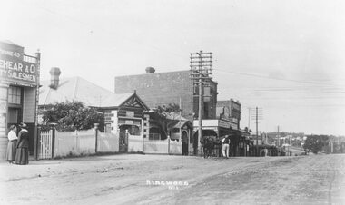 Ringwood and District Historical Society
Photograph, Maroondah Highway Central, Ringwood. Looking east from opposite station entrance, 1918
Black and white photograph (3 copies- 2 large, 1 small)Typed below one large photograph: "Maroondah Highway Ringwood 1918 looking east - opposite station entrance. Old Post Office to left." Written on back of small photograph: "c1920. Godbehear was brother to Rev. Godbehear who died 1945". -
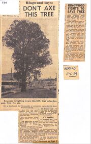 Ringwood and District Historical Society
Newspaper, Fight to save tree near Ringwood Timber on Maroondah Highway, late 1950s
Two newspaper articles, re the fight to save tree near Ringwood Timber on Maroondah Highway, late 1950s. The Yellow Box tree was located west of Ringwood timber, outside Bill Patterson's Motors near the New Street intersection. The fight was led by Cr Ben Hubbard, the secretary of the Ringwood Horticultural Society, Mr Kearsley, but was eventually lost. The articles are from The Herald and dated December 1957 and 11th June 1959. -
 Stawell Historical Society Inc
Photograph, Longfield Street / Western Highway 1866
Part of a collection of Photographs by Mr. O.G. Armstrong as commissioned by the Shire of Stawell for the Inter-colonial and Paris Exhibition in Melbourne in 1866. Longfield Street Stawell (now the Western Highway) looking towards Sister Rocks and Ararat. Pleasant Creek Court House and Shire Hall are on the right, as is a shop on the corner of Seaby Street and Longfield streets. On the left is the Camp Hotel, the Constitution Hotel and the Shamrock Hotel on the far Side of Seaby Street. stawell streetscape -
 Ringwood and District Historical Society
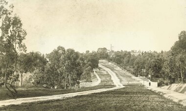
Photograph, Maroondah Highway East, Ringwood- 1900. Sandy Creek Bridge, Maroondah Hwy
3 photographs ( 2 large black and white, 1 small sepia)Written on all copies: "New Sandy Creek Bridge". Typed below large photograph: "Maroondah Highway Ringwood looking east. To right of bridge is now Ringwood Lake. Mount Dandenong Road turnoff to right at top of rise with antimony mine in background - 1900". -
 Ringwood and District Historical Society
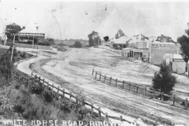
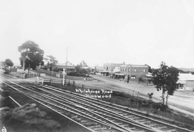
Photograph, Maroondah Highway Central, Ringwood. Whitehorse Road looking west. 1908
Photographs (3 copies- 2 black and white, 1 sepia postcard).Typed below one photograph: "Maroondah Highway Ringwood looking west. Warrandyte Rd coming in from right. 1908." Written on back of another photograph: "Fence divides two levels of road opp Warrandyte Rd looking west. Station Master's house on left." -
 Ringwood and District Historical Society
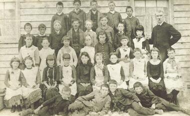
Photograph, Mr. E. F. Cass and pupils at Ringwood's first school - Cass State School 1451, located at corner Everard Rd. & Maroondah Highway - 1883. Mr. Cass was Head Teacher at the school 1874-1894
Typed below photograph, "Mr. E. F. Cass and pupils at Ringwood's first school, corner Everard Rd. & Maroondah Highway. 1883." Other notes on backing sheets read, "Cass State School 1451, Mr. E. F. Cass (Head teacher 1874-1894)". -
 Flagstaff Hill Maritime Museum and Village
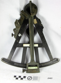
Octant, Late 18th to mid-19th century
An Octant is a doubly reflecting navigation instrument used primarily by sailors to measure the angular distance between two visible objects and was a forerunner of the sextant. The name comes from the Latin octo, or “one-eighth of a circle,” for the Octant’s arc which spans 45°, or one-eighth of a circle. The primary use of an Octant is to measure the angle between an astronomical object and the horizon for the purposes of celestial navigation. The estimation of this angle is known as sighting or shooting the object, or taking a sight. The angle, and the time when it was measured, can be used to calculate a position line on a nautical chart (latitude), for example, sighting the Sun at noon or Polaris at night (in the Northern Hemisphere) gives an angle by which the latitude can then be estimated. Sighting the height of a landmark on land can also give a measure of distance. History: The principle of the Octant as an instrument to measure ones latitude was first implemented around 1742-present but was superseded by the improvement of the octant to a sextant, a very similar instrument, better made and able to measure bigger angles 120°, allowing the measurement of Luna distances to give longitude when used with an accurate chronometer. The sextant started to appear around 1730 and had been attributed to by John Hadley (1682–1744) and Thomas Godfrey (1704–1749), but reference to the sextant was also found later in the unpublished writings of Isaac Newton (1643–1727). Earlier links can be found to Bartholomew Gosnold (1571–1607) indicating that the use of a Sextant for nautical navigation predates Hadley's implementation. In 1922, the sextant was modified for aeronautical navigation by Portuguese navigator and naval officer Gago Coutinho. Henry Hemsley was a lesser-known instrument maker and optician working in London in the late 17th and early 18th century. However, it should be noted that there were two Henry Hemsley opticians and instrument makers around this period. (Henry Hemsley 1, 1786-89, who had premises at 85 Fleet St London and Henry Hemsley 2, 1828-56), whose workshop was at 135-138 Radcliff Highway London. Therefore, based on the inscribed workshop address Henry Hemsley 2 is responsible for making this example.The octant is representative of its type and although not fully complete it demonstrates how 18th and 19th-century mariners determined their latitude on a chart to navigate their way across the world's oceans in the 18th and 19th century. It also demonstrates the skill and workmanship of the early instrument makers that operated from London at this time and provided most of the navigational instrumentation use by commercial and military navies of the time.Octant, ebony wooden frame and handle. Scale is missing from recess in frame. "H. Hemsley 135-138 Ratliff Highway, London", no box"H. Hemsley 135-138 Ratcliff Highway, London"flagstaff hill, warrnambool, shipwrecked-coast, flagstaff-hill, flagstaff-hill-maritime-museum, maritime-museum, shipwreck-coast, flagstaff-hill-maritime-village, navigation, navigational instrument, instrument used for navigation, sextant, henry hemsley, instrument maker, london, octant -
 Ringwood and District Historical Society
Photograph, Ringwood Post Office in 1908/9. Maroondah Highway
Typed below one copy, "Ringwood Post Office in 1909. Maroondah Highway - Opposite present Holeproof site". Other copy of same photograph reads, "Ringwood original Post Office opposite Guyatts new store - 1908". Backing sheet states, "Ringwood P.O. Weekly Times 4 July 1908". -
 Ringwood and District Historical Society
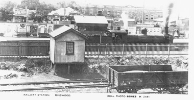
Photograph, Maroondah Highway Central, Ringwood. Railway Station, Ringwood- c1920
Photograph (3 copies- 2 large, 1 small postcard)Typed below large photograph: "Overlooking Ringwood railway station looking north from Station Street. c1920." Inscription beneath photograph reads, "Railway Station. Ringwood. Real Photo Series M. 2451". Image shows steam locomotive in station, with platform advertising boards, and shops fronting Maroondah Highway. -
 Ringwood and District Historical Society
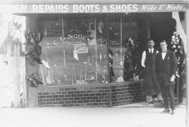
Photograph, Maroondah Highway Central, Ringwood. C.G. Noden Shoe Shop, c1920's
Black and white photograph (2 copies- 1 large, 1 small) Typed below large photograph: "Shoe shop in Maroondah Highway 1920s." Image shows 2 men standing in doorway of shop. Writing on window reads, "C.G. Noden, returned soldier." Included with photograph is a copy of Australian Military Forces enlistment details for Charles George Noden dated 20/8/14. -
 Ringwood and District Historical Society
Photograph, Maroondah Highway Central, Ringwood. Main St, looking west showing old railway crossing and station masters home in centre - 1918
Black and white photograph (2 copies)Typed below one copy: "Main St. Looking west showing old railway crossing and station masters home in centre - 1918". Typed below other copy: "Maroondah Highway looking west c1918. Showing old railway level crossing at left. Station masters residence in centre. Shops to right now Eastland car park." -
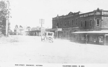 Ringwood and District Historical Society
Photograph, Maroondah Highway Central, Ringwood. Main Street looking west. Adelaide St. corner on right. c1924
Photograph (3 copies- 2 large black and white, 1 sepia postcard) Typed below one of the photographs, "Maroondah Highway looking west. Shops to right now Eastland carpark. Shops in centre are opposite station entrance" Typed below other copy: "Main St. looking west. Adelaide St corner on right. c1924." Typed on sepia postcard copy: "Main Street, Ringwood, Victoria. Valentines Series. M4801." -
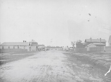
 Hume City Civic Collection
Photograph
The old Calder Highway before the construction of the duplication of the Calder Highway between the Railway crossing and Plumpton Road.A coloured panoramic view of the old Caler Highway at Diggers Rest. It is unmounted.old calder highway, diggers rest, plumpton road, railways, george evans collection