Showing 189 items
matching hill 60
-
 Melbourne Tram Museum
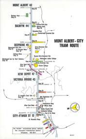
Map, Melbourne & Metropolitan Tramways Board (MMTB), Set of 15 tram route maps, 1977 to 1979
Series of 15 colour route maps for various tram lines or groups of tram lines for the MMTB. Some have the Transport Information Centre telephone printed on them, others have a label stuck on. Some are finished with a plastic laminate finish on either one or both sides. Show the major cross streets, parks, schools, other tram routes, major stop numbers and railway lines. Two copies of each held unless noted otherwise. .1 - Mont - Albert City - R11/77, shows routes 43. 47. 45. 44 .2 - Malvern, East Malvern, Carnegie and East Brighton Tram Routes (from St Kilda Junction) - R1/79 - shows routes 5, 3, 67, 66, 61, 62 and 64. .3 - Swanston St tram guide - R1/79 - lists all routes and route numbers that branch or cross Swanston St between Grattan St and St Kilda Junction. .4 - St Kilda Rd Tram Routes R12/77 - details South Melbourne Beach, route 1 and route 2 and St Kilda Beach routes 15, 16 and 55 otherwise shows were the various routes branch off St Kilda Road. Copy 1 has "P14909" in pencil in the bottom right hand corner. .5 - Kew - St Kilda Beach - R1/79 - Route 69. .6 - Footscray - Moonee Ponds - R3/81 - Route 82 .7 - Flinders St tram routes - R5/78 - North Balwyn, East Burwood, routes 48, 40, 41, Hartwell, 28, 74 and 75 .8 - William St tram routes - Route 55, 56 and 63 - South Melbourne Depot and Domain. copy 2 has "P14913" in bottom right hand corner. .9 - Toorak Camberwell and Glen Iris tram routes with Camberwell Junction and Malvern Town Hall, R1/79, routes 8, 7, 6, 72 and 73 shown. .10 - Swanston St tram routes - R12/77 - shows all the Swanston St routes, including East Coburg and Moreland. .11 - Bourke St tram routes - R4/77 - East Brunswick Blyth St and East Preston Tyler St and intermediate routes, routes 95, 96, 97, 90, 89 and 88. .12 - as for .11, dated 1/85, showing extension to La Trobe University - has Metropolitan Transit logo. Only 1 copy held. Also shows route 92 and 87. .13 - Batman Ave tram routes - R9/77 - Wattle Park, North Richmond and Prahran - routes 70, 71, 78 and 79. .14 - City route guide - R9/77 - showing all route numbers and destinations that passed through the CBD. .15 - Elizabeth St tram routes - R12/77 - Essendon Airport, West Maribyrnong, North Coburg lines, routes 50, 58, 60, 54, 57, 52. 49, 59, 18, 20 and 19. Copy 1 has "P14905" in pencil in bottom left hand corner.trams, tramways, maps, route guide, route numbers, routes, mont albert, route 43, route 47, route 45, route 44, route 42, malvern burke rd, east preston, carnegie, east brighton, south caulfield, route 5, route 3, route 67, route 62, route 64, route 66, glenhuntly tram depot, swanston st, st kilda rd, south melbourne beach, st kilda beach, route 1, route 2, route 15, route 16, route 55, kew- cotham road, route 69, route 79, route 82, footscray, moonee ponds, flinders st, north balwyn, kew, east burwood, burwood, hartwell, richmond, route 48, route 40, route 41, route 28, route 74, route 75, route 56, route 63, william st, west coburg, toorak, camberwell, glen iris, malvern town hall, route 72, route 73, route 7, route 8, bourke st, route 6, route 95, route 96, route 97, route 90, route 89, route 89, east preston, east brunswick, la trobe university, clifton hill, route 92, route 87, route 70, route 71, route 78, route 79, north richmond, prahran, wattle park, essendon airport, west maribyrnong, north coburg, route 50, route 58, route 60, route 54, route 57, route 52, route 49, route 59, route 18, route 20, route 19, batman ave -
 Melbourne Tram Museum
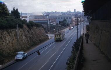
Slide - Set of 2, John Webster, 14/06/1960 12:00:00 AM
Set of two Colour slides Kodak, white cardboard of trams: .1 - an SW6 (route 42) car descending the Barkers Road hill through the cutting towards Victoria Bridge over the Yarra river, Has the Vickers Ruwolt factor in the background and the city skyline. .2 - SW6 893 (City Route 42), crossing the Victoria Bridge after leaving the Barkers Road cutting. Shows the overhead support structure on the bridge. Slide datedHand writing on rear in ink "14-6-60 - Retrieving a trolley pole Church St Hawthorn."trams, tramways, route 42, barkers road, sw6 class, bridges, victoria bridge, tram 893 -
 Ringwood and District Historical Society
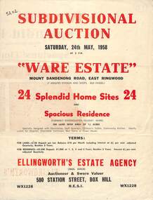
Flyer, Subdivisional Auction Sale Brochure, Ware Estate, East Ringwood, Vic. - 1958
Folded double-sided advertisement for auction of 24 home sites and existing residence on Saturday, 24th May, 1958, including locality map, subdivision layout, terms of sale, and summary of local facilities and services. Additional plan of lots 28-33 dated 26/10/60 by Licensed Surveyor for Kirkpatrick & Webber, 225 Maroondah Highway Ringwood headed Plan of Subdivision of part of Crown Allotment 26A Parish of Ringwood.Subdivision includes Mount Dandenong Road, Ware Crescent, Davey Drive, and Grey Road (later Grey Street). Timber residence included in the subdivision was formerly Ware Kindergarten Holiday Home. (Agent) Ellingworth's Estate Agency, 580 Station Street, Box Hill - (Phone) WX1228. -
 The 5th/6th Battalion Royal Victoria Regiment Historical Collection
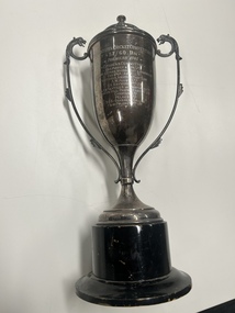
Award - Trophy, Trophy 3rd division cricket, 1940
3rd Division cricket competition 57/60 BN premiers 1940 citizens committee Geo. Pizzey & son ltd + 11 other sponsors. Double handled with dragon head caps on handles., black based and tiered lid. Inscription engraved into front of trophy 3rd Division Cricket Competition 57/60 BN. -Premiers 1940- Citizens Committee Geo.Pizzey & Son Ltd Messrs H.Byron Moore Day & Journeaux Cox Bros/Aust./LTD Victoria Amateur Turf club A.W.Allen Ltd. G.N. Raymond Tty Ltd Felt and Textiles of Australia Ltd Broken Hill Propriatry Coy Ltd Carreras Ltd Pelaco Ltd 3 D B Bonehead College Kiwi Polish Pty Ltfregimental property, 57/60 bn, ww2, trophy, cricket, 3rd division -
 Moorabbin Air Museum
Document (item) - Roland Jahne Collection - See Description for details
-
 Flagstaff Hill Maritime Museum and Village
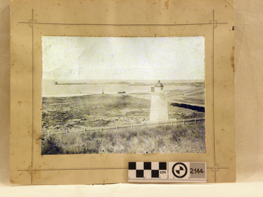
Photograph - Historical, maritime, Brookes' Photographic Union, Warrnambool Harbour (from the battery), 1895
This photograph shows the Lower Light at Flagstaff Hill, Warrnambool, in 1895, part of the Lady Bay Lighthouse Complex. The photograph is part of the Western Victoria collection produced in 1891 by Brookes' Photographic Union in Victoria. Brookes' Photographic Union was a collaboration of two brothers, Frederick Augustus Brookes and his brother Albert Edward Brookes. Frederick arrived in Victoria in the early 1880's. He and Albert formed the organisation to produce collections of photographs including the districts of Geelong, Gippsland and the Western Victoria. This photograph was taken and published just after the construction of the Warrnambool Breakwater. The image records a snapshot of the construction of the Warrnambool Breakwater, a construction that changed the history of the Port of Warrnambool, It is also a record of the Flagstaff Hill area and at that time.Photograph, sepia coloured rectangular shape, mounted between two sheets of cream card. Border of photograph is decorated with pen lines and design in corners. Subject is the Warrnambool Harbour, with a lighthouse on a hill in the foreground, a light coloured picket fence, the harbour with a moored vessel and a jetty. Produced by the Brookes' Photographic Union, and with the heading of Western Victoria. Inscriptions are on the reverse, on two stickers, a printed white label and a handwritten name.Stickers: "F.PA 60/2-74" "138" Label: "WESTERN VICTORIA / BROOKES' PHOTOGRAPHIC UNION / WARRNAMBOOL HARBOUR / (FROM THE BATTERY) Hand written in black: "B. Fisher"flagstaff hill, flagstaff hill maritime museum and village, warrnambool, maritime museum, maritime village, great ocean road, shipwreck coast, western district, western victoria, brookes' photographic union, frederick brookes, albert brookes, photograph, warrnambool harbour, warrnambool history, lady bay, port of warrnambool, b. fisher, 1895, maritime history, breakwater, warrnambool jetty -
 Narre Warren and District Family History Group
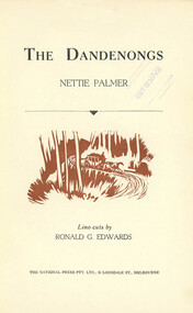
Book, Nettie Palmer, The Dandenongs by Nettie Palmer, 1953
Life in the Hills area; Towns of Dandenong, Emerald, Monbulk district60 p.; 23 cm. Dustcover has been removednon-fictionLife in the Hills area; Towns of Dandenong, Emerald, Monbulk districtrose charman's cottage, emerald victoria, monbulk vic -
 Narre Warren and District Family History Group
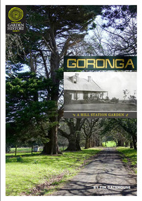
Book, Tim Gatehouse, Goronga : A Hill Station Garden, 2022
"Goronga is a farming property at Pakenham Upper, in the foothills of the Dandenong Ranges 55 kilometres from Melbourne. The property of 24 hectares (60 acres) was established as a farm by selectors in the 1870s and in 1889 was purchased by Melbourne residents William and Matilda Raleigh, who created a hill station garden around the new house they built adjoining the earlier farmhouse...." -- page 3.36 p.; 30 cmnon-fiction"Goronga is a farming property at Pakenham Upper, in the foothills of the Dandenong Ranges 55 kilometres from Melbourne. The property of 24 hectares (60 acres) was established as a farm by selectors in the 1870s and in 1889 was purchased by Melbourne residents William and Matilda Raleigh, who created a hill station garden around the new house they built adjoining the earlier farmhouse...." -- page 3. pakenham upper (vic.), goronga -
 Bacchus Marsh & District Historical Society
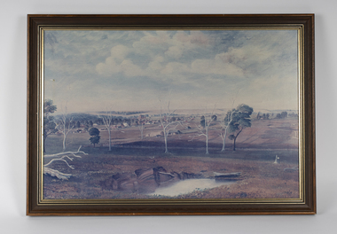
Painting, View of Bacchus Marsh from Stamford Hill circa 1880s
The date of the scene depicted in this painting has not been identified. The painting has no artist signature or date. The view depicted is from an area close to the present day Madden Drive in Bacchus Marsh. The angle of the view suggests the artists viewpoint may have been from a spot close to the intersection of Madden Drive and Muir Street looking east over the town. Several buildings constructed in the 1860s and 1870s can be seen in the painting. These include Saint Andrews Presbyterian Church (now Uniting Church), built 1865, Stone Villa in Bennett Street, the Bacchus Marsh Court House, the former National Bank and the Border Inn, all on Main Street, and in the distance Saint Bernard’s Catholic Church. Buildings such as Simon’s Garage erected in 1913, on the corner of Main Street and Grant Street are not shown. In the foreground running horizontally Grant Street can be seen. The view of Grant Street shows very few buildings. One house in the centre of the picture is Murdoch's Cottage. A brick house constructed in 1868 on the corner of Grant Street and Waddell Street. To the right of the picture along Grant Street no buildings are shown. The store built by John Jory in 1890 at 60-62 Grant Street which survives as a building in 2025 is not shown. Some allowance for artistic interpretation must be allowed but based on what the scene depicts it suggests a scene of Bacchus Marsh in the late 1870s or 1880s. Print reproduction of an oil painting. Framed. Undated. Unsigned. BMDHS Location: AR/B12/Beside (on floor)views bacchus marsh vic., paintings bacchus marsh vic., landscapes bacchus marsh vic.