Showing 644 items
matching implements
-
 National Wool Museum
Book, Sale by Description: a progress report on implementation
"Sale by Description: a progress report on implementation; report prepared by the advisory committee on objective measurement, Australian Wool Corporation, Dec. 1987." Relates to standardised descriptions of wool and wool measurements.woolclassing, australian wool corporation -
 City of Ballarat Libraries
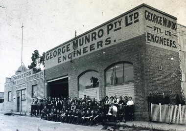
Photograph - Card Box Photographs, George Munro Pty Ltd Engineers, Ballarat circa 1935
The engineering works was located on Davey Street between Mair & Webster Streets. This was later to become Deutcher's, manufacturers of agricultural implements. About 50 employees sit out the front of the building.george munro pty ltd engineers, george munro, building, manufacturing, persons, work -
 City of Moorabbin Historical Society (Operating the Box Cottage Museum)
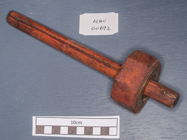
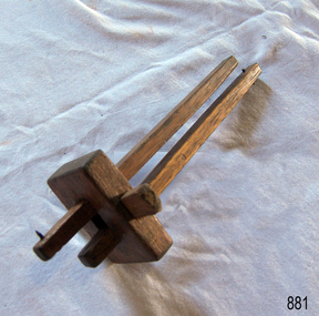
Tools, marker wooden gauge, c1900
A marking gauge, also known as a scratch gauge, is used in woodworking and metal working to mark out lines for cutting or other operations. The purpose of the gauge is to scribe a line parallel to a reference edge or surface. It is used in joinery and sheet metal operations.The gauge consists of a beam, a headstock, and a scribing or marking implement, typically a pin, knife, pen or wheel. The headstock slides along the beam, and is locked in place by various means: a locking screw, cam lever, or a wedge. The marking implement is fixed to one end of the beam.Early settlers in Moorabbin Shire had to be self reliant and made their own clothes and tools as they established homes and farms for their familiesc1900 A hand made wooden marker gaugeearly settlers, pioneers, market gardeners, moorabbin, bentleigh, brighton, cheltenham, tools -
 Warrnambool and District Historical Society Inc.
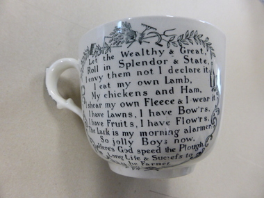
China, Cup & Saucer, Eary 20th century
This is a porridge set which probably dates from the early years of the 20th century. Porridge bowls and cups were particularly popular in Scotland at that time and would have been used in households in Australia throughout the 19th and early 20th centuries. These items have no known local provenance but are of interest as an example of the household china that was in use 100 years ago and was still being used for many decades after that time. They are attractive items and will be useful for display. These two items are a large cup and saucer made of china and used for porridge. The cup has colour floral and leaf scroll decorations inside the top rim, a piece of verse extolling the farmer and surrounded by black and white patterns, including farming implements, on one side of the cup and coloured farming implements in circles with the same verses in larger circles with a colour wheat sheaf in the centre on the other side of the cup. The saucer, more in the shape of a soup bowl, has the same colour floral and leaf decorations around the rim and the same farming patterns and verses in the centre. The handle has a black and white floral decoration The maker’s mark and name are on the bottom of the cup and saucer. ‘In God is Our Trust’ ‘The Farmers Arms’ history of warrnambool, porridge bowls -
 Greensborough Historical Society
Article, The Great Greensborough maths war, by Glenis Henderson nee Schultz, 2018_
Glenis Henderson taught at Greensborough Primary School at the time that Cuisenaire rods were introduced in maths teaching in the early 1960s. In this story Glenis relates some of the problems with implementing this new method.6 pages text, two colour photographsgreensborough primary school, cuisenaire rods, glenis henderson -
Port Melbourne Historical & Preservation Society
Plan - Swimming Baths, Port Melbourne, Plan of Proposed Baths, 1909
Originally held at Port Melbourne Town Hall. Intended for area between Town Pier and Lagoon. Plans drawn in March 1909 (see no. 452 pp 287and 416), but never implemented.Plan of proposed swimming baths at Port Melbourne, 1909 (unsigned)Corporation Swimming Bathsbuilt environment - recreational facilities, sport - swimming, arthur victor heath, town clerks -
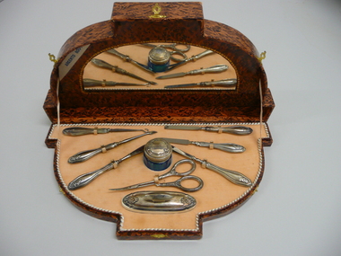 Bendigo Historical Society Inc.
Domestic Object - FAVALORO COLLECTION: MANICURE SET
Manicure set, continental silver in a faux wooden case with 3 small brass clasps & a mirror in lid, contains a small blue glass jar with silver lid and seven manicure implements plus a nail buffer all displayed on a apricot coloured velvet base. Hallmarks unreadable, 800.Argento 800-1000personal effects, manicure, manicure set -
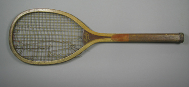 Tennis Australia
Racquet, Circa 1906
A wooden, late transitional flat-top racquet with a laminated convex throat. Inscription across throat on obverse: HENLEY. Inscription across right side of stem: THE BRIDGEPORT GUN IMPLEMENT CO./NEW YORK, U.S.A. Materials: Wood, Gut, String, Leather, Metal, Ink, Glue, Lacquertennis -
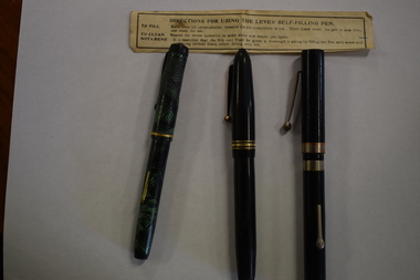 Warrnambool and District Historical Society Inc.
Functional object - Fountain Pens, Fountain Pen, 1940s
These fountain pens have no known local provenance but are good examples of the type of writing implements that replaced the use of pen and ink and came into popular use in the 1940s. They were superseded by the introduction of the ballpoint pen.These items are retained for display purposes.1 A mottled green and black fountain pen with a gold trimming on the screw top, a gold lever on the base that is lifted to fill the pen with ink and a gold clip on the lid for attaching the item to a pocket. Inside is a metal nib. .2 A black fountain pen with gold trimming and a gold clip on the screw top. There is some engraved printing on the base. Inside is a metal nib. .3 A black fountain pen with silver trimmings, a silver clip and catch and an image of a silver swan on the base. Inside is a metal nib. .2 Swan Leverless Pen Pat. No. 390585 Made In England Marie Todd & Co. Ltd. vintage writing implements, warrnambool history -
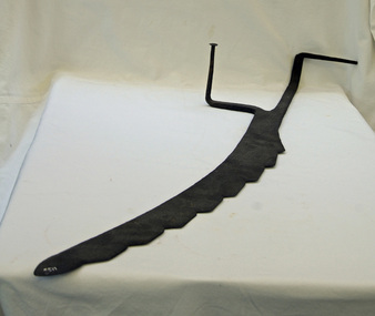 Orbost & District Historical Society
silage knife, late 19th, early 20th century
This knife would have been a common implement used in the Orbost farming community. It dates from the pre-mechanised era when silage and hay had to be cut by hand to be fed out to stock.Associated with the farming industry of the Orbost district.A flat iron blade with large serrations on one side, two iron handles which would originally have been covered with wood.farming-implement hay-knife silage-knife -
 Bendigo Military Museum
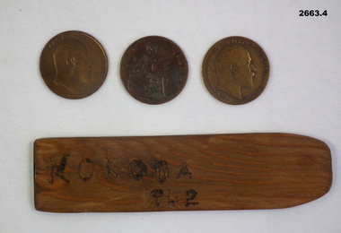
Leisure object - TWO-UP SET, 1) 1942; .2) 1908; .3) 1909; .4) 1910
.1) Kip - the tossing implement, timber rectangular shape, hand made with hard etched letters & numbers on one side. .2) - .4) All pennies have an image of King Edward VII on one side & Britannia on the other side with dates - .1) 1908; .2) 1909; .3) 1910..1) Hard etched with black ink: “KOKODA 1942”military history - recreation - gambling, trades -carpentery, passchendaele barracks trust -
 Bendigo Historical Society Inc.
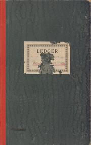
Document - BENDIGO BOYS TRAINING FARM LEDGER
Dark green covers, red spine. Ledger book of financial records of Boys' Training Farm 1935 - 1937. Payments to Bendigo businesses listed and financial costs of running aspects of the farm detailed. e.g. Wages - lads; piggery, fowl pens, implement shed, windmill ( pages 46 - 50)bendigo, institutions, boys' training farm, boys' training farm, j.t. keane, flora hill -
Bendigo Historical Society Inc.
Tool - INDIGENOUS STONE TOOL COLLECTION: GRINDING STONE
Dark brown grinding stone, found near Strathfieldsaye. Sticker on stone '4'. Interpretive sign used in early display of items reads ' Stone Age Implements, exhibits Nos. 1 - 5, found near Strathfieldsaye, Victoria. Used by the aborigines of the Campaspe area to grind the seeds of plants into flour' -
Tatura Irrigation & Wartime Camps Museum
Calendar, Rudolf Hofer and Rosa Hermann, 1946
Made by internees Rudolf Hofer and Rosa Hermann at Camp 3 Tatura.Fawn coloured cards on each of which are picture postcards. e.g. the month of July depicts a farmer walking behind a black and white horse pulling 2 wooden implements. Calendar dates and picture postcards on each side of card and held together by red tape, threaded through punched holes. rudolf hofer, rosa hermann, calendar, camp 3 tatura, internees -
 Melbourne Tram Museum
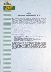
Document - Report, The Met, "MetTicket Tram Operations Employee Information (No. 2)", Late 1989
Report - 10 pages - stapled in the top left hand corner, titled "MetTicket Tram Operations Employee Information (No. 2)", giving a update on the details of the new scratch system, implementation, redeployment and retraining, operating procedures for one person trams and details of the new tickets and fares. Not dated, late 1989.trams, tramways, tickets, scratch tickets, the met, reports, tram drivers, drivers, one man trams -
Bendigo Historical Society Inc.
Tool - INDIGENOUS STONE TOOL COLLECTION: CUTTING, SCRAPING STONE
Dark grey cutting stone. Number '5' on stone. Stone is dome shaped with sharp, knapped end. Interpretive sign found with stone reads ' Stone age implements, exhibits Nos 1 - 5, found near Strathfieldsaye, Victoria. Used by the aborigines of the Campaspe area to grind the seeds of plants into a flour'first people, dja dja wurrung, bendigo, campaspe -
 Koroit & District Historical Society
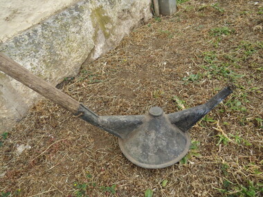
Tussock burner
This hand tool was used to reduce tussock grass by burning. It comprised of a long wooden handle with a wick and fuel container at one end. This kind of implement was used in the early 20th Century up until around the 1940s.The tussock burner is of local historical significance as an example of the kind of hand tools used during the period of early farming in the Koroit district. The significance is increased by its possible connection to Joseph Patrick Lee, farmer of Wangoom.The tussock burner is a long handled tool with a fuel burner at one end. farming implements, tussock, burner, tools, wangoom, st mary's farm -
 Kew Historical Society Inc
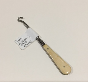
Functional object - Bone, Chrome & Steel Boutonneur, 1880-1920
A 'Boutonneur' or Buttoner; is an instrument wherewith buttons are pulled through their o'er-strait holes. To use the implement on a shoe, one firmly grasped the handle, and then inserted the steel hook through the eyelet, grasping the button and pulling it through.Small chrome plated steel hook with bone panels riveted to either side of the handle.footwear accessories, button hooks, boutonneurs, buttoners -
 Kew Historical Society Inc
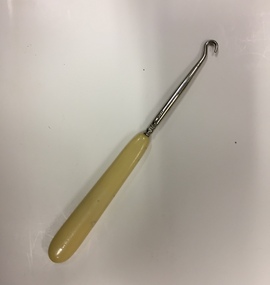
Functional object - Bone, Chrome & Steel Boutonneur, 1888-1914
A 'Boutonneur' or Buttoner; is an instrument wherewith buttons are pulled through their o'er-strait holes. To use the implement on a shoe, one firmly grasped the handle, and then inserted the steel hook through the eyelet, grasping the button and pulling it through.Bone and metal button hookfootwear accessories, button hooks, boutonneurs, buttoners -
 Kew Historical Society Inc
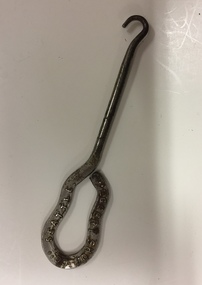
Functional object - Button Hook, L G Gert Shoe Company of Seattle, 1900s
A 'Boutonneur' or Buttoner; is an instrument wherewith buttons are pulled through their o'er-strait holes. To use the implement on a shoe, one firmly grasped the handle, and then inserted the steel hook through the eyelet, grasping the button and pulling it through.Metal Button hook made by or promoting what appears to be LG Gert Shoe Company of SeattleLG Gert Shoe Company of Seattlefootwear accessories, button hooks, boutonneurs, buttoners -
 Flagstaff Hill Maritime Museum and Village
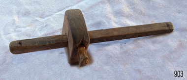
Tool - Marking Gauge, Believed to be homemade between 1900 to 1940s given no makers marks and the naivety of its construction
A marking gauge, also known as a scratch gauge, is used in woodworking and metalworking to mark out lines for cutting or other operations. The purpose of the gauge is to scribe a line parallel to a reference edge or surface. It is used in joinery and sheet metal work operations. The gauge consists of a beam, a headstock, and a scribing or marking implement, typically a pin, knife, pen or wheel. The headstock slides along the beam and is locked in place by various means: a locking screw, cam lever, or a wedge. The marking implement is fixed to one end of the beam. These types of gauges have been in use for many centuries and have not changed much in their design.An item that has not changed in use since its inception many hundreds of years ago. These types of marking gauges used by cabinet and joinery makers to mark or scribe their work for cutting are still produced and used today in many sizes by professional cabinet makers and individuals.Cabinet makers marking gauge, wooden, two adjustable staffs secured be a wedge through the block. Each staff has a metal nail in the end.Noneflagstaff hill, warrnambool, shipwrecked-coast, flagstaff-hill, flagstaff-hill-maritime-museum, maritime-museum, shipwreck-coast, flagstaff-hill-maritime-village -
 Flagstaff Hill Maritime Museum and Village
Tool - Marking Gauge, Believed to be homemade around the 1940s given no makers marks and the naivety of its construction
A marking gauge, also known as a scratch gauge, is used in woodworking and metalworking to mark out lines for cutting or other operations. The purpose of the gauge is to scribe a line parallel to a reference edge or surface. It is used in joinery and sheet metal work operations. The gauge consists of a beam, a headstock, and a scribing or marking implement, typically a pin, knife, pen or wheel. The headstock slides along the beam and is locked in place by various means: a locking screw, cam lever, or a wedge. The marking implement is fixed to one end of the beam. These types of gauges have been in use for many centuries and have not changed much in their design.An item that has not changed in use since its inception many hundreds of years ago. These types of marking gauges used by cabinet and joinery makers to mark or scribe their work for cutting are still produced and used today in many sizes by professional cabinet makers and individuals.Cabinet makers marking gauge, wooden, adjustable staff secured be a wedge through the block. Noneflagstaff hill, warrnambool, shipwrecked-coast, flagstaff-hill, flagstaff-hill-maritime-museum, maritime-museum, shipwreck-coast, flagstaff-hill-maritime-village, cabinet makers tools, woodworking tool, marking gauge, mortise gauge -
 Clunes Museum
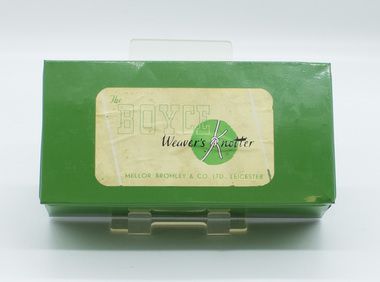
Tool - WEAVER'S KNOTTER, Mellor Bromley & Co. Ltd
Weaving Knotter used in Clunes Knitting Mill early 1900'sBoyce Weaver's Knotter Serial No. A22944 .1 Green rectangular tin to contain the apparatus .2 Knotter, metal implement attached to tan leather strapping with a metal circle with lever to position the knotter .3 Printed pamphlet for care and maintenance of the knotter .4 Instruction sheet .5 Printed pamphlet with operating instructionsboyce weaver's knotter, textile tool -
 Charlton Golden Grains Museum Inc
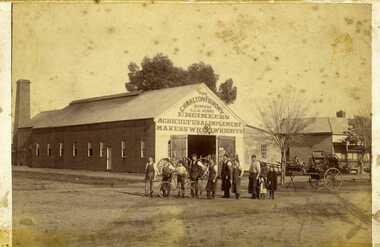
Photograph, Clarke Bros Photographers, The Charlton Foundry c. 1890, c.1890
Charlton Foundry building est 1885 corner of Learmonth and High Sts. Residence next door. Later Dabron's Foundry.Sepia photograph, mounted unframed of The Charlton Foundry Company, Late C.Munro, Engineers, Agricultural Implements Makers, Wheelwrights etc.. Ten people standing outside, seven men, a boy with a bicycle and two young girls. Long timber building with large chimney at the rear of the building, Machinery, wheels and horse drawn vehicles on display. Clark Bros Photographers 25 Thomas St Windsor. Charlton Foundry 1890foundry, munro's, charlton, charlton foundry -
 Vision Australia
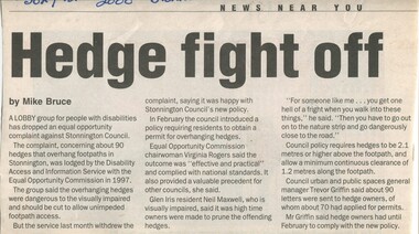
Article - Text, Hedge fight off by Mike Bruce
Newspaper article about complaints raised by a lobby group regarding 90 hedges that overhung footpaths and were dangerous for the vision impaired. Council implemented a new policy and the group dropped its equal opportunity complaint against Stonnington Council.1 newspaper article cut from a newspapernon-fictionelizabeth maxwell, neil maxwell, stonnington council, advocacy -
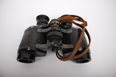 Dandenong/Cranbourne RSL Sub Branch
Equipment - Japanese Binoculars, Circa 1900s
This item was captured by H.Q. Coy, 2/14 Battalion at Balikpapan, Borneo 1945, probably by Tom Aldrick (given the inscription on the leather case). Tom Aldrick has donated other items taken from captured Japanese soldiers to the Dandenong-Cranbourne RSL.Black adjustable binoculars with brown leather strap and brown leather case with buckle strap. Case has blue/grey velvet lining and a leather belt strap. Clasp is missing. There is a Japanese inscription inside the case lid in black ink. Three Japanese characters are depicted. Adjacent to the right eyepiece there are also Japanese characters that have been inscribed into the surface with a sharp implement. Beige label adhered to front of case with "ALDRICK" handwritten in ink.binoculars, japanese binoculars, balikpapan, borneo, 1945 -
Port Melbourne Historical & Preservation Society
Poster, History of a Street Precinct
A cultural grant was given to Margaret BRIDE to implement this study, which she did with the help of her husband Graham and several residents of the study area including PMH&PS members Emily LOCK, David THOMPSON, Jack BOLT and Kerrie MATHEE.History of a Street Precinct, documenting 80 years plus of the history of the area bounded by Williamstown Road and Evans, Bridge and Farrell Streets, since 1880. One of two products of a 2005 project (which subsequently won the 2007 Victorian Local History Award for research). A brochure containing a map of the area and photos and information on key properties. An interactive CD (2148.02) containing information and photographs on 91 buildings and their occupants over time was also produced. built environment -
Port Melbourne Historical & Preservation Society
Mixed media, History of a Street Precinct
A cultural grant was given to Margaret BRIDE to implement this study, which she did with the help of her husband Graham and several residents of the study area including PMH&PS members Emily LOCK, David THOMPSON, Jack BOLT and Kerrie MATHEE.History of a Street Precinct, documenting 80 years plus of the history of the area bounded by Williamstown Road and Evans, Bridge and Farrell Streets, since 1880. One of two products of a 2005 project (which subsequently won the 2007 Victorian Local History Awards for research). An interactive CD containing information and photographs. This was packaged with a brochure (2148.01) containing a map of the area and photos and information on key properties and individuals on 91 buildings and their occupants over time.built environment -
 Kew Historical Society Inc
Map, MMBW, MMBW Town of Kew, 1910-21
The Melbourne and Metropolitan Board of Works (MMBW) was established by an act of the Victorian Parliament in 1890 to prepare for and to implement a sewerage and water reticulation system across what was then inner Melbourne, its surrounding and middle distance suburbs, including Kew. The MMBW was disbanded in 1991.The map collection of the Kew Historical Society has at its core the historic maps assembled and originally stored in the City Engineer's Department of the City of Kew. These include maps in a number of scales. The vast majority of maps were produced by the MMBW in the first two decades of the twentieth century, and are solid working maps, backed by linen for durability. These maps are historically significant to Kew, the City of Boroondara and to the history of the development of state utilities in Victoria. A number of the Kew maps have additional details added by former municipal officers, including the levels reached by various floods. As these were working documents, information was added to them long after the period of their initial production and distribution.Early map of the Town of Kew, created after 1910, at a scale 440 ft to 1 inch. The 'assembled' map by the City of Kew Engineer's Department includes scaled down copies of The Melbourne and Metropolitan Board of Works maps, Nos. 39, 40, 64, 65, 66, 67, 68, and 117. The map covers the entirety of the Town of Kew, bordered on its north and west by the River Yarra, by Burke Road in the East and Barkers Road in the south. The map shows the extent of urban development by that time, prominent institutions and the outlines of built structures in the municipality. TOWN OF KEW / SCALE 400 FEET TO 1 INCHmelbourne & metropolitan board of works, mmbw maps, mmbw plans, town of kew, cartography -
 Kew Historical Society Inc
Map, MMBW, MMBW Plan No.39 Kew & Heidelberg, 1900-1910
The Melbourne and Metropolitan Board of Works (MMBW) was established by an act of the Victorian Parliament in 1890 to prepare for and to implement a sewerage and water reticulation system across what was then inner Melbourne, its surrounding and middle distance suburbs, including Kew. The MMBW was disbanded in 1991.The map collection of the Kew Historical Society has at its core the historic maps assembled and originally stored in the City Engineer's Department of the City of Kew. These include maps in a number of scales. The vast majority of maps were produced by the MMBW in the first two decades of the twentieth century, and are solid working maps, backed by linen for durability. These maps are historically significant to Kew, the City of Boroondara and to the history of the development of state utilities in Victoria. A number of the Kew maps have additional details added by former municipal officers, including the levels reached by various floods. As these were working documents, information was added to them long after the period of their initial production and distribution.Early map of part of the Borough of Kew, created in the first decade of the twentieth century, at a scale 160 ft to 1 inch. The map covers what was then the north western section of Kew, bordered on its north by Wills Street and the Kew Lunatic Asylum, in the west by the River Yarra [and the later added Yarra Boulevard] , by Princess Street in the East and Holroyd Street in the south. The map shows the extent of urban development by that time, prominent institutions and the outlines of built structures in the municipality. Contour lines were added in ink to the map at a later stage.MELBOURNE AND METROPOLITAN BOARD OF WORKS / PLAN NO. 39 / KEW & HEIDELBERGmelbourne & metropolitan board of works, mmbw maps, mmbw plans, borough of kew, cartography