Showing 1133 items matching "kew east"
-
 Kew Historical Society Inc
Drawing - Property Illustration, Margaret Picken, 89 Kilby Road, Kew East, 1998
... 89 Kilby Road, Kew East...89 kilby road -- kew east (vic.)... Kilby Road, Kew East by Margaret Picken....- architectural drawings -- houses -- kew (vic.) 89 kilby road -- kew east ...After training as a Cartographic Draftsman within the mining industry, I worked as a property illustrator for real estate firms in the eastern suburbs of Melbourne for 23 years from 1983. I initially photographed houses with a Polaroid camera and made a 'thumbnail' sketch while there. The photos were used to scale off a sketch in pencil and then that sketch was overlaid with drafting film and the 'pen and ink' completed. The pens I used were the Rotring ‘Rapidigraph’ drafting pens. The ink was also made by Rotring (German).The film was ‘Rapidraw’, polyester drafting film, double matte. It takes a very fine line and doesn’t bleed. As well as house sketches, there were often floor plans and site plans ordered. Aerial sketches were ordered when the property needed an overall view. (Margaret Picken, 2020)This drawing is one of a series created by Margaret Picken for a number of real estate agents in Melbourne between 1983 and 2005. Each work is signed and dated by the artist.Gift of Margaret Picken, 2020Pen and ink architectural drawing on drafting film of 89 Kilby Road, Kew East by Margaret Picken.89 KILBY RD., KEW / MARGARET PICKEN '98 / WOODARDS ~ HAWTHORNartist -- margaret picken 1950-, architectural drawings -- houses -- kew (vic.), 89 kilby road -- kew east (vic.) -
 Kew Historical Society Inc
Drawing - Property Illustration, Margaret Picken, 99 Kilby Road, Kew East, 1987
... 99 Kilby Road, Kew East...99 kilby road -- kew east (vic.)... Kilby Road, Kew East by Margaret Picken....- architectural drawings -- houses -- kew (vic.) 99 kilby road -- kew east ...After training as a Cartographic Draftsman within the mining industry, I worked as a property illustrator for real estate firms in the eastern suburbs of Melbourne for 23 years from 1983. I initially photographed houses with a Polaroid camera and made a 'thumbnail' sketch while there. The photos were used to scale off a sketch in pencil and then that sketch was overlaid with drafting film and the 'pen and ink' completed. The pens I used were the Rotring ‘Rapidigraph’ drafting pens. The ink was also made by Rotring (German).The film was ‘Rapidraw’, polyester drafting film, double matte. It takes a very fine line and doesn’t bleed. As well as house sketches, there were often floor plans and site plans ordered. Aerial sketches were ordered when the property needed an overall view. (Margaret Picken, 2020)This drawing is one of a series created by Margaret Picken for a number of real estate agents in Melbourne between 1983 and 2005. Each work is signed and dated by the artist.Gift of Margaret Picken, 2020Pen and ink architectural drawing on drafting film of 99 Kilby Road, Kew East by Margaret Picken.99 KILBY RD., KEW/ MARGARET PICKEN '87 artist -- margaret picken 1950-, architectural drawings -- houses -- kew (vic.), 99 kilby road -- kew east (vic.) -
 Kew Historical Society Inc
Drawing - Property Illustration, Margaret Picken, 153 Kilby Road, Kew East, 1995
... 153 Kilby Road, Kew East...153 kilby road -- kew east (vic.)... Kilby Road, Kew East by Margaret Picken.... east (vic.) 153 KILBY RD., KEW / MARGARET PICKEN '95 / WOODARDS ...After training as a Cartographic Draftsman within the mining industry, I worked as a property illustrator for real estate firms in the eastern suburbs of Melbourne for 23 years from 1983. I initially photographed houses with a Polaroid camera and made a 'thumbnail' sketch while there. The photos were used to scale off a sketch in pencil and then that sketch was overlaid with drafting film and the 'pen and ink' completed. The pens I used were the Rotring ‘Rapidigraph’ drafting pens. The ink was also made by Rotring (German).The film was ‘Rapidraw’, polyester drafting film, double matte. It takes a very fine line and doesn’t bleed. As well as house sketches, there were often floor plans and site plans ordered. Aerial sketches were ordered when the property needed an overall view. (Margaret Picken, 2020)This drawing is one of a series created by Margaret Picken for a number of real estate agents in Melbourne between 1983 and 2005. Each work is signed and dated by the artist.Gift of Margaret Picken, 2020Pen and ink architectural drawing on drafting film of 153 Kilby Road, Kew East by Margaret Picken.153 KILBY RD., KEW / MARGARET PICKEN '95 / WOODARDS ~ KEWartist -- margaret picken 1950-, architectural drawings -- houses -- kew (vic.), 153 kilby road -- kew east (vic.) -
 Kew Historical Society Inc
Drawing - Property Illustration, Margaret Picken, 178 Kilby Road, Kew East, 1992
... 178 Kilby Road, Kew East...178 kilby road -- kew east (vic.)... Kilby Road, Kew East by Margaret Picken.... east (vic.) 178 KILBY RD., KEW / MARGARET PICKEN '92 / WOODARDS ...After training as a Cartographic Draftsman within the mining industry, I worked as a property illustrator for real estate firms in the eastern suburbs of Melbourne for 23 years from 1983. I initially photographed houses with a Polaroid camera and made a 'thumbnail' sketch while there. The photos were used to scale off a sketch in pencil and then that sketch was overlaid with drafting film and the 'pen and ink' completed. The pens I used were the Rotring ‘Rapidigraph’ drafting pens. The ink was also made by Rotring (German).The film was ‘Rapidraw’, polyester drafting film, double matte. It takes a very fine line and doesn’t bleed. As well as house sketches, there were often floor plans and site plans ordered. Aerial sketches were ordered when the property needed an overall view. (Margaret Picken, 2020)This drawing is one of a series created by Margaret Picken for a number of real estate agents in Melbourne between 1983 and 2005. Each work is signed and dated by the artist.Gift of Margaret Picken, 2020Pen and ink architectural drawing on drafting film of 178 Kilby Road, Kew East by Margaret Picken.178 KILBY RD., KEW / MARGARET PICKEN '92 / WOODARDS ~ KEWartist -- margaret picken 1950-, architectural drawings -- houses -- kew (vic.), 178 kilby road -- kew east (vic.) -
 Kew Historical Society Inc
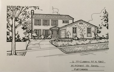
Drawing - Property Illustration, Margaret Picken, 6 McCubbin Street, Kew East, 2002
... 6 McCubbin Street, Kew East...6 mccubbin street -- kew east (vic.)... McCubbin Street, Kew East by Margaret Picken.... east (vic.) 6 McCUBBIN ST., E. KEW / M. PICKEN © 2002 ...After training as a Cartographic Draftsman within the mining industry, I worked as a property illustrator for real estate firms in the eastern suburbs of Melbourne for 23 years from 1983. I initially photographed houses with a Polaroid camera and made a 'thumbnail' sketch while there. The photos were used to scale off a sketch in pencil and then that sketch was overlaid with drafting film and the 'pen and ink' completed. The pens I used were the Rotring ‘Rapidigraph’ drafting pens. The ink was also made by Rotring (German).The film was ‘Rapidraw’, polyester drafting film, double matte. It takes a very fine line and doesn’t bleed. As well as house sketches, there were often floor plans and site plans ordered. Aerial sketches were ordered when the property needed an overall view. (Margaret Picken, 2020)This drawing is one of a series created by Margaret Picken for a number of real estate agents in Melbourne between 1983 and 2005. Each work is signed and dated by the artist.Gift of Margaret Picken, 2020Pen and ink architectural drawing on drafting film of 6 McCubbin Street, Kew East by Margaret Picken.6 McCUBBIN ST., E. KEW / M. PICKEN © 2002 / FLETCHERSartist -- margaret picken 1950-, architectural drawings -- houses -- kew (vic.), 6 mccubbin street -- kew east (vic.) -
 Kew Historical Society Inc
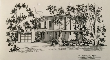
Drawing - Property Illustration, Margaret Picken, 27 Munro Street, Kew East, 1988
... 27 Munro Street, Kew East...27 munro street - kew east (vic)... Munro Street, Kew East by Margaret Picken.... east (vic) 27 MUNRO ST., KEW / MARGARET PICKEN '88 / WOODARDS ...After training as a Cartographic Draftsman within the mining industry, I worked as a property illustrator for real estate firms in the eastern suburbs of Melbourne for 23 years from 1983. I initially photographed houses with a Polaroid camera and made a 'thumbnail' sketch while there. The photos were used to scale off a sketch in pencil and then that sketch was overlaid with drafting film and the 'pen and ink' completed. The pens I used were the Rotring ‘Rapidigraph’ drafting pens. The ink was also made by Rotring (German).The film was ‘Rapidraw’, polyester drafting film, double matte. It takes a very fine line and doesn’t bleed. As well as house sketches, there were often floor plans and site plans ordered. Aerial sketches were ordered when the property needed an overall view. (Margaret Picken, 2020)This drawing is one of a series created by Margaret Picken for a number of real estate agents in Melbourne between 1983 and 2005. Each work is signed and dated by the artist.Gift of Margaret Picken, 2020Pen and ink architectural drawing on drafting film of 27 Munro Street, Kew East by Margaret Picken.27 MUNRO ST., KEW / MARGARET PICKEN '88 / WOODARDS ~ KEWartist -- margaret picken 1950-, architectural drawings -- houses -- kew (vic.), 27 munro street - kew east (vic) -
 Kew Historical Society Inc
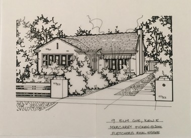
Drawing - Property Illustration, Margaret Picken, 9 Elm Grove, Kew East, 2001
... 9 Elm Grove, Kew East...9 elm grove -- kew east (vic.)... Grove, Kew East by Margaret Picken....- architectural drawings -- houses -- kew (vic.) 9 elm grove -- kew east ...This architectural drawing is one of a series created by Margaret Picken for a range of real estate agents in Melbourne between c.1983 and c.2005. Each work is signed and dated by the artist.Gift of Margaret Picken, 2020Pen and ink architectural drawing on drafting film of 9 Elm Grove, Kew East by Margaret Picken.9 ELM GVE., KEW E / MARGARET PICKEN (c) 2001 / FLETCHERS REAL ESTATEartist -- margaret picken 1950-, architectural drawings -- houses -- kew (vic.), 9 elm grove -- kew east (vic.) -
 Kew Historical Society Inc
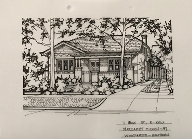
Drawing - Property Illustration, Margaret Picken, 11 Hale Street, Kew East, 1997
... 11 Hale Street, Kew East...11 hale street - kew east (vic).... Hale Street, Kew East by Margaret Picken....- architectural drawings -- houses -- kew (vic.) 11 hale street - kew east ...After training as a Cartographic Draftsman within the mining industry, I worked as a property illustrator for real estate firms in the eastern suburbs of Melbourne for 23 years from 1983. I initially photographed houses with a Polaroid camera and made a 'thumbnail' sketch while there. The photos were used to scale off a sketch in pencil and then that sketch was overlaid with drafting film and the 'pen and ink' completed. The pens I used were the Rotring ‘Rapidigraph’ drafting pens. The ink was also made by Rotring (German).The film was ‘Rapidraw’, polyester drafting film, double matte. It takes a very fine line and doesn’t bleed. As well as house sketches, there were often floor plans and site plans ordered. Aerial sketches were ordered when the property needed an overall view. (Margaret Picken, 2020)This drawing is one of a series created by Margaret Picken for a number of real estate agents in Melbourne between 1983 and 2005. Each work is signed and dated by the artist.Gift of Margaret Picken, 2020Pen and ink architectural drawing on drafting film of 11 Hale Street, Kew East by Margaret Picken.11 HALE ST., E. KEW / MARGARET PICKEN ~97 / WOODARDS ~ HAWTHORNartist -- margaret picken 1950-, architectural drawings -- houses -- kew (vic.), 11 hale street - kew east (vic). -
 Kew Historical Society Inc
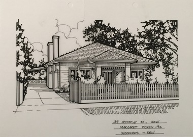
Drawing - Property Illustration, Margaret Picken, 39 Irymple Avenue, Kew East, 1992
... 39 Irymple Avenue, Kew East...39 irymple avenue -- kew east (vic.)... Irymple Street, Kew East by Margaret Picken.... east (vic.) 39 IRYMPLE RD., KEW / MARGARET PICKEN '92 ...After training as a Cartographic Draftsman within the mining industry, I worked as a property illustrator for real estate firms in the eastern suburbs of Melbourne for 23 years from 1983. I initially photographed houses with a Polaroid camera and made a 'thumbnail' sketch while there. The photos were used to scale off a sketch in pencil and then that sketch was overlaid with drafting film and the 'pen and ink' completed. The pens I used were the Rotring ‘Rapidigraph’ drafting pens. The ink was also made by Rotring (German).The film was ‘Rapidraw’, polyester drafting film, double matte. It takes a very fine line and doesn’t bleed. As well as house sketches, there were often floor plans and site plans ordered. Aerial sketches were ordered when the property needed an overall view. (Margaret Picken, 2020)This drawing is one of a series created by Margaret Picken for a number of real estate agents in Melbourne between 1983 and 2005. Each work is signed and dated by the artist.Gift of Margaret Picken, 2020Pen and ink architectural drawing on drafting film of 39 Irymple Street, Kew East by Margaret Picken.39 IRYMPLE RD., KEW / MARGARET PICKEN '92 / WOODARDS ~ KEWartist -- margaret picken 1950-, architectural drawings -- houses -- kew (vic.), 39 irymple avenue -- kew east (vic.) -
 Kew Historical Society Inc
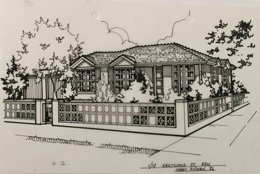
Drawing - Property Illustration, Margaret Picken, 1/18 Hartwood Street, Kew East, 1986
... 1/18 Hartwood Street, Kew East...1/18 hartwood street - kew east (vic).... Hartwood Street, Kew East by Margaret Picken.... - kew east (vic). 1/18 HARTWOOD ST., KEW / MARG. PICKEN '86 Pen ...After training as a Cartographic Draftsman within the mining industry, I worked as a property illustrator for real estate firms in the eastern suburbs of Melbourne for 23 years from 1983. I initially photographed houses with a Polaroid camera and made a 'thumbnail' sketch while there. The photos were used to scale off a sketch in pencil and then that sketch was overlaid with drafting film and the 'pen and ink' completed. The pens I used were the Rotring ‘Rapidigraph’ drafting pens. The ink was also made by Rotring (German).The film was ‘Rapidraw’, polyester drafting film, double matte. It takes a very fine line and doesn’t bleed. As well as house sketches, there were often floor plans and site plans ordered. Aerial sketches were ordered when the property needed an overall view. (Margaret Picken, 2020)This drawing is one of a series created by Margaret Picken for a number of real estate agents in Melbourne between 1983 and 2005. Each work is signed and dated by the artist.Gift of Margaret Picken, 2020Pen and ink architectural drawing on drafting film of 1/18 Hartwood Street, Kew East by Margaret Picken.1/18 HARTWOOD ST., KEW / MARG. PICKEN '86 artist -- margaret picken 1950-, architectural drawings -- houses -- kew (vic.), 1/18 hartwood street - kew east (vic). -
 Kew Historical Society Inc
Photograph, Country Roads Board, Hays Paddock, East Kew, 1975
... Hays Paddock, East Kew...hays paddock - kew east (vic)...Colour photograph of Hays Paddock in East Kew taken...Kew East, Greater Melbourne, Victoria, Australia... paddock - kew east (vic) parks and gardens - kew (vic) Reverse ...Colour photograph of Hays Paddock in East Kew taken by a Country Roads Board photographer. The reverse provides details of the negative and the purpose of the photograph.Reverse: "Hays Paddock. Tops of bank to be rounded gently, grassed & planted."hays paddock - kew east (vic), parks and gardens - kew (vic) -
 Kew Historical Society Inc
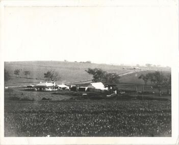
Photograph, Kilby Farm, Kew East
... Kilby Farm, Kew East...kew east...A panoramic photograph of Kilby (or Oswin's) Farm in East... farm kilby lodge william oswin dorothy rogers kew east "Kilby ...Kilby Lodge (c.1845-c.1922). William Oswin purchased Crown Land Lots 52 & 53 in 1845. These lots ran north from an old bullock track [later Kilby Road] to the Yarra, and east to Burke Road. Oswin purchased a neighbouring Lot in 1851, separated by the bullock track from the rest of the farm. Oswin built ‘Kilby Lodge’ and, with his brother, farmed dairy cattle on the site. Oswin’s descendants owned the farm into the 1890s. New subdivisions of Kilby and neighbouring farms in the 1920s changed the rural nature of north Kew. Housing and large recreation reserves replaced dairy farms and market gardens. This work forms part of the collection assembled by the historian Dorothy Rogers, that was donated to the Kew Historical Society by her son John Rogers in 2015. The manuscripts, photographs, maps, and documents were sourced by her from both family and local collections or produced as references for her print publications. Many were directly used by Rogers in writing ‘Lovely Old Homes of Kew’ (1961) and 'A History of Kew' (1973), or the numerous articles on local history that she produced for suburban newspapers. Most of the photographs in the collection include detailed annotations in her hand. The Rogers Collection provides a comprehensive insight into the working habits of a historian in the 1960s and 1970s. Together it forms the largest privately-donated collection within the archives of the Kew Historical Society.A panoramic photograph of Kilby (or Oswin's) Farm in East Kew."Kilby Farm when Oswins owned it. Commenced 1845."kilby farm, kilby lodge, william oswin, dorothy rogers, kew east -
 Kew Historical Society Inc
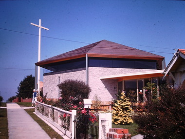
Photograph - St Paul's Church, Kew East, Ron Setford, 1961
... St Paul's Church, Kew East...St Paul's Church -- Kew East (Vic.)... Avenue, East Kew, from c.1946 to c.1995. A keen photographer, he... Avenue, East Kew, from c.1946 to c.1995. A keen photographer, he ...Ron Setford and his wife Grace Setford lived in Tanner Avenue, East Kew, from c.1946 to c.1995. A keen photographer, he recorded the changing face of Kew over a 20 year period. Apart from 30 photographs of built structures and places in Kew dating from 1960 and 1961, 145 of his 35mm colour slides chronicle the development of the Eastern Freeway through the Yarra Valley over a five year period from c.1972 to c.1977. This important collection was donated to the Society by his granddaughter in 2025.This collection of 175 35mm slides is of local and statewide significance, owing to its subject matter, particularly the major development of road transport infrastructure during the 1970s with the construction of the Eastern Freeway. The photographer also took care to annotate and date most of his slides which enable the researcher to pinpoint temporal and spatial locations.Nilron setford, photographs -- kew (vic.) -- 1960s, st paul's church -- kew east (vic.) -
 Kew Historical Society Inc
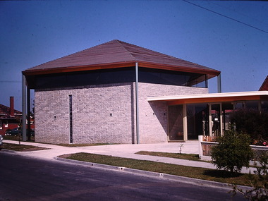
Photograph - St Paul's Church, Kew East, Ron Setford, 1961
... St Paul's Church, Kew East...St Paul's Church -- Kew East (Vic.)... Avenue, East Kew, from c.1946 to c.1995. A keen photographer, he... Avenue, East Kew, from c.1946 to c.1995. A keen photographer, he ...Ron Setford and his wife Grace Setford lived in Tanner Avenue, East Kew, from c.1946 to c.1995. A keen photographer, he recorded the changing face of Kew over a 20 year period. Apart from 30 photographs of built structures and places in Kew dating from 1960 and 1961, 145 of his 35mm colour slides chronicle the development of the Eastern Freeway through the Yarra Valley over a five year period from c.1972 to c.1977. This important collection was donated to the Society by his granddaughter in 2025.This collection of 175 35mm slides is of local and statewide significance, owing to its subject matter, particularly the major development of road transport infrastructure during the 1970s with the construction of the Eastern Freeway. The photographer also took care to annotate and date most of his slides which enable the researcher to pinpoint temporal and spatial locations.Nilron setford, photographs -- kew (vic.) -- 1960s, st paul's church -- kew east (vic.) -
 Kew Historical Society Inc
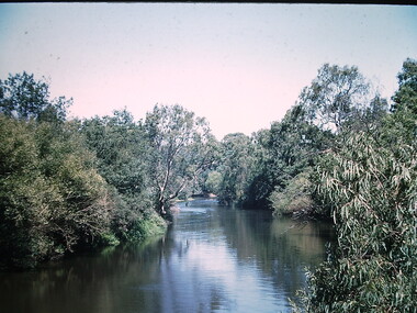
Photograph - Yarra River at Kew East, Ron Setford, 1960
... Yarra River at Kew East...Yarra River -- Kew East (Vic.)... Avenue, East Kew, from c.1946 to c.1995. A keen photographer, he... Avenue, East Kew, from c.1946 to c.1995. A keen photographer, he ...Ron Setford and his wife Grace Setford lived in Tanner Avenue, East Kew, from c.1946 to c.1995. A keen photographer, he recorded the changing face of Kew over a 20 year period. Apart from 30 photographs of built structures and places in Kew dating from 1960 and 1961, 145 of his 35mm colour slides chronicle the development of the Eastern Freeway through the Yarra Valley over a five year period from c.1972 to c.1977. This important collection was donated to the Society by his granddaughter in 2025.This collection of 175 35mm slides is of local and statewide significance, owing to its subject matter, particularly the major development of road transport infrastructure during the 1970s with the construction of the Eastern Freeway. The photographer also took care to annotate and date most of his slides which enable the researcher to pinpoint temporal and spatial locations.Nilron setford, photographs -- kew (vic.) -- 1960s, yarra river -- kew east (vic.) -
 Kew Historical Society Inc
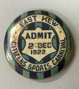
Badge - Fundraising Button, East Kew Citizens Sports Carnival, Admit 2nd December 1922, 1922
... East Kew Citizens Sports Carnival, Admit 2nd December 1922...east kew... including two associated with the East Kew Citizens Sports Carnival...A circular button produced for the East Kew Citizens Sports..."East Kew Citizens Sports Carnival, Admit 2nd December 1922"... with the East Kew Citizens Sports Carnival. The subdivision of the area ...Most of the ephemera assembled by Francis Rigg were patriotic buttons but also included come sporting event buttons including two associated with the East Kew Citizens Sports Carnival. The subdivision of the area now known as Kew East commenced before World War 1, but it was not until the 1920s that it became fully developed. At this time, there was a strong Progress Association and this body raised funds to purchase land and build the East Kew Citizen’s Hall in Normandy Road, the first stage of which was completed in 1922. This hall was designed to be extended, although this never occurred, and the building now forms part of the facilities of the East Kew Uniting Church. The ‘East Kew Citizens Sports Carnival’ may well have been a fundraiser event for the building fund. As far as is known, the carnival was only held for a couple of years.Frances Rigg was a local business identity in Kew, at one stage managing the local branch of the English, Scottish and Australian (ES&A) Bank at 175 High Street from c. 1920 until the 1940s. After Francis Rigg’s death, the collection of buttons and medallions was inherited by his son, Ken Rigg (1922-2014). The collection was subsequently donated to the Kew Historical Society in 2015 by Francis' grandson, Adrian Rigg, at the time of the Gallipoli & Beyond Commemoration in 2015. The collection covers a period of almost 40 years. The majority of the buttons are patriotic buttons, issued and sold during and immediately after the First World World War (1914-1918) to raise funds for national and overseas causes. The collection also includes a number of locally significant sporting event buttons and sporting club medallions, issued in the 1920s and 1930s.A circular button produced for the East Kew Citizens Sports Carnival in 1922. The button has a ground of vertical stripes in shades of blue. The name of the event is within a white circular band. A white shield in the centre that includes the words “Admit” would indicate that the badge was purchased and worn on the day of the carnival to indicate that the wearer had paid the admission fee. "East Kew Citizens Sports Carnival, Admit 2nd December 1922"east kew, east kew citizens sports carnival, sports, badge, numismatics, francis rigg -
 Kew Historical Society Inc
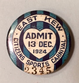
Badge - Fundraising Button, East Kew Citizens Sports Carnival: Admit 13 Dec. 1924, 1924
... East Kew Citizens Sports Carnival: Admit 13 Dec. 1924...kew east... including two associated with the East Kew Citizens Sports Carnival...A circular badge produced for the East Kew Citizens Sports..."East Kew Citizens Sports Carnival / Admit 13 Dec. 1924"... with the East Kew Citizens Sports Carnival. The subdivision of the area ...Most of the ephemera assembled by Francis Rigg were patriotic buttons but also included come sporting event buttons including two associated with the East Kew Citizens Sports Carnival. The subdivision of the area now known as Kew East commenced before World War 1, but it was not until the 1920s that it became fully developed. At this time, there was a strong Progress Association and this body raised funds to purchase land and build the East Kew Citizen’s Hall in Normandy Road, the first stage of which was completed in 1922. This hall was designed to be extended, although this never occurred, and the building now forms part of the facilities of the East Kew Uniting Church. The ‘East Kew Citizens Sports Carnival’ may well have been a fundraiser event for the building fund. As far as is known, the carnival was only held for a couple of years.Frances Rigg was a local business identity in Kew, at one stage managing the local branch of the English, Scottish and Australian (ES&A) Bank at 175 High Street from c. 1920 until the 1940s. After Francis Rigg’s death, the collection of buttons and medallions was inherited by his son, Ken Rigg (1922-2014). The collection was subsequently donated to the Kew Historical Society in 2015 by Francis' grandson, Adrian Rigg, at the time of the Gallipoli & Beyond Commemoration in 2015. The collection covers a period of almost 40 years. The majority of the buttons are patriotic buttons, issued and sold during and immediately after the First World World War (1914-1918) to raise funds for national and overseas causes. The collection also includes a number of locally significant sporting event buttons and sporting club medallions, issued in the 1920s and 1930s.A circular badge produced for the East Kew Citizens Sports Carnival in 1924. The badge has a ground of vertical stripes in shades of blue. The name of the event is within a white circular band. A white shield in the centre includes the words “Admit” which would indicate that the badge was purchased and worn on the day of the carnival to indicate that the wearer had paid the admission fee."East Kew Citizens Sports Carnival / Admit 13 Dec. 1924"kew east, sport buttons -
 Kew Historical Society Inc
Photograph - Yarra Valley Floods: Kew East, 1916
... Yarra Valley Floods: Kew East... of the Yarra bordering Kew and Kew East in the north and west...Flooding of the Yarra Valley at East Kew in 1916. The view...Verso: "Floods / Yarra River / East Kew / Kilby Road / 1917... bordering Kew and Kew East in the north and west of the municipality ...Flooding of the Yarra Valley, including that section of the Yarra bordering Kew and Kew East in the north and west of the municipality, was a regular occurrence. Extreme flood events of the Yarra River are recorded to have occurred in 1891, 1901, 1916, 1923 and 1934. The Municipality of Kew's response to these floods was to enact planning decisions restricting residential development in flood prone areas following the floods of 1916, 1921 and 1934. While floods continued after the development of the Upper Yarra Reservoir (construction 1948-57), the regularity and extent of these inundations diminished. During the nineteenth century, the land abutting the south side of the Yarra in Kew was devoted to dairy farming. In the twentieth century, before and after the construction of the Eastern Freeway, much of this low-lying area was used as golf courses and public parks.One of a collection of photographs of flooding in the Kew section of the Yarra Valley which are in important research resource for the location and extent of flooding in the first half of the twentieth century. Flooding of the Yarra Valley at East Kew in 1916. The view is taken from a street (maybe Birdwood Avenue) intersecting with Kilby Road looking northeast across the flood waters to Ivanhoe and Heidelberg. The extensive flooded area shown in the photograph would have included remnant dairy farms and the Kew Golf Club. Verso: "Floods / Yarra River / East Kew / Kilby Road / 1917? / 87"yarra river, yarra valley, floods -- kew, kilby road -- kew (vic.), kew golf club -
 Kew Historical Society Inc
Drawing - Property Illustration, Margaret Picken, 827 High Street, Kew East, 2002
... 827 High Street, Kew East...827 high street - kew east (vic).... High Street, East Kew by Margaret Picken.... film of 827 High Street, East Kew by Margaret Picken. 827 High ...After training as a Cartographic Draftsman within the mining industry, I worked as a property illustrator for real estate firms in the eastern suburbs of Melbourne for 23 years from 1983. I initially photographed houses with a Polaroid camera and made a 'thumbnail' sketch while there. The photos were used to scale off a sketch in pencil and then that sketch was overlaid with drafting film and the 'pen and ink' completed. The pens I used were the Rotring ‘Rapidigraph’ drafting pens. The ink was also made by Rotring (German).The film was ‘Rapidraw’, polyester drafting film, double matte. It takes a very fine line and doesn’t bleed. As well as house sketches, there were often floor plans and site plans ordered. Aerial sketches were ordered when the property needed an overall view. (Margaret Picken, 2020)This drawing is one of a series created by Margaret Picken for a number of real estate agents in Melbourne between 1983 and 2005. Each work is signed and dated by the artist.Gift of Margaret Picken, 2020Pen and ink architectural drawing on drafting film of 827 High Street, East Kew by Margaret Picken.827 HIGH ST., E.KEW / MARGARET PICKEN © 2002 / FLETCHERS REAL ESTATEartist -- margaret picken 1950-, architectural drawings -- houses -- kew (vic.), 827 high street - kew east (vic). -
![EJ Harvey, Motor Engineers, High Street [Kew East], circa 1925](/media/collectors/550653872162f11fb04854aa/items/586f9929d0ce2607f0b81f1a/item-media/586f99e0d0ce2607f0b8546f/item-fit-380x285.jpg) Kew Historical Society Inc
Kew Historical Society IncPhotograph - Photograph [copy], EJ Harvey, Motor Engineers, High Street [Kew East], circa 1925, c. 1925
... EJ Harvey, Motor Engineers, High Street [Kew East], circa...The building was in High Street, Kew East between Clyde..., East Kew. The garage was on the corner of Clyde Street....Inscription reverse: "High Street, East Kew - present site... The building was in High Street, Kew East between Clyde and Oswin ...The building was in High Street, Kew East between Clyde and Oswin Streets. The site is currently (2017) occupied by a canoe retailer.Rare and historic photograph of an early business in the Harp Village shopping precinctGarage - E.J. Harvey, Motor Engineers workshop, High Street, East Kew. The garage was on the corner of Clyde Street.Inscription reverse: "High Street, East Kew - present site of Harvey Phillips Retro Vision[*] shop. Gift of Edna Phillips. Edna loaned KHS the original photo and KHS had it copied." * Note - Harvey Phillips Retravision not Retro Vision].motor engineers (kew), garages (kew), e.j. harvey -
 Kew Historical Society Inc
Administrative record, East Kew Women's Club, Attendance Register, 1967-1971
... east kew women's club...The East Kew Women’s Club was formed on 20 July 1945...Register, East Kew Women’s Club, 1967-71...East Kew Women's Club... The East Kew Women’s Club was formed on 20 July 1945 ...The East Kew Women’s Club was formed on 20 July 1945 as an experiment amongst local women, who felt that there was a need for some organised group to give full scope to their various interests and hobbies. In the beginning, they met at the house of their founder, Mrs Eric Thake, 48 Harp Road, East Kew, but the growth and interest was so rapid that it was soon necessary to find a larger meeting place, so the group moved to the Harrier’s Pavilion in Victoria Park, Kew. At the fifth meeting of the group, a committee was formed, and a constitution adopted on 4 December 1945.The Club was aimed to be non-political, non-sectarian and open to women from any locality. The Club’s motto was “To Help others, Improve Ourselves, and Foster the Community Spirit”. The first twenty years of the Club was recorded in a small, nine-page publication “East Kew Women’s Club : Twenty Years 20-7-1945 - 30-7-1965”. Following the closure of the Club in 1973, after twenty-eight years, its records were deposited with the Kew Historical Society and are thus available for research into the history of women’s groups in the post war period in Australia. The Society holds the Club’s Minute Books of Meetings (1953-73), Attendance Registers (1959-73), Visitors Book, and sundry items of print ephemera published by the Club.Register, East Kew Women’s Club, 1967-71east kew women's club, community groups -- kew east (vic.) -
 Kew Historical Society Inc
Photograph - Photographs, Former Baptist Church, Woodlands Avenue, Kew East, 2018, 2018
... Former Baptist Church, Woodlands Avenue, Kew East, 2018... of the Kew East Heritage Gap Study. W D Vaughan in his 'Kew's Civic... in Woodlands Avenue, Kew East. The photographs are of the front... The former Baptist Church, at 8-12 Woodlands Avenue, Kew East ...The former Baptist Church, at 8-12 Woodlands Avenue, Kew East, was nominated by the Society for protection as part of the Kew East Heritage Gap Study. W D Vaughan in his 'Kew's Civic History' (1960 writes that: "With the development of East Kew, local Baptists considered the establishment of a church was necessary. A block of land was purchased in Woodlands Avenue and the foundation stone of a new church was laid on August 8, 1931. A fine Sunday school has since been erected, and special emphasis has been given to providing activities for the young people of the church"Three colour photographs of the former Baptist Church in Woodlands Avenue, Kew East. The photographs are of the front and side of the clinker brick building. One of the photographs shows the foundation stone, laid by AH Lewis Esq, 8 August 1931.churches - kew (vic), baptist church - woodlands avenue - kew (vic) -
 Kew Historical Society Inc
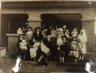
Photograph, East Kew Baby Health Centre, 1920s
... East Kew Baby Health Centre...kew east.... The building is located in Windella Avenue, Kew East and is still...Reverse: "East Kew Baby Health Centre". ... in Windella Avenue, Kew East and is still extant. The photo is taken ...Most likely the original photo was taken at or around the time of the official opening of the baby health centre. The building is located in Windella Avenue, Kew East and is still extant. The photo is taken in front of the front verandah of the building. This print is on Kodak photo paper, likely printed circa 1978. The East Kew Baby Health Centre was the first such centre built in the former City of Kew, and one of the first in Victoria. Few photos of the building at the time of its establishment are known. Reproduction print of black and white photograph of group of mothers and their babies, with nurse, in front of health centre.Reverse: "East Kew Baby Health Centre". kew east, baby health centre, windella avenue, maternal health, nursing -
 Kew Historical Society Inc
Plan - Subdivision Plan, Flower Farm Estate, East Kew, 1922
... Flower Farm Estate, East Kew...subdivision plans - east kew...The subdivision called the ‘Flower Farm Estate’ in Kew East... of the City of Melbourne. Most of these are of Kew, Kew East ...Pru Sanderson, in her groundbreaking ‘City of Kew Urban Conservation Study : Volume 2 - Development History’ (1988), summarised the periods of urban development and subdivisions of land in Kew. The periods that she identified included 1845-1880, 1880-1893, 1893-1921, 1921-1933, 1933-1943, and Post-War Development. These periods were selected as they represented periods of rapid growth or decline in urban development. An obvious starting point for Sanderson’s groupings involved population growth and the associated economic cycles. These cycles also highlighted urban expansion onto land that was predominantly rural, although in other cases it represented the decline and breakup of large estates. A number of the plans in the Kew Historical Society’s collection can also be found in other collections, such as those of the State Library of Victoria and the Boroondara Library Service. A number are however unique to the collection.The Kew Historical Society collection includes almost 100 subdivision plans pertaining to suburbs of the City of Melbourne. Most of these are of Kew, Kew East or Studley Park, although a smaller number are plans of Camberwell, Deepdene, Balwyn and Hawthorn. It is believed that the majority of the plans were gifted to the Society by persons connected with the real estate firm - J. R. Mathers and McMillan, 136 Cotham Road, Kew. The Plans in the collection are rarely in pristine form, being working plans on which the agent would write notes and record lots sold and the prices of these. The subdivision plans are historically significant examples of the growth of urban Melbourne from the beginning of the 20th Century up until the 1980s. A number of the plans are double-sided and often include a photograph on the reverse. The subdivision called the ‘Flower Farm Estate’ in Kew East occurred in 1922. It included 61 lots on either side of Boorool Road between High Street and Harp Road. In an advertisement in The Argus in the same year, the proximity of the estate to the newly erected shops at the corner of Harp Road and High Street is noted. The Flower Farm Estate and similar subdivisions in Kew East were assisted by the extension of the High Street tramline in 1924.subdivision plans - east kew, flower farm estate, high street - kew east (vic.), boorool road -- kew east (vic.), harp road -- kew east (vic.) -
 Kew Historical Society Inc
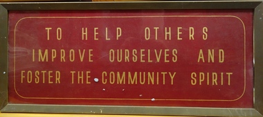
Plaque, East Kew Women's Club, To Help Others - Improve Ourselves And - Foster The Community Spirit, 1947
... east kew women's social club... club: the East Kew Women’s Community Club. The article reads...Framed red and gold enamelled plaque belonging to the East...East Kew Women's Club... club: the East Kew Women’s Community Club. The article reads ...On Saturday 17 May 1947, an article on page 25 of the Australian Women’s Weekly reported on the formation of a new women's club: the East Kew Women’s Community Club. The article reads: "Wives and mothers in a Melbourne suburb, East Kew, have formed the East Kew Women's Community Club. While babies and young children are under the supervision of a play leader, wives and mothers follow up their own interests. The club caters for varying tastes, has musical appreciation, drama, and "Keep Fit" classes. President Mrs. Grace Thake says that the club hopes soon to have tennis, debating, and discussion groups. The club originated from a debate, "Should women take an active part in social and civic affairs?" Two days later their interest in these matters was proved by the forming of the club, which took for its motto: "To help others, improve ourselves, and foster the community spirit." Membership is open to all women, regardless of age, politics, and religion, and aims to co-operate with all societies working for the improvement of health and cultural standards." The article relates particularly to the plaque in the collection of the Kew Historical Society.The East Kew Women's Community Club, also called the East Kew Women's Community Club functioned from c. 1947 to the end of the 1960s (to be verified). The records of the Club were placed with Kew Historical Society to preserve them for posterity. The records and objects belonging to the East Kew Women's Community Club have significance socially for their capacity to illuminate women's associations in the post war period in Australia.Framed red and gold enamelled plaque belonging to the East Kew Women's Community Club."TO HELP OTHERS / IMPROVE OURSELVES AND / FOSTER THE COMMUNITY SPIRIT"east kew women's social club, community groups -- kew east (vic.) -
 Kew Historical Society Inc
Photograph - Flooding of the Yarra Valley at Kew East, 1974
... Flooding of the Yarra Valley at Kew East... of the Yarra bordering Kew and Kew East in the north and west... land at East Kew under floodwater on 16 May 1974... bordering Kew and Kew East in the north and west of the municipality ...Flooding of the Yarra Valley, including that section of the Yarra bordering Kew and Kew East in the north and west of the municipality, was a regular occurrence. Extreme flood events of the Yarra River are recorded to have occurred in 1891, 1901, 1916, 1923 and 1934. The Municipality of Kew's response to these floods was to enact planning decisions restricting residential development in flood prone areas following the floods of 1916, 1921 and 1934. While floods continued after the development of the Upper Yarra Reservoir (construction 1948-57), the regularity and extent of these inundations diminished. During the nineteenth century, the land abutting the south side of the Yarra in Kew was devoted to dairy farming. In the twentieth century, before and after the construction of the Eastern Freeway, much of this low-lying area was used as golf courses and public parks.Late example of the capacity of the Yarra Valley at Kew to flood, even though drainage works and the Upper Yarra Reservoir had reduced their regularity.Original black and white print photograph of the low-lying land at East Kew under floodwater on 16 May 1974. The photograph is of Hyde Park looking north-east.Annotation verso: "Hyde Park looking nth-east / Flood Level / 16 May 1974 11.15am / R.L. 46.61"floods, yarra river, hyde park -
 Kew Historical Society Inc
Photograph - Flooding of the Yarra Valley at Kew East, 1974
... Flooding of the Yarra Valley at Kew East... of the Yarra bordering Kew and Kew East in the north and west... land at East Kew under floodwater on 16 May 1974. The vantage... bordering Kew and Kew East in the north and west of the municipality ...Flooding of the Yarra Valley, including that section of the Yarra bordering Kew and Kew East in the north and west of the municipality, was a regular occurrence. Extreme flood events of the Yarra River are recorded to have occurred in 1891, 1901, 1916, 1923 and 1934. The Municipality of Kew's response to these floods was to enact planning decisions restricting residential development in flood prone areas following the floods of 1916, 1921 and 1934. While floods continued after the development of the Upper Yarra Reservoir (construction 1948-57), the regularity and extent of these inundations diminished. During the nineteenth century, the land abutting the south side of the Yarra in Kew was devoted to dairy farming. In the twentieth century, before and after the construction of the Eastern Freeway, much of this low-lying area was used as golf courses and public parks.Late example of the capacity of the Yarra Valley at Kew to flood, even though drainage works and the Upper Yarra Reservoir had reduced their regularity.Original black and white print photograph of the low-lying land at East Kew under floodwater on 16 May 1974. The vantage point of the photographer is at Willsmere Road. The road itself is underwater.Annotation verso: "Willsmere Rd / Same as No.7 / 16 May 1974 11.15am"floods, yarra river, willsmere road -
 Kew Historical Society Inc
Document, Summary History of the East Kew Women's Club, 1970s
... Summary History of the East Kew Women's Club...east kew women's club...The East Kew Women’s Club was formed on 20 July 1945...1-page summary of the history of the East Kew Women's Club... The East Kew Women’s Club was formed on 20 July 1945 ...The East Kew Women’s Club was formed on 20 July 1945 as an experiment amongst local women, who felt that there was a need for some organised group to give full scope to their various interests and hobbies. In the beginning, they met at the house of their founder, Mrs Eric Thake, 48 Harp Road, East Kew, but the growth and interest was so rapid that it was soon necessary to find a larger meeting place, so the group moved to the Harrier’s Pavilion in Victoria Park, Kew. At the fifth meeting of the group, a committee was formed, and a constitution adopted on 4 December 1945.The Club was aimed to be non-political, non-sectarian and open to women from any locality. The Club’s motto was “To Help others, Improve Ourselves, and Foster the Community Spirit”. The first twenty years of the Club was recorded in a small, nine-page publication “East Kew Women’s Club : Twenty Years 20-7-1945 - 30-7-1965”. Following the closure of the Club in 1973, after twenty-eight years, its records were deposited with the Kew Historical Society and are thus available for research into the history of women’s groups in the post war period in Australia. The Society holds the Club’s Minute Books of Meetings (1953-73), Attendance Registers (1959-73), Visitors Book, and sundry items of print ephemera published by the Club.1-page summary of the history of the East Kew Women's Club. Undated with no author name.east kew women's club, community groups -- kew east (vic.) -
![Harp Junction [Kew East]](/media/collectors/550653872162f11fb04854aa/items/58cf094bd0ce9809d8715cf3/item-media/58cf59d0d0ce5d331467358d/item-fit-380x285.jpg) Kew Historical Society Inc
Kew Historical Society IncPhotograph, Harp Junction [Kew East], 1910-1930
... Harp Junction [Kew East]...The Harp Junction, East Kew....Annotation on reverse: "East Kew - looking towards city...) high street (kew) Annotation on reverse: "East Kew - looking ...Kew Junction at this stage was a tram terminusThe Harp Junction, East Kew.Annotation on reverse: "East Kew - looking towards city from harp of Erin Hotel - note wooden fence."harp of erin hotel (kew), high street (kew) -
 Kew Historical Society Inc
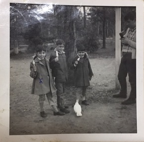
Photograph, East Kew Women's Club, Marlene Higgins, 1950s
... east kew women's club...The East Kew Women’s Club was formed on 20 July 1945..., an Aboriginal girl who was sponsored by the East Kew Women's Club...East Kew Women's Club... The East Kew Women’s Club was formed on 20 July 1945 ...The East Kew Women’s Club was formed on 20 July 1945 as an experiment amongst local women, who felt that there was a need for some organised group to give full scope to their various interests and hobbies. In the beginning, they met at the house of their founder, Mrs Eric Thake, 48 Harp Road, East Kew, but the growth and interest was so rapid that it was soon necessary to find a larger meeting place, so the group moved to the Harrier’s Pavilion in Victoria Park, Kew. At the fifth meeting of the group, a committee was formed, and a constitution adopted on 4 December 1945.The Club was aimed to be non-political, non-sectarian and open to women from any locality. The Club’s motto was “To Help others, Improve Ourselves, and Foster the Community Spirit”. The first twenty years of the Club was recorded in a small, nine-page publication “East Kew Women’s Club : Twenty Years 20-7-1945 - 30-7-1965”. Following the closure of the Club in 1973, after twenty-eight years, its records were deposited with the Kew Historical Society and are thus available for research into the history of women’s groups in the post war period in Australia. The Society holds the Club’s Minute Books of Meetings (1953-73), Attendance Registers (1959-73), Visitors Book, and sundry items of print ephemera published by the Club.Black and white photograph of Marlene Higgins, an Aboriginal girl who was sponsored by the East Kew Women's Club. The photograph is stuck into one of their registers.east kew women's club, community organisations -- kew east (vic.), aboriginal and torres straight islander