Showing 201 items
matching land conservation
-
 Wooragee Landcare Group
Photograph, 20th June 2004
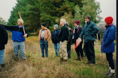
... and conservation among other considerations. The planting must ...Photo shows (L-R) Bob Dunnett; Tony Prowse; Mary Prowse; Ray Henderson; unknown; Lesley Finedon; unknown; unknown assessing successful stream side rehabilitation at Bev DeJong and Bob Dunnett's place during a paddock demonstration and tree planting field day, called 'Really Successful Tree Planting!' run by Wooragee Landcare on Sunday 20th June 2004. Maintaining and reforesting native trees, shrubs and grasses are really important for a variety of reasons, including creating native habitat and food for birds and other animals, shade, biodiversity, visual appeal, cooling, shade for urban areas, sequestering carbon and conservation among other considerations. The planting must be consistent with the particular needs of the environment, such as trees or shrubs which would naturally occur and are native to the area. Tree planting demonstrations such as this one run by the Landcare Group ensures that the projects are being managed consistently with an overarching commitment to land protection and management and the best methods for best outcomes are employed. This photograph is significant as it provides evidence of a project undertaken by the Wooragee Landcare Group to educate themselves and members of the public on successful techniques needed to plant and maintain trees for replanting in the Wooragee area. The Wooragee Landcare Group has been instrumental in the co-ordination of programs relating to biodiversity protection in the local area, providing great assistance to landholders.Landscape coloured photograph printed on gloss paperReverse: WAN NA 0ANA2N0 NNN+ 1 1636 / [PRINTED] (No.19) / 933wooragee landcare, wooragee landcare group, beechworth, landcare group, wooragee, tree planting, successful tree planting, demonstration, paddock demonstration, tree planting field day, really successful tree planting, land protection and management, land management, native trees, conservation -
 Wooragee Landcare Group
Photograph, 20th June 2004
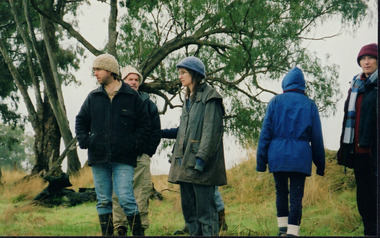
... and conservation among other considerations. The planting must ...Photo shows, (L-R): Lesley Finedon; unknown; Mary Prowse; Ann Henderson; Ray Henderson; Luke Bayley (North East CMA), assessing successful stream side rehabilitation at Bev DeJong and Bob Dunnett's place during a paddock demonstration and tree planting field day, called 'Really Successful Tree Planting!' run by Wooragee Landcare on Sunday 20th June 2004. Maintaining and reforesting native trees, shrubs and grasses are really important for a variety of reasons, including creating native habitat and food for birds and other animals, shade, biodiversity, visual appeal, cooling, shade for urban areas, sequestering carbon and conservation among other considerations. The planting must be consistent with the particular needs of the environment, such as trees or shrubs which would naturally occur and are native to the area. Tree planting demonstrations such as this one run by the Landcare Group ensures that the projects are being managed consistently with an overarching commitment to land protection and management and the best methods for best outcomes are employed.This photograph is significant as it provides evidence of a project undertaken by the Wooragee Landcare Group to educate themselves and members of the public on successful techniques needed to plant and maintain trees for replanting in the Wooragee area. The Wooragee Landcare Group has been instrumental in the co-ordination of programs relating to biodiversity protection in the local area, providing great assistance to landholders.WAN NA 0ANAON0 ANN+ 1 1636 / [PRINTED] (No.20) / 934wooragee landcare, wooragee landcare group, beechworth, landcare group, wooragee, tree planting, successful tree planting, demonstration, paddock demonstration, tree planting field day, really successful tree planting, land protection and management, land management, native trees, conservation -
 Wooragee Landcare Group
Photograph, 20th June 2004
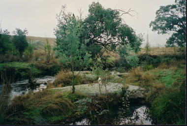
... , sequestering carbon and conservation among other considerations ...Photo of streamside planting and rehabilitation at Bev DeJong and Bob Dunnett's place during a paddock demonstration and tree planting field day, called 'Really Successful Tree Planting!' run by Wooragee Landcare on Sunday 20th June 2004. Maintaining and reforesting native trees, shrubs and grasses are really important for a variety of reasons, including creating native habitat and food for birds and other animals, shade, biodiversity, visual appeal, cooling, shade for urban areas, sequestering carbon and conservation among other considerations. The planting must be consistent with the particular needs of the environment, such as trees or shrubs which would naturally occur and are native to the area. Tree planting demonstrations such as this one run by the Landcare Group ensures that the projects are being managed consistently with an overarching commitment to land protection and management and the best methods for best outcomes are employed.This photograph is significant as it provides evidence of a project undertaken by the Wooragee Landcare Group to educate themselves and members of the public on successful techniques needed to plant and maintain trees for replanting in the Wooragee area. The Wooragee Landcare Group has been instrumental in the co-ordination of programs relating to biodiversity protection in the local area, providing great assistance to landholders.Landscape coloured photograph printed on gloss paperReverse: WAN NA 0ANA2N0 AN1 0 1636 / [PRINTED] (No.25) / 938wooragee landcare, wooragee landcare group, beechworth, landcare group, wooragee, tree planting, successful tree planting, demonstration, paddock demonstration, tree planting field day, really successful tree planting, land protection and management, land management, native trees, conservation, streamside, streamside planting -
 Wooragee Landcare Group
Photograph, 20 June 2004
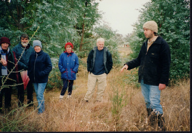
... and conservation among other considerations. The planting must ...Photo shows, (L-R): Luke Bayley; Ray Henderson; Chris Robinson; Ann Henderson; Lesley Finedon, assessing successful stream side rehabilitation at Bev DeJong and Bob Dunnett's place during a paddock demonstration and tree planting field day, called 'Really Successful Tree Planting!' run by Wooragee Landcare on Sunday 20th June 2004. Maintaining and reforesting native trees, shrubs and grasses are really important for a variety of reasons, including creating native habitat and food for birds and other animals, shade, biodiversity, visual appeal, cooling, shade for urban areas, sequestering carbon and conservation among other considerations. The planting must be consistent with the particular needs of the environment, such as trees or shrubs which would naturally occur and are native to the area. Tree planting demonstrations such as this one run by the Landcare Group ensures that the projects are being managed consistently with an overarching commitment to land protection and management and the best methods for best outcomes are employed.This photograph is significant as it provides evidence of a project undertaken by the Wooragee Landcare Group to educate themselves and members of the public on successful techniques needed to plant and maintain trees for replanting in the Wooragee area. The Wooragee Landcare Group has been instrumental in the co-ordination of programs relating to biodiversity protection in the local area, providing great assistance to landholders.Landscape coloured photograph printed on gloss paper.Reverse: WAN NA 0ANA2N0 NNN-1 1636/ [PRINTED] (No.23)/936/wooragee landcare, wooragee landcare group, beechworth, landcare group, wooragee, tree planting, successful tree planting, demonstration, paddock demonstration, tree planting field day, really successful tree planting, land protection and management, land management, native trees, conservation -
 Working Heritage Crown Land Collection
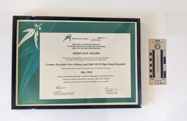
Award - former Drysdale Free Library Heritage Award, Former Drysdale Free Library and Hall 18-20 High Street Drysdale
Framed AwardNational Trust, City of Greater Geelong, Geelong and Regional Branch National Trust of Australia (Victoria) and City of Greater Geelong, Heritage Award, This award is presented in recognition of the contribution this place has made to conservation of heritage in the Geelong region, Former Drysdale Free Library and Hall 18-20 High Street Drysdale, External and internal repairs and construction of a disabled entry ramp, May 2016m Funding body Working Heritage, Committee of Management Chair Helen Weston, Planning Construction Consultant Tim Hubbard, Executive Officer Ross Turnbull, Wendy Jacobs Architect, Chris Mantello Mantec Projects builder -
 Glen Eira Historical Society
Document - Historic Conservation Areas Project
Contains 4 items relating to historic conservation: 1/Five newsletters (one page each newsletter, dated 07/1975, 08/1975, 09/1975, 10/1975 and the final one 12/1975) describing how the project evolved, project funds, progress, study method, project 1 report, project 2 report and summary as no further funds available. Project was to include all of Melbourne but funding did not allow this. Note: newsletters stamped with Caulfield Historical Society. 2/Letter (one page on official city of Caulfield letterhead) from Andrew Rodda (manager planning) to Hazal Ford (dated 13/11/1989) describing ‘council resolved on 18/07/1989 to proceed with preliminary conservation survey’ and mentions that a copy is included. 3/Preliminary conservation survey for the City of Caulfield (nine pages) describing background, study area, budget, purpose, study outline, timeframe, report format, ownership, tasks and background information (mentions number and types of houses and properties as at 1986 and 1988) and a map of City of Caulfield. 4/Booklet (28 pages) titled ‘Heritage Area – Caulfield North Draft Heritage Guidelines July 1999 – City of Glen Eira’, containing Caulfield North Heritage Area, cultural heritage, Heritage Overlay Area, architectural description, common architectural forms and features, development guidelines, key design checklist. It includes a map of the Caulfield North Heritage Overlay Area, two illustrations about the development envelope and many black-and-white photographs of houses and architectural features.historic conservation areas project niven barbara, newsletters, town planning, historic buildings, heritage studies, housing, royal historical society of victoria (rhsv), read michael, plans, local government, historical societies, committee for urban action (cua), national trust, hopkins sherry ms., ford hazel, preliminary conservation survey, town planning, heritage studies, rodda andrew, city of caulfield, housing estates, victoria national estate grants program, australia icomos, burra charter, buildings structures and establishments, land surveys, suburbs, historic buildings, architectural significance, ‘caulfield’s heritage study’, soloman geulah dr., caulfield library, dandenong road, nepean highway, hotham street, iknerman road, orrong road, north road, poath road, ‘plan of the city of caulfield’, north ward, east ward, south ward, west ward, kooyong road, neerim road, bambra road, balaclava road, shire of caulfield, railways, world war 1914-1918, depression 1929-1939, rippon lea, labassa, parks, mansions, community services, ‘caulfield north draft heritage guidelines july 1999’, city of glen eira, caulfield north heritage area, glen eira heritage management plan, mayfield grove, normanby avenue, carnarvon street, glenferrie street, arthur street, malakoff street, normanby road, heritage advisory service, construction materials, victorian style, mediterranean style, spanish mission style, californian bungalow style, federation style, architectural style, architectural features, heritage conservation design, building construction, building regulations, aboriginal peoples, carnarvon road -
 Eltham District Historical Society Inc
Photograph - Digital Photograph, Alan King, Kinglake National Park, 27 March 2008
Fern gullies around Jehosaphat Gully Covered under National Estate. Published: Nillumbik Now and Then / Marguerite Marshall 2008; photographs Alan King with Marguerite Marshall.; p125 The magnificent Kinglake National Park, fringing Nillumbik’s north, is the largest national park close to Melbourne. Thanks to the vision and hard work of a band of local people, the park was created from what was rapidly becoming degraded land. Seeing a threat to Kinglake’s indigenous flora and fauna, several prominent local people campaigned for a national park, which was established in 1928.1 Since then, the park has grown through donations and acquisitions of land, from around 13,800 acres of land (5585ha) to 22,360 hectares. The Sugarloaf and Everard Blocks – of almost 8000 hectares – stand in Nillumbik and the park extends into Mitchell and Murrundindi Shires and the City of Whittlesea. Mt Everard commemorates William Hugh Everard, State member for Evelyn when the park was established. Before 1928, European settlers had degraded the Kinglake area, which was named after the celebrated English author and lawyer, Alexander William Kinglake. Remains of gold shafts and diggings in the park are reminders of Kinglake’s first settlers, who hoped to strike it rich at the gold diggings. But like other gold fields in this shire, they proved not very lucrative and soon timber cutting replaced mining in importance. However, before long, the accessible timber supply ran out, so in the 1920s agriculture took over – particularly potatoes and berry fruits – which involved large-scale clearing.2 The park’s instigator was retired Melbourne University Professor of Music, William Laver.3 As chair of the Kinglake Progress Association he began negotiations to have crown lands on the southern scarp of the Great Dividing Range reserved as a national park. Even before the park was proclaimed, from 1927, KPA members cut tracks to the major scenic points. Professor Laver was one of several people who gave land for the park, donating around 50 acres (20ha), including the Jehosaphat Gully.4 Laver chaired the park’s first Committee of Management, which raised money to employ a ranger and provide facilities, including tracks and roads for fire protection vehicles, toilets and shelters. The committee charged fees for firewood collection, some grazing of livestock, and visitor entrance, and obtained small State Government and Eltham Shire grants. In 1957 the State Government provided revenue for national parks. Then, in 1975, the State Government took over the management and the Committee of Management became an advisory committee, which disbanded in 1978. Originally, the park covered crown land in the Shires of Eltham and Whittlesea; then Wombelano Falls in Yea and other areas were added. In 1970 the park extended into the Shires of Eltham, Healesville, Whittlesea and Yea.5 Bush fires have been an ongoing problem. In 1939 hundreds of eucalypts and acacias had to be sown around the Jehosaphat Gully to rejuvenate the forest. To manage bushfires, the Committee of Management, then the State Government, worked closely with the Forestry Commission, shire councils and local fire brigades. Early national parks focussed on recreation. But by the 1980s, conservation, education and scientific research became more important, playing a vital role in preserving representative samples of the natural environment. Each year many thousands of people use the park’s extensive network of walking tracks amongst the protected plant and animal life as well as camping, cycling and horse riding. The park, along the slopes of the Great Dividing Range, has lookouts revealing magnificent views of the Melbourne skyline, Port Phillip Bay, the Yarra Valley and the You Yangs. Vegetation in the Masons Falls area includes messmate forest, Austral grass-trees, ferns and Hazel Pomaderris. In spring, orchids, lilies, everlasting daisies, correas, grevillea and heath appear. Around Jehosaphat Gully are wet and dry forest, fern gullies and banksia. Animal life includes wallabies, kangaroos, koalas, echidnas, possums, gliders and bandicoots. Male lyrebirds can be heard mimicking in the Jehosaphat Gully, particularly in the Everard Block in winter.This collection of almost 130 photos about places and people within the Shire of Nillumbik, an urban and rural municipality in Melbourne's north, contributes to an understanding of the history of the Shire. Published in 2008 immediately prior to the Black Saturday bushfires of February 7, 2009, it documents sites that were impacted, and in some cases destroyed by the fires. It includes photographs taken especially for the publication, creating a unique time capsule representing the Shire in the early 21st century. It remains the most recent comprehenesive publication devoted to the Shire's history connecting local residents to the past. nillumbik now and then (marshall-king) collection, kinglake national park, jehosaphat gully -
Clunes Museum
Document - SHIRE DOCUMENT
COLLECTION MINUTES, ADVICE, RE CONSERVATION FOR TOWNSHIP OF CLUNES AND TALBOT RE LOCATION OR UNDER GROUNDING OF POWER AND REGISTER AND ATLAS OF LOCAL GOVERNMENT LAND USE ISSUESlocal history, document, conservation, talbot & clunes shire, heritage project -
 Forests Commission Retired Personnel Association (FCRPA)
Beechworth FCV District office sign
This sign proudly hung outside the Forests Commission Victoria (FCV) Beechworth office which is now site of the Forestry Heritage Museum. The granite building in the Beechworth's historic precinct was once the Gold Warden's Office and is one of the town's original buildings. The FCV was the main government authority responsible for management and protection of State forests in Victoria between 1918 and 1983. The Commission was responsible for ″forest policy, prevention and suppression of bushfires, issuing leases and licences, planting and thinning of forests, the development of plantations, reforestation, nurseries, forestry education, the development of commercial timber harvesting and marketing of produce, building and maintaining forest roads, provision of recreation facilities, protection of water, soils and wildlife, forest research and making recommendations on the acquisition or alienation of land for forest purposes″. The Forests Commission had a long and proud history of innovation and of managing Victoria's State forests but in September 1983 lost its discrete identity when it was merged into the newly formed Victorian Department of Conservation, Forests and Lands (CFL) along with the Crown Lands and Survey Department, National Park Service, Soil Conservation Authority and Fisheries and Wildlife Service. After the amalgamation the management of State forests and the forestry profession continued but the tempo of change accelerated, with many more departmental restructures occurring over the subsequent four decades. Responsibilities are currently split between the Department of Energy, Environment and Climate Action (DEECA), Forests Fire Management Victoria (FFMV), Parks Victoria, Melbourne Water, Alpine Resorts Commission, the State Government-owned commercial entity VicForests and the privately owned Hancock Victorian Plantations (HVP).Large office sign. Hand painted in traditional FCV mission brown and gold colour scheme.forests commission victoria (fcv), forest signs -
Clunes Museum
Education kit - DOCUMENT, SOIL CONSERVATION AUTHORITY, MCHUGH'S GULLY - A LAND USE AND MANAGEMENT TEACHING RESOURCE KIT, 1982
ENVIRONMENTAL STUDY OF MCHUGH'S GULLY RECORDED IN THE EARLY 1980'SBUFF COLOURED LEVER ARCH FILE CONTAINING SECTIONS A TO I WITH A CARDBOARD INSERT OF FRONT COVER WITH SEPIA IMAGES OF RURAL SCENES AND TOWN SHIP PRINTED ON IT. Section A contains documents of land use and management teaching resource kit. Section I contains slides and transparenciesnon-fictionENVIRONMENTAL STUDY OF MCHUGH'S GULLY RECORDED IN THE EARLY 1980'Smchughs gully, land management, environmental impact report -
Federation University Historical Collection
Book - Report, Ballarat School of Mines Conservation Management Plan, 2016, 2016
The Ballarat School of Mines was the first school of mines in Australasia, and is a predecessor institution of Federation University Australia.CD-ROM of the SMB Campus Conservation Management plan, and a printout of the 390 page Draft report on the Federation University SMB Campus. Contents include: Establishment of the Wesleyan church Reserve Selection of a Site for the Ballarat Gaol and Court House Building the Court of Mines The Gaol Culvert The Ballarat School of Mines Establishment Ballarat iron Workers' Association Ballarat Technical Art School Ballarat School of Mines Museum Acquisition of Lewin's Land The Ballarat School of Mines site in c1970 Master Planning Flecknoe Biulding The Ballarat School of Mines in 1988 Architectects Caselli, Figgus, Molloy and Smith. Public Work Department Architects Ballarat School of Mines Botanical Garden Former Ballarat Junior Technical School Administration Building - Building A W.J. Gribble Building (Ballarat Technical Art School) - Building B Old Chemistry Building Building C Amenities Building, Governor's Quarters, Gaol Gatehouse and Watch Tower and Gaol Walls - Building D Courthouse Theatre (Former Ballarat Supreme Court) - Building F A.W. Steane Building (Former Ballarat Junior Technical School) - Building J Flecknoe Building and E.J. Barker Building (Building N) Old Plumbing Building - Builidng ) Unistyle Haridressing Building (Formerly Ballarat School of Mines Museum and Wesleyan Church) - Building P david rowe, wendy jacobs, ballarat school of mines conservation management plan, ballarat school of mines, buildings, wesleyan church reserve, former ballarat gaol, court of mines, circuit courthouse, gal culvert, ballarat school of mines museum, ballarat technical art school, x-rays, ballarat junior technical school, motor mechanics, wool classing, former governor's quarters, library, flecknoe building, former supreme court, architects, henry richards caselli, figgis, molloy and smith, public work department architects, ballarat school of mines botanic garden, former ballarat junior technical school commemorative gardem, w.j. gribble building, old chemistry building, amenities building, former warden's quarters, courthouse theatre, a.w. steane building, old plumbing building, unistyle hairdressing building, former ballarat post office, post office gallery, former ballarat government offices, cmp, conservation management plan, ballarat school of mines campus, smb campus -
 Whitehorse Historical Society Inc.
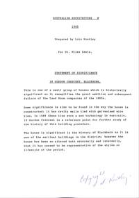
Document - Report, Conservation analysis of 18 Gordon Crescent, Blackburn, 1995
18 Gordon Crescent Blackburn. A conservation analysis undertaken by Lois Routley for Dr Miles Lewis, Lecturer in Architecture. For titles accompanying this study see A-SP-T 13,A-SP-T 14, A-SP-T 15, A-SP-T 16. Includes detailed history of development of the area and occupants of the house.gordon crescent, blackburn, no.18, land subdivision, lewis, miles, woods, john, coppin, george seth, freehold investment and banking company of australia ltd, wolseley crescent, blackburn, blackburn, quarterman, martha, clarke, arthur e, game, kate, t. r. b. morton & son., game, thomas robinson, urquhart, finlay, newman, jeffrey william forbes, newman, valerie, jones, ian, jones, joan, strickland, kenneth william, strickland, wilma dawn -
Lakes Entrance Historical Society
Book, Department of Conservation and Environment, Lake Tyers Foreshore Reserves Management Plan, 1991
An approved management plan relating to the public foreshore land between Lake Bunga and Mill Point. Contains plans and appendices.waterfront, vegetation -
 Eltham District Historical Society Inc
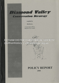
Book, Richard E. G. Brown, Diamond Valley Conservation Strategy: Policy Report, 1995
... conservation, sustainable land use, conservation of resources, waster ...The Diamond Valley Conservation Strategy will be used by Nillumbik and Banyule councils when developing conservation policies. The strategy was developed by the former Shire of Diamond Valley and documents environment and heritage values and possible threats to those values of the former Shire and policy aims and objectives. This report documents flora and fauna conservation, heritage conservation, landscape conservation, sustainable land use, conservation of resources, waster management and community education and involvement. The Shire of Diamond Valley (1964-1994) was abolished in May 1994. Areas merged with the newly created Shire of Nillumbik, City of Banyule and City of Whittlesea.27 p.non-fictionThe Diamond Valley Conservation Strategy will be used by Nillumbik and Banyule councils when developing conservation policies. The strategy was developed by the former Shire of Diamond Valley and documents environment and heritage values and possible threats to those values of the former Shire and policy aims and objectives. This report documents flora and fauna conservation, heritage conservation, landscape conservation, sustainable land use, conservation of resources, waster management and community education and involvement. The Shire of Diamond Valley (1964-1994) was abolished in May 1994. Areas merged with the newly created Shire of Nillumbik, City of Banyule and City of Whittlesea.environmental policy, environmental protection, shire of diamond valley -
Lakes Entrance Historical Society
Book, Department of Conservation Forests and Land with Save the Gippsland Lakes Committee, Gippsland Lakes Algal Bloom Seminar Discussion Paper 1988, 1988
... Department of Conservation Forests and Land with Save the... Book Department of Conservation Forests and Land with Save ...Collected submissions and discussion papers from the Gippsland Lakes Algal Bloom Seminar held in Bairnsdalemanagement, waterways -
Lakes Entrance Historical Society
Book, McGrath, Michelle, Trestle Bridge, 2005
... Conservation and Land Management Culture Analysis Report...Transport Bridges Conservation and Land Management Culture ...Research, interpretation and management recommendations for the trestle bridge at Stony Creek, Nowa Nowa, Gippsland, VictoriaConservation and Land Management Culture Analysis Reporttransport, bridges -
 Eltham District Historical Society Inc
Film - Video (DVD), Melbourne and Metropolitan Board of Works, Yarra River Conference Proceedings; a Board of Works centenary event, 13-16 April 1991
... of tourism; increased interest in conservation and preservation... of tourism; increased interest in conservation and preservation ...Yarra River Conference History Segment [Noted on VHS tape jackets "Due to unavoidable circumstances, the quality of these tapes in some setions is less than desired."] The Yarra River Conference, organised by the Board of Works as part of the Centenary Celebrations, was held in the Board's Head Office Theatrette from 13-16 April, 1991. A segment of the Conference focussed on the role that the Yarra River has played in relation to the historical development of Melbourne. Conceived and presented by a group of prominent historians as a chronological 'trip down the river in time', and profusely illustrated with slides, this segment traced the various impacts that urban and rural growth, development of marine commerce, recreational uses, and environmental problems have had on the Yarra during a century and a half of European occupation. As no formal written paper of this combined presentation is available, these two video-tapes provide a record for anyone who has an interest in tis fascinating aspect of the Yarra's history. The speakers who combined to present this segment are identified on the cover of Tape 2. Tape 1 (2 hours) 1838-1863 Deputy ?? to Utility Early navigators of the Yarra River; developing the port of Melbourne; the gold rush and its effect on the new colony; punts and bridges; water supply; pollution of the Yarra; the discovery of gold and early settlement of the Yarra valley; floods of 1839 and 1863. 1863-1891 Formation of the Harbour Trust; Coode Canal; pollution of the Yarra by industry; aborigines, gold miners, timber getters in the Upper Yarra areas; bridges; the flood of 1891. Tape 2 ( 1 1/2 hours) 1892-1934: People Begin to See Beauty and Romance to the River Henley-on-Yarra; realignment of the Yarra; MMBW is responsible for a sewerage system; new docks to cope with increased overseas trade; development of recreational parks; new reservoirs; timber production and timber tramways; bushfire; flood of 1934. 1935-1970: The River is Neglected Still, Except When it Proves Useful Bushfirs of 1939; the end of many sawmills; birth of tourism; increased interest in conservation and preservation of land for open space; further augmentation of water supply system; birth of containerisation changes the port; environmental concerns gain momentum. Speakers Dr Tony Dingle *, Department of Economic History, Monash University Dr Carolyn Rasmussen *, History Consultant Prof. Graeme Davison, History Department, Monash University Mr. Tom Griffiths, Lecturer in Public History, Monash Uiversity Mr. Patrick Miller, History Consultant Mr. Colin Jones, Author and Historian * Co-authors of the Board's history, 'Vital Connections'.video recording, yarra river, conference proceedings -
 Lakes Entrance Historical Society
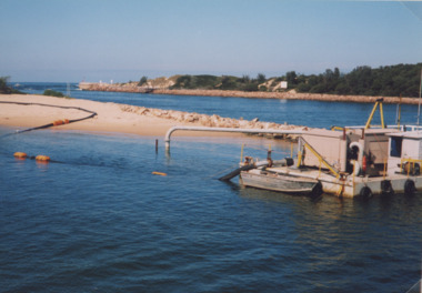
Photograph, small dredge Lakes Entrance Victoria, 1/04/1999 12:00:00 AM
... Ports, Marie Tehan Minister for Conservation Forests and Land, ... Martin of Gippsland Ports, Marie Tehan Minister for Conservation ...Colour photograph of small dredge and pipeline from dredge across sand beside entrance at launch of six month trial of sand transfer pumping system at New Works area Lakes Entrance Victoria. Plus two other photos including Barrie Martin of Gippsland Ports, Marie Tehan Minister for Conservation Forests and Land, environment, waterfront -
 Lakes Entrance Historical Society
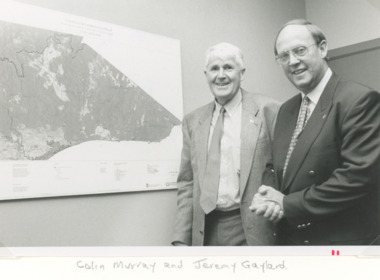
Photograph, Lakes Post Newspaper, East Gippsland Catchment and Land Protection, Lakes Entrance Victoria, 1/12/1995 12:00:00 AM
Black and white photograph of Colin Murray and Jeremy Gaylard at the East Gippsland Catchment and Land Protection meeting during inspection of the area of Lakes Entrance Victoria. Also a colour photograph of upper reaches of the Nicholson River during a dry season environment, wetlands, rivers, conservation -
 Darebin Art Collection
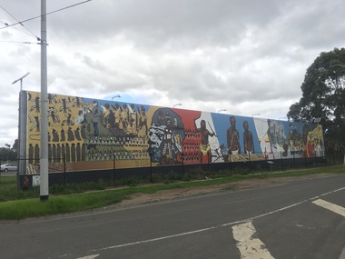
Artwork, other, Megan Evans, Millie Yarran, Ian Johnson, Les Griggs, Elaine Trott and Ray Thomas, Koori Mural, 1983
The Koori Mural was designed by artist Megan Evans in consultation with a committee from the Aborigines Advancement League consisting of the late Lin Onus, the late Molly Dyer, the late Ron Johnson and the late Elizabeth Hoffman. It was painted by Evans and renowned Aboriginal artist Ray Thomas along with Ian Johnson, Millie Yarram, Les Griggs, Elaine Trott and a number of volunteers. The mural has considerable historical and cultural significance and refers to the experiences of the the Aboriginal and Torres Strait Islander communities, from early colonial history to the more recent struggle for social justice. In 2014 the mural was replicated onto a vinyl banner and installed at its current site. The Northcote Koori Mural was originally located on Council land in High Street, Northcote, opposite the Northcote Town Hall. A huge, free-standing wall was built specifically to accommodate the mural which was painted on site. The land on which the mural was housed was later sold, however, and the mural was relocated to the Aborigines Advancement League in St. Georges Road, Thornbury. Conservation work in 2014 and original panels decommissioned and vinyl banner hung in its place (with Total Outdoor Media). In 2015 solar lights were installed along with landscaping to the front of the mural and a plaque depicting the history on the mural. -
 Eltham District Historical Society Inc
Document - Property Binder, 616 Main Road, Eltham; Plum Cottage
Plum Cottage is covered by Heritage Overelay HO256 in the Nillumbuk Planning Scheme This two-lot land holding was created as a subdivision and sold to Charles Stuart McNeil by May 1955. Sometime in the period 1955-1960, the builder-designer, John Harcourt had created a pise house on the site, straddling the two subdivision lots. The designer, John M. Harcourt was a pioneer builder in pise-de-terre and mudbrick in the Eltham Shire, Eltham being synonymous with alternative lifestyles and building practises until the onset of suburbia in the late 20th and early 21st centuries. This hipped-roof house is set high above Main Road on a V-shape plan characteristic of the Arts & Crafts style, with rammed earth or pise walls, timber joinery and a cement tiled roof. The V shape plan was used by important English and Eltham Arts & Crafts designers. The use of natural materials such as stone and timber construction is an essential part of the Arts & Crafts style and Harcourt’s work. So too is the application of the style on both the exterior and interior of the house as a holistic concept. The house adjoins the Lim Joon adobe house built and designed by Alistair Knox in the same era (HO119), thus forming a distinctive pair, both using an uncommon plan form. This house was identified in the Shire of Shire of Eltham Heritage 1992 as contributory to the Eltham Gateway Conservation Area, then proposed as an urban conservation area (now Heritage Overlay Area). Land Ownership Emily Jane Smith of 12 Woodside Street Fitzroy owned Crown Allotments 1 & 2 Sections 14, 27 by August 1918, selling to William Henry Smith of 12 Woodside Street, Nth Fitzroy May 1921. (John) James Isherwood of Main Road, Eltham owned the property by 1928 (the year of his death) with the beneficiary of his estate and next owner of this site being his widow, Minnie Maria Isherwood of Cemetery Road, Eltham. His holding in Main Road included parts of what was described in rate records as allotments1 & 2 Section E6. In the late 1930s, early 1940s her son Alfred John Isherwood was also rated for the land around this site, with the rated nett annual value varying between £2 and £5. Alfred Isherwood also lived at Main Road, Eltham with his wife Ellen: her early death at the age of 24 was reported in the Argus of 1923. Part of the Isherwood land was divided off and sold to Charles Stuart McNeil by May1955. Sometime in the period 1955-1960, the builder-designer, John Harcourt had created a pise house on the site, straddling the two subdivision lots. The house is visible on an aerial photograph from 1960s. Reputedly the house was called Plum Cottage and erected for Harcourt’s mother-in-law. A garage was added in 1959. Charles McNeil died in1971 aged 87: he was the son of Don McNeil and Margaret Arkell. Available rate records from the construction era start in the of the 1970s (1972-3) and list Mr H.C. & M/S A.V. Charity at 616 Main Road Eltham of this property with a nett annual value of $740. More recent valuer's data describes the property as lots 1 & 2 LP25668, located in the Central Riding of Eltham Shire, owned by Ann Valerie Charity and later, in 1990, by the Chincarini family. Building Description This hipped roof 11 .5 square house is set high above Main Road on a characteristic-shape plan and has rammed earth or pise walls, timber joinery and a cement tiled roof. The V-shape plan was used by Important designers such as C.F.A. Voysey (UK) who interpreted medieval domestic architecture as part of the Arts & Crafts style of the late 19th and early 20th centuries. The pise walls are covered with a textured render while the cement roofing tiles are also seen in the Harcourt Hill examples. Reputedly the ceiling joists are of a deep section and span long lengths with no need for hanging beams in the roof space. The ceilings are low and panelled in main rooms with apparently Caneite soft board infill panels between the exposed ceiling beams. These are painted white but may have been stained at one time. The focus of the house is the large living area with its vast random stone fireplace. Significance Plum Cottage is significant to the locality of Eltham because: Historically: • Plum Cottage is closely associated with the important historical theme of earth construction evident in Eltham and elsewhere in the Shire since theear1y Arts & Crafts inspired creations at Penleigh Boyd's The Robins (1912, HO101) and those at Montsalvat (1934-, HO82) but more prominent from the Second War period when earth building in Eltham was promoted in national periodicals as an alternative building method that avoided the building materials shortages of that era; • The choice of the earth building technique also expresses the theme of refuge or alternative living, synonymous with Eltham in the early to mid 20th century; • as a good example of domestic architecture from John Harcourt who was the first major post Second War figure in an important phase of Eltham’s earth building development, using his characteristic Old English or Arts& Crafts style that relies in this case on the pise wall construction, pitched roof forms, exposed ceiling joists, half timbering, random stonework, and panelled internal wall finishes. Architecturally: • Plum Cottage's pise wall construction is uncommon among the early earth-walled structures in the Shire, that are mainly of adobe or mud brick, and as a building material is uncommon among the Shire’s suburban dwellings generally which are clad typically with either fired clay bricks or timber boarding. Aesthetically: • Plum Cottage is a good and well preserved example of a modern Old English or Arts & Crafts style earth-walled building in the Shire • For the proximity of the significant Lim Joon adobe house designed by Alistair Knox adjoining to the north, providing a distinctive earth wall house pair, with uncommon plan forms. Reference Heritage Assessment of Plum Cottage, 616 Main Road, Eltham; Graeme Butler & Associates 2010main road, eltham, property, houses, (john) james isherwood, alfred john isherwood, ann valerie charity, arts and crafts style, charles stuart mcneil, chincarini family, eltham gateway zone, emily jane smith, h.c. charity, heritage assessment, john harcourt, john m. harcourt, lim joon house, main road eltham, minnie maria isherwood, pise construction, plum cottage