Showing 285 items matching "landscape centre"
-
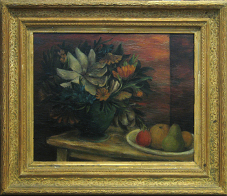
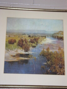 Brimbank City Council Art Collection
Off-Set Lithograph, River Landscape
Off-set Lithograph -
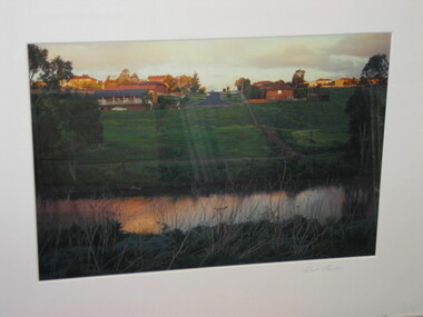 Brimbank City Council Art Collection
Colour Photograph, Robert Pointon, Autumnal landscape, circa 1994
Local SceneColour photograph -
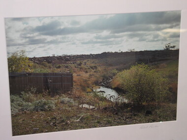
 Brimbank City Council Art Collection
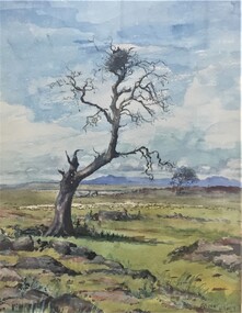
Photograph - Colour Photograph, Landscape, Unknown
UnknownPointon, Robert, Landscape, n.d, Colour Photograph, Brimbank City Council Art Collection, BrimbankColour Photographlandscape -
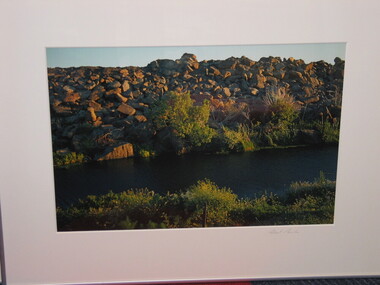
 Brimbank City Council Art Collection
Colour Photograph, Robert Pointon, Landscape
Local scene (?)Colour Photograph -
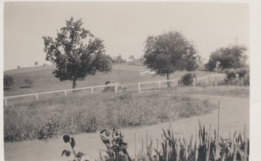 Sunbury Family History and Heritage Society Inc.
Photograph
This is a view of one of the settled parts of Sunbury when it was a small country service town and before its rapid suburban expansion.A black and white photo with a cream border of a landscape in a country town. A driveway is in the foreground wi A small settlement on a distant rise is visible. a post and rail fence in the middle distance and two tries growing beyond the fence line. -
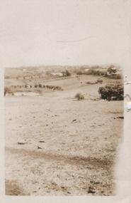 Sunbury Family History and Heritage Society Inc.
Photograph
A portrait view overlooking Sunbury township taken from a hill above the Goonawarra vineyard at the eastern end of the settlement. A sepia photograph with a cream frame of a portrait view of a rural landscape.sunbury township., goonawarra winery -
 Surrey Hills Historical Society Collection
Photograph, Grovedale Road Quarry in the 1920s - looking north, c1920
The quarry was part of John Butler Maling's property. He was one of the original settlers of the area and farmed the area between Weybridge Street and Whitehorse Road. Clay was quarried from part of this area and used to make the bricks used in the construction of his home, known as 'Ancyra'. This is still extant at the corner of Weybridge and James Streets. Maling grazed cows and used the quarry as a water source. He was the uncle of John Butler Maling, Mayor of Camberwell. He was married to Kate Conlon in 1882. They had 3 children: Silas Young, Alick and Zillah. Maling was born in c1829 in Shepreth, Cambridgeshire; he died in Surrey Hills on 9 October 1912 and is buried in Box Hill Cemetery - CE-*-0586. Mrs Kate Maling (born c1859 in Co Meath, Ireland) died at the property on 8 March 1921. She is buried in Brighton General Cemetery. Probate was valued at over 10,000 pounds and included other properties in Sandringham, Hawthorn and Macedon. At the time of her death the Surrey Hills property was described as being 23 cres with 2 brick houses, 1 cow, 2 heifers and 40 fowls or chickens. The property was subdivided after her death. The quarry was filled in after several drownings or near drownings and the land is now occupied by a park and playground maintained by the City of Boroondara. Beckett Park is sited on horizon to the left beyond the trees. This documents the landscape prior to close settlement and is material to early building and farming in the Surrey Hills area.Black and white photo of the quarry between Grovedale Road and James Street taken in the 1920s and looking north. In the foreground is an area of water with high banks dividing the horizontal centre. Beyond are paddocks and trees behind which is a row of at least 3 single-storey houses. Light poles can be seen along a distant street. There are many mature trees in the background. The houses and trees are positioned along Whitehorse Road in the vicinity of Westminster Street. Shadows indicate the photo was taken in early morning or evening.quarries, grovedale road, james street, surrey hills, balwyn, clay quarries, ancyra, kate conlon, kate maling, john butler maling, farming -
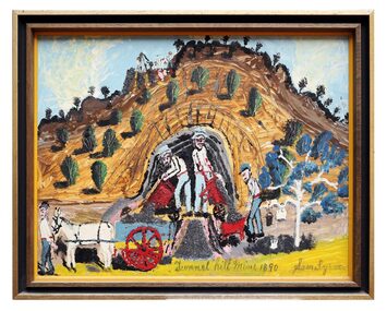 The Dunmoochin Foundation
Mixed Media Painting, Tunnel Hill Mine, 1890, No Date
Mixed media painting (pyrite and enamel) depicting a landscape with four male figures with red wheelbarrows and a horse and cart.Inscribed centre 'Tunnel Hill Mine, 1890' and signed (L.r) 'Sam Byrne'.sam byrne, painting, landscape, mixed media, tunnle hill mine -
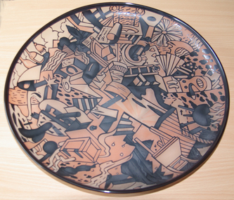
![Ceramic, Bryan Trueman, [Platter] by Bryan Trueman, 08/1982](/media/collectors/530576742162ef0fa09a2288/items/5566ba552162f113608faa40/item-media/60fbe776101cf8a53354c45d/item-fit-380x285.jpg) Federation University Art Collection
Federation University Art CollectionCeramic, Bryan Trueman, [Platter] by Bryan Trueman, 08/1982
Bryan TRUEMAN (13 November 1941- ) Born Derbyshire, England worked in Australia 1975–1992 Bryan Trueman studied at Blackpool School of Art in 1962, undertaking Postgraduate studies at Manchester College of Art in 1963. He toured the east coast of America in 1967-8, then returned to England where he started to train himself in Ceramics. Migrating to Australia in 1975 Bryan Trueman lectured at Caulfield Institute of Technology, Melbourne. In 1982 he opened a studio in Warrandyte, Victoria. Bryan Trueman was a visiting lecturer to the Gippsland Institute of Advanced Education c1982. He is particularly well-known for his painterly use of glazes to depict the Australian landscape, using the platter as the base form. Bryan Trueman was a visiting lecturer to the Gippsland Centre for Art and Design in 1982. This work is part of the Jan Feder Memorial Ceramics Collection. Jan Feder was an alumna of the Gippsland Campus who studied ceramics on the campus. She passed away in the mid 1980s. Her student peers raised funds to buy ceramic works in her memory. They bought works from visiting lecturers who became leading ceramic artists around the world, as well as from many of the staff who taught there. Wheel thrown stoneware platter, with colourful landscape glaze.Bryan Trueman Aug '82ceramics, bryan trueman, gippsland campus, artists, artwork, jan feder memorial ceramics collection, landscape -
 Federation University Art Collection
Painting - Artwork, Lainey Beavis, 'The Enchanted Forest' by Lainey Beavis, 2015
Lainey BEAVIS (1994- ) Born Portland Lainey Beavis completed a Bachelor of Visual Arts (Fine Arts) at the Federation University Arts Academy in 2015. She won the 2015 Art Acquisition Award. The work 'The Enchanted Forest' has been exhibited in the 2015 Federation University End of Year (EYE) Exhibition, and at Brunswick Street Gallery.Framed digital print featuring imagery of Portland's Enchanted Forest. Artist's statement: The photograph captures a dreamlike landscape where one can lose themselves within. It portrays a figure with significant connection to the landscape that it transcends into a sense of euphoria. The image emphasises the beauty of the landscape and the figures passion for it. The figure in the landscape is Rayhna Puche.lower left side '1/5' lower centre 'The Enchanted Forest' lower right side 'L. Beavislainey beavis, artwork, artist, alumni, figure, portland, enchanted forest, photography, rayhna puche, art acquisition award -
 Federation University Art Collection
Painting - Oil, et al, [The Green Vase] by David Strachan, c1948
David STRACHAN (1919–1970) Born 25 June 1919 at Salisbury, Wiltshire, England Arrived 1920 Adelaide, Australia: 1921 Creswick, Victoria David Strachan attended Creswick State School and Geelong Church of England Grammar school. By the age of 16 he wanted to be an artist. Accompanying his mother to London in 1936, he enrolled at the Slade School of Fine Art, where he met Godfrey Miller. In 1937 he attended the Académie de la Grande Chaumière, Paris, and painted at Cassis on the Mediterranean Sea. He returned to Australia in April 1938 and studied at the George Bell School, Melbourne. He had a growing interest in classicism blended with a fascination for the dream-state which was reinforced in his work after he moved to Sydney in 1941. There he was befriended by Jean Bellette and her husband Paul Haefliger, who were to be driving forces behind the Sydney Art Group (founded 1945). He lived on the top floor of the Haefligers' house at Double Bay, and together the three artists drew from models whom the Haefligers hired. In this period Strachan painted and exhibited some of his most poetic works—mainly figurative and landscape subjects, and still-lifes of haunting beauty. His flowers, bowls of fruit, birds, and angelic figures glimmered out of the darkness as things not of this world, evoked faintly, like mythological personages in a gently spoken narrative. He 'spent an erratic war' painting camouflage at Bankstown aerodrome with other artists, among them (Sir) William Dobell, and dancing minor roles with Hélène Kirsova's ballet company. In 1948 Strachan settled in Paris. His paintings, included by Peter Bellew in an exhibition at the Musée National d'Art Moderne, had been well-received by French critics two years earlier. In 1950 he began tentative experiments in etching. These led to the formation of the Stramur-Presse, a business venture which published etchings and lithographs of leading French and English artists. His most important project was a series of twenty-two colour etchings illustrating Alister Kershaw's book of poems, Accent & Hazard (Paris, 1951). Strachan continued to exhibit in Australia and maintained a lively social life with Australian friends. From Paris, he went for weekend painting trips with Moya Dyring in her car and, after 1957, visited the Haefligers on Majorca. He lived in London in 1955-57. His paintings became progressively less soft in effect, his palette brightened, and his forms, especially the still-lifes, became spikier. In the late 1950s his attention drifted towards the study of Hindu philosophers and Jungian psychology. For most of 1957-58 he was enrolled at the C. G. Jung-Institut, Zürich, Switzerland. In 1959 he worked in Silvio Daneo's silkworm factory at Bricherasio, Italy. In May 1960 Strachan returned to Sydney. He lived at Woolloomooloo before buying a house at Paddington in 1963. Over the ensuing years he involved himself energetically with the art scene, exhibiting, teaching (1960-65) at East Sydney Technical College, fund-raising for memorials for Thea Proctor and Dyring, and as the last president (1965) of the Society of Artists. His paintings were out of harmony with the prevailing fashion for abstraction, but he won the Wynne prize for landscape painting in 1961 and 1964 (shared). Perhaps the most moving works of Strachan's last ten years were the mining landscapes, including those he painted near Hill End, leading up to his vast canvas, 'Lewers Freehold Mine'. This was a history picture, depicting the mine as it might have appeared in 1874. He presented it to the Creswick Historical Museum in 1970 in memory of his father. (Barry Pearce, 'Strachan, David Edgar (1919–1970)', Australian Dictionary of Biography, National Centre of Biography, Australian National University, http://adb.anu.edu.au/biography/strachan-david-edgar-11786/text21083, published first in hardcopy 2002, accessed online 6 January 2016.) This item is part of the Federation University Art Collection. The Art Collection features over 1000 works and was listed as a 'Ballarat Treasure' in 2007.Framed still lifefeaturing fruit and flowers.art, artwork, strachan, david strachan, still life, flowers, flora, available -
 University of Melbourne, Burnley Campus Archives
Plan, Hilda Marriott ( Dance), Garden Plans by Hilda Marriott (Dance), 1947-1981
... Plan - MacDonald Memorial & Court, Landscape Architect - H... Plan - MacDonald Memorial & Court, Landscape Architect - H ...Set of 8 plans, including blue-prints, of various gardens, dated c. 1947 - 1981. See paper catalogue for complete list.Plans by Hilda Marriott Dance (1) Sketch plan and 2 blueprint copies of School of Horticulture Burnley. Garden Alterations New Building Area, Working Drawing by H. Dance, Scale ⅟₂₀"=1', 2/4/47, on reverse handwritten,"Proposed Garden Lay-out for New School Building (H. Dance-plan)." (NB Emily Gibson was also involved in the planning of this site.) (2) Tracing paper, paper and blueprint copies of Ararat & District Hospital Garden Plan - MacDonald Memorial & Court, Landscape Architect - H. Dance, Scale 1 inch=8 feet. Includes handwritten note, "Replacement for Ararat Hospital Nov. 1979," list of plants. (3) Blueprint Proposed Design for Garden Watermill Farm, Newbury for Norman Gadsden Esq., Scale ⅟₄₀"=1 ft. (4) Sketch Plan for Garden, Barcombe, Buangor - January 1981 by Hilda Marriott, Scale - Approximate Only - 1:40. (5) Tracing paper copy of plan of Garden at Plumhill, Templestowe, for Mr. & Mrs. Colin Smith. Hilda Dance, Designer 26/4/47, Scale ⅛"=1'. (6) Blueprint Garden House - Sketch. (7) Tracing paper and paper copies Ararat Medical Centre Courtyard Garden, Landscape Architect - Hilda Marriott, Scale - 1:25, Date 8.5.79. (8) Tracing paper copy National Trust of Australia (Victoria) The Heights, Newtown, Geelong Garden Plan, Scale 1:250, Drawn by - Hilda Marriott, Date 12.10.79.(1): on reverse handwritten,"Proposed Garden Lay-out for New School Building (H. Dance - plan)." (2): Includes handwritten note, "Replacement for Ararat Hospital Nov. 1979," list of plants.hilda marriott ( dance), burnley school of horticulture, students -
 Federation University Art Collection
Artwork, other - Artwork - Glass Plate, Tony Hanning, [Glass Platter] by Tony Hanning, 1998
Tony HANNING (1950- ) Dr Tony Hanning is an internationally recognised glass artist whose work is represented in all major collections in Australia and many overseas collections including the V&A Museum in London and the Tacoma Art Museum in the USA. He pioneered the ‘cased’ glass technique that involves two layers of different coloured glass carved in a cameo-like fashion. The imagery in Tony Hanning's work often is representitive of the Gippsland landscape. He has a PhD from Monash Univversity (2008); Master of Arts from Monash University (1998); and a Diploma, Visual Arts, Gippsland Institute of Advanced Education, Monash University, Melbourne (1971). From 1971-1980 Tony Hanning was the Director of Latrobe Valley Arts centre (later Latrobe Regional Gallery, Morwell) Glass platetony hanning, glass, artwork, gippsland campus, churchill, alumni, staffmember -
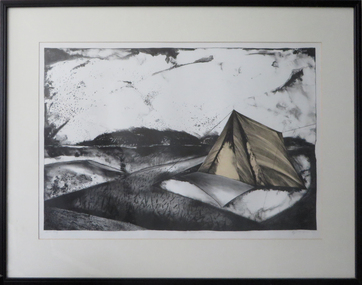 Federation University Art Collection
Work on paper - Artwork - Printmaking, 'Birds Ignite Across the Air' by Kaye L. Green, 1987
Kaye L. GREEN (1953- ) Kaye L. Green was a lecturer in printmaking at the Gippsland Centre for Art and Design. Framed limited edition planographic lithograph depicting a landscape with tents.Signed and dated lower right in pencil "Kaye L. Green '87"printmaking, gippsland campus, churchill, kaye l. green, kaye green -
 Federation University Art Collection
Ceramic, Roswitha Wulff, Woodfired Bowl by Roswitha Wulff, 1986, 1986
"I am an Australian of German parents born in Persia. I was taught by Peter Rushforth, with a very strong Japanese influence. My work attempts to incorporate these four elements of my history. For form, my influence comes from Art Nouveau, or Jugendstil as it is called in Germany. Techniques are informed by pottery from Japan, China, Korea and Germany. My colours are inspired by the Australian landscape. Using the language of woodfiring, I create a personal vocabulary with new subjects, grammar and syntax, which make each pot a one-off object containing all my diverse influences." (Roswitha Wulff)Roswitha WULFF (1941- ) Born Tabrize, Iran. Arrived Austrqalia c1949 Roswitha Wulff spent her early childhood with her mother, potter Helma Klett, in Germany. In 1964, she obtained a ceramics certificate from the East Sydney Technical College. From 1964-65, she worked with Robin Welch and Ian Sprague at Sprague's Mungeribar Pottery in Upper Beaconsfield, VIC. In 1966 she worked at the Sturt Pottery in Mittagong, NSW under Les Blakebrough. Between 1967 and 1969 Roswitha Wulff travelled overseas, spending 6 monthe with Robin Welch after his return to England and 9 months as a full-time thrower at Briglin Pottery, London, as well as working in potteries in Denmark and Germany. From 1969-70, she worked in North-West Pakistan as a research scholar for the Smithonian Institute and the University of NSW. Returning to Australia in 1970, she set up a workshop in Paddington, NSW, with the help of an Australia Council grant and taught part-time at the East Sydney Technical College and the Willoughby Workshop Art Centre. Since then she has been a lecturer and Head of Ceramics in many institutions, including the National Art School. In the 1990s she moved her studio to Botany Bay, NSW.. While working with the vessel form, she sees her pots as abstract landscapes. Recently she has also been working with wall tiles. During a residency at the Canberra School of Art in 2002, she developed tiles that looked like woodfired pillows with soft rounded rims. In 2007, she used such tiles to create a mural commemorating the Sesquicentenary of St Vincent's Hospital in Paddington. Woodfired stoneware bowl with flay ashSigned on baseroswitha wulff, jan feder, jan feder memorial ceramics collection, woodfire, ceramics, gippsland campus, botany bay studio pottery -
 Federation University Art Collection
Drawing, 'Copse' by Tony Hanning, 2015
Tony HANNING (1950- ) Dr Tony Hanning is an internationally recognised glass artist whose work is represented in all major collections in Australia and many overseas collections including the V&A Museum in London and the Tacoma Art Museum in the USA. The imagery in Tony Hanning's work often is representative of the Gippsland landscape. He has a PhD from Mondash University (2008), a Master of Arts from Monash University (1998); and a Diploma, Visual Arts, Gippsland Institute of Advanced Education, Monash University, Melbourne (1971). From 1971-1980 Tony Hanning was the Director of Latrobe Valley Arts Centre (later Latrobe Regional Gallery, Morwell)Framed and mounted charcoal drawing depicting large trees (conifers and probably deciduous) in a field rendered with hatchingLower right, signed Tony Hanning '15tony hanning, staffmember, landscape, trees, treescape, alumni -
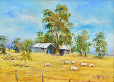 City of Greater Geelong
Painting - Oil on Board, Margaret Greig, Winter at Cathcart, 2009
Part of the 2009 Mouth and Foot Painting Artist Exhibition held at The Shearer's Arms Arts Centre & Visual GalleryLandscape painting of wool shed with sheep in foregroundsheep, mouth and foot painting -
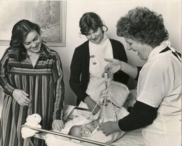 Royal District Nursing Service (now known as Bolton Clarke)
Photograph - Photograph, black and white, c.1980
This photograph depicts a Royal District Nursing Service (RDNS) Sister (Sr.) visiting Mrs. Hodginson and babe in their home. Sr. Wan is weighing baby Tamara as part of the Post-Natal care she is giving. A nurse who is doing her Hospital training is visiting with the Sister and observing. RDNS had a Domiciliary Infant and Maternal Care, (DIMC) service operating from most Centres which visited early discharged, often 24 hours after birth, maternity cases from hospitals to give Post-natal care to the mother and babe. Sr. Wan is wearing her RDNS summer uniform of a short sleeve white blouse under a royal blue V neck tunic style frock and a dark blue cardigan. In August 1893 Melbourne District Nursing Society (MDNS), commenced a Midwifery Service with Nurse Fowler, who was trained in a hospital in General nursing and Midwifery nursing, being the first Midwife employed. Mothers were assessed for suitability of a home birth or if they required delivery at the Women’s Hospital. The Midwife worked in conjunction with the Doctors at the Women’s Hospital and if a complication arose before or after birth the patient was transferred to their care. Following birth, the Midwife gave Post-Natal care to both the mother and babe commencing with visits twice a day. In 1898 the service ceased due to lack of funds but recommenced in 1906, and in the August 1925 Annual Report the number of MDNS home births was recorded at 478. MDNS built the After-Care Home and a pioneering Anti-Natal Clinic was opened in 1930. The last Ante-Natal clinic was held there in December 1951 and the MDNS Midwifery service ceased in February 1952. In 1964 MDNS commenced a Post-Natal service with General and Midwifery trained MDNS Sisters working from a room on the ground floor at the Footscray Hospital Nurses quarters, and visiting early discharged Footscray Hospital maternity cases at home. Later, as Royal District Nursing Service (RDNS), this service was extended and renamed as Domiciliary Infant and Maternal Care, (DIMC) service operating from most Centres and visiting early discharged, often 24 hours after birth, maternity cases from hospitals to give Post-natal care to the mother and babe. Many of the RDNS Sisters who worked in DIMC also had their Infant Welfare Certificate, though Midwifery trained nurses also visited. On the right of the black and white photograph is Royal District Nursing Service (RDNS) DIMC Sister J. Wan, who has short dark curly hair and is wearing a white gown over her uniform, with the white collar and sleeves of her dark cardigan seen. She is laughing as she holds the top ring of hand held baby scales in her right hand; the bottom of the scale has a metal hook which has a sling attached to it with four cotton 'ropes'. Baby Tamara is supported in the sling which is just resting on a sheep skin and bunny rug covered metal framed change table. Sr. Wan has her left hand on the sling. To the left of the photograph is Tamara's smiling mother, Mrs. Lynda Hodginson, and in the centre of the photograph is observer Nurse Sheehan. Mrs. Hodginson is wearing a striped dress with a V neck, and has dark shoulder length hair. Nurse Sheehan has short dark hair and is wearing a white uniform and dark cardigan. A nursing watch is attached to the right hand side of her uniform. Part of a landscape picture can be seen on the wall behind her. A small white fluffy rabbit sits on the left hand side of the change table. Baby Tamara has sparse dark hair and is sucking on a dummy.Photographer's stampmdns, melbourne district nursing society, melbourne district nursing service, royal district nursing service, rdns, mdns midwifery, rdns domiciliary postnatal service, dimc, tamara hodginson, nurse sheehan, sister j. wan, mrs lynda hodginson -
 Melton City Libraries
Pamphlet, Dry Stone Wall Driving Trail, Unknown
"The dry stone walls provide a tangible link to the area’s white settlement, and they remain a symbol of the profound change in land usage from the original Kulin custodians to the European arrivals of the nineteenth century. The bulk of dry stone wall construction in Victoria occurred between the 1850s and 1880s. The gold rush of the early 1850s in particular inspired a flurry of construction. At this time, labour previously available for shepherding livestock dried up, as men gravitated to the goldfields to seek their fortunes. This necessitated the building of fencing to contain the district’s growing number of sheep, cattle and horses. An explosion in surveying, subdivision and the sale of Crown lands also contributed to a boost in construction. Government regulations that punished pastoralists for allowing their livestock to stray provided further incentive to fence-off previously open expanses of land. The major benefit of this type of fencing was that it utilised the materials at hand; the plentiful grey basalt that scattered the landscape. In the case of the dry stone walls built around Melton, the characteristic round or oval shape of the volcanic fieldstones on the western plains inspired some distinctive designs.54 Another advantage of dry stone walls was their ability to withstand the ravages of flood, fire and drought often experienced in the district. This durability accounts for the fact that many of these fences still exist today". Dry Stone Wall trail brochure/pamphlet for visitors provided by Melton Visitor Information Centrecouncil, landscapes of significance -
 Pyrenees Shire Council
painting, Ian L Anderson, School Road, Waterloo by Ian L Anderson, 1995
significant as a work of art by local Pyrenees artist, locally significant to the Central Highlands Region of Victoria as a representation of local landscape and/or culture pastel drawing of a street scene with old house, trees and unpaved road"Signed: IAN L ANDERSON 95 (lower right) Titled: SCHOOL ROAD - WATERLOO (lower centre) Verso (affixed): ""SCHOOL ROAD - WATERLOO"" PASTEL AND CHARCOAL PENCIL PAINTING by IAN L. ANDERSON 14 MILLAR CRESCENT MT WAVERLEY 3145 signed: Ian Anderson '95 $500" -
 Pyrenees Shire Council
painting, The Crows Nest, Warapingo Beaufort by Maude Glover Fleay, 1930
Maude Glover-Fleay studied under Frederick McCubbin, Glover was regarded for her natural history subject matter. She was also a writer and music teacher, and in the 1930s she established a reputation for painting Australian marsupialssignificant as a work of art by a modern era woman artist, locally significant to the Central Highlands Region of Victoria as a representation of local landscape and/or culture watercolour painting of a landscape with large tree at centresigned: Glover Fleay 30 (lower right) -
 Pyrenees Shire Council
painting, Mary Newsome, Belmont by Mary Newsome, 1990
significant as a work of art by local Pyrenees artist, locally significant to the Central Highlands Region of Victoria as a representation of local landscape and/or culture print of a garden and house"signed:Mary Newsome (lower centre) editioned: 1/12 (lower left) titled: Belmonth 20.10.90 (lower right)" -
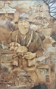 Pyrenees Shire Council
drawing, Michael Vincent-Rori, Settling in the Pyrenees by Michael Vincent-Rori, 2002
significant as a work of art by local Pyrenees artist, locally significant to the Central Highlands Region of Victoria as a representation of local landscape and/or culture Swagman (with puppy) and historical buildings of BeaufortSigned: M. VINCENT-RORI (lower centre) -
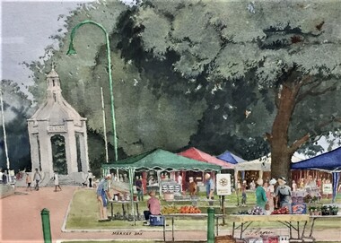 Pyrenees Shire Council
painting, Market Day by Brian Magree
significant as a work of art by local Pyrenees artist, locally significant to the Central Highlands Region of Victoria as a representation of local landscape and/or culture painting of the Beaufort Marketsigned: B Magree (lower right) inscribed: MARKET DAY (lower centre) -
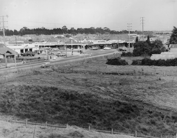 City of Kingston
Photograph - Black and white, c. 1963
This image depicts the intersection of increasing urbanisation and the rural landscape that once made up the area now known as City of Kingston.Black and white photograph of the intersection of Warrigal Road and Centre Road, South Oakleigh, viewed from the reservoir. In the foreground are paddocks and in the background is a shopping strip, including a petrol station.Handwritten in blue ink on reverse: 2196 Handwritten in red ink on reverse: 100%oakleigh, roads, shopping strip, paddocks -
 City of Kingston
Photograph - Black and white, 20 December 1945
This aerial photograph depicts the changing landscape of Cheltenham and Highett since WWII. Photographed in 1945, there is a mix of urban dwellings and industrial development and precedes the major transformation of Cheltenham with the development of the Southland shopping centre in the 1960s and expansion in the 1990s.A large part of Cheltenham was originally established as a rural market gardening community. The railway line and station brought urban development to the area and in the north, the Highett area was dominated by the Highett Gas Works. Cheltenham became a major destination for shopping in the 1960s with the opening of Southland.Aerial photograph taken in 1945 of Cheltenham and Highett within the City of Kingston. The image includes the Highett Reserve, (top right), the Methodist Children Homes (now Southland), Nepean Highway and Jamieson Street. Highett Gas Works is visible in the top left and the land now named William Fry Reserve at the intersection of Bay Road and Nepean Highway. A visible large parcel of land on the corner of Bay Road and Nepean Highway was developed in the 1990s as the west side addition to Southland. The densely vegetated area in the upper right sector of the image is now dense with housing. Tulip Grove, Heather Grove and Gilford Street are visible bottom left. This image is possibly from the collection of aerial photographs commissioned by the Department of Crown Lands and Survey and taken by Adastra Airways.Black ink: 57252 White lettering: VIC-10 57252 20.12.45 [lens information indecipherable] PROJ. No.5 MELB. METROP AREA Black pencil: 80highett, cheltenham, highett gas works, urbanisation -
 City of Kingston
Photograph - Black and white, 20 December 1945
This aerial photograph depicts the changing landscape of Cheltenham and Highett since WWII. Photographed in 1945, there is a mix of urban dwellings and industrial development and precedes the major transformation of Cheltenham with the development of the Southland shopping centre in the 1960s and expansion in the 1990s.A large part of Cheltenham was originally established as a rural market gardening community. The railway line and station brought urban development to the area and in the north, the Highett area was dominated by the Highett Gas Works. Cheltenham became a major destination for shopping in the 1960s with the opening of Southland.Aerial photograph taken in 1945 of Cheltenham and Highett within the City of Kingston. The image includes the Highett Reserve, (top right), the Methodist Children Homes (now Southland), Nepean Highway and Jamieson Street. Highett Gas Works is visible in the top left and the land now named William Fry Reserve at the intersection of Bay Road and Nepean Highway. A visible large parcel of land on the corner of Bay Road and Nepean Highway was developed in the 1990s as the west side addition to Southland. The densely vegetated area in the upper right sector of the image is now dense with housing. Tulip Grove, Heather Grove and Gilford Street are visible bottom left. This image is possibly from the collection of aerial photographs commissioned by the Department of Crown Lands and Survey and taken by Adastra Airways.Black type: Reverse lettering VIC-10 57252 20.12.45 [lens information indecipherable] PROJ. No.5 MELB. METROP AREA White lettering: Reverse writing 57252cheltenham, highett, highett gas works, urbanisation -
City of Kingston
Photograph - Black and white, 5 January 1984
Cheltenham and Heatherton are suburbs in the City of Kingston that were originally established as a rural market gardening community. The market gardens, farms and paddocks have gradually been sub-divided into housing and industrial estates and associated infrastructure such as schools and shopping facilities. This aerial image covers a diverse section of the City of Kingston, taking in the suburbs of Cheltenham, Heatherton, Mentone and Parkdale. By 1984, the market gardens of the district have been replaced by housing and factories. The Nylex factory is visible and now closed. Mentone Bowl on the corner of Warrigal Road and Nepean Highway has now been replaced by high rise apartments, another feature of the changing landscape in the City of Kingston. The vacant land now occupied by the Moorabbin Airport Direct factory Outlet (DFO) is also depicted.Aerial photograph of Cheltenham, Heatherton, Mentone and Parkdale within the City of Kingston. The area depicted in the 1984 aerial view includes Centre Dandenong Road and Cheltenham East Primary School (top left), Kingston Heath Reserve (top right), intersection of Lower Dandenong Road, Warrigal Road, Balcombe Road and Nepean Highway (bottom left), Balmoral Drive/McSwain Street Parkdale (bottom right).White text: 3831-179 Lens information [indecipherable] RINGWOOD M/S 7922-3 RUN 16 [Clockface image] 5,300' ASL VIC DLS© 5-1-84cheltenham, heatherton, mentone, parkdale, market gardens, urbanisation -
City of Kingston
Photograph - Black and white, 17 January 1951
Moorabbin, Cheltenham and Highett are suburbs in the City of Kingston with a diverse mix of development and zoning. This 1954 image shows the market gardens, farms and paddocks of the Moorabbin and Cheltenham area. which have gradually been sub-divided into The Highett Gas Works is visible and Cheltenham Park and Victoria Golf Club.The suburbs of Cheltenham and Moorabbin were originally developed with extensive market gardens. Over time the district has been transformed with the farms and paddocks replaced by housing, factories and shopping centres. The Highett Gas Works on the Nepean Highway was a significant feature of the landscape and has now been demolished. and the site has undergone remediation.Aerial photograph of Cheltenham, Moorabbin and Highett within the City of Kingston. The area depicted in this 1951 aerial view includes Wickham Road, Highett (bottom right), Keys Road, Moorabbin (bottom left), Centre Dandenong Road Cheltenham (top left), Park Road, Cheltenham (top right), Nepean Highway (left section), Graham Road and Middleton Street, Highett (bottom right). Cheltenham Park and Victoria Golf Club are visible. Nepean Highway and the Frankston railway line run centrally through the image.White type: 1416-37 538 RUN239 LENS 5312" MELBOURNE METROPOLITAN 12150 17-1-51 ↆ M539 Black pencil: N [arrow]cheltenham, highett, highett gas works, market gardens -
City of Kingston
Photograph - Black and white, 20 December 1945
This aerial image covers a section of Cheltenham, with a large paddock yet to be converted to an industrial and later a commercial zone.This aerial photograph provides evidence of the changing landscape of Cheltenham and Highett since WWII. Photographed in 1945, the image features a large block of land now the site of site the major transformation of Cheltenham with the development of the Southland shopping centre in the 1960s and expansion in the 1990s.Aerial photograph of the Cheltenham area in the City of Kingston. This 1945 image is concentrated on the area between Bay Road and Garfield Lane with the distinctive bend into Jean Street. A large block of land runs between the Nepean Highway and the rail line. This is now the area occupied by the extension of Southland in the 1990s.cheltenham, southland, aerial photograph, highett