Showing 5329 items
matching levelling
-
 Glenelg Shire Council Cultural Collection
Photograph - Photograph - Cape Grant Quarry, 09/01/1959
Port of Portland Authority ArchivesBack: Purple PHT stamp. '9 JAN 1959'port of portland archives, cape grant quarry -
 Falls Creek Historical Society
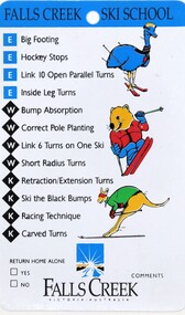
Memorabilia - Falls Creek Ski School Lesson Card
These items are from the private collection of George Shirling of Red Onion, Falls Creek. A lesson card and skills list from the Falls Creek Ski School. George Shirling arrived in Falls Creek in 1962. He engaged Phil Nowell to build the original Koki Alpine Lodge which opened in 1965 with 14 beds. George operated the lodge with Michael “Baldy” Blackwell as manager. He also graduated in sport psychology in 1981 and was invited to become team psychologist for the Australian Winter Olympic team which went to Albertville, France, in 1992. He later owned the Red Onion Chalet. George credited the success of Koki to “Baldy” Blackwell. “Baldy” and Phil Nowell started the Trackers Mountain Lodge in partnership during the 1980s. In 1971 George sold Koki Lodge to Sigi Doerr. In 2024 the renamed Koki Alpine resort remains a highly popular destination in Falls Creek. George Shirling passed away on 27th February 2023. He had remained actively involved in Falls Creek and was generous with his time and knowledge, always an amazing supporter of The Falls Creek Museum and Falls Creek Village.This item is significant because it is representative of the programs available at the Falls Creek Ski School.A colourful card plastic card featuring colourful characters which represent the different ability levels in the Falls Creek Lesson program. Each character is placed beside a list of skills for that level. These are Koala, Possum, Cockatoo, Emu, Wombat and Kangaroo.Animal characters and itemised list of relevant skills.george shirling, falls creek ski school -
 Kiewa Valley Historical Society
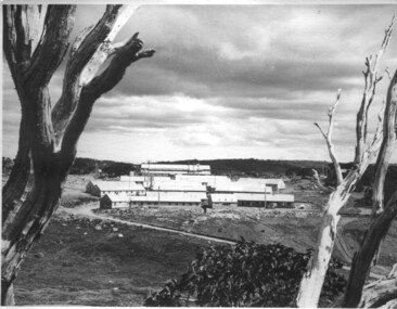
Photograph of Pretty Valley Workers Camp*, Pretty Valley Camp, circa 1949
Erection of staff quarters at Pretty Valley was completed in April, 1947 and accommodation for construction workers commenced in 1948 but suspended on 11th May for winter and resumed on 9th November. Construction of this camp was completed in 1949. A large dam was proposed at this site but was never constructed. Instead a small diversion dam was built which diverts water either to Rocky Valley Dam or to McKay Creek Power Station.An historical record of the type of accommodation provided for workmen during the construction of the Kiewa Hydro Scheme during the 1940's/50's.A black and white photograph of Pretty Valley Camp, c 1949. Dead trees are in the foreground, on both the left and right side of the photograph and a small snow gum is evident. There are camp huts and a much larger building behind these, possibly a workshop, and power poles are evident bringing electricity to the site.Handwritten in blue ink on back of photograph "Pretty Valley Camp. 5600 ft. above sea level".pretty valley, dam, water, workmen, camp -
 Whitehorse Historical Society Inc.
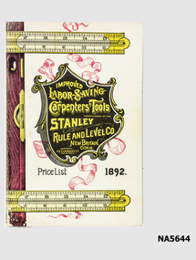
Book - Stanley Carpenters' Tools Price list 1892, H.G. Maddocks Jr, July 1972
Re-produced tool catalogueReproduced catalogue of Stanley Tools 1892.Improved labor-saving carpenters tools manufactured by Stanley Rule & Level Co. New Britain Conn.tools, carpentry, history -
 Warrnambool and District Historical Society Inc.
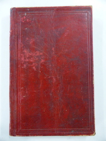
Book, John Ross notebook, 1890s
This small note book belonged to John Ross, the Warrnambool Town Surveyor and Engineer (1889-1906 & 1913-1914). The book lists the levels taken for the benefit of contractors undertaking jobs for the Warrnambool Council from 1898 to 1902. The jobs include ‘Russells Creek from the Merri River upwards’, ‘Outlet at the Flume’, ‘Guns at the Battery’ and Drainage from the Terminus Hotel to the end of the Japan Street Tunnel’. John Ross was also in private practice with the architectural firm of Ross and Jackman. This notebook is of considerable interest because it is an original note book that belonged to John Ross, the Warrnambool Town Surveyor and Engineer in the late 19h century and early 20th century. The note book contains important information on the engineering projects in Warrnambool and district from 1898 to 1902. This note book has a red leather cover. The cover is a little creased. The inside pages have ruled red lines and printed headings regarding the levels taken of a site and the location of the site (1898 to 1902). The engineer’s entries in the printed columns are handwritten , mostly in pencil. The inscription on the first page is handwritten in black ink. ‘Jno C Ross, Town Surveyor Wbool 19/5/98’ john ross, warrnambool town council, history of warrnambool -
 Melbourne Tram Museum
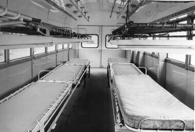
Photograph - Black & White Photograph/s, Public Transport Corporation (PTC), 1940's
Black and white print of the interior of the MMTB Ambulance bus made by Preston Workshops for Workshops use. Shows 6 beds on the lower level and more on the upper level. Photo from the PTC Historic Photo collection with copyright stamp on rear - H8012Atrams, tramways, mmtb, world war 2, buses, ambulances -
 Bendigo Historical Society Inc.
Map - FORTUNA HUSTLER'S MINE - PLAN OF THE FORTUNA HUSTLER'S MINE
Plan of the Fortuna Hustler's Mine, Bulletin No 33, Plate No II. Geological Survey of Victoria. Signed by H A Whitelaw, Underground Survey Office Bendigo, September 1913. Map shows levels and depths. There are smaller drawings of some sections of some levels. mining, parish map, fortuna hustler's mine, plan of the fortuna hustler's mine, geological survey of victoria, h a whitelaw, underground survey office bendigo -
 City of Kingston
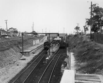
Photograph - Black and white, Public Transport Corporation, c. 1959
Black and white photograph of Moorabbin railway station, at the completion of works to relocate it to below street level. There are two "red rattler" trains pulled in to the station, utilising each of its two tracks and two of its three platforms. A third platform is visible to the left of the image, but no tracks have been laid to allow for an additional train. This image is part of a larger collection of images from the Public Transport Corporation displaying train stations and streetscapes in what is now the City of Kingston.Black and white photograph of Moorabbin railway station, at the completion of works to relocate it to below street level. There are two "red rattler" trains pulled in to the station, utilising each of its two tracks and two of its three platforms. A third platform is visible to the left of the image, but no tracks have been laid to allow for an additional train. Stamped in blue ink on reverse: COPYRIGHT / Public Transport Corporation / For re-ordering photographs / Please quote negative No M6859 / Enquiries C/- PTC Photographic Unit / Telephone switchboard 619 111moorabbin, railway station, red rattler, public transport -
 Glen Eira Historical Society
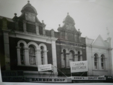
Historical Caulfield to 1972, photo album by Jenny O’Donnell, Glen Huntly Rd
1 photo of upper level of shops including Barkers, Eddies Butcher, Big N Discountelsternwick, buildings, glen huntly rd, barkers, eddies butcher, big n discount, o’donnell, jenny -
 Federation University Historical Collection
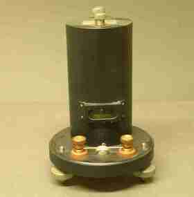
Scientific Instument, J.L. William Instruments, Galvonometer
A ballistic galvonometer in black sealed metal enclosure, of cylindrical shape on a circular base, with levelling feet. scientific instrument, galvonometer, ballistic galvanometer -
Glenelg Shire Council Cultural Collection
Photograph - Photograph - Lee Breakwater, Portland, n.d
Port of Portland Authority Archivesport of portland archives, lee breakwater, wharf, portland -
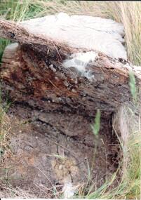 Hume City Civic Collection
Photograph, early 1990's
The set of 20 photographs were taken of a number of archaeological sites in Sunbury of sacred sites and aboriginal rings. The photographs were included in a study of these sites which was published by the Shire of Bulla in the early 1990's.A soil profile showing a whitened lava flow above decomposing timber and soil at the lower level.aboriginal ring sites, george evans collection -
Whitehorse Historical Society Inc.
Document, Mitcham level crossing removals, 2013
Collection of documents including Community Updates on level crossing removals on Morcam and Rooks Road Mitcham.Collection of documents including Community Updates on level crossing removals on Morcam and Rooks Road MitchamCollection of documents including Community Updates on level crossing removals on Morcam and Rooks Road Mitcham.mitcham road mitcham, mitcham railway crossing, mitcham railway station, rooks road mitcham -
 Sunbury Family History and Heritage Society Inc.
Photograph, 2001
The water tank stands on Sunbury Railway station and was in use when steam trains were used along Bendigo line. After travelling 37 kms (25 miles) from Melbourne, it was necessary for the trains to replenish their water supply at Sunbury. The presence of the water tank at Sunbury Station is an indicator that it was one of the major stations along the Bendigo line. A coloured photograph of a rectangular water tower. The first level is a brick construction and the metal tank is on top of it. water tanks, railway stations, steam travel -
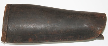 Trafalgar Holden Museum
Functional object - Double buckle leather puttees
Leather lower leg protection Manufactured and sold by Holden and Frost circa 1900Brown leather lower leg protectors straps across unit and buckle fastened at knee levelleather, puttee's -
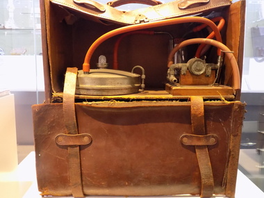 Geoffrey Kaye Museum of Anaesthetic History
Machine - Insufflation anaesthesia machine
In 1913, Mark Cowley Lidwill designed a machine for the purpose of mechanical or insufflation anaesthesia. The Lidwill machine was a portable machine weighing 7kg that could easily be packed into two small bags. The machine involved compressed air being delivered to an ether vaporiser. An ether/air control device allowed varying concentrations of ether to be delivered. The ether vaporiser could be immersed in hot water to prevent cooling and the ether temperature was measured. From the vaporiser, the ether/air mixture went through a trap bottle, then to a crude mercury blow-off valve and subsequently to the patient.Large leather suitcase style bag divided into two levels containing and insufflation anaesthesia machine.insufflation, mark cowley lidwill, thoracic surgery, positive pressure -
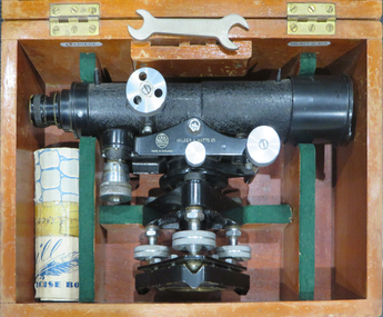 Federation University Historical Collection
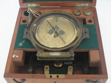
Instrument - Scientific Instrument, Dumpy Level, 05/1950
Used for surveying classes at the Ballarat School of Mines.Telescope with cross hairs and stoidia wites. Internal focussing. Vertical tilt adjusted with vernier mocrometer screw mirror lid longitudinal bubble level. Pea bubble level on plate. Housed in wooden storage carry box. Fits tripod cat. no. 4118Serial number 67543 On box lid in white paing "L 6". In yellow paing "59". Inside box lid - Manufacturers label; grades table label, calibration label reading "instrument No 67 543, date 13.5.50" (ink faded) constant: +0.19 ft"dumpy, level, surveying, scientific instrument, e.r. watts & son ltd, ballarat school of mines -
 Ballarat Tramway Museum
Photograph - Black & White Photograph/s, late 1940's or 1950's
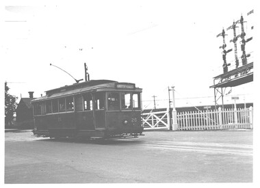
Yields information about the appearance of tram No. 26 crossing the railway level crossing in Lydiard St Nth and the railway features at this location.Black and white photograph of Ballarat tram No. 26 crossing the Railway level crossing in Lydiard St Nth. The tram has the destination of Grey St Sebastopol. In the background is the railway level crossing gates, the goods shed and the signal gantry. Two copies held.On rear in ink (Lloyd's hand writing) - "Ballarat, Lydiard St railway crossing, 27-2-1954, ARHS neg."trams, tramways, lydiard st nth, railway crossing, grey st, tram 26 -
 St Kilda Historical Society
Photograph, Tram at Elsternwick Station level crossing, c. 1958
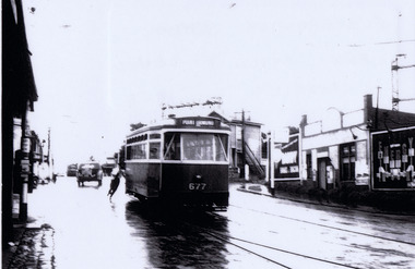
laminated black and white photograph (2 identical)Tram destination Point Ormond at Elsternwick Station when still a level crossing 195. Point Ormond 677. -
 Kew Historical Society Inc
Photograph - Flooding of the Yarra Valley at Kew East, 1974
Flooding of the Yarra Valley, including that section of the Yarra bordering Kew and Kew East in the north and west of the municipality, was a regular occurrence. Extreme flood events of the Yarra River are recorded to have occurred in 1891, 1901, 1916, 1923 and 1934. The Municipality of Kew's response to these floods was to enact planning decisions restricting residential development in flood prone areas following the floods of 1916, 1921 and 1934. While floods continued after the development of the Upper Yarra Reservoir (construction 1948-57), the regularity and extent of these inundations diminished. During the nineteenth century, the land abutting the south side of the Yarra in Kew was devoted to dairy farming. In the twentieth century, before and after the construction of the Eastern Freeway, much of this low-lying area was used as golf courses and public parks.Late example of the capacity of the Yarra Valley at Kew to flood, even though drainage works and the Upper Yarra Reservoir had reduced their regularity.Original black and white print photograph of the low-lying land at East Kew under floodwater on 16 May 1974. The vantage point of the photographer is Lister Street. Flooding was caused by overflowing water in Glass' Creek and the River Yarra. Annotation verso: "Lister Street looking north / Flood level / 16 May 1974 11.30am / R.L. 46.04"hays paddock, floods, yarra river, glass' creek, lister street -
 Federation University Historical Collection
Instrument - Scientific Instrument, Miner's Dial, mid 1800s
A quadrant mounted telescope with crosshairs and external focussing, with longitudinal bubble level. Mountable on a magnetic compass plate with two bubble levels. Complete with dapered-spigot base plate and slot view attachments, Housed in a polished timber box. Inside the box are two labels -A label on the inside of the box " to the School of Mines and Industries, Ballarat" To (...) Hoadley, Esq, Principal, Footscray Technical school, Footscray WII" "Sluggish Needle, 9/4/3..." "still sluggisg 1966"mining, ballarat school of mines, surveying, archibald hoadley, scientific equipment, circumferential, scientific instruments -
 Bendigo Historical Society Inc.
Document - ALBERT RICHARDSON COLLECTION: WATTLE GULLY GOLD MINE
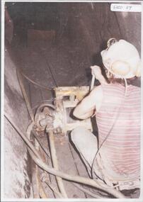
Black and white photo, faded, laminated. Image shows Ken Bice operating a scraper. On back of image ' Ken Bice operating a scraper in intermediate level 6 metres agove No. 1 level (60m) Wattle Gully Mine 1980 working on Gibbers Reef.'mining, underground equipment, wattle gully gold mine -
 Bendigo Historical Society Inc.
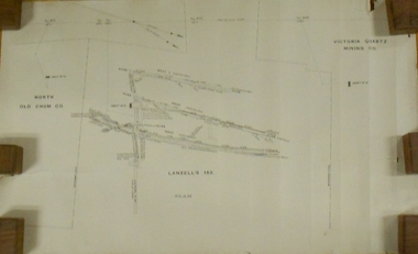
Plan - MARKS COLLECTION: LANSELL'S 180 PLAN, LEVELS 18, 19 AND 20
Plan of underground section of Lansell's 180 mine, levels 18, 19 and 20. On RH side of map Victoria Quartz Mining company claim marked, on LH side North Old Chum Co. 'West or hanging wall' marked above each level.bendigo, mining, lansell's little 180 mine -
Glenelg Shire Council Cultural Collection
Photograph - Photograph - Cape Grant Quarry, n.d
Port of Portland Authority ArchivesBack: '(3) - pencil, top right cornerport of portland archives, cape grant quarry -
Glenelg Shire Council Cultural Collection
Photograph - Photograph - Cape Grant Quarry, n.d
PORT OF PORTLAND AUTHORITYBack: Purple PHT stamp -
Glenelg Shire Council Cultural Collection
Slide - Slide - Cashmore Airport, Portland, 1980s
Coloured slide. Large flattened area, built up to be same level. Several rollers and graders in background.portland airport, cashmore airport, construction, engineering, air travel -
Federation University Historical Collection
Document, Peter Fryar, A short history and discussion paper regarding factors influencing the introduction of "Physical Education" courses into Victorian Tertiary Education and to Ballarat Post Secondary Institutions in particular, by Peter Fryar
Retired Dean of the Faculty of Human Studies, Peter Fryar, was invited to prepare this short history for lodgement in the University of Ballarat Historical Collection (later Federation University Historical Collection).10 typed pages by Peter Fryar outlined introduction of Physical Education studies at a Tertiary Level at Ballarat peter fryar, physical education, mount helen campus -
 City of Ballarat
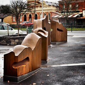
Artwork, other - Public Artwork, Cliff Burtt, Buninyong Bivium, 2016
Buninyong Bivium (2016) by Cliff Burtt engages with the geography and history of the Buninyong region in both pre and post settlement. The town of Buninyong is dominated by the profiles of Mt Helen and the extinct volcano Mt. Buninyong. Traditional land of the Wadawurrung people, today the area remains a significant site for the culture of indigenous people and their connection to the land. The profile of this sculpture is based on topographical mapping of the area, depicting sections of the landscape. The gaps between the elements of the work can be viewed as representations of the shafts sunk into the earth by the early gold miners and compound curves on the upper surfaces are mirroring the topography of the area, while cut-aways in the sides are suggestive of rock strata.The artwork is of aesthetic and social significance to the people of BallaratCorten steel sculpture made of five unique sculptural pieces secured to at concreate base at pavement levelbuninyong, cliff burtt, sculpture, public art, mining, ballarat -
 Whitehorse Historical Society Inc.
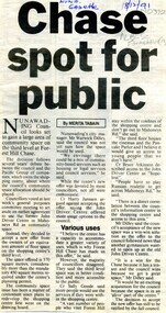
Article, Chase spot for people, 1991
Nunawading Council may gain a large area of community space on the 3rd level of Forest Hill Chase.Nunawading Council may gain a large area of community space on the 3rd level of Forest Hill Chase.Nunawading Council may gain a large area of community space on the 3rd level of Forest Hill Chase.forest hill chase, nunawading -
Whitehorse Historical Society Inc.
Document, Eastern suburbs map, n.d
Hand drawn map of eastern suburbs and railways of eastern suburbs showing heights above sea levelrailways, maps