Showing 218 items matching "library block"
-
 Kew Historical Society Inc
Plan, Melbourne & Metropolitan Board of Works : Borough of Kew : Detail Plan No.1574, 1905
The Melbourne and Metropolitan Board of Works (MMBW) plans were produced from the 1890s to the 1950s. They were crucial to the design and development of Melbourne's sewerage and drainage system. The plans, at a scale of 40 feet to 1 inch (1:480), provide a detailed historical record of Melbourne streetscapes and environmental features. Each plan covers one or two street blocks (roughly six streets), showing details of buildings, including garden layouts and ownership boundaries, and features such as laneways, drains, bridges, parks, municipal boundaries and other prominent landmarks as they existed at the time each plan was produced. (Source: State Library of Victoria)This plan forms part of a large group of MMBW plans and maps that was donated to the Society by the Mr Poulter, City Engineer of the City of Kew in 1989. Within this collection, thirty-five hand-coloured plans, backed with linen, are of statewide significance as they include annotations that provide details of construction materials used in buildings in the first decade of the 20th century as well as additional information about land ownership and usage. The copies in the Public Record Office Victoria and the State Library of Victoria are monochrome versions which do not denote building materials so that the maps in this collection are invaluable and unique tools for researchers and heritage consultants. A number of the plans are not held in the collection of the State Library of Victoria so they have the additional attribute of rarity.Original survey plan, issued by the MMBW to a contractor with responsibility for constructing sewers in the area identified on the plan within the Borough of Kew. The plan was at some stage hand-coloured, possibly by the contractor, but more likely by officers working in the Engineering Department of the Borough and later Town, then City of Kew. The hand-coloured sections of buildings on the plan were used to denote masonry or brick constructions (pink), weatherboard constructions (yellow), and public buildings (grey). This plan shows several very large houses, particularly along Glenferrie Road, and the area now occupied by Ruyton Girls’ School. ‘Tarring’ (incorrectly spelled here as ‘Karring’) was built for Henry Henty in 1872, on part of his original allotment of 20 acres, and ‘Mount View’, which retains its original building and the fountain in the front garden, is part of Ruyton’s Junior School. The most significant change to Tarring and its grounds since 1903, involve the removal of a number of the outbuildings, including a Burmese temple, bought by Henty from the Burmese Exhibit at the Great Exhibition of 1880. It is shown on the plan as a summerhouse. The two-storey mansion, on the corner of Glenferrie Road and Wellington Street, was built in 1891 by leading architect Alfred White as his own home. Having an initial N.A.V. of £160, the house was purchased by a warehouseman Henry Lister, by 1900, when the N.A.V. was recorded at £111. By the turn of the century the house was known as ‘Comaques’. By contrast, much smaller houses are shown in Scott and Byron Streets, including a tiny Mission Hall in Byron Street, which belonged to the Anglican Church from at least 1903 to 1917.melbourne and metropolitan board of works, detail plans, maps - borough of kew, mmbw 1574, cartography -
 Kew Historical Society Inc
Plan, Melbourne & Metropolitan Board of Works : Borough of Kew : Detail Plan No.1575, 1905
The Melbourne and Metropolitan Board of Works (MMBW) plans were produced from the 1890s to the 1950s. They were crucial to the design and development of Melbourne's sewerage and drainage system. The plans, at a scale of 40 feet to 1 inch (1:480), provide a detailed historical record of Melbourne streetscapes and environmental features. Each plan covers one or two street blocks (roughly six streets), showing details of buildings, including garden layouts and ownership boundaries, and features such as laneways, drains, bridges, parks, municipal boundaries and other prominent landmarks as they existed at the time each plan was produced. (Source: State Library of Victoria)This plan forms part of a large group of MMBW plans and maps that was donated to the Society by the Mr Poulter, City Engineer of the City of Kew in 1989. Within this collection, thirty-five hand-coloured plans, backed with linen, are of statewide significance as they include annotations that provide details of construction materials used in buildings in the first decade of the 20th century as well as additional information about land ownership and usage. The copies in the Public Record Office Victoria and the State Library of Victoria are monochrome versions which do not denote building materials so that the maps in this collection are invaluable and unique tools for researchers and heritage consultants. A number of the plans are not held in the collection of the State Library of Victoria so they have the additional attribute of rarity.Original survey plan, issued by the MMBW to a contractor with responsibility for constructing sewers in the area identified on the plan within the Borough of Kew. The plan was at some stage hand-coloured, possibly by the contractor, but more likely by officers working in the Engineering Department of the Borough and later Town, then City of Kew. The hand-coloured sections of buildings on the plan were used to denote masonry or brick constructions (pink), weatherboard constructions (yellow), and public buildings (grey). Plan No.1575 shows that in the area bounded by Wellington Street, Edgevale Road, Glenferrie Road, and Cotham Road, there had already been significant subdivision of land and houses constructed. As one of the highest points in Kew, as expected, there were already some significant mansions built on large allotments of land. Many of these mansions are identified by name on the plan such as ‘Kelso’, ‘Abbotsford’, ‘Clarendon’ and ‘Ashlyn’ in Cotham Road. Other houses of equal size are unnamed on the plan.melbourne and metropolitan board of works, detail plans, maps - borough of kew, mmbw 1575, cartography -
 Surrey Hills Historical Society Collection
Photograph, Grovedale Road Quarry in the 1920s - looking south, c1920
The quarry was part of John Butler Maling's property. He was one of the original settlers of the area and farmed the area between Weybridge Street and Whitehorse Road. Clay was quarried from part of this area and used to make the bricks used in the construction of his home, known as 'Ancyra'. This is still extant at the corner of Weybridge and James Streets. Maling grazed cows and used the quarry as a water source. He was the uncle of John Butler Maling, Mayor of Camberwell. He was married to Kate Conlon in 1882. They had 3 children: Silas Young, Alick and Zillah. Maling was born in c1829 in Shepreth, Cambridgeshire; he died in Surrey Hills on 9 October 1912 and is buried in Box Hill Cemetery - CE-*-0586. Mrs Kate Maling (born c1859 in Co Meath, Ireland) died at the property on 8 March 1921. She is buried in Brighton General Cemetery. Probate was valued at over 10,000 pounds and included other properties in Sandringham, Hawthorn and Macedon. At the time of her death the Surrey Hills property was described as being 23 acres with 2 brick houses, 1 cow, 2 heifers and 40 fowls or chickens. The property was subdivided after her death. The property was subdivided into 110 house blocks in c1923 - see Maling's Estate subdivision flyer on the State Library of Victoria's website. This shows that the Grovedale Park site had been acquired by Camberwell Council by this time. An attached newspaper clipping documents prices realised for a cross-section of blocks. The MMBW map of 1925, also on the SLV website, shows the outline of the clayhole / quarry. The quarry was filled in after several drownings or near drownings and the land is now occupied by a park and playground, known as Grovedale Road Park, maintained by the City of Boroondara. Beckett Park is sited on horizon to the left beyond the trees. This documents the landscape prior to close settlement and is material to early building and farming in the Surrey Hills area.Black and white photo of the quarry between Grovedale Road and James Street taken in the 1920s and looking south. In the foreground is an area of water with reeds in the LH corner. Beyond on the high banks there are single storey houses in the background and (?) some light poles. An object that looks like a tank on posts is in a cutting on the far bank.quarries, grovedale road, james street, clay quarries, farming, kate conlon, kate maling, john butler maling, ancyra -
 Vision Australia
Text, Royal Victorian Institute for the Blind annual report 1960-1961, 1960-1961
Articles in annual report include: List of RVIB president, office bearers of the institute and officers of the institute, Programme and achievements - future programme is in your hands, Activities, Programme maintained - ninety six years of service, Recent years, Resident nursery and school, Other children's activities, Deaf blind children, Higher education, Employment, Finance, Rehabilitation, Recreation and social activities, Talking book library, Public appeal - Aug 1962, Appreciation, 3KZ Christmas day appeal, Concerts, Board of management, 35th annual report of council of auxiliary. Events that occurred in 1961 : School started a scented garden, library now has been consolidated and a new physical education block opened with an indoor heated pool, fully equipped gym, showers and dressing room.1 volumeroyal victorian institute for the blind, annual reports -
 Vision Australia
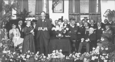
Photograph - Image, Free Lending Library of the Blind building opening, 1919
In 1894 the Victorian Braille Writers Association was established in order to create a braille lending library. Such an endeavor also meant a need of space for storage. At first the library was accommodated in the home of Mrs May Harrison before moving to the home of Mrs Dickinson two years later. Eventually, with the help of donors, a space was rented in the Block Arcade to house the 1300+ volumes it held and the yearly increase produced by its braille transcribers. Fortunately in 1918 the Trustees of the Edward Wilson Estate provided 4000 pounds to pay for a new building in Commercial Road. Despite some misgivings from the RVIB at the time, this building was home to both braille volumes and talking books (albums and cassettes) for many years.1 b/w photograph of people on a stageFree Lending Library for the Blind. Senator G. Fairbairn, on behalf of the Edward Wilson Trust, presenting the key of the building to Miss Aston, a Braille reader, representing the Braille Writer’s Association. 26th April 1919. (Label on mount board)tilly aston, braille and talking book library -
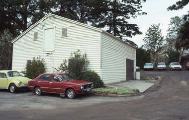
 University of Melbourne, Burnley Campus Archives
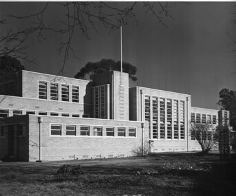
Photograph - Black and white print, Commercial Photographic Co. Pty. Ltd, Administration Building, 1949
Note by T.H. Kneen 20 February 1991, "East facade of building L to R Library over Assembly Hall, change rooms, classroom block, offices for school staff & three branches of Department of Agriculture, Principal's office to extreme right." 2 copies black and white photograph. Taken further to the left of B91.24On reverse, "1949 Commercial Photographic Co. Pty. Ltd. FJ 5266 When ordering further prints please quote K370-6".library, assembly hall, change rooms, classroom block, office, staff, principal, administration building, branches dept of agriculture, main building -
 Vision Australia
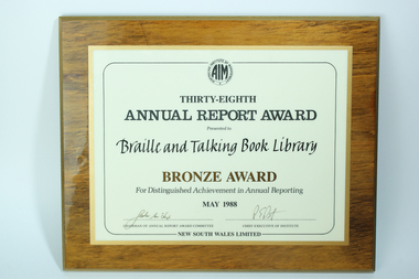
Photograph - Image, 38th Annual Report Awards - Bronze Award for Distinguished Achievement in Annual Reporting, 1988
The award reads as follows: Australian Institute of Management 38th Annual Report Award presented to Braille and Talking Book Library Bronze Award for Distinguished Achievement in Annual Reporting, May 1988 (Signed by) Chairman of Annual Report Award Committee (and) Chief Executive of Institute New South Wales Limited Digital image of rectangular wood block with paper certificate laminated to front:Australian Institute of Management 38th Annual Report Award presented to Braille and Talking Book Library Bronze Award for Distinguished Achievement in Annual Reporting, May 1988 (Signed by) Chairman of Annual Report Award Committee (and) Chief Executive of Institute New South Wales Limitedbraille and talking book library, awards -
 Vision Australia
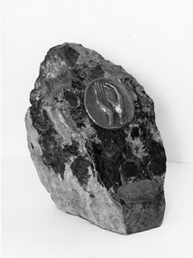
Sculpture - Object, Matcham Skipper, 1974 Braille Book of the Year award, 1974
Made from a large, heavy, irregular shaped piece of stone. One fascia has been cut lengthwise at an oblique angle & polished. On this face are 2 bronze medallions. One shows 2 hands and the other, 'Braille Book of the Year' is written in Braille. This award was presented for the first time at a presentation dinner on the 3rd May 1974 to Mr. Keith Dunstan. Mr. Barrett Reid of State Library, Dr. Stephen Murray - Smith from Melbourne University and Mr. Lloyd O'Neil, publisher formed the literary panel.1 stone block with 2 bronze medallions, one inlaid with hands and the other with BrailleBraille Book of the Year (in Braille)braille and talking book library, awards, sculpture -
 University of Melbourne, Burnley Campus Archives
Photograph - 35mm Colour slides, Miscellaneous, 1969-1987
1. "Hockey 1969 R. Hamley Foreground" Jul 69. 2-5. "Clearing Tech Block Site" Jul 69. 6. Garden view Dec 75. 7. "Nursery Block from College Building" (roof) Mar 77. 13-14 slides garden beds in front of Administration Building Sep 81. Garden view Feb 87.23. "Wide World of Gardening' display Mar 86. 17-19 View towards Plant Research Institute. 15-16, 21-22 Construction New Library. hockey, 1969, r. hamley, tech block site, garden views, garden beds, administration building, nursery block, wide world of gardening display, construction new library, plant research institute -
 University of Melbourne, Burnley Campus Archives
Album - 35mm Colour slides, Buildings on Burnley Campus, 1985
21 slides of buildings on the Burnley Campus including: 1, 3, Dairy, 6. Principal's garage, Greenhouses, 8. Media Bins, 2, 4, 5.Engineering. Stamped "9 Sep 1985" Aug 85 and 22 Library Sep 85. 11-14. Landscape Shed. 24. Orchard. Some not identified.burnley campus, dairy, tech block, principal's garage, greenhouses, media bins, arboriculture, engineering, library, landscape shed, machinery shed, orchard -
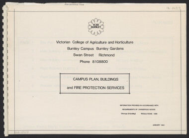 University of Melbourne, Burnley Campus Archives
Plan, Campus Plan, Buildings and Fire Protection Services
site plan, buildings, administration building, plant science laboratories, quad, library, student amenities building, engineering, urban horticulture, nursery -
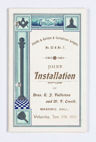 City of Greater Bendigo - Civic Collection
Memorabilia - Invitation and menu card, Joint Installation of Bros. K.J. Fullerton and W. F. Creeth, 1909
Freemasonary or Masonry has its beginnings in local guilds of stonemasons who from the end of 13th century regulated the qualification of stonemasons. Modern Freemasonry uses scriptures which include ritual practices and ethical conduct as part of its foundation and every member must profess a belief in a Supreme Being. Women are not allowed to be admitted and discussion of religion and politics is not to take place within the lodge. Freemasons meet in local Lodges which are supervised at a regional level by a Grand Lodge. The degrees of Freemasonry retain the three grades of medieval craft guilds, those of Entered Apprentice, Journeyman or fellow (now called Fellowcraft), and Master Mason. The candidate of these three degrees is progressively taught the meanings of the symbols of Freemasonry and entrusted with grips, signs, and words to signify to other members that he has been so initiated. The degrees are part allegorical morality play and part lecture. Candidates for Freemasonry will usually have met the most active members of the Lodge they are joining before being elected for initiation. (https://en.wikipedia.org/wiki/Freemasonry) The Golden Lodge of Sandhurst was established as the first Masonic Lodge in Bendigo in 1854. Many prominent men including City Councilors were lodge members at it was a popular way for men to socialise. As the masonic movement expanded further lodges were established in Bendigo and the surrounding Boroughs and Shires. The Golden and Corinthian Lodges purchasing two blocks of land in a prominent position in View Street in 1866 with the intention of erecting a new temple and after amalgamating in 1872 appointed architects Vahland and Getzschmann to design the building. The Bendigo Masonic Hall (now the Capital Theatre) was built in 1873 -74 for both public and private use and contained lodge rooms, a public tavern anda concert hall. The Masonic section occupied the northern side of the building at ground floor level and included a lodge room at the rear, a library and reading room, and other affiliated rooms. Walls of the entry hall and lodge room were decorated with classical columns and panels ornamented with Masonic emblems. The upper level of the building contained a large hall with balcony at the north end and removable stage at the south end. Elaborately decorated with Masonic emblems, this hall was used for Masonic purposes as well as being available to the wider community for social events. The tavern, which became known as the Masonic Hotel, occupied the basement and the ground floor of the southern side of the building and included a sitting room, parlours, billiard room, bedrooms, kitchen, cellars and servants' rooms. It appears that two public entrances were provided for this section, one directly from street level into the basement, the other from the public entry hall. Invitation for the Installation of two Lodge Brothers. Half fold design printed in gold, brown, light blue, dark blue and black ink on white card. Front and back cover decorated with masonic symbols. Menu listed inside. Front cover: Zenith & Golden Corinthian Lodges,/ No. 52 & No. 7./ Joint / Installation / of / Bros. K. J. Fullerton / and W. F Creeth / Masonic Hall / Wednesday, June 30th , 1909 bendigo masonic hall, capital theatre bendigo, milburn catering bendigo, making a nation exhibition, bendigo masonic lodge, city of greater bendigo events, city of greater bendigo community groups -
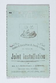 City of Greater Bendigo - Civic Collection
Memorabilia - Invitation and menu card, Joint Installation of Bros. R.T. Trembath and L. A. Sonnenberg, 1910
Freemasonary or Masonry has its beginnings in local guilds of stonemasons who from the end of 13th century regulated the qualification of stonemasons. Modern Freemasonry uses scriptures which include ritual practices and ethical conduct as part of its foundation and every member must profess a belief in a Supreme Being. Women are not allowed to be admitted and discussion of religion and politics is not to take place within the lodge. Freemasons meet in local Lodges which are supervised at a regional level by a Grand Lodge. The degrees of Freemasonry retain the three grades of medieval craft guilds, those of Entered Apprentice, Journeyman or fellow (now called Fellowcraft), and Master Mason. The candidate of these three degrees is progressively taught the meanings of the symbols of Freemasonry and entrusted with grips, signs, and words to signify to other members that he has been so initiated. The degrees are part allegorical morality play and part lecture. Candidates for Freemasonry will usually have met the most active members of the Lodge they are joining before being elected for initiation. (https://en.wikipedia.org/wiki/Freemasonry) The Golden Lodge of Sandhurst was established as the first Masonic Lodge in Bendigo in 1854. Many prominent men including City Councilors were lodge members at it was a popular way for men to socialise. As the masonic movement expanded further lodges were established in Bendigo and the surrounding Boroughs and Shires. The Golden and Corinthian Lodges purchasing two blocks of land in a prominent position in View Street in 1866 with the intention of erecting a new temple and after amalgamating in 1872 appointed architects Vahland and Getzschmann to design the building. The Bendigo Masonic Hall (now the Capital Theatre) was built in 1873 -74 for both public and private use and contained lodge rooms, a public tavern anda concert hall. The Masonic section occupied the northern side of the building at ground floor level and included a lodge room at the rear, a library and reading room, and other affiliated rooms. Walls of the entry hall and lodge room were decorated with classical columns and panels ornamented with Masonic emblems. The upper level of the building contained a large hall with balcony at the north end and removable stage at the south end. Elaborately decorated with Masonic emblems, this hall was used for Masonic purposes as well as being available to the wider community for social events. The tavern, which became known as the Masonic Hotel, occupied the basement and the ground floor of the southern side of the building and included a sitting room, parlours, billiard room, bedrooms, kitchen, cellars and servants' rooms. It appears that two public entrances were provided for this section, one directly from street level into the basement, the other from the public entry hall. Invitation for the Installation of two Lodge Brothers. Horizontal fold printed in black ink on blue card. Embossed cover with scalloped edging. Front and back cover decorated with masonic symbols. Menu listed inside. Front cover: golden & Corinthian & Zenith Lodges / No. 7 and Mo. 52 / joint Installation / of / Bros, R. T. Trembath and L. A. Sonnenber / Masonic Hall, Bendigo / Wednesday, June 29th, 1910. bendigo masonic hall, capital theatre bendigo, milburn catering bendigo, brockley printers bendigo, making a nation exhibition, bendigo masonic lodge, city of greater bendigo community groups, city of greater bendigo events -
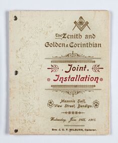 City of Greater Bendigo - Civic Collection
Memorabilia - Invitation and Menu Card, Joint Installation, 1905
Freemasonary or Masonry has its beginning in local guilds of stonemasons which from the end of 13th century regulated the qualification of stonemasons. Modern Freemasonry uses scriptures which include ritual practices and ethical conduct as part of its foundation and every member must profess a belief in a Supreme Being. Women are not allowed to be admitted and discussion of religion and politics is not to take place within the lodge. Freemasons meet in local Lodges which are supervised at a regional level by a Grand Lodge. The degrees of Freemasonry retain the three grades of medieval craft guilds, those of Entered Apprentice, Journeyman or fellow (now called Fellowcraft), and Master Mason. The candidate of these three degrees is progressively taught the meanings of the symbols of Freemasonry and entrusted with grips, signs, and words to signify to other members that he has been so initiated. The degrees are part allegorical morality play and part lecture. Candidates for Freemasonry will usually have met the most active members of the Lodge they are joining before being elected for initiation. (https://en.wikipedia.org/wiki/Freemasonry) The Golden Lodge of Sandhurst was established as the first Masonic Lodge in Bendigo in 1854. Many prominent men including City Councilors were lodge members at it was a popular way for men to socialise. As the masonic movement expanded further lodges were established in Bendigo and the surrounding Boroughs and Shires. The Golden and Corinthian Lodges purchasing two blocks of land in a prominent position in View Street in 1866 with the intention of erecting a new temple and after amalgamating in 1872 appointed architects Vahland and Getzschmann to design the building. The Bendigo Masonic Hall (now the Capital Theatre) was built in 1873 -74 for both public and private use and contained lodge rooms, a public tavern anda concert hall. The Masonic section occupied the northern side of the building at ground floor level and included a lodge room at the rear, a library and reading room, and other affiliated rooms. Walls of the entry hall and lodge room were decorated with classical columns and panels ornamented with Masonic emblems. The upper level of the building contained a large hall with balcony at the north end and removable stage at the south end. Elaborately decorated with Masonic emblems, this hall was used for Masonic purposes as well as being available to the wider community for social events. The tavern, which became known as the Masonic Hotel, occupied the basement and the ground floor of the southern side of the building and included a sitting room, parlours, billiard room, bedrooms, kitchen, cellars and servants' rooms. It appears that two public entrances were provided for this section, one directly from street level into the basement, the other from the public entry hall. Invitation for the Installation of unnamed Brothers. Half fold printed in gold and red ink on cream coloured card. Embossed cover with plain edging. Front and back cover decorated with masonic symbols. Menu listed inside. Front cover: The Zenith and Golden and Corinthian Lodges ? Joint Installation / Masonic Hall, Bendigo / Wednesday, June 28th, 1905 / Bro J.O.R Milburn Caterer bendigo masonic hall, capital theatre bendigo, milburn catering bendigo, making a nation exhibition, james printer eaglehawk, bendigo masonic lodge, city of greater bendigo community groups -
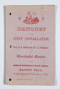 City of Greater Bendigo - Civic Collection
Memorabilia - Invitation, Joint Installation of Bros. R.O. Henderson & T. L. Sargeant, 1906
Freemasonary or Masonry has its beginnings in local guilds of stonemasons who from the end of 13th century regulated the qualification of stonemasons. Modern Freemasonry uses scriptures which include ritual practices and ethical conduct as part of its foundation and every member must profess a belief in a Supreme Being. Women are not allowed to be admitted and discussion of religion and politics is not to take place within the lodge. Freemasons meet in local Lodges which are supervised at a regional level by a Grand Lodge. The degrees of Freemasonry retain the three grades of medieval craft guilds, those of Entered Apprentice, Journeyman or fellow (now called Fellowcraft), and Master Mason. The candidate of these three degrees is progressively taught the meanings of the symbols of Freemasonry and entrusted with grips, signs, and words to signify to other members that he has been so initiated. The degrees are part allegorical morality play and part lecture. Candidates for Freemasonry will usually have met the most active members of the Lodge they are joining before being elected for initiation. (https://en.wikipedia.org/wiki/Freemasonry) The Golden Lodge of Sandhurst was established as the first Masonic Lodge in Bendigo in 1854. Many prominent men including City Councilors were lodge members at it was a popular way for men to socialise. As the masonic movement expanded further lodges were established in Bendigo and the surrounding Boroughs and Shires. The Golden and Corinthian Lodges purchasing two blocks of land in a prominent position in View Street in 1866 with the intention of erecting a new temple and after amalgamating in 1872 appointed architects Vahland and Getzschmann to design the building. The Bendigo Masonic Hall (now the Capital Theatre) was built in 1873 -74 for both public and private use and contained lodge rooms, a public tavern anda concert hall. The Masonic section occupied the northern side of the building at ground floor level and included a lodge room at the rear, a library and reading room, and other affiliated rooms. Walls of the entry hall and lodge room were decorated with classical columns and panels ornamented with Masonic emblems. The upper level of the building contained a large hall with balcony at the north end and removable stage at the south end. Elaborately decorated with Masonic emblems, this hall was used for Masonic purposes as well as being available to the wider community for social events. The tavern, which became known as the Masonic Hotel, occupied the basement and the ground floor of the southern side of the building and included a sitting room, parlours, billiard room, bedrooms, kitchen, cellars and servants' rooms. It appears that two public entrances were provided for this section, one directly from street level into the basement, the other from the public entry hall. Invitation for the Installation of Brothers Henderson and Sargeant. Half fold printed in red ink on grey / mauve coloured card with plain edging. Menu listed inside on left, toasts listed on inside right. Front cover: Banquet / at the / Joint Installation / of / Brox, R. O Henderson & T. L. Sargeant / as / Worshipful Masters / of the / Golden and Corinthian & Zenith Lodges / Masonic Hall / Wednesday, 27th June 1906 bendigo masonic hall, capital theatre bendigo, milburn catering bendigo, making a nation exhibition, brockley printers bendigo, bendigo masonic lodge, city of greater bendigo community groups -
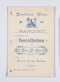 City of Greater Bendigo - Civic Collection
Memorabilia - Invitation, Joint Installation of Bros. H. Lee, 1907
Freemasonary or Masonry has its beginnings in local guilds of stonemasons who from the end of 13th century regulated the qualification of stonemasons. Modern Freemasonry uses scriptures which include ritual practices and ethical conduct as part of its foundation and every member must profess a belief in a Supreme Being. Women are not allowed to be admitted and discussion of religion and politics is not to take place within the lodge. Freemasons meet in local Lodges which are supervised at a regional level by a Grand Lodge. The degrees of Freemasonry retain the three grades of medieval craft guilds, those of Entered Apprentice, Journeyman or fellow (now called Fellowcraft), and Master Mason. The candidate of these three degrees is progressively taught the meanings of the symbols of Freemasonry and entrusted with grips, signs, and words to signify to other members that he has been so initiated. The degrees are part allegorical morality play and part lecture. Candidates for Freemasonry will usually have met the most active members of the Lodge they are joining before being elected for initiation. (https://en.wikipedia.org/wiki/Freemasonry) The Golden Lodge of Sandhurst was established as the first Masonic Lodge in Bendigo in 1854. Many prominent men including City Councilors were lodge members at it was a popular way for men to socialise. As the masonic movement expanded further lodges were established in Bendigo and the surrounding Boroughs and Shires. The Golden and Corinthian Lodges purchasing two blocks of land in a prominent position in View Street in 1866 with the intention of erecting a new temple and after amalgamating in 1872 appointed architects Vahland and Getzschmann to design the building. The Bendigo Masonic Hall (now the Capital Theatre) was built in 1873 -74 for both public and private use and contained lodge rooms, a public tavern anda concert hall. The Masonic section occupied the northern side of the building at ground floor level and included a lodge room at the rear, a library and reading room, and other affiliated rooms. Walls of the entry hall and lodge room were decorated with classical columns and panels ornamented with Masonic emblems. The upper level of the building contained a large hall with balcony at the north end and removable stage at the south end. Elaborately decorated with Masonic emblems, this hall was used for Masonic purposes as well as being available to the wider community for social events. The tavern, which became known as the Masonic Hotel, occupied the basement and the ground floor of the southern side of the building and included a sitting room, parlours, billiard room, bedrooms, kitchen, cellars and servants' rooms. It appears that two public entrances were provided for this section, one directly from street level into the basement, the other from the public entry hall. Invitation for the Installation of Brother Lee. Half fold printed in blue ink on cream coloured card with plain edging. Menu listed inside on left, toasts listed on inside right, officers listed on back cover. Front cover: Sandhurst Lodge / No 194 / Banquet / to celebrate the / Installation / of / Brother H. Lee / in the / Masonic Temple, Bendigo / Thursday, 20th June 1907 bendigo masonic hall, capital theatre bendigo, milburn catering bendigo, making a nation exhibition, bendigo masonic lodge, city of greater bendigo events, city of greater bendigo community groups -
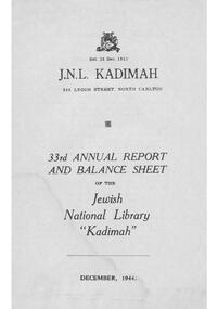 Kadimah Jewish Cultural Centre and National Library
Document - Annual Report, 33rd Annual Report and Balance Sheet of the Kadimah National Library 1944
Annual report produced by Kadimah28 pagesfrom 4th october 1943 to 18th june, 1944. l. fink, a. mushin, j. ginsburg, s. yaffe, miss m. zacharin, s. brilliant, m. bram, h. brown, s. goldstein, i. hurvitz, i. kahan, j. rymer, i. rothman, m. shetzer, j. semel, m. silman, i. sher. b, from 18th june 1944 to 3rd december 1944, j. honig, j. solvey, w. bardas, ph. block, ph. chapman, n. fogel, b. tron, e. wynn, j. l. mendelson, i. segal, s. maranz, j. yoffe -
 Kadimah Jewish Cultural Centre and National Library
Document - Annual Report, 34th Annual Report and Balance Sheet of the Kadimah National Library 1945
Annual report produced by Kadimah32 pagest. ginsburg, s. goldstein, alick mushin, p.h. block, j. solvey, a. braizblat, v. fonda, a. nirens, i. rothman, j. semel, b. tron, h. dorevitch, j. giligitch, s. maranz, m. shechter, n. suchowolski, i. saks -
 Kadimah Jewish Cultural Centre and National Library
Document - Annual Report, 48th Annual Report and Balance Sheet of the Kadimah National Library 1959
Annual report produced by Kadimah44 pagess. burstin, f. altman, n. gryfenberg, h. miodownik, ph. block, mr. b. bargman, h. bachrach, l. cherny, i. czyzyk, i. einhorn, j. gettler, m. greenberg, j. honig, u. kozlowski, b. patkin, s. perlberg, j. rymer, n. smuzyk, e. tabacznik, m. verstandig, m. wilenski, j. engel -
 Kadimah Jewish Cultural Centre and National Library
Document - Annual Report, 49th Annual Report and Balance Sheet of the Kadimah National Library 1960
Annual report produced by Kadimah40 pagess. burstin, f. altman, j. rymer, s. roth, ph. block, n. gryfenberg, l. cherny, i. czyzyk, i. einhorn, b. ezrowicz, j. gettler, g. goldberg, l. gotlib, m. greenberg, u. kozlowski, s. perlberg, ch. rozenbes, h. smith, n. smuzyk, e. tabacznik, m. wilenski -
 Kadimah Jewish Cultural Centre and National Library
Document - Annual Report, 50th Annual Report and Balance Sheet of the Kadimah National Library 1962
Annual report produced by Kadimah52 pagess. burstin, f. altman, j. rymer, l. cherny, i. czyzyk, b. ezrowicz, ph. block, i. einhorn, h. gershov, j. gettler, m. greenberg, n. gryfenberg, a. kwiatkowski, s. powodowski, ch. rozenbes, n. smuzyk, s. szwarc, e tabacznik, s. tigel, m. wilenski, m. zalcman -
 Kadimah Jewish Cultural Centre and National Library
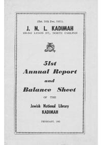
Document - Annual Report, 51st Annual Report and Balance Sheet of the Kadimah National Library 1963
Annual report produced by Kadimah44 pagesj. rymer, ph. block, ch. rozenbes, l. cherny, l czyzyk, f. altman, s. burstin, mr. i. einhorn, b, ezrowicz, h. gershov, m. greenberg, n. gryfenberg, a. kwiatkowski, p. kristal, s. rychter, n. smuzyk, j. sperling, s. szwarc, m. szwarcberg, e. tabacznik, m. wilenski -
 Kadimah Jewish Cultural Centre and National Library
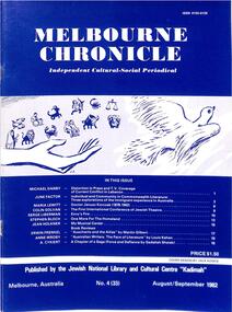
Journal, Kadimah Jewish Cultural Centre and National Library, Melbourner Bleter / Melbourne Chronicle August/September 1982, ADD DATE
Journal published by the Kadimah Jewish Cultural Centre and National Library, Melbourne. Contains essays, reviews, fiction and poetry in both English and Yiddish.48 pages, A4, Softbound, Paper covers. non-fictionJournal published by the Kadimah Jewish Cultural Centre and National Library, Melbourne. Contains essays, reviews, fiction and poetry in both English and Yiddish.moshe ajzenbud, serge liberman, michael danby, june factor, maria lewitt, colin golvan, stephen block, jean holkner, erwin frenkel, anne wroby, a cykiert -
 Melton City Libraries
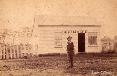
Photograph, William Daley, c.1863
Elizabeth married William Daley. They obtained land on High Street Melton. Their house and bootmaker shop was situated on this block of land. They had two daughters Ann and Elizabeth. Elizabeth had a haberdashery shop and died in 1949. Her sister died in 1933. They are buried at the Melton CemeteryPhotos of Daley in front of his shop and portrait photolocal identities -
 Melton City Libraries
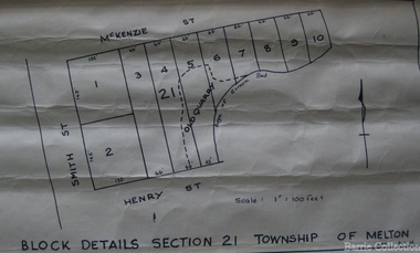
Map, Block details section 21 Township of Melton, 1965
In 1861, Mary Dowling and John Luby obtained Crown Grant land on the corner of Smith and McKenzie Street Melton.Section 21 is covers the block of Smith, Henry and McKenzie Street Meltoncouncil -
City of Kingston
Photograph - Colour, c. 1993
Patterson Lakes is a suburb in the City of Kingston that is built one kilometre upstream of the mouth of the Patterson River. The area is bordered by the Patterson River and Eel Race Drain which enters the Kananook Creek. The suburb consists predominantly of newer housing developments and the tidal canal system of the development joins Port Phillip Bay.Patterson Lakes and the Kananook Creek were previously part of the extensive Carrum Carrum Swamp. The area was once a source of fish and eels for the Mayone-Bulluk clan of the Bunurong people. Over time the area was drained and in 1973 investigations commenced into the development of a unique residential area that would be built adjacent to canals and waterways. It was originally proposed to be known as "Gladesville". The development would give the suburb's homeowners access to Port Phillip Bay "from their back door". Circa 1974, the area was rezoned from rural to residential and named Patterson Lakes. Development has been continuous since the 1970s with construction of residential housing, schools, shopping centres, marinas, a hotel and library.Laminated colour aerial photograph of the Carrum and Patterson Lakes region within City of Kingston. This 1993 image includes Patterson River Secondary College, Roy Dore Reserve, Kananook Creek and Nepean Highway. The railway line can be seen as it veers inland from Eel Race Road, Seaford. The section of Palm Beach Drive, Curlew Point Drive, Snapper Point Drive, Clipper Island and Myola Street in Patterson Lakes appears to be a recent development with many spare blocks and new houses under construction.patterson lakes, seaford, kananook creek, carrum carrum swamp, canals and waterways -
City of Kingston
Photograph - Colour, 6 March 1993
Edithvale is a suburb in the City of Kingston. It is located between Aspendale and Chelsea on the Port Phillip Bay and built within remnant areas of the Carrum Carrum swamp. The foreshore precinct comprises a wide sandy beach, with low sand dunes and numerous historic boat sheds. The suburb consists of older style dwellings and former holiday houses, combined with mid-century housing and newer homes. The large blocks are increasingly subdivided and the existing dwellings demolished to accommodate units and townhouses, thus changing the landscape of the area and reducing the tree canopy.The beachside suburb of Edithvale was previously part of the extensive Carrum Carrum Swamp. The area was once a source of fish and eels for the Mayone-Bulluk clan of the Bunurong people. Over time the area was drained and predominantly devoted to dairy farming and holiday houses. The farms were gradually sold and subdivided with a large number of homes built after World War II and in the 1960s. Edithvale is mainly residential with a shopping strip along Nepean Highway but little significant industry was ever established in the area apart from a plaster works and confectionary factory, both now closed.Laminated aerial colour photograph of Edithvale as viewed from Alexandra Avenue in the north to Ella Grove Chelsea/Edithvale in the south. regents Park Aspendale can be seen in the top left. The area is built-up with residential housing and facilities including Edithvale Primary School, numerous churches and the Edithvale Railway station. Large sections depict the remnant Carrum Carrum swamp. Edithvale Common and the former "Duck Inn" (Melbourne Water/Friends of Edithvale Seaford Wetlands) can be seen. Edithvale Recreational reserve, the valodrome and Edithvale Public Golf Course are prominent. The image shows vacant land in the area now known as Aspendale Gardens and the newer residential section of Chelsea Heights is not developed. A bike path has been established to cover the secondary drain. The Golf Links Court residential development located off Hughes Avenue is a large vacant block.Black type on white adhesive label: 6-3-93 Black type on white adhesive label: 25/9211, 6/3/93, 11.20 am Black type on white adhesive label: 9211 Yellow circular adhesive sticker Black pencil: 9211 6-3-93 arrow pointing Nedthvale, carrum carrum swamp, aspendale, chelsea -
City of Kingston
Photograph - Black and white, 20 December 1945
This aerial image covers a section of Cheltenham, with a large paddock yet to be converted to an industrial and later a commercial zone.This aerial photograph provides evidence of the changing landscape of Cheltenham and Highett since WWII. Photographed in 1945, the image features a large block of land now the site of site the major transformation of Cheltenham with the development of the Southland shopping centre in the 1960s and expansion in the 1990s.Aerial photograph of the Cheltenham area in the City of Kingston. This 1945 image is concentrated on the area between Bay Road and Garfield Lane with the distinctive bend into Jean Street. A large block of land runs between the Nepean Highway and the rail line. This is now the area occupied by the extension of Southland in the 1990s.cheltenham, southland, aerial photograph, highett -
City of Kingston
Photograph - Black and white, 20 December 1945
This aerial image covers a section of Cheltenham, with a large paddock yet to be converted to an industrial and later a commercial zone.This aerial photograph provides evidence of the changing landscape of Cheltenham and Highett since WWII. Photographed in 1945, the image features a large block of land now the site of site the major transformation of Cheltenham with the development of the Southland shopping centre in the 1960s and expansion in the 1990s.Aerial photograph of the Cheltenham area in the City of Kingston. This 1945 image is concentrated on the area between Bay Road and Garfield Lane with the distinctive bend into Jean Street. A large block of land runs between the Nepean Highway and the rail line. This is now the area occupied by the extension of Southland in the 1990s. It is a negative version of VKHC124.cheltenham, southland, market garden -
 City of Kingston
Pamphlet - Colour, W. H. Wood Estate Agent, Subdivisional Land Auction Barker's Estate Cheltenham, 1919
Sales plan for land in the suburb of Cheltenham, along Barker StreetThe developing urban area of Cheltenham within the City of Kingston. This land sale pamphlet illustrates the subdivision of land within the municipality and the changing demographic of the district as new houses are constructed.Colour pamphlet advertising subdivisional land auction of Barker's estate, on Barker Street Cheltenham.Handwritten in grey pencil on the subdivision map: a series of numbers on each block possibly indicating the sale price. Handwritten in grey pencil on the subdivision map: Roy- joined to subdivision 6 Handwritten in grey pencil on the subdivision map: x on the border between subdivision 17 and 16, and again on the border between subdivision 12 and 11.cheltenham, land sales, estate