Showing 5778 items
matching location
-
 Ringwood and District Historical Society
Letters, Heatherdale Pre-School Association: Building Opening, General letters, building permits etc. 1953, 1951-2
Heatherdale Pre-School Association. First year of operation 1953. Location Yallourn Parade, Ringwood. Building Opening.Documents from Heatherdale Pre-School Association. Building Opening. Letters General plus 1952 Fair. Building permits. Equipment requirements. First year of operation 1953. Location Yallourn Parade, Ringwood.File and Letters -
 Surrey Hills Historical Society Collection
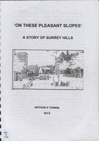
Book, On these pleasant slope's: a story of Surrey Hills, 2015
Sourced via conversations with those interested in Surrey Hills History. Including Alan Holt, Jack McLean, Frank Bamford, Jocelyn Hall. Includes: Topographical maps, first Elgar Survey. First Wesleyan Church in Surrey Hills. Bibliography on P.50 (last numbered page) Provides a chronological history of Surrey Hills. Includes: First settlers, location, early land sales, commerce and trade.Provides a chronological history of Surrey Hills. Includes: First settlers, location, early land sales, commerce and trade.Back of Title page: To the Surrey Hills Historical / Arthur E. Tonkinfreehold investment and banking company, windsor park estate, (mr) dennis delany, mont albert village, surrey hills - history, royal hotel, surrey hills, humberstone's hotel, chatham state school, holy trinity church, lydswood, lugano, (mr) john butler maling, (mr) john hanlon knipe, mont albert primary school, (mr) james sneddon, (mr) arthur tonkin -
Ringwood and District Historical Society
Letters, Heatherdale Pre-School Association: Building Opening and First Year of Operation. Documents 1952-1953, 1952-3
Heatherdale Pre-School Association. First year of operation 1953. Location Yallourn Parade, Ringwood. Building Opening.Documents from Heatherdale Pre-School Association. Building Opening. Letters General Oct-1952 to Feb-1953. First year of operation 1953. Location Yallourn Parade, Ringwood. Contains 'Definition of a Nursery Kindergarten.'File and Letters -
 Australian Commando Association - Victoria
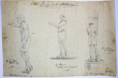
Work on paper - Sketch, Corporal Francis John Papworth, Some Independent Attitudes - Katherine 1942, June-July 1942
Drawing done on location by Francis John 'Curly' Papworth whilst serving in Katherine, Northern Territory during World War Two. This work of soldiers is significant as a work produced by a serving soldier on location during WWII and is a unique example of an artistic work showing the men and their surroundings at the time. Strong provenance as part of the family collection. Pencil sketch on white paper of three bare chested male figures, two left profile and one rear view. All attired in shorts and boots. Information relating to the figures and location are written on the work. Signature right hand corner: Papworth 42. Written in pencil at top of page: Some Independent Attitudes/Katherine N.T. 1942, June/July Working in the Q Store. Beneath each figure written in pencil and ink left to right: Figure 1: Maj Percy Black Adamsom Esq. (in blue ink below: Perc Adamson Dec) Figure 2: Reg Moggins, working on his Birthday too! (in blue ink below: ?) Figure 3: You can't mistake this one either! (in blue ink below: Con Nugent, Dec)soldiers, wwii, world war 2, second world war, artists, wartime, francis john papworth -
 Greensborough Historical Society
Business Card, Clements Avenue Automotive, Clements Avenue Automotive, Bundoora, 2018c
Clements Avenue Automotive is an automobile repair and service business in BundooraBusiness card, printed in colour both sidesLocation map, contact detailsautomotive repairs, bundoora, clements avenue bundoora -
 Greensborough Historical Society
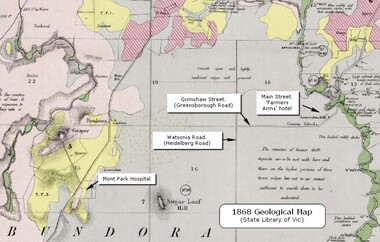
Map - Geological Map, 1868 Geological map of Greensborough (annotated), 1868_
This geological map from the State Library of Victoria collection has been annotated by GHS member Ian Bryant to show some local landmarksDigital copy of colour map.Annotations on map show locations.greensborough - maps, 1860s melbourne, suburbs, geography, roads -
 Federation University Historical Collection
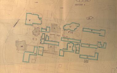
Plan - Site Plan, Mount Helen Campus Academic area
Federation University site plan made for the Ballarat College of Advanced Education Printed architectural plan of the Mount Helen campusprinted with location names and symbolssite plan, federation university, ballarat college of advanced education, mount helen campus, campus plan -
Tatura Irrigation & Wartime Camps Museum
Photograph - coloured, Irrigation Research Institute Staff 1985, 1985
Staff photograph of Irrigation Research Institute October 1985Coloured photograph in wooden varnished frame. 73 people. Trees and buildings in background. Peoples names included along base of photograph. Glass cover in frame.Names of people, date and location.irrigation research institute -
 Stawell Historical Society Inc
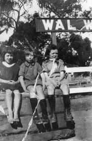
Photograph, Miss Lavis Dunn & Miss Gladys Dunn with their cousin Miss Lorna Dunn in Wal Wal
Snapshot of Lavis & Gladys Dunn with their cousin Lorna Dunn at Wal WalLocation and names on back of Photostawell -
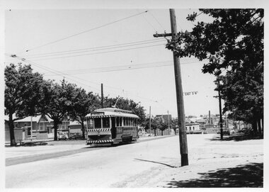
 Melbourne Tram Museum
Photograph - Albert Road and Clarendon St South Melbourne, Bill Kingsley, 13/10/1971
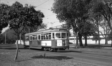
Set of four black and white photos by Bill Kingsley of trams in South Melbourne: 1 - SW6 895 (Sth Melbourne & St Kilda Beach, Route 12) outbound in Albert Road. Tram has advertisements for Robo 2 min auto car wash, and Norton makes Bear Tape. 2 - W2 639 (Sth Melbourne & St Kilda Beach, Route 12) outbound in Albert Road. Tram has advertisements for Tolleys Brandy. In the background is the former South Melbourne Football ground. 3 - W5 773 (City-Brunswick St, route 12), turning from Albert Road into Clarendon St. Tram has advertisements for Sprint soft drink and HMV sound systems. 4 - Photo of Bill KIngsley's well-known VR Combi van.Yields information about the Albert Road tram servicesSet of four black and white photographs and associated 35mm negatives.Location on the rear of each print.trams, tramways, bill kingsley., albert road, clarendon st, route 12, sw6 class, w5 class, w2 class, tram 895, tram 639, tram 773, vr combi, south melbourne, south melbourne football ground -
 Ringwood and District Historical Society
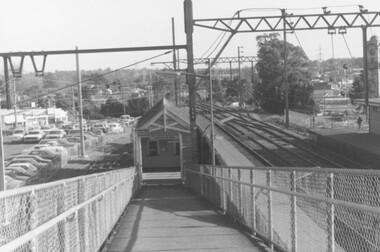
Photograph, Ringwood Railway Station - ramp leading down to No. 2 platform looking west, combined with the station car park bordering Station St
Black and White PhotographDesciption of location on rear of photo -
 Ringwood and District Historical Society
Map, Plan of Country Lands in the Parishes of Nunawading Ringwood and Scoresby - circa 1855
Blueprint copy of Survey Map detailing original Selectors' names and property locations. List of Parish map references including property bearings, distances in Links, and markings on trees. Descriptive remarks include areas marked "Farmer's Common", "Poor soil thickly/moderately timbered with stringy bark", and location of water and firewood reserves."Surveyed and plotted by N.M. Bickford, Superintendant of Mr. Hodgkinson's Field Party". "The land comprised in this survey is of inferior quality, moderately undulating, and thickly wooded. It is watered by Dandenong Creek and Deep Creek." Inset map showing location of (*proposed) cemetery on southern corner of Lillydale Road from Melbourne and Sawmill Road, later Mount Dandenong Road. (*Cemetery did not eventuate.) -
4th/19th Prince of Wales's Light Horse Regiment Unit History Room
Post cards, J Williams, c. 1918
Five black & white post card pictures showing parts of the Western Front. They are: 1. Peronne - Aspects of the town entirely destroyed by the retreating Germans, 2. The village of Feuilleres (Somme) (destroyed) , 3. Estrees (Somme) - Entrance of the village, 4. Neuve Eglise (destroyed) and, 5. La Buissiere, La Gare1,2,&3 Vise Paris No 853, 867 & 863 and description of location. 4 & 5 - location onlyphotos, western front -
 Parks Victoria - Wilsons Promontory Lightstation
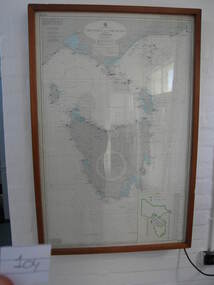
Nautical chart
Used as display in AMSA workshop foyer, Moorabbin, Vic. Nautical charts x 2 , The framed and glazed chart identifies strategic points in the notorious Bass Strait passage, which in the nineteenth century was known as the ‘Eye of the Needle’. It covers the whole of Tasmania, Bass Strait and the islands, and the lower part of Victoria with its coastline between Cape Otway and Gabo Island. The chart has an electric cord connecting it to a wall switch which enables a series of small lights to flash on strategic geographical locations.. While it is not known if it is original to Wilsons Promontory, it certainly elates to its location. A similar chart at Cape Otway shows less of Tasmania and is not electrified. Gabo Island Lightstation has two large framed charts; one is the same as the Wilsons Promontory example but without the lights and the other is entirely different, focussing on the east coast between Point Hicks and Montague Island. The Wilsons Promontory chart is unique as an illuminated version of the other charts and has first level significance if its provenance to the lightstation can be confirmed.The framed and glazed chart has an electric cord connecting it to a wall switch which enables a series of small lights to flash on strategic geographical locations.Yes -
 Greensborough Historical Society
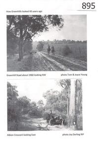
Photograph, Greenhills circa 1960, 1960c
The Greenhills area of Greensborough is now a suburban area. These photographs, taken in the 1960s, show it as open bush and farmland. Greenhills is designated a 'semi-bush precinct' by Banyule Council, due to its vegetation and large blocks of land.Copies of 4 black and white photographs.Captions identify each location and the photographer.greenhills, semi-bush precinct, tom young, joy darling, greenhill road, albion crescent -
 Bendigo Military Museum
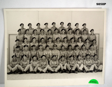
Photograph
Unidentified Army unit in a posed photograph c.1950's.Black and white photo of a platoon of Australian Soldiers of an unidentified unit. Possibly National Service given the age profile. On the back is a list of names (15 No.) out of 52 soldiers in the photo. The names look like signatures of individuals in question.15 signatures on back, some with location.photograph, army unit -
Ringwood and District Historical Society
Newspaper Clipping, New Home Found for History Marker, 5-Jun-07
New home found for historical marker. Newspaper article covering the move of a historical marker of the Borough of Ringwood to the Shire Offices precinct. View of marker in its new/final location.New home found for historical marker. Newspaper article covering the move of an historical marker of the Borough of Ringwood to the Shire Offices precinct. View of marker in its new/final location. +Additional Keywords: Gurr, Peter / Haines, RussBorough of Ringwood -
Whitehorse Historical Society Inc.
Document, Nunawading and District local government records
Records of the municipalities of Nunawading and Box Hill districtsRecords of the municipalities of Nunawading and Box Hill districts from Road District 1857 through to City of Nunawading 1994 and lists of location of records for each period within the Public Record Office. Extracts from PRO lists of holdings.Records of the municipalities of Nunawading and Box Hill districts local government, nunawading road district, shire of nunawading, borough of box hill, city of box hill, shire of blackburn and mitcham, city of nunawading, victoria. public record office -
Stawell Historical Society Inc
Map, Gold Mines of Australia, Plan of Stawell Goldfield. Mining Leases, 1952
And Shaft Locations 1952 G G Birch Mining Surveyormining, gold, map -
 Bendigo Historical Society Inc.
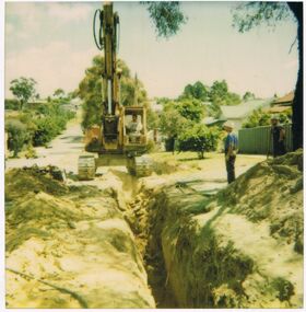
Photograph - CASTLEMAINE GAS COMPANY COLLECTION: PHOTO EXCAVATION
Excavation at Unknown LocationPolaroidorganisation, industry, gas and fuel -
 Ballarat Tramway Museum
Photograph - Colour print, A T Miles, Lake Wendouree and Mount Warrenheip, 30-1-1968
Colour photograph of a single truck tram east bound in Wendouree Parade near St Aidans Drive with the lake and Mount Warrenheip in the view. Taken by A T Miles 31-1-1968.Yields information about the Ballarat Tramway operations and views during 1968.Photograph - colour print with notes on rear.A T Miles stamp and location and date notes.tramways, trams, lake wendouree, wendouree parade, mt warrenheip -
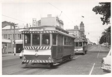 Ballarat Tramway Museum
Photograph - Black and White - trams 26 and 33 City Loop Sturt St, A T Miles, Nov. 1969
Black and white photograph of trams 26 (Mt Pleasant) and 33 (City) parked in the City Loop Sturt Street. No. 33 has a Twin Lakes sign. Taken by A T Miles Nov. 1969.Yields information about the Ballarat Tramway operations and views during 1969.Photograph - black and white print with notes on rear.A T Miles stamp and location and date notes.tramways, trams, sturt st, city loop, tram 26, tram 33 -
 Ballarat Tramway Museum
Photograph - Black and White - tram 40 in the City Loop, A T Miles, Nov. 1969
Black and White - tram 40 in the City Loop at the eastern end of Sturt St. Trams were parked in the loop during the day between peak periods rather than run them back to the depot. Taken by A T Miles Nov. 1969.Yields information about the Ballarat Tramway operations and views during 1969.Photograph - black and white print with notes on rear.A T Miles stamp and location and date notes.tramways, trams, sturt st, city loop, tram 40 -
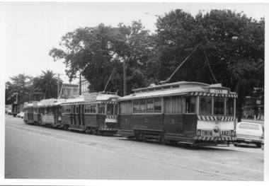 Ballarat Tramway Museum
Photograph - Black and White - four trams in the City Loop, A T Miles, Nov. 1969
Black and White - four trams in the City Loop at the eastern end of Sturt St, including tram 33 and the Santa Tram. Trams were parked in the loop during the day between peak periods rather than run them back to the depot. Taken by A T Miles Nov. 1969.Yields information about the Ballarat Tramway operations and views during 1969.Photograph - black and white print with notes on rear.A T Miles stamp and location and date notes.tramways, trams, sturt st, city loop, tram 33, santa tram -
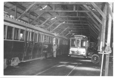 Ballarat Tramway Museum
Photograph - Black and White - SEC tram depot interior view, A T Miles, Nov. 1969
Black and White - SEC tram depot interior view with a former Hawthorn Tramways Trust tramcar and a single truck car in the view, along with a set of wheels. Taken by A T Miles Nov. 1969.Yields information about the Ballarat Tramway depot interior during 1969.Photograph - black and white print with notes on rear.A T Miles stamp and location and date notes.tramways, trams, sec depot, htt -
 Ballarat Tramway Museum
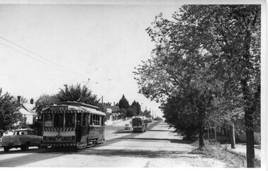
Photograph - Black and White - Lydiard St North - trams 14 & 43, A T Miles, 30/1/1968
Black and White - tram 14 north bound to Lydiard St North, followed by tram 43, also showing Lydiard St North.. Taken by A T Miles 30/1/1968.Yields information about tram services in Lydiard St North.Photograph - black and white print with notes on rear.A T Miles stamp and location and date notes.tramways, trams, lydiard st north, tram 14, tram 43 -
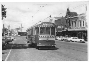
 Ballarat Tramway Museum
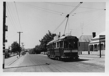
Photograph - Black and White - tram 39 - Mt Pleasant terminus, A T Miles, 30/1/1968
Black and White - tram 39 at the Mt Pleasant terminus. Has the "Cars Stop Here", and "End of Section" signs on a pole on the left hand side of the photograph. Taken by A T Miles 30/1/1968.Yields information about the Mt Pleasant terminus.Photograph - black and white print with notes on rear. Printed on Ilford paper.A T Miles stamp and location and date notes.tramways, trams, mt pleasant, tram 39 -
 Ballarat Tramway Museum
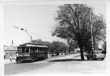
Photograph - Black and White - tram 12, Victoria St terminus, A T Miles, 30/1/1968
Black and White - tram 12 at the Victorian St terminus. Has the "Cars Stop Here", and "End of Section" signs on a pole on the right hand side of the photograph. In the background is Meaghers Hotel. A crewman is walking around the tram after turning the pole. Taken by A T Miles 30/1/1968.Yields information about the Victorian St terminus.Photograph - black and white print with notes on rear. Printed on Ilford paper.A T Miles stamp and location and date notes.tramways, trams, victoria st, tram 12, meaghers hotel, hotels, signs -
 Ballarat Tramway Museum
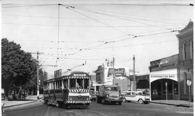
Photograph - Black and White - tram 41 - Hospital Corner, A T Miles, 30/1/1968
Black and White - tram 41 (Sebastopol) turning from Sturt St into Drummond St South. Has the "Cars Stop Here", and "End of Section" signs on a pole on the left hand side of the photograph. In the background is Rimmington Bros Butchers, J A Malpass and a sign for Marshall batteries. Shows the driver looking back through the windows for traffic. Taken by A T Miles 30/1/1968.Yields information about the intersection of Sturt St and Drummond St - Hospital Corner.Photograph - black and white print with notes on rear. A T Miles stamp and location and date notes.tramways, trams, tram 41, hospital corner, sturt st, drummond st south -
 Ballarat Tramway Museum
Photograph - Black and White - tram 17 Victoria St and East St, A T Miles, 30/1/1968
Black and White - tram 17 (Victoria St) at the intersection with East St, looking west. Shows the curve in Victoria St, just before the descent to Bridge St, Taken by A T Miles 30/1/1968.Yields information about the Victoria St route.Photograph - black and white print with notes on rear. Printed on Ilford paper.A T Miles stamp and location and date notes.tramways, trams, tram 17, victoria st, east st