Showing 1465 items
matching looking east
-
 Stawell Historical Society Inc
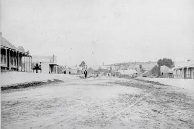
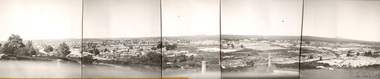
Photograph, Upper Main Street Reefs looking East towards Big Hill from the front of Joyce's Hibernian Hotel 1866
... Upper Main Street Reefs looking East towards Big Hill from...Upper Main Street Reefs looking East towards Big Hill taken...Upper Main Street Reefs looking East towards Big Hill taken ...Upper Main Street Reefs looking East towards Big Hill taken from front of Joyce's Hibernian Hotel . Part of a collection of Photographs by Mr. O.G. Armstrong as commissioned by the Shire of Stawell for the Inter-colonial and Paris Exhibition in Melbourne in 1866. This scene was taken in 1866 in Main Street from in front of Joyce’s Iberian Hotel on the left, the site of the present townhall. It is looking uphill and eastward with Big Hill in the far background. The Hibernian Hotel was built on Commercial Street Pleasant Creek Goldfields in 1858 and was moved to Main Street Reefs, the present site of the Town Hall by Mr. & Mrs. Joyce. It was later destroyed by fire and the Town Hall built on its location. Street scene with buildings in distance and Big Hill in far distance.stawell streetscape -
 Melbourne Tram Museum
Photograph - Digital Image, Kevin O'Reilly, St Kilda looking east over St Kilda Junction, late 1925
... St Kilda looking east over St Kilda Junction... Reg Item 135. Image titled "St Kilda" on CD, of looking... Kilda" on CD, of looking east over St Kilda Junction from. Has ...Image from CD (Compact Diskette for use in computers) - see Reg Item 135. Image titled "St Kilda" on CD, of looking east over St Kilda Junction from. Has St Kilda tramway Jtn (St Kilda Road, Fitzroy St, Barkly St, Brighton Road, Wellington St and Punt Road in the photograph, and the "Junction Oval". Mid to late 1925 as workmen are converting the cable track in Fitzroy St and Wellington St looks or appears converted with a crossover installed near the junction. Two cable car sets visible in St Kilda Road, on in Brighton Road and a bus? Also a bus? in Fitzroy St.trams, tramways, st kilda junction, st kilda railway station, fitzroy st, brighton rd, cable trams -
 Stawell Historical Society Inc
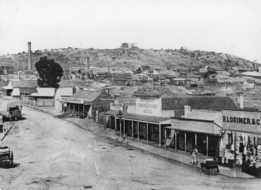
Photograph, Streetscape of South side of Upper Main Street Reefs Stawell looking East from around Patrick Street corner with Big Hill Mining in background c 1867
... Stawell looking East from around Patrick Street corner with Big...Upper Main Street east of Patrick street, looking East c...Upper Main Street east of Patrick street, looking East c ...Upper Main Street east of Patrick street, looking East c 1867 with Big Hill Mining in Background. J McGee's Shamrock Hotel. Jennings Western Turf Hotel. R Lorimer & Co. Photo c 1867 McGees Shamrock Hotel centre. R. Williams Dining Rooms,. Jennings's Western Turf Hotel situated in upper Main Street (Opposite Monaghan's Estate Office) Mr. George Jennings was proprietor until the late 1860's when he went to live at "Mayo Park" Lubek. The Hotel had Various owners until it was delicensed in 1909 and became a boarding house. It was demolished in 1921. R. Lorimer & Co general Store near corner of Patrick Street.Streetscape of South Side of Main Street East of Patrick Street. Two wagons in street. Showing J. McGees Shamrock Hotel, R Williams Dining Rooms, Jennings's Western Turf Hotel and R. Lorimer & Co. Mine Engine Chimney is on left of photo. Big Hill in Background with Waterloo Reef Company Whim at centre.stawell streetscape -
 Ballarat Heritage Services
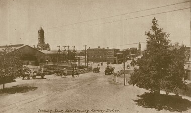
Photograph - Image, Looking South East Showing the Ballarat Railway Station
... Looking South East Showing the Ballarat Railway Station...Ballarat looking South East from the Ballarat Railway... Ballarat looking South East from the Ballarat Railway Station ...Ballarat looking South East from the Ballarat Railway Station. ballarat railway station, ballarat railway gates, lydiard street ballarat, reid's coffee palace, lydiard street north -
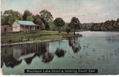 Whitehorse Historical Society Inc.
Postcard - Coloured postcard, Blackburn Lake, Blackburn looking South East. 1906, 1906
... Blackburn Lake, Blackburn looking South East. 1906..., looking South East'.... Postcard entitled 'Blackburn Lake, Victoria, looking South East ...Coloured Postcard entitled 'Blackburn Lake, Victoria, looking South East'.luke, mrs, blackburn lake sanctuary -
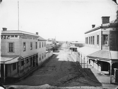 Stawell Historical Society Inc
Photograph, Main Street & Patrick Streets corner looking East down Patrick Street with the Foresters Hotel on left corner 1878
... Main Street & Patrick Streets corner looking East down... looking East down Patrick Street. Weatherboard Foresters Hotel... looking East down Patrick Street. Weatherboard Foresters Hotel ...First floor view from corner of Main & Patrick Streets looking East down Patrick Street. Weatherboard Foresters Hotel in Main Street on left corner. Foresters Hotel was built in 1868 by Mr. Joseph Cawley, Mr. and Mrs. Cawley were the occupants for 30 years. The site was previously occupied by a Billiards Room. In 1917 the building became Foresters Coffee Palace with new owner Mr. J.C. Crothers who purchased the building for 410 pounds and leased it to Mr. Robert Wennerbom. The next lease holder was Miss Fulton and in 1921 Mrs. R. Claringbold took over and called the building Foresters House. The building was sold in 1935 and demolished shortly after sale. Businesses visible down Patrick street, Foresters Hotel, J.H. Wallis Royal Exchange Hotel on Big Hillside of Street. With St Patrick's church tower visible in distance. Melbourne Cash Store Wines and Spirits on corner of Patrick and Sloane Street near centre of photo. Ferns Hotel / Times office on right of photo, corner of Patrick and Main Street. Post Box on Corner at right of photo. 1878First floor view from Main Street Patrick Street intersection looking down Patrick Street. Foresters Hotel on left. Fern Boarding House on right.Victorian Views. C. Herbert, Photo. Stawell 1878stawell businesses streetscape -
 Brimbank City Council Art Collection
Photograph, Robert Pointon, Kororoit Creek looking North east, 1993
... Kororoit Creek looking North east ...Kororoit Creek looking North east with the Albion explosive... Scene Kororoit Creek looking North east with the Albion ...Local SceneKororoit Creek looking North east with the Albion explosive site in the background - AR0020 -
 Ballarat Heritage Services
Photograph, Ballarat Looking North-east from the Town Hall Tower, 14/12/1895
... Ballarat Looking North-east from the Town Hall Tower... Looking North-east from the Town Hall Tower... in the Australasian of Ballarat Looking North-east from the Town Hall Tower ...Photograph published in the Australasian of Ballarat Looking North-east from the Town Hall Towerballarat, ballarat town hall, ballarat post office, ballarat railway station -
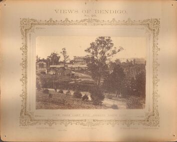 Bendigo Historical Society Inc.
Photograph - VIEWS OF BENDIGO: FROM CAMP HILL LOOKING NORTH EAST, c. 1870s
... VIEWS OF BENDIGO: FROM CAMP HILL LOOKING NORTH EAST..., looking North East. Printed on front below photo: Welch Type... photograph of view from Camp Hill, looking North East. Printed ...Photograph No. 25. Sepia photograph of view from Camp Hill, looking North East. Printed on front below photo: Welch Type, Corporation High School, Police Office, County Court House, St Killian's R.C. Church, Forbes & Holmes, Agents. Purple RHS of Victoria, Bendigo Branch, 1949, 169. Stamped and written on back. Nicholas CaireN.J. Caire - Sandhurstcottage, miners -
 Federation University Historical Collection
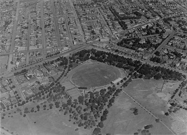
Photograph (Black & White), Keith E. Rash, Ballarat From Sovereign Hill Looking East, 1951
... Ballarat From Sovereign Hill Looking East... Sovereign Hill and look towards the South East. Geelong Road.... Ballarat From Sovereign Hill Looking East Photograph (Black & White ...Keith Rash was highly involved in research relating to Ballarat. He took this photo in the Gold centenary year.Six small black and white photographs have been taped together to form a panorama of Ballarat. The Photos were taken from Sovereign Hill and look towards the South East. Geelong Road is evident in the foreground. In the centre of the panorama is Mt Warrenheip, and to the right is Mt Buninyong. Stamped lower right 'K.E.Rash'ballarat, sovereign hill, ballarat east, keith rash, mount buninyong, mount warrenheip -
 Bendigo Historical Society Inc.
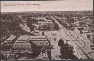
Postcard - Sepia Postcard of old Bendigo
... Bendigo looking east along Pall Mall taken from the Post...Sepia postcard of old Bendigo - detailed as "Looking East... Collection Bendigo looking east along Pall Mall taken from the Post ...BHS CollectionSepia postcard of old Bendigo - detailed as "Looking East from Post Office, Bendigo"; taken from the Post Office tower. Rear is unstamped - therefore not posted. Personal message addressed to Dear Addie from Fred (!!) acknowledges a short holiday in Bendigo.bendigo looking east along pall mall taken from the post office tower., aerial view towards east bendigo -
 Greensborough Historical Society
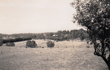
Photograph - Digital Image, Cherel Sartori, Looking east from Henry Street to the river 1956, 01/01/1956
... Looking east from Henry Street to the river 1956...Looking from Henry Street east to the Plenty River, 1956... Plenty Lower Plenty melbourne Looking from Henry Street east ...Looking from Henry Street east to the Plenty River, 1956. The house was built 1917, at 112 Henry Street Greensborough by William Mitchell on the 60 acre dairy farm owned by Ethel and Walter Kell. This collection of photographs was copied by Cherel Sartori (who owned the house from 1990-2000), following a visit by Claude Amiet who lived in the house as a child in the early 20th century.An indication of the rural aspect of this area in the mid-20th century.Digital copy of black and white photographkell's cottage, claude amiet, cherel sartori -
 Ringwood and District Historical Society
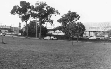
Photograph, Looking south-east from Staley Reserve 1981
... Looking south-east from Staley Reserve 1981...Written on back of photograph, "6/6/81. Looking south-east.../6/81. Looking south-east from Staley Reserve." View shows ...View shows Ringwood Disposals, Guests Furniture and Clock TowerWritten on back of photograph, "6/6/81. Looking south-east from Staley Reserve." -
 Tatura Irrigation & Wartime Camps Museum
Photograph - original, Hogan Street Tatura 1932, 1932
... , looking east. 1932....on back: Tatura, Hogan Street. looking east 1932. from.... looking east 1932. from corner - Youngs Cafe. Black and white ...Photograph showing Hogan street, Tatura in 1932. Showing telegraph poles, palm tree, big tree, fence and residence of Youngs cafe.Black and white original photograph of Hogan Street, Tatura, looking east. 1932.on back: Tatura, Hogan Street. looking east 1932. from corner - Youngs Cafe.hogan street tatura -
 Ringwood and District Historical Society
Photograph, Intersection of Warrandyte Road and Oban Road, North Ringwood. Looking south-east. 1981
... Ringwood. Looking south-east. 1981... of Warrandyte Road and Oban Road. Looking south-east"..... Looking south-east". Intersection of Warrandyte Road and Oban Road ...Written on back of photograph, "18/4/81. Intersection of Warrandyte Road and Oban Road. Looking south-east". -
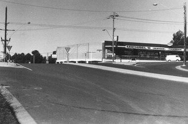
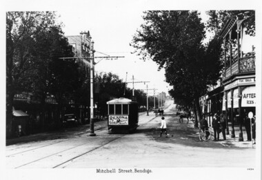 Bendigo Tramways (managed by the Bendigo Heritage Attractions)
Black and White Photograph, Mitchell Street Bendigo. circa 1905, circa 1905
... Street view, looking East along Mitchell Street Bendigo...Mitchell street Bendigo, looking east...., looking east. Mitchell Street Bendigo. circa 1905 Black and White ...Street view, looking East along Mitchell Street BendigoMitchell street Bendigo, looking east. -
 Ringwood and District Historical Society
Photograph, View from Loughnan's Hill looking south east - c.1946
... View from Loughnan's Hill looking south east - c.1946....View from Loughnan's Hill looking south east - 1946... Road Ringwood North melbourne View from Loughnan's Hill looking ...View from Loughnan's Hill looking south east - 1946. Written on back of photograph, "Smoke on left from Bamford's Timber Yard". -
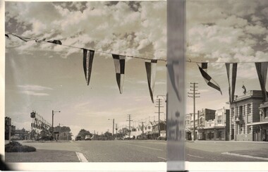 Whitehorse Historical Society Inc.
Photograph, Royal Visit 1954
... Royal visit 1954 showing street decorations looking East....Whitehorse Road Looking East showing bunting in Mitcham... looking East. Maroondah Highway Mitcham Royal visit 1954 ...Royal visit 1954 showing street decorations looking East.Whitehorse Road Looking East showing bunting in Mitchammaroondah highway mitcham, royal visit 1954, decorations -
 Ringwood and District Historical Society
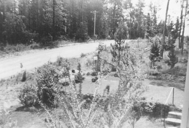
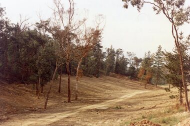
Photograph, View of Glenvale Road near top of first hill from bridge looking north east 1964
... looking north east 1964... of Glenvale Road near top of first hill from bridge looking north east... from bridge looking north east. Original supplied by Garrett ...See Also #25Written on back of photograph, "Copy of a 1964 view of Glenvale Road near top of first hill from bridge looking north east. Original supplied by Garrett Gundry." -
 Ringwood and District Historical Society
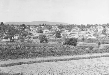
Photograph, New housing developments, New Street, 1960 viewed from railway line near Madden Street looking south-east
... railway line near Madden Street looking south-east.... Street, 1960. From railway line near Madden Street looking south... near Madden Street looking south-east. Dam centre foreground ...Written on back of photograph, "New housing settlement New Street, 1960. From railway line near Madden Street looking south-east. Dam centre foreground". -
 Ringwood and District Historical Society
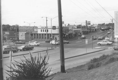
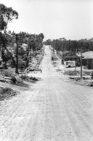
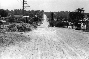
Photograph, Maroondah Highway East, Ringwood- 1976. Looking east from Warrandyte Road intersection
... Maroondah Highway East, Ringwood- 1976. Looking east from...- 1976. Looking east from Warrandyte Road intersection ...Black and white photographImage shows intersection with C.B.A. Bank on north east corner. Photograph taken mid 1976. -
 Ringwood and District Historical Society
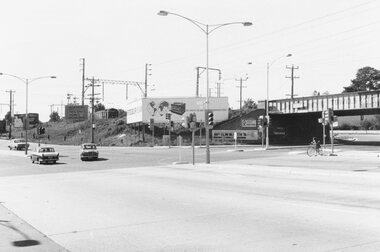
Photograph, Maroondah Highway East, Ringwood- 1969. Looking east from Warrandyte Road railway bridge
... Maroondah Highway East, Ringwood- 1969. Looking east from... photograph Maroondah Highway East, Ringwood- 1969. Looking east from ...Black and white photographWritten on back of photograph: "May 1969, Site of first clock tower." -
 Ringwood and District Historical Society
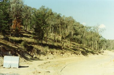
Photograph, Kubis Estate, North Ringwood in April 1978. View of the lake site looking east. The wall was where the track bends. The rope tree was on the hillside beyond the track bend
... lake site looking east. The wall was where the track bends. The.... View of the lake site looking east. The wall was where ...E548 N35 This photo was taken from almost the same spot as the 1976 one. Part of a 51-photo record of the development of the "Kubis" Estate, Ringwood North, including road works to Debbie Place, Kubis Drive, Werac Drive, Manuelo Drive, Iluka Place and Glenvale Road. From the Jack Lundy Clarke collection. -
 Ringwood and District Historical Society
Photograph, Looking east up the gully over the intersection of Werac and Kubis Drives, North Ringwood, in February 1978
... Looking east up the gully over the intersection of Werac... collection. Looking east up the gully over the intersection of Werac ...E546 N3 Part of a 51-photo record of the development of the "Kubis" Estate, Ringwood North, including road works to Debbie Place, Kubis Drive, Werac Drive, Manuelo Drive, Iluka Place and Glenvale Road. From the Jack Lundy Clarke collection. -
 Ringwood and District Historical Society
Photograph, Kubis Drive and Debbie Place, North Ringwood, on 3rd November 1978, looking east
... November 1978, looking east...., on 3rd November 1978, looking east. Photograph ...E551 N13 Part of a 51-photo record of the development of the "Kubis" Estate, Ringwood North, including road works to Debbie Place, Kubis Drive, Werac Drive, Manuelo Drive, Iluka Place and Glenvale Road. From the Jack Lundy Clarke collection.51 -
 Ringwood and District Historical Society
Photograph, Looking east from 2-6 Ringwood Street, near Maroondah Highway intersection on right, in 2008. Former Post Office was located where the small park is located (on right)
... Looking east from 2-6 Ringwood Street, near Maroondah... Haines, RDHS, in 2008. Looking east from 2-6 Ringwood Street ...Photographic record by Russ Haines, RDHS, in 2008. -
 Ringwood and District Historical Society
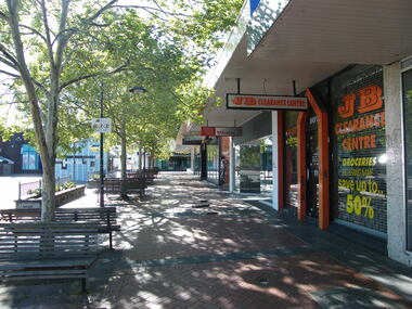
Photograph, Looking east, Civic Place, Ringwood in 2008, near the corner of Ringwood Street. Showing WestpacBank and JB Clearance Centre, with Melbourne Street at end
... Looking east, Civic Place, Ringwood in 2008, near the... Haines, RDHS, in 2008. Looking east, Civic Place, Ringwood ...Photographic record by Russ Haines, RDHS, in 2008. -
 Ringwood and District Historical Society
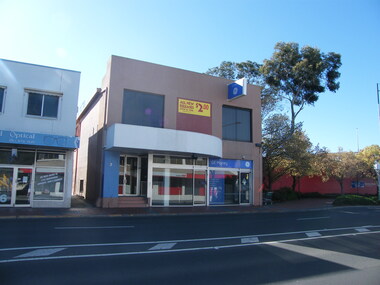
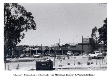
Photograph, Officeworks at the corner of Maroondah Highway and Warrandyte Road. Opening sale on 4 December 1994. Looking east over the Eastland car park
... Warrandyte Road. Opening sale on 4 December 1994. Looking east over... 1994. Looking east over the Eastland car park. Photograph ... -
 Eltham District Historical Society Inc
Photograph, Looking east along Pitt Street towards the intersection with Bible Street, Eltham, c. September 1966, 1966c
... Looking east along Pitt Street towards the intersection... photographic print Looking east along Pitt Street towards ...Black and white photographic printOriginally located in a Filmpro King Size Prints processing envelope $3.01 Shire of Eltham 9/9/66 and noted as Calrossie Ave area and crossed out Eltham-Yarra Glen Road, Bridge Street to Elsa Court existing conditions mid 1967bible street, eltham milk bar, pitt street, road construction, streets -
 Eltham District Historical Society Inc
Photograph, Looking east along Pitt Street, Eltham, c. September 1966, Stebbing Cottage on right, 1966c
... Looking east along Pitt Street, Eltham, c. September 1966... photographic print Looking east along Pitt Street, Eltham, c. September ...Stebbing cottage on rightBlack and white photographic printOriginally located in a Filmpro King Size Prints processing envelope $3.01 Shire of Eltham 9/9/66 and noted as Calrossie Ave area and crossed out Eltham-Yarra Glen Road, Bridge Street to Elsa Court existing conditions mid 1967pitt street, road construction, stebbing cottage, streets