Showing 2599 items
matching lots
-
 Kew Historical Society Inc
Plan - Subdivision Plan, Summerhill Estate, 1920-1940
Pru Sanderson, in her groundbreaking ‘City of Kew Urban Conservation Study : Volume 2 - Development History’ (1988), summarised the periods of urban development and subdivisions of land in Kew. The periods that she identified included 1845-1880, 1880-1893, 1893-1921, 1921-1933, 1933-1943, and Post-War Development. These periods were selected as they represented periods of rapid growth or decline in urban development. An obvious starting point for Sanderson’s groupings involved population growth and the associated economic cycles. These cycles also highlighted urban expansion onto land that was predominantly rural, although in other cases it represented the decline and breakup of large estates. A number of the plans in the Kew Historical Society’s collection can also be found in other collections, such as those of the State Library of Victoria and the Boroondara Library Service. A number are however unique to the collection.The Kew Historical Society collection includes almost 100 subdivision plans pertaining to suburbs of the City of Melbourne. Most of these are of Kew, Kew East or Studley Park, although a smaller number are plans of Camberwell, Deepdene, Balwyn and Hawthorn. It is believed that the majority of the plans were gifted to the Society by persons connected with the real estate firm - J. R. Mathers and McMillan, 136 Cotham Road, Kew. The Plans in the collection are rarely in pristine form, being working plans on which the agent would write notes and record lots sold and the prices of these. The subdivision plans are historically significant examples of the growth of urban Melbourne from the beginning of the 20th Century up until the 1980s. A number of the plans are double-sided and often include a photograph on the reverse. A number of the latter are by noted photographers such as J.E. Barnes.The Summerhill Estate was a subdivision in Glen Iris of 24 ‘choice allotments’. The lots were primarily on both sides of Dillon Grove. Other lots at each end of the subdivision faced Margaret Street and Summerhill Road. It was from the latter that the subdivision took its advertised title. The lots were originally advertised for £10 deposit with 20 subsequent payments over five years. Pencilled on the printed plan is a change to the deposit required; a reduction to 20/-. Annotations indicate that the new deposits ranged from 30/- to 45/-. The most expensive lots faced Summerhill Road. This subdivision plan is unusual in that the front and rear of the card are for subdivisions in different localities.subdivision plans - glen iris, summerhill estate -
 Kew Historical Society Inc
Plan - Subdivision Plan, Pointed Firs Estate, 1936
The Kew Historical Society collection includes almost 100 subdivision plans pertaining to suburbs of the City of Melbourne. Most of these are of Kew, Kew East or Studley Park, although a smaller number are plans of Camberwell, Deepdene, Balwyn and Hawthorn. It is believed that the majority of the plans were gifted to the Society by persons connected with the real estate firm - J. R. Mathers and McMillan, 136 Cotham Road, Kew. The Plans in the collection are rarely in pristine form, being working plans on which the agent would write notes and record lots sold and the prices of these. The subdivision plans are historically significant examples of the growth of urban Melbourne from the beginning of the 20th Century up until the 1980s. A number of the plans are double-sided and often include a photograph on the reverse. A number of the latter are by noted photographers such as J.E. Barnes.An almost identical plan of the ‘Pointed Firs Estate’ is in the State Library of Victoria. The plan unusually uses a photograph to show the panoramic views from the Estate. A prospective purchaser could expect to look across the Yarra Valley to Eaglemont and Heidelberg. The 36 lots advertised for sale faced Doncaster Road, Houghton Street, Maud Street and Thackray Street in Balwyn North.subdivision plans - balwyn, pointed firs estate -
 Glenelg Shire Council Cultural Collection
Photograph - Photograph - Portland Library, 10/10/1998
Coloured photo. Portland Library book sale, set up in drill hall. Lots of people looking at booksFront: '98 10 10'portland library, council services, archives -
Ringwood and District Historical Society
Legal record - Conditions of Sale (C.E.Carter), Bayswater - Crown Allotment 43. G.Kellock to J.Forrestor . Dated 7th November 1925
Particulars and Conditions of Sale of Property , Lot 20, Dorset Park Estate, Bayswater.From George Kellock to John Forrestor. -
Ringwood and District Historical Society
Legal record - Conditions of Sale (C.E.Carter), Ringwood - Electric Railway Estate, Crown Allotment 18, Purchasers B. Tilbury & A.Albon. 1925
Particulars and Conditions of Sale of Property , Lots 98 & 99 The Electric Railway Estate, to Bertie Tilbury & Arthur Albon -
Running Rabbits Military Museum operated by the Upwey Belgrave RSL Sub Branch
Firearm
Mauser. Carbine 7.62 mm, Spanish 1985 model (lots sold to IRA) SN 7897 Bolt 7897weapon, ww1, army -
 National Vietnam Veterans Museum (NVVM)
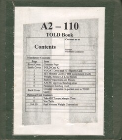
Manual, A2 - 110 TOLD Book
A green plastic foldre with white paper stuck on the front. On the white paper there is lots of information in a table format in black in.passenger safety briefing, aircraft -
 Bendigo Historical Society Inc.
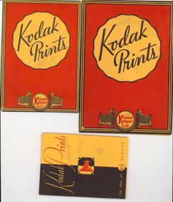
Photograph - BILL ASHMAN COLLECTION: BULK LOT OF PHOTO NEGATIVES
Bulk lot of photographic negatives in Kodak folders, subjects include unknown people, Bendigo, most relating to Scalebuoys.photograph -
 Bendigo Historical Society Inc.
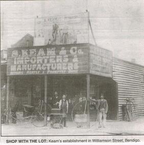
Newspaper - JENNY FOLEY COLLECTION: SHOP WITH THE LOT
Bendigo Advertiser "The way we were" from 1999. Shop with the lot: Keam's establishment in Williamson Street, Bendigo.newspaper, bendigo advertiser, the way we were -
Whitehorse Historical Society Inc.
Letter - Correspondence, Rate collection, 01/08/09/1933
Correspondence between Shire of Blackburn and Mitcham and the State savings Bank of Victoria re houses and lots 40 and 41.Correspondence between Shire of Blackburn and Mitcham and the State savings Bank of Victoria re houses and lots 40 and 41.Correspondence between Shire of Blackburn and Mitcham and the State savings Bank of Victoria re houses and lots 40 and 41.holt, john j., state savings bank of victoria, deakin street, mitcham lots 40 / 41, rates, shire of blackburn and mitcham -
 Kew Historical Society Inc
Plan - Subdivision Plan, Glenferrie Road & Wellington St, Kew, c.1920s
Subdivision plans are historically important documents used as evidence of the growth of suburbs in Australia. They frequently provide information about when the land was sold on which a built structure was subsequently constructed as well as evidence relating to surveyors and real estate and financial agents. The numerous subdivision plans in the Kew Historical Society's collection represent working documents, ranging from the initial sketches made in planning a subdivision to printed plans on which auctioneers or agents listed the prices for which individual lots were sold. In a number of cases, the reverse of a subdivision plan in the collection includes a photograph of a house that was also for sale by the agent. These photographs provide significant heritage information relating house design and decoration, fencing and household gardens.An unnamed subdivision in Kew including eleven lots for sale bordering Glenferrie Road, Wellington Street and Franks Grove.subdivision plans - kew, franks grove, wellington street, glenferrie road -
 Bendigo Historical Society Inc.
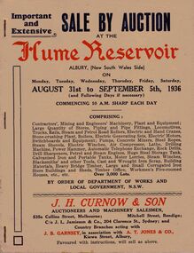
Document - IAN DYETT COLLECTION: AUCTION CATALOGUE - HUME RESERVOIR
Pale beige auction catalogue with red and dark blue printing for a sale held from the 31st August to 5th September 1936 at the Hume Reservoir, Albury, (New South Wales Side) By Order of Department of Works and Local Government, N. S. W. For sale was Contractors', Mining and Engineers' Machinery, Plant and Equipment, Stores, Locomotives, Tools, Petrol and Steam Engines, Tanks, Scrap, Building Materials, Heavy Bridge Timber, Buildings, and Workmen's Five-roomed Houses, etc. J. H. Curnow & Son were the auctioneers. Black and white photos include Lots 2065 and 2622 Kelly & Lewis Engine and Condensing Plant with G.E.C. Dynamo, Generating 300 K.W.; Lot 2018 Locomotive; Lots 2617 and 2618 Steam Road Rollers; Lot 2069 Administrative Offices; and Lot 93 Locomotives (Victorian Side).business, auctioneers, j h curnow & son pty ltd, ian dyett collection - auction catalogue - hume reservoir, department of works and local government nsw, j h curnow & son, j l jamieson & co, j b garnsey, a t jones, bolton bros pty ltd -
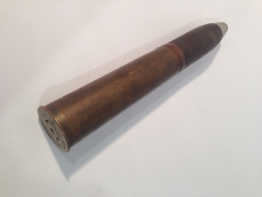
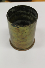 Dandenong/Cranbourne RSL Sub Branch
Shell Casing, 1945
Shortened 105 mm artillery shell. brass material.105 mm M14.Lot ESS 1 - 111-1945. -
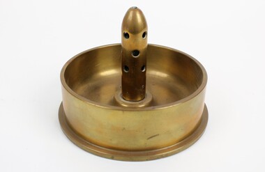 Ringwood RSL Sub-Branch
Souvenir Trench Art, Circa WW2
Cut down brass shell case of a 4.5 inch shell. Inert fuse still in place. Height 5.5 Width 17cm Mo 3. No 17 Mk2 ANMF. Lot 10 MF -
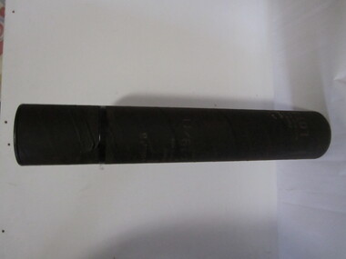 Ballarat RSL Sub-Branch Inc.
Container - 81mm Mortar
Numerous markings on side, LOT JA-1-19/11second world war (ww2), 1939 - 1945, weapons, ballarat rsl, ballarat -
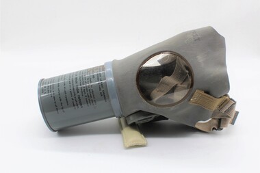 Ballarat RSL Sub-Branch Inc.
Gas mask US, 1941-1945
Used during ww2 for civilans Historic item used in ww2 Light grey, gas mask came with instrucions instructions on canister, med adult ,USRL, PRC,lot 642 -
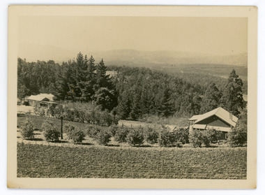 Mt Dandenong & District Historical Society Inc.
Photograph, Walker's LOT 2
Harry Walker's property would have been run by his son William in 1922. When the CRB Road cut through the property William planted plum trees on the opposite side. These are visible in this photo. An extensive raspberry crop is in the foreground. The building over the road on the left hand side is the corn and produce store built by Edward John Price (son of Edward Joseph Price) to capitalise on the CRB Road cutting through the Price farm. John Lundy-Clarke grew up in the Kalorama/Mt Dandenong area and later in life (1972-74) began to write a comprehensive history of the area working from an original settlement map in an effort to cover all areas.Small black and white postcard showing a crop in foreground with a house to the right. A road passes through the centre with a house on the left on the opposite side of the road. A view to the ranges in the distance. A handwritten description on reverse by John Lundy-Clarke.View at Kalorama. View over LOT 2 (Walkers) 1922.harry walker, william walker, crb road, raspberry, edward john price, edward joseph price, produce store, store -
 Montmorency/Eltham RSL Sub Branch
Weapon - British QF 2 Pounder 40mm Naval (Pom-Pom) Round, Brass Shell Case, 1931 (shell case), 1941 (projectile)
The Ordnance QF (Quick-firing) 2-pounder was a 40mm British autocannon known as the 'pom-pom' and used as an anti-aircraft gun by the Royal Navy. The name came from the sound that the original guns made when firing. This QF 2-pounder is not the same 2 pounder used by the British Army as an anti-tank gun and a tank gun, although they both fired 2 pounds (40mm) projectiles. Brass shell case with iron/steel explosive projectile2 PR 1 1931 CF MF LOT 15anti-tank -
 Ringwood and District Historical Society
Photograph, Lot 66 (No.5) Howard Ave, Ringwood East, taken from backyard of Lot 67 (No.3) - 1/9/1974
Written on back of photograph, "Lot 66 (No.5) Howard Ave. Taken from in backyard of Lot 67 (No.3) (8' off ground). 1/9/1974". -
 Kew Historical Society Inc
Plan - Subdivision Plan, Maxwelton, Kew, 1920-1940
Pru Sanderson, in her groundbreaking ‘City of Kew Urban Conservation Study : Volume 2 - Development History’ (1988), summarised the periods of urban development and subdivisions of land in Kew. The periods that she identified included 1845-1880, 1880-1893, 1893-1921, 1921-1933, 1933-1943, and Post-War Development. These periods were selected as they represented periods of rapid growth or decline in urban development. An obvious starting point for Sanderson’s groupings involved population growth and the associated economic cycles. These cycles also highlighted urban expansion onto land that was predominantly rural, although in other cases it represented the decline and breakup of large estates. A number of the plans in the Kew Historical Society’s collection can also be found in other collections, such as those of the State Library of Victoria and the Boroondara Library Service. A number are however unique to the collection.The Kew Historical Society collection includes almost 100 subdivision plans pertaining to suburbs of the City of Melbourne. Most of these are of Kew, Kew East or Studley Park, although a smaller number are plans of Camberwell, Deepdene, Balwyn and Hawthorn. It is believed that the majority of the plans were gifted to the Society by persons connected with the real estate firm - J. R. Mathers and McMillan, 136 Cotham Road, Kew. The Plans in the collection are rarely in pristine form, being working plans on which the agent would write notes and record lots sold and the prices of these. The subdivision plans are historically significant examples of the growth of urban Melbourne from the beginning of the 20th Century up until the 1980s. A number of the plans are double-sided and often include a photograph on the reverse. A number of the latter are by noted photographers such as J.E. Barnes.The subdivision, ‘Maxwelton’, included four lots in East Kew, at the northwest corner of Burke Road and Cotham Road. Lot 3 is identified as the location of an existing house. The site of the subdivision equates to that parcel of land where a contemporary block of three storey apartments at 1245 Burke Road is now located.subdivision plans - kew, mazwelton subdivision, burke road -- kew (vic.), cotham road -- kew (vic.) -
Ringwood and District Historical Society
Legal record - Conditions of Sale (C.E.Carter), Ringwood - Crown Allotment 27 . H.J.Marshall to F.Powell. Dated 23 February 1924
Particulars and Conditions of Sale of Property , Munro Street, Ringwood. Lot 112 Ringwood Park Estate. From H.J.Marshall to F.Powell. -
Ringwood and District Historical Society
Legal record - Conditions of Sale (C.E.Carter), Mitcham - Crown Allotment 124. M.E.Burke to ? Dated June 1st 1929
Particulars and Conditions of Sale of Property , Lot 44 and 45 on Plan of Subdivision 6736, Mitcham Road, Mitcham. Mrs M.E.Burke to ? -
Ringwood and District Historical Society
Legal record - Conditions of Sale (C.E.Carter), Nunawading - Crown Allotment 77. H.Jackman to L.Cook, Dated 29th June 1925
Particulars and Conditions of Sale of Property , Lots 8 and 9, Peacedale Estate, Nunawading. From Harry Jackman to Laurence Cook. -
Ringwood and District Historical Society
Legal record - Conditions of Sale (C.E.Carter), Blackburn - Crown Allotment 77 , D.Casamento to Miss J.A.E. Stallard -1927
Particulars and Conditions of Sale of Property , Lots 13 & 14, Peacedale Estate, Nunawading. From Domenico Casamento to Jessie Stallard. -
Glenelg Shire Council Cultural Collection
Photograph - Photograph - Spray Wall Construction, n.d
Port of Portland Authority Archivesport of portland archives, portland harbour -
Glenelg Shire Council Cultural Collection
Photograph - Photograph - Quarry, Blacknose, 03/12/1952
Port of Portland Authority ArchivesFront: Front- Blacknose Quarry face 3/12/52 before second blast'- Printed bottom frame. Back- Purple PHT Stamp '5/7'- top left, black inkport of portland -
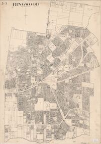 Ringwood and District Historical Society
Map, City of Ringwood - Rateable Properties Layout - c.1966
A0-size (approx) map of named streets, lot-numbered properties and locality features within City of Ringwood boundary. Scale: 8 chains to 1 inch. City Engineer's signature in bottom right corner - Alan Robertson (City Engineer 1958-1987) -
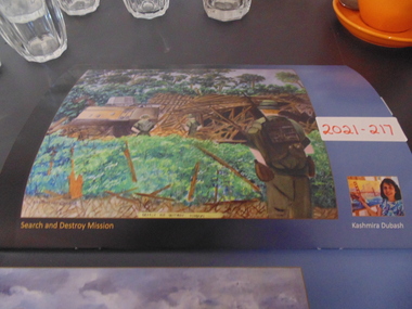 National Vietnam Veterans Museum (NVVM)
Painting, Search And Destroy Mission
an original painting of two soldiers and a tank in front of a building that has been destroyed. Lots of grass and trees also in the paintingpainting, vietnam lest we forget, soldiers -
Whitehorse Historical Society Inc.
Legal record - Land Title, Certificate of Title, 29/08/1922 12:00:00 AM
Certificate of Title, mortgage details and rate notices for Lot 24 Myrtle Grove, Blackburn owned by Alfred samuel Wright.Certificate of Title, mortgage details and rate notices for Lot 24 Myrtle Grove, Blackburn owned by Alfred samuel Wright.Certificate of Title, mortgage details and rate notices for Lot 24 Myrtle Grove, Blackburn owned by Alfred samuel Wright.wright, alfred samuel, certificates, myrtle grove, blackburn, lot 24, laburnum street, blackburn -
Whitehorse Historical Society Inc.
Legal record - Document, Certificate of Title, 28/10/1913 12:00:00 AM
Certificate of Title for Lot 41, Plan of Subdivision no. 2525, Deakin Street Mitcham, owned by State Savings Bank of Victoria.Certificate of Title for Lot 41, Plan of Subdivision no. 2525, Deakin Street Mitcham, owned by State Savings Bank of Victoria.Certificate of Title for Lot 41, Plan of Subdivision no. 2525, Deakin Street Mitcham, owned by State Savings Bank of Victoria.deakin street mitcham, state savings bank of victoria