Showing 518 items
matching map of mine
-
 Bendigo Historical Society Inc.
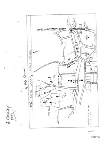
Document - LONG GULLY HISTORY GROUP COLLECTION: THE LONG GULLY GOLF LINKS
Some history of the Long Gully Golf Links, a 9 Hole Course, by John Harvey. First page has a map of the area showing where the holes are and different features. There is a description of the tees and the route taken around the course.Dates when the Eaglehawk, Neangar park, Kangaroo Flat Golf Clubs and the Long Gully Playground were opened.bendigo, history, long gully history group, the long gully history group - the long gully golf links, a crossley, john harvey, long gully rec, dai gum san reservation, quarry hill golf club, bendigo golf club, marong gulf club, miss colgan, sacred heart cathedral choir, mechanics institute, rose of australia hotel, north hercules and energetic mine site, les thomas, tom austen, pearl south mullock heap, doc catford, clubs wearne, pearl mining co's diggings, pearl south, pearl east, bill and faye osterfield, ellen lee osterfield, eaglehawk gold club, neangar park golf club, f m fitzpatrick, kangaroo flat golf club, long gully playground, pearl sands, ennor brothers, birchmore brothers, shirley harvey, belvoir park, harold ennor, george ennor -
 Bendigo Historical Society Inc.
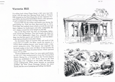
Document - LONG GULLY HISTORY GROUP COLLECTION: VICTORIA HILL
Three pages numbered 18/19, 20/21 and 22/23 titled Victoria Hill. First page has some information on Victoria Hill, a sketch of W Rae's Home and Rae's Open cut. The second page has a map of the Victoria Hill Area showing streets and the New Chum Anticline, a sketch of Ballerstedt's Open Cut and a Key to Victoria Hill Area Map. The third page mentions the Victoria Quartz mine, Tributors and quartz roasting. It also has sketch of a 20 Head Crushing Battery, Victoria Hill.bendigo, history, long gully history group, the long gully history group - victoria hill, gold mines hotel, christopher ballerstedt, theodore ballerstedt, ballerstedt's open cut, lansell's 180 mine, little 180 mine, new chum syncline battery, victoria reef quartz mining co, victoria quartz, new chum drainage scheme, a roberts and sons, tributors, william rae's bon accord mine and open cut, william rae, adventure and advance open cuts, central nell gwynne, heinz butcher shop -
 Bendigo Historical Society Inc.
Book - MINING & GEOLOGICAL JOURNAL VOL.2, NO.3, 1940
Mining & Geological Journal Vol.2. No.3. September 1940. Published by the Department of Mines Victoria with articles on mining, photographs, maps & advertisements. Name on front A.Richardson 29 Harrison St Bendigo. Softcover.Department of Mines Victoriamagazine, organization, mining, mining, mines, mining equipment. -
 Bendigo Historical Society Inc.
Book - MINING & GEOLOGICAL JOURNAL. VOL,4. NO,4, 1951
Mining and Geological Journal, Volume 4, No.4. September 1951. Published by Department of Mines Victoria with 65 pages of articles on gold, coal & oil mining, Illustrations, maps, photographs including photographs of Bendigo mines. Name noted on front A.E.Richardson 29 Harrison St Bendigo.Dept of Mines Victoriamagazine, organization, mining, mining - mines - mining equipment, bendigo mines. -
 Bendigo Historical Society Inc.
Book - MINING & GEOLOGICAL JOURNAL. VOL,4. NO.3, 1951
... . Published by Department of Mines Victoria with articles on Mines... MINES mining Mining - Mines - Mining Equipment Central Deborah ...Mining and Geological Journal, Vol.4, No.3. March 1951. Published by Department of Mines Victoria with articles on Mines & mining including Bendigo mines with Photographs, Illustrations, Maps & Advertisements. Name on front A.Richardson 29 Harrison St Bendigo.Dept of Mines Victoria.gold mines, mining, mining - mines - mining equipment, central deborah mine. -
 Bendigo Historical Society Inc.
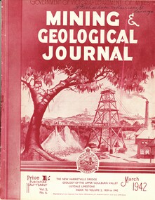
Book - MINING & GEOLOGICAL JOURNAL. VOL.S,NO.6, 1942
... and mining including Bendigo mines, Photographs, Illustrations, Maps... MINES mining Mining - Mines - Mining Equipment. Bendigo mines ...Mining & Geological Journal, Vol.2, No.6. March 1942. Published by Department of Mines Victoria, with articles on mines and mining including Bendigo mines, Photographs, Illustrations, Maps & Advertisements. Name on cover A Richardson 29 Harrison St Bendigo.Dept of Mines Victoriagold mines, mining, mining - mines - mining equipment. bendigo mines. -
 Bendigo Historical Society Inc.
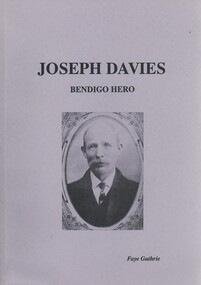
Book - JOSEPH DAVIES BENDIGO HERO, c1990
Joseph Davies Bendigo Hero. Publisher: Aristoc Press Pty Ltd, Glen Waverly. ISBN:0 9589415 1 3. Edition: Second. 155 pages. Photographs, illustrations, maps & copies of letters. Poems about Joseph Davies. Signed: Donated by Faye Guthrie 17/2/91. Meeting in Town Hall addressed by Sir John Quick and Mr McBride. Resolution within testimonial. The Advertiser Fund. The Mayor's Fund. Stock Exchange Fund.Faye Guthrieautobiography, davies, joseph, copyright, janet f guthrie 1988. joseph davies miner family register, rescue john allan bendigo consolidated mine diamond hill medal -
 Bendigo Historical Society Inc.
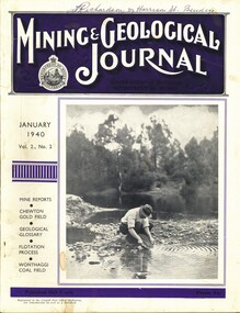
Book - MINING & GEOLOGICAL JOURNAL VOL.2, NO2, 1940
... , articles on mines, photographs, illustrations, maps... MINES mining Mining - Mines - Mining Equipment Axedale ...Mining & Geological Journal, January 1940, Vol.2, No.2. Published by Department of Mines Victoria, 136 pages of Mine Reports, articles on mines, photographs, illustrations, maps & advertisements. Name on cover A.Richardson 29 Harrison St Bendigo.Dept of Mines Victoriagold mines, mining, mining - mines - mining equipment, axedale - fletchers mine. -
 Bendigo Historical Society Inc.
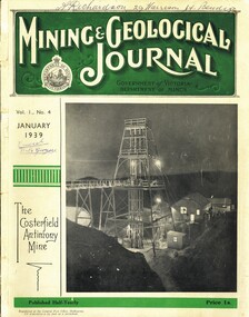
Book - MINING & GEOLOGICAL JOURNAL. VOL 1, NO.4, 1939
Mining & Gelogical Journal Vol.1, No.4. January 1939 published by the Department of Mines Government of Victoria, 72 pages with photographs, illustrations, maps & advertisements. Articles on mining including some Bendigo & district mines.Name on cover A.Richardson 29 Harrison St Bendigo.Department of Mines Victoria.magazine, organization, mining, mining - mines - mining equipment, bendigo mines.central nell gwynne. -
 Bendigo Historical Society Inc.
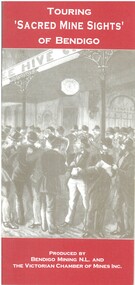
Book - TOURING 'SACRED MINE SIGHTS' OF BENDIGO, c1994
... . Maps. Book TOURING 'SACRED MINE SIGHTS' OF BENDIGO ...Touring 'Sacred Mine Sights' of Bendigo. Gold was discovered in 1851 and the mining era continued until 1954. Produced by Bendigo Mining NL and The Victorian Chamber of Mines Inc. Place of publication: Bendigo. 16 pages. Maps.David G Horsfallbendigo, mining, mining history guide for toursts, history bendigo mines locations -
 Bendigo Historical Society Inc.
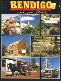
Book - BENDIGO, THE GOLDEN HEART OF VICTORIA
Bendigo The Golden Heart Of Victoria 22 pages with colour photos and maps.Rosalie Trower, Annette Boylebendigo, tourism, bendigo, sacred heart cathedral, sandhurst town, central deborah gold mine, talking tram. -
 Bendigo Historical Society Inc.
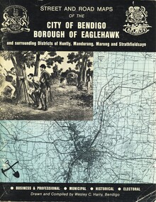
Book - STREET AND ROAD MAPS OF THE CITY OF BENDIGO BOROUGH OF EAGLEHAWK, c1980
Street and Road Maps of the City of Bendigo Borough of Eaglehawk and surrounding Districts of Huntly, Mandurang, Marong and Strathfieldsaye, in color. Drawn and compiled by Wesley C Harry, Bendigo. Publisher: Cambridge Press, Bendigo. ISBN: 9598608.2.2. 68 pages. Photographs, Illustrations & maps. Photos include: Bendigo buildings, scenery mines, streetscapes, parades, pioneer leaders of Bendigo. Many advertisements throughout. List of Justices of the Peace, hospitals, homes for the aged, schools, churches. Page 58: Copy of ''Freedom of the City to the Australian Survey Regiment'' proclamation, 14th June 1970. Maps cover an area of some 169 sq. miles (43,772 hectares). Origin of the name Bendigo. Information on the five Wards of Bendigo, and their councilors.Wesley C Harrybook, bendigo, bendigo & district maps, bendigo and districts map, buildings, streetscapes, historical pictures, advertisements, historical information, commisioners camp, sandhurst -
 Bendigo Historical Society Inc.
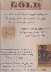
Document - 'GOLD' POSTER WITH DESCRIPTION OF NUGGETS
Poster heading - 'Gold' - 'In the whole world, only 47 nuggets weighing over 30lbs Troy have been recorded. Of these 40 are from Australia. The region from Ballarat around to Bendigo yielded 32 of these large nuggets. This monument erected in 1897 by the Mines Department, is the only one ever erected to honour the discovery of a gold nugget. The 'Welcome Stranger' nugget was unearthed on 5th February, 1869, weighing 2316 ounces and it was sold for 9.553 pounds'. Poster includes a map of Victoria depicting the main gold mining areas, also mention of gypsum, and tin in northern Victoria. A photo of the monument to the discovery of the 'Welcome Stranger' nugget found 1 1/4 miles from Moliagul in the bottom corner.document, gold -
 Bendigo Historical Society Inc.
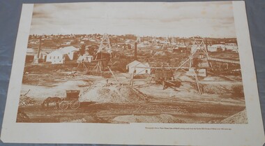
Photograph - Photograph of New Chum Line of Reef
BHS CollectionSepia coloured print of a photograph of the New Chum Line of Reef looking south from the Snobs Hill group of mines. The photo shows several poppet heads and chimneys, bridges and houses. New Chum Line of Reef. includes Victoria Hill possibly the richest spot on the field.On the back a drawing of a poppet head with the words: Bendigo gold project. A small map of Victoria is also printed on the back. bendigo mines, new chum line of reef, mining -
 Bendigo Historical Society Inc.
Map - BENDIGO HISTORICAL SOCIETY COLLECTION: EAGLEHAWK MINE MAP
... BENDIGO HISTORICAL SOCIETY COLLECTION: EAGLEHAWK MINE MAP... BENDIGO Mining eaglehawk mines Base map Australian map grid ...Base map Australian map grid of Eaglehawk area. Map has letter attached from the Department of Conservation, Forests and Lands, 22 March, 1990, addressed to Felicity Kingerlie, BHS, requesting information regarding the historic mining sites marked on the map. Sites marked are: A. Golden Age Mine, engine mountings present B. Johnson's No. 2 Mine, engine mountings, old boiler foundations C. Johnson's No. 1 Mine, mullock retaining wall made from sandstone, engine mountings, remains of old building demolished? D. Toma's Eucalyptus Factory, old boiler still there, boiler shed, chimney (remnants of) outlet drain, distilling vats, dam, remnant of winch. E. New Argus Mine,mullock heap F. New Moon Mines Dams (1) stone walls G. North Lightning Hill Mine, engine mountings, quartz retainer wall, Pascoe and Simmons open cuts and other open cuts here too H. New Prince of Wales Mine and Poppet Head I. Quarry site for stone, excavation (for miners cottages in Clarke Street) J. Lancashire open cut mine K. Virginia Hill (cynaide vats etc) L. South Prince of Wales mine, now capped and fenced M (possibly ) Catherine United Mine, engine mountings, battery mountings?bendigo, mining, eaglehawk mines -
 Bendigo Historical Society Inc.
Document - DEBORAH REEF PROJECT ENVIRONMENT EFFECTS STATEMENT
Two page document. On top, first page ' Bendigo Mining N.L., Deborah Reef Project, Environment Effects Statement, Summary Brochure'. Poppet head on top LH corner of document. A map of central Bendigo is drawn on page 1 and shows the location of the proposed processing plant near the Airport. Further maps on page 2 and 3 show the North Deborah Mine Site, the pipeline route and the airfield site. The summary brochure provides an outline of the material contained in the Environment Effects Statement and proposed planning scheme amendments upon which, the Deborah Reef Project will be assessed. Page four lists the issues that impact on this submission: planning and land use; socio economic environment; traffic; discharges to air; water management; explosives storage and handling; subsidence; heritage; flora and fauna and landscape and visual assessment. The 16th March, 1989, is the date given for submissions to be lodged in regard to this project.Bendigo Mining N.Lbendigo, mining, deborah reef project -
 Bendigo Historical Society Inc.
Map - GEOLOGICAL MAP BENDIGO GOLD FIELD
Geological map Bendigo gold field. Showing anticlines, synclines, shafts, alluvial, contours. Produced by the deprtment of mines. Two originals plus two laminated copies -
 Bendigo Historical Society Inc.
Document - ALBERT RICHARDSON COLLECTION: SECRETARY FOR MINES ANNUAL REPORT 1911
Three page typed report titled ' Notes on diagram showing pitch lines, Bendigo'. Longitudinal sections along the lines of reefs or anticlines within the 8 mile block at Bendigo are shown in a diagram' (diagram not included with notes) Mines and reef lines mentioned in the report are : New Chum line, New Chum Railway mine, Catherine United mine, Hercules and Energetic mine, Garden Gully, Hustlers and Redan, Sheepshead Reef, Sea Mine, Garden Gully, Miller's line of reef and Bendigo Development Mine. The 'old stacks' or chimneys, on Bendigo are described. 'Among the earliest of the stacks built at Bendigo in connexion with Quartz crushing plant, are the two figured in this Annual report No 1 was situate in Sailor's Gully but was demolished about three years ago. This, if not the first, must have been one of the first built, for it had a stone inserted on which chiselled the date 1854. It was built altogether of rough masonry. The other, No. 2, is still standing at the Sheepshead line and was apparently of later date, the upper portion being of brick. They are intersting landmarks of an era that is rapidly passing.' Map attached to report showing location of stacks. Stack at Sailors Gully was near the corner of Murchison Street and Lester Street. The stack at Sheepshead ( Deborah Triangle area) was near the intersection of Belle Vue Road and Adam Street.bendigo, mining, pitch lines bendigo -
Bendigo Historical Society Inc.
Book - TOURING SACRED MINE SIGHTS OF BENDIGO, 1994
... of old mine sites. Includes 3 maps.... tours of old mine sites. Includes 3 maps. Book TOURING SACRED ...16 page booklet 'Touring Sacred Mine Sights of Bendigo' Produced by Bendigo Mining and the Victorian Chamber of Mines.1994. Researched and written by David Horsfall and printed by Bendigo Modern Press. Details and suggested walking and driving tours of old mine sites. Includes 3 maps.David G Horsfall -
Bendigo Historical Society Inc.
Document - STRUCTURE OF BENDIGO GOLDFIELD BULLETIN NO. 47
Booklet, 36 pages, that describes the structure of the Bendigo Goldfield. Booklet is enclosed in an envelope. On front of booklet : 1923 Victoria, Department of Mines, Bulletins of the Geological Survey of Victoria, W. Baragwanath, Director. Structure of Bendigo Goldfield, by H. Herman, late Director of Geological Survey. Maps under catalogue number 3769 accompanied the booklet and are listed as 'plates' on the contents page. Plans and Sections to accompany Bulletin No 47, Structure of Bendigo Gold-Field, by H Herman, B.C.E., M.M.E., F.G.S., late Director of Geological Survey.Geological Survey of Victoriabendigo, gold mining, structure of goldfield, bendigo, goldfield, gold mining, geology -
Bendigo Historical Society Inc.
Map - MINE LOCATION DRAWING AT VICTORIA HILL
... in pencil. Map MINE LOCATION DRAWING AT VICTORIA HILL ...Claims and shafts location for: Rae and co. - Noye and co. - Wittscheibe. Some additions to drawing made in pencil.mining, business -
 Bendigo Historical Society Inc.
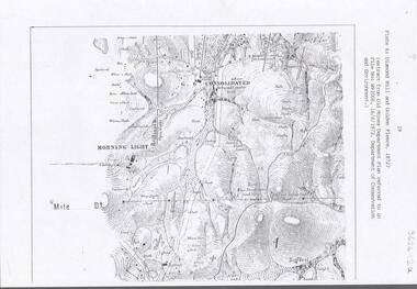
Document - DIAMOND HILL AREA MAP
Map copy, 2 pages, from 'Old Mines Department Plan, Dept of Conservation and Environment File No W91006, 16.6.1972' Map shows Golden Gully area with 'Town and Country Hotel' on north side and further south, with shafts and mine names marked.bendigo, mining, diamond hill -
 Bendigo Historical Society Inc.
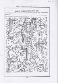
Document - DIAMOND HILL, GOLDEN GULLY COSERVATION AREA
Map of Golden Gully conservation area comprising Glasgow and Golconda Consolidated, Glasgow Reef Company (Golden Gully) and New Napoleon. The area is significant because it contains the 'best evidence for hydraulic sluicing on the field as well as several early reef mining sites' On top of page 'Eaglehawk & Bendigo Heritage Study, Significant areas' Mines marked on page: Goldfields Extended shaft South Concord shaft Concord shaft Morning Light shaft Hansel and Mundy shaftbendigo, mining, golden gully -
 Bendigo Historical Society Inc.
Document - STAFFORD REEF MINE SITE, DIAMOND HILL
One page document describing the Stafford Reef Mine Site, Diamond Hill, Site 4.11, prepared by David Bannear. Information includes the map/grid references of the site and an overview of the history of the Stafford Reef Mine. The physical remains of the mine are described..bendigo, mining, stafford reef mine -
Bendigo Historical Society Inc.
Map - HUSTLER'S & CHRISTMAS LINES OF REEFS - PLAN OF LINES OF SECTION OF REEFS
Underground Survey of Mines Bendigo. Plan of Cross Section Lines Shewing Connections with Trigonometrical Stations and Base Lines. 13/3/99 Signed ? Stirling. Places and mines mentioned Speciman Hill, Tambour Major, Lansell's 180, Victory and Pandora, Great Extended Hustler's, Windmill Hill on Victoria Reef. Next part of map is a Plan of Lines of Section between the Hustler's and Christmas Lines of Reefs. 8/3/99. Signed ?. Transverse Section. Shows Tambour Major Co., near the Christmas Line of Reef, Crosscuts and their depth, geological features and stone encountered. Then shows Thistle Line, Charshalton Line, Napoleon Line, Nell Gwynne Line, New Chum Line, Lansell's No 180 with levels, depths and geological features. Drawing is continued in three parts to fit on paper. Lansell's East Shaft with levels and depths, geological features and stone encountered. Sheepshead Line, Old Shaft, Garden Gully Line, Victory and Pabndora Co with crosscuts, depths, geological features and stone encountered. Paddy's Gully Line, Derby Line, Millers Line, Hustler's Line, Great Extended Hustler's Co with levels, depths, geological features and stone encountered. A note beside a Saddle Reef: 360,000 pounds paid in dividends from this reef. Average ounces per ton gold noted where found. Reference Table for stone and geological features. Datum Line 700 feet above Sea Level Unscannedmining, parish map, hustler's & christmas lines of reefs, plan of lines of section of reefs, ? stirling, specimen hill, tambour major, lansell's 180, victory & pandora, great extended hustler's, windmill hill, victoria reef, tambour major co, christmas line, hustler's line, thistle line, carshalton line, napoleon line, nell gwynne line, new chum line, lansell's no 180, lansell's east shaft, sheepshead line, old shaft, garden gully line, paddy's gully line, derby line, miller's line, hustler's line, great extended hustler's co -
 Bendigo Historical Society Inc.
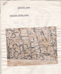
Document - CARLISLE UNITED MINE - LOCALITY PLAN
2 typed foolscap copies of notes on the Carlisle United mine on the Garden Gully Line of Reef. One has 10.5 x 14 cm map attached to the front. Notes are the same as 3501.1 notes.mine, gold, carlisle united, carlisle united mine, carlisle united mine locality plan. -
 Bendigo Historical Society Inc.
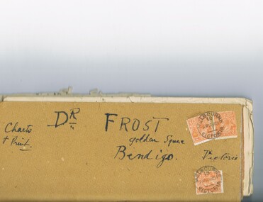
Document - MCCOLL, RANKIN AND STANISTREET COLLECTION: DR FROST, 1920
Correspondence to Dr. Frost re Badak Tin Mine. Binti Binti, Sweet Nell, Bettina, Mascotte & Maconi. Report on inspection of mine reports by Mr. M. Sheard (Mine Manager) & Dr. C. W. Laver of Kalgoorlie, map of Binti lease. Des Frost Golden Square Bendigo Victoria, charts and print.MCCOLL RANKIN & STANISTREETorganization, business, gold mining, mccoll rankin & stanistreet -
 Bendigo Historical Society Inc.
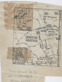
Negative - TOM PATULLO COLLECTION: SEBASTIAN GOLDFIELD
Negative,/Hand drawn of the goldfield featuring gold mine sites,cyanide vats,heaps,railway station,sports ground. A small map of the Whipstick area, and legend. Tom Patullo was formerly of Clear-Ads Bendigo.cottage, miners, sebastian goldfield, sebastian goldfield -
 Bendigo Historical Society Inc.
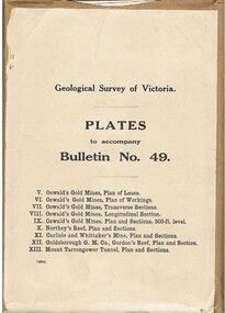
Book - MCCOLL, RANKIN AND STANISTREET COLLECTION: PLATES TO ACCOMPANY BULLETIN NO.49 MALDON GEOLOGICAL SURVEY OF VICTORIA
Book; Brown paper containers with plates (& maps) to accompany bulletin No49 of geological survey of Victoria. V Oswalds G.M. Plan of lease. VI. Oswalds G. M. Plan of workings. VII. Oswalds G. M. Transverse Sect. VIII. Oswalds G. M. Longit. Section. IX. Oswalds G. M. Plan & Sect. 500ft. Level. X. Northey's Reef plan & sections. XI. Carlisle and Whittaker's Mine Plan & Sections.XII. Goldsborough G. M. Co. Gordon's Reef, Plan & Section. XIII. Mount Tarrengower Tunnel Plan & Section.MCCOLL RANKIN & STANISTREETorganisation, industry, surveys, mccoll rankin & stanistreet -
 Bendigo Historical Society Inc.
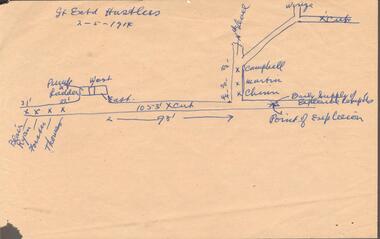
Document - GREAT EXTENDED HUSTLERS MINE - MAP WHERE EXPLOSION OCCURRED
... GREAT EXTENDED HUSTLERS MINE - MAP WHERE EXPLOSION OCCURRED... Gold great extended hustlers. Great Extended Hustlers Mine Map ...Hand drawn map on beige paper where an explosion occurred in the mine killing seven men. They were Blair, Ryan, Forster, Thomas, Campbell, Martin and Chinn. Map shows where the men were, how far from the point of explosion.mine, gold, great extended hustlers., great extended hustlers mine, map where explosion occurred, blair, ryan, forster, thomas, campbell, martin, chinn