Showing 378 items matching "north court"
-
 Ringwood and District Historical Society
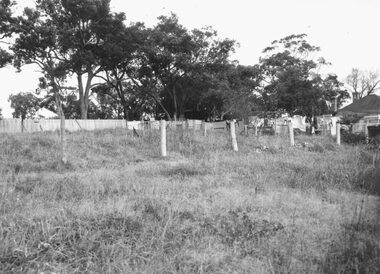
Photograph, Land and Post Fence - to be identified. Ringwood 1963 (Eastland Litigation Photo)
This series of SS0380 photos are part of the "Eastland Litigation" launched in 1962 by the Whitehorse Traders Co-operative Association (WTCA), against the Ringwood Council's Interim Development Order of 1960. WTCA sought "orders from the Supreme Court of Victoria that the planning scheme was invalid" - See "The Eastland Litigation" chapter in "From Horse Shoes to High Heels - Ringwood Shopping Centre and Eastland 1858-2008" by Richard Carter, Bounce Books 2009.Black and White PhotgraphStamped on back of picture, 'Edwin G. Adamson...'. And Stamped "In the Supreme Court, 13 Aug 1963 E.W.L." -
 Ringwood and District Historical Society
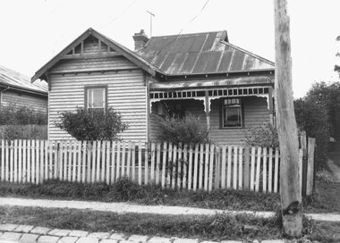
Photograph, Edwin G. Adamson A.R.P.S, House Adelaide St., Ringwood 1963 (Eastland Litigation Photo)
This series of SS0380 photos are part of the "Eastland Litigation" launched in 1962 by the Whitehorse Traders Co-operative Association (WTCA), against the Ringwood Council's Interim Development Order of 1960. WTCA sought "orders from the Supreme Court of Victoria that the planning scheme was invalid" - See "The Eastland Litigation" chapter in "From Horse Shoes to High Heels - Ringwood Shopping Centre and Eastland 1858-2008" by Richard Carter, Bounce Books 2009.Black and White PhotographWritten on back of photograph, 'House Adelaide St.' Stamped on photograph, 'Edwin G. Adamson'. Part of the Eastland Litigation series. One copy stamped "In the Supreme Court 13 Aug 1963" -
 Ringwood and District Historical Society
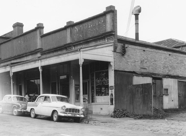
Photograph, Edwin G. Adamson A.R.P.S, Building fronting Adelaide St. Ringwood, buildings being portion of those known as 'The Block' 1963 (Eastland Litigation Photo)
This series of SS0380 photos are part of the "Eastland Litigation" launched in 1962 by the Whitehorse Traders Co-operative Association (WTCA), against the Ringwood Council's Interim Development Order of 1960. WTCA sought "orders from the Supreme Court of Victoria that the planning scheme was invalid" - See "The Eastland Litigation" chapter in "From Horse Shoes to High Heels - Ringwood Shopping Centre and Eastland 1858-2008" by Richard Carter, Bounce Books 2009.Written on back of photograph, 'Photo of the building fronting Adelaide St., buildings being portion of those known as 'The Block'. Photo showing shops on the west side of Adelaide St., near its junction with Maroondah Highway.. Fish and Chip shop" Stamped on photograph, 'In the Supreme Court 13 Aug. 1983' and 'Edwin G. Adamson...May 62'. -
 Ringwood and District Historical Society
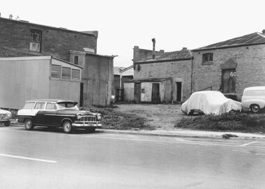
Photograph, Edwin G. Adamson A.R.P.S, Rear of buildings knows as 'The Block', Ringwood 1963 (Eastland Litigation Photo)
This series of SS0380 photos are part of the "Eastland Litigation" launched in 1962 by the Whitehorse Traders Co-operative Association (WTCA), against the Ringwood Council's Interim Development Order of 1960. WTCA sought "orders from the Supreme Court of Victoria that the planning scheme was invalid" - See "The Eastland Litigation" chapter in "From Horse Shoes to High Heels - Ringwood Shopping Centre and Eastland 1858-2008" by Richard Carter, Bounce Books 2009.Black and White PhotographWritten on back of photograph, 'Photo of the rear of buildings knows as 'The Block''. Also stamped, 'In the Supreme Court, 13 Aug. 1963' and 'Edwin G. Adamson....May 63'. -
 Ringwood and District Historical Society
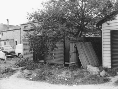
Photograph, Edwin G. Adamson A.R.P.S, Toilets in Civic Place, Ringwood, used by occupiers of 'The Block''. 1963 (Eastland Litigation Photo)
This series of SS0380 photos are part of the "Eastland Litigation" launched in 1962 by the Whitehorse Traders Co-operative Association (WTCA), against the Ringwood Council's Interim Development Order of 1960. WTCA sought "orders from the Supreme Court of Victoria that the planning scheme was invalid" - See "The Eastland Litigation" chapter in "From Horse Shoes to High Heels - Ringwood Shopping Centre and Eastland 1858-2008" by Richard Carter, Bounce Books 2009.Black and White PhotographWritten on back of photographs, 'Photo of toilets in Civic Place, used by occupiers of 'The Block''. Also stamped on photographs, 'Edwin G. Adamson...May 63' and 'In the Supreme Court, 1 Aug. 1963'. -
 Ringwood and District Historical Society
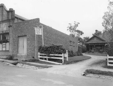
Photograph, Edwin G. Adamson A.R.P.S, Printery in Adelaide St. Ringwood intruding into the hospital grounds 1963 (Eastland Litigation Photo)
This series of SS0380 photos are part of the "Eastland Litigation" launched in 1962 by the Whitehorse Traders Co-operative Association (WTCA), against the Ringwood Council's Interim Development Order of 1960. WTCA sought "orders from the Supreme Court of Victoria that the planning scheme was invalid" - See "The Eastland Litigation" chapter in "From Horse Shoes to High Heels - Ringwood Shopping Centre and Eastland 1858-2008" by Richard Carter, Bounce Books 2009.Black and White PhotographWritten on back of photograph, 'Photo showing how the printery in Adelaide St. intrudes into the hospital grounds. See also how the printery extends back towards the hospital. Pines Hospital Adelaide St. next to "Mail" office'. Stamps on photographs read, 'Edwin G. Adamson...May 63' and 'In the Supreme Court 13 Aug. 1963'. -
 Ringwood and District Historical Society
Photograph, Edwin G. Adamson A.R.P.S, Toilets in Civic Place, Ringwood 1962 (Eastland Litigation Photos)
This series of SS0380 photos are part of the "Eastland Litigation" launched in 1962 by the Whitehorse Traders Co-operative Association (WTCA), against the Ringwood Council's Interim Development Order of 1960. WTCA sought "orders from the Supreme Court of Victoria that the planning scheme was invalid" - See "The Eastland Litigation" chapter in "From Horse Shoes to High Heels - Ringwood Shopping Centre and Eastland 1858-2008" by Richard Carter, Bounce Books 2009.2xBlack and WHite PhotographsWritten on back of photograph 2838-1: 'Photo of the toilets in Civic Place, showing doors broken off. See pan exposed to public view'. Stamped on photograph, 'Edwin G. Adamson...May 62'. Written on back of photograph 2838-2: 'Photo of the toilets in Civic Place, showing doors broken off where pans slide into toilets. Pans open to air, flies, etc. Used by occupiers of 'The Block'. Stamped on photographs, 'In the Supreme Court 13 Aug 1963' and 'Edwin G. Adamson...May 63'. -
 Ringwood and District Historical Society
Photograph, Edwin G. Adamson A.R.P.S, Front of "Mail" office and hospital Adelaide St, Ringwood 1963 (Eastland Litigation Photo), 1963
This series of SS0380 photos are part of the "Eastland Litigation" launched in 1962 by the Whitehorse Traders Co-operative Association (WTCA), against the Ringwood Council's Interim Development Order of 1960. WTCA sought "orders from the Supreme Court of Victoria that the planning scheme was invalid" - See "The Eastland Litigation" chapter in "From Horse Shoes to High Heels - Ringwood Shopping Centre and Eastland 1858-2008" by Richard Carter, Bounce Books 2009.Black and White PhotographWritten on back of photographs, 'Adelaide St. front of "Mail" office and hospital'. Also stamped on one copy:, 'In the Supreme Court E.W.L. 13 Aug. 1963' and 'Edwin G. Adamson'. -
 Ringwood and District Historical Society
Photograph, Byways Estate, Ringwood East, June 1965 (2 views)
Written on backing sheets (2 photos), "Byways Estate, Ringwood East, June 1965. C.E. Carter, agent. Prices 1850-2950 pounds, 33 lots. Byways Drive - Rex Court and Buronga Avenue". -
 Ringwood and District Historical Society
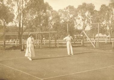
Photograph, Ringwood Tennis Courts, south-west corner of Ringwood Oval, 1920
Catalogue card reads, "Ringwood Tennis Courts, south-west corner of Ringwood Oval, 1920". (3 copies) -
 Ringwood and District Historical Society
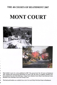
Book, The 48 Courts of Heathmont - Mont Court, 2007
... Road Ringwood North melbourne The 48 Courts of Heathmont - Mont ...The 48 Courts of Heathmont - Mont Court - part of a series published in 2007 -
 Ringwood and District Historical Society
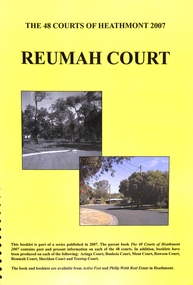
Book, The 48 Courts of Heathmont - Reumah Court, 2007
... Road Ringwood North melbourne The 48 Courts of Heathmont ...The 48 Courts of Heathmont - Reumah Court- part of a series published in 2007 -
 Ringwood and District Historical Society
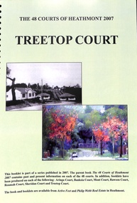
Badge - Book, The 48 Courts of Heathmont - Treetop Court, 2007
... Road Ringwood North melbourne The 48 Courts of Heathmont ...The 48 Courts of Heathmont - Treetop Court - part of a series published in 2007 -
 Ringwood and District Historical Society
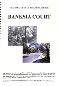
Book, The 48 Courts of Heathmont - Banksia Court, 2007
... Road Ringwood North melbourne The 48 Courts of Heathmont ...The 48 Courts of Heathmont - Banksia Court - part of a series published in 2007 -
 Ringwood and District Historical Society
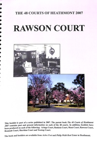
Book, The 48 Courts of Heathmont - Rawson Court, 2007
... Road Ringwood North melbourne The 48 Courts of Heathmont ...The 48 Courts of Heathmont - Rawson Court - part of a series published in 2007 -
 Ringwood and District Historical Society
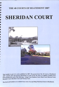
Book, The 48 Courts of Heathmont - Sheridan Court, 2007
... Road Ringwood North melbourne The 48 Courts of Heathmont ...The 48 Courts of Heathmont - Sheridan Court - part of a series published in 2007 -
 Ringwood and District Historical Society
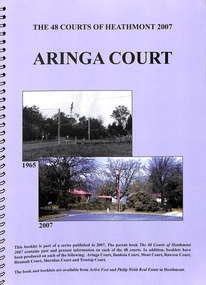
Book, The 48 Courts of Heathmont - Aringa Court, 2007
... Road Ringwood North melbourne The 48 Courts of Heathmont ...The 48 Courts of Heathmont - Aringa Court - part of a series published in 2007 -
 Ringwood and District Historical Society
Photograph, Salisbury Court, Heathmont, 1967
Written on back of photograph, "Salisbury Court, Heathmont, 1967". Stamp on back reads, "Bryan Dale, Photographer". -
 Ringwood and District Historical Society
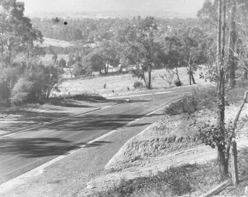
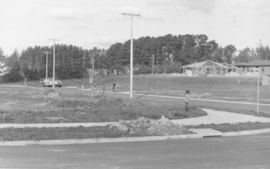
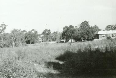
Photograph, View of corner of Middlebrook Dr and Tortice Drive looking east towards Wonga Rd, North Ringwood. 1981
Written on back of photograph, "24/8/81. View of corner of (Blank) court and Tortice Drive looking east towards Wonga Rd. Thought to be Middlebrook Drive, not a court. -
 Ringwood and District Historical Society
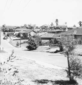
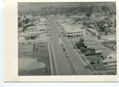
Photograph, Looking from parking area in front of Parkwood High School towards Wonga Road over new subdivision, North Ringwood, 1981
Written on back of photograph, "24.4.81 Looking from parking area in front of Parkwood High School towards Wonga Road over new subdivision. In the area seen there are six new courts under construction. Three months ago there was nothing there." -
 Ringwood and District Historical Society
Photograph, At bottom of Mullum Court, C of E building on right. Ringwood. Undated but possibly early 1970's
No date, but other photos in this group are 1971-1973Written on back of photograph, "At bottom of Mullum Court, C of E building on right." -
 Orbost & District Historical Society
black and white photographs, 1980s? (winter months)
All photographs seem to have been takenfrom the Telecom tower on the corner of Browning and Wolseley Streets in Orbost 3259.1 is a view of the Orbost township looking north-east. The swimming pool and bowling club can be seen in the foreground. 3259.2 is aview looking north-west and showing the tennis courts and clubhouse, the Recreation Reserve oval, the Youth Centre, Historical Museum, Municipal Offices, Senior Citizens clubrooms with the fire station in the foreground. 3259.3 is a view looking south with the Shire of Orbost Municipal offices and Ruskin Street in the foreground. Munro Street can be seen running from Ruskin Street to St Joseph's School in the middle distance. Lochiel Park oval, Lochiel House, the Snowy River and highway bridge are in the background. 3259.4 is a view looking south showing the Club Hotel, C.B.C. Bank in the middle distance and Hoffman's paddock (Forest Park) and the Snowy River beyond. 3259.5 is a view looking north-east over houses. 3259.6 is aview over the main street, Nicholson Street.showing the main shopping precinct. Shop signs for Permewans, Williams Shoes, F.B. Dicken and Orbost Bakery can be seen. 3259.7 is a view looking south west and shows Forest park and beyond towards Bete Bolong.These photographs are detailed pictorial records of the township of Orbost.Seven black / white photographs taken from above a township. Chimney smoke can be seen in the photographs.orbost-township-1980s aerial-photograph-orbost -
 Orbost & District Historical Society
black and white photographs, C 1960s - 1970s
3290.1 is an aerial photograph of the township of Orbost looking south along Nicholson Street. The tennis courts and recreation reserve are on the left. The War Memorial, Commonwealth Hotel at the Saisbury Street intersection is in the centre of the photograph. 3290.2 is an aerial view of the Orbost township looking north, showing the bridge across the Snowy River in the foreground,These photographs are detailed pictorial records of the Orbost township C 1960s - 1970s.Two photographs which are aerial views of a township showing streets, buildings and vehicles. 3290.1 is a black / white photograph. 3290.2 is a coloured photograph.orbost-township-c1960s-1970s aerial-photograph-orbost -
 Ringwood and District Historical Society
Pamphlet, Land Sale Brochure Titled Eureka Plan Book - Seven Delightful & Valuable Ringwood Estates - circa 1925
Twenty page land sale brochure including photographs, subdivision features and local facilities. Additional flyer with conditions of sale and prices for estate blocks.Seven delightful and valuable Ringwood Estates called Bestpart, Paradise, Hill Top, Greenwood, Creek, Station, and School Estates. These nestle amidst the hills and valleys of beautiful Ringwood district. Also Goodluck Estate at Clarinda. Pamphlet marked as being From Mr. Farmer, No. 5 Flinders Court, Melbourne. Phone 988, 989 Central, or 55 Ringwood after 7 p.m. Plan of Ringwood School Estate includes William Street (later Kendall Street), Greenwood Avenue, Alton Street and Locke Street. Plan of Bestpart Estate, Ringwood, includes Bedford Road, Wilana Street, Greenwood Avenue, Caroline Street, Henry Street and Haig Street. Plan of Ringwood Station Estate includes Pitt Street, Bedford Road, Greenwood Avenue, Station Street, William Street (later Kendall Street, James Street, Wantirna Road, Caroline Street, Henry Street, Ellison Street and Haig Street. Plan of Geenwood Estate, Ringwood, includes Prussian Road (later Geenwood Avenue). Plan of Paradise Estate, Ringwood, includes Canterbury Road, Dandenong Road (Wantirna Road), Luck Street and Paradise Road. Plan of Creek Estate, Ringwood, includes Dandenong Creek, Wantirna Road and Gordon Crescent. Plan of Hill Top Estate, Ringwood (later Heathmont area), includes Heathmont Railway Station, Heathmont Road, Balfour Avenue, Lilian Street, Edith Street, Edna Street and Great Ryrie Street. Plan of Goodluck Estate, Clarinda, includes Talbot Avenue, Good Street, Luck Street, and Centre Road in locality plan between Oakleigh and Clayton Railway Stations. -
 Ringwood and District Historical Society
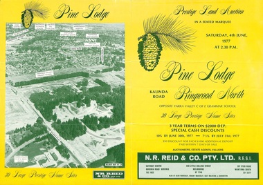
Flyer, Land Auction Sale Brochure, Pine Lodge, Ringwood North, Victoria - 1977
Refer also to Reg. No. 5172 for Pine Lodge Land Auction 3rd release, 1978.Yellow double-sided real estate auction notice with green print showing aerial photograph and map of subdivision layout and summary of local features and services for Pine Lodge, Kalinda Road, Ringwood North. Auction date, Saturday, 4th June, 1977, at 2:30pm.Subdivision plan includes Parkgate Drive, Wood-Church Close, and Pensby Court. (Agent) N.R. Reid & Co. Pty. Ltd., Safeway Centre, Boronia Road, Boronia (Phone) 762 1022, 450 Little Collins Street, Melbourne (Phone) 67 1746, and 207 Stud Road, Wantirna South (Phone) 231 2277. -
 Ringwood and District Historical Society
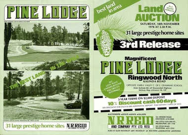
Flyer, Land Auction Sale Brochure, Pine Lodge, Ringwood North, Victoria - 3rd Release 1978
Refer also to Reg. No. 5171 for Pine Lodge Land Auction previous release, 1977.Green tri-fold advertisement for auction of home sites, with map of subdivision, photographs, and summary of local features and services for Pine Lodge, Kalinda Road, Ringwood North - 3rd release - Auction date, Saturday, 18th November, 1978, at 2:30pm.Subdivision plan includes Mundara Drive, Bidston Court, Parkgate Drive, Frodsham Road, and Bebington Close. (Agent) N.R. Reid & Co. Pty. Ltd., 10A Hewish Road, Croydon (Phone) 725 0999, 450 Little Collins Street, Melbourne (Phone) 67 1746, and 207 Stud Road, Wantirna South (Phone) 221 2222. -
 Ringwood and District Historical Society
Flyer, Land Auction Sale Brochure, Proclamation Estate, Ringwood, Victoria - circa 1963
Land sale auction advertisement - Proclamation Estate, Ringwood, with map of subdivision and summary of local features and services. Auction date, Saturday, March 2, (1963?), at 2pm.Subdivision plan includes Maidstone Street, Stanhope Court, Wrights Court, and Watirna Road. (Agents) Blackburn & Lockwood in conjunction with C.E. Carter & Son, 126 Whitehorse Road, Ringwood (Phone) 87 6024. -
 Ringwood and District Historical Society
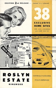
Flyer, Land Sale Brochure - Roslyn Estate, Ringwood, Vic. - circa 1960s
Land sale advertisement for 2nd release of residential sites with area map, layout of the estate, terms of sale, and summary of local facilities and services.Subdivision includes Daisy Street, Vale Street, Joan Court, Christine Court, and Westmore Drive. (Agent) Heathmont Estate Agency, 103 Canterbury Road, Heathmont. (Phone) WU7808-9. Brochure also includes map with streets marked as "Sold" - Reilly Street, Adrian Court, Daisy Street, Jarma Road, Joel Court, and Ross Court, with comment that "all home sites in the first release have already been sold, and most built on." -
 Ringwood and District Historical Society
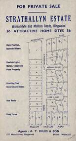
Flyer, Land Sale Advertisement - Strathallyn Estate, Ringwood, Victoria - circa 1950
Advertisement for private sale of 36 home sites in the Warrandyte Road and Mullum Mullum Road area of Ringwood, with map showing layout of subdivision and summary of local features and services. Handwritten notation indicates May, 1950.Subdivision includes Warrandyte Road, Strathallyn Road, Norman Court, Lade Court, and Mullum Mullum Road. Agents: A.T. Miles & Son, 175 Main Street, Ringwood, Phone WU6215. -
 Ringwood and District Historical Society
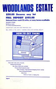
Flyer, Land Sale Advertisement - Woodlands Estate, North Ringwood, Victoria - circa 1970
Double sided single-page advertisement for land sale with locality map and layout of Woodlands Estate subdivision in North Ringwood, with summary of local features and services. No indication of date of flyer other than post-Eastland Shopping Centre opening in 1967.Subdivision includes Oban Road, Terrigal Close, Dorelaw Drive (later Melview Drive), Naroo Court, and Barook Court. Agent's rubber stamp imprint - H.C. Walton & Son, 264 Doncaster Road, North Balwyn.