Showing 585 items
matching old maps
-
 Victorian Aboriginal Corporation for Languages
Periodical, Australian Institute of Aboriginal and Torres Strait Islander Studies, Australian Aboriginal studies : journal of the Australian Institute of Aboriginal and Torres Strait Islander Studies, 2010
Mediating conflict in the age of Native Title Peter Sutton (The University of Adelaide and South Australian Museum) Mediators have played roles in managing conflict in Aboriginal societies for a long time. This paper discusses some of the similarities and differences between older customary mediator roles and those of the modern Native Title process. Determinants of tribunal outcomes for Indigenous footballers Neil Brewer, Carla Welsh and Jenny Williams (School of Psychology, Flinders University) This paper reports on a study that examined whether football tribunal members? judgments concerning players? alleged misdemeanours on the sporting field are likely to be shaped by extra-evidential factors that disadvantage players from Indigenous backgrounds. Indigenous and non-Indigenous Australian Football League (AFL) players, matched in terms of their typical levels of confidence and demeanour in public situations, were interrogated in a mock tribunal hearing about a hypothetical incident on the football field. The specific aim was to determine if the pressures of such questioning elicited behavioural differences likely to be interpreted as indicative of testimonial unreliability. Mock tribunal members (number = 103) then made judgments about the degree to which a number of behavioural characteristics were evident in the players? testimonies. Under intense interrogation, Indigenous players were judged as presenting less confidently and displaying a greater degree of gaze aversion than non-Indigenous players. These behavioural characteristics are commonly ? and inappropriately ? used as cues or heuristics to infer testimonial accuracy. The paper discusses the implications for Indigenous players appearing at tribunal hearings ? and for the justice system more broadly. Timothy Korkanoon: A child artist at the Merri Creek Baptist Aboriginal School, Melbourne, Victoria, 1846?47 ? a new interpretation of his life and work Ian D Clark (School of Business, University of Ballarat) This paper is concerned with the Coranderrk Aboriginal artist Timothy Korkanoon. Research has uncovered more about his life before he settled at the Coranderrk station in 1863. Evidence is provided that five sketches acquired by George Augustus Robinson, the former Chief Protector of Aborigines, in November 1851 in Melbourne, and found in his papers in the State Library of New South Wales, may also be attributed to the work of the young Korkanoon when he was a student at the Merri Creek Baptist Aboriginal School from 1846 to 1847. Developing a database for Australian Indigenous kinship terminology: The AustKin project Laurent Dousset (CREDO, and CNRS, Ecole des Hautes Etudes en Sciences Sociales), Rachel Hendery (The Australian National University), Claire Bowern (Yale University), Harold Koch (The Australian National University) and Patrick McConvell (The Australian National University) In order to make Australian Indigenous kinship vocabulary from hundreds of sources comparable, searchable and accessible for research and community purposes, we have developed a database that collates these resources. The creation of such a database brings with it technical, theoretical and practical challenges, some of which also apply to other research projects that collect and compare large amounts of Australian language data, and some of which apply to any database project in the humanities or social sciences. Our project has sought to overcome these challenges by adopting a modular, object-oriented, incremental programming approach, by keeping metadata, data and analysis sharply distinguished, and through ongoing consultation between programmers, linguists and communities. In this paper we report on the challenges and solutions we have come across and the lessons that can be drawn from our experience for other social science database projects, particularly in Australia. A time for change? Indigenous heritage values and management practice in the Coorong and Lower Murray Lakes region, South Australia Lynley A Wallis (Aboriginal Environments Research Centre, The University of Queensland) and Alice C Gorman (Department of Archaeology, Flinders University) The Coorong and Lower Murray Lakes in South Australia have long been recognised under the Ramsar Convention for their natural heritage values. Less well known is the fact that this area also has high social and cultural values, encompassing the traditional lands and waters (ruwe) of the Ngarrindjeri Nation. This unique ecosystem is currently teetering on the verge of collapse, a situation arguably brought about by prolonged drought after decades of unsustainable management practices. While at the federal level there have been moves to better integrate typically disparate ?cultural? and ?natural? heritage management regimes ? thereby supporting Indigenous groups in their attempts to gain a greater voice in how their traditional country is managed ? the distance has not yet been bridged in the Coorong. Here, current management planning continues to emphasise natural heritage values, with limited practical integration of cultural values or Ngarrindjeri viewpoints. As the future of the Coorong and Lower Murray Lakes is being debated, we suggest decision makers would do well to look to the Ngarrindjeri for guidance on the integration of natural and cultural values in management regimes as a vital step towards securing the long-term ecological viability of this iconic part of Australia. Hearts and minds: Evolving understandings of chronic cardiovascular disease in Aboriginal and Torres Strait Islander populations Ernest Hunter (Queensland Health and James Cook University) Using the experience and reflections of a non-Indigenous clinician and researcher, Randolph Spargo, who has worked in remote Aboriginal Australia for more than 40 years, this paper tracks how those at the clinical coal-face thought and responded as cardiovascular and other chronic diseases emerged as new health concerns in the 1970s to become major contributors to the burden of excess ill health across Indigenous Australia. The paper cites research evidence that informed prevailing paradigms drawing primarily on work in which the clinician participated, which was undertaken in the remote Kimberley region in the north of Western Australia. Two reports, one relating to the Narcoonie quarry in the Strzelecki Desert and the other concerning problematic alcohol use in urban settings.maps, b&w photographs, colour photographs, tablesstrzelecki desert, native title, timothy korkanoon, merri creek baptist aboriginal school, austkin project, coorong, lower murray lakes district, south australia, indigenous health -
 Victorian Aboriginal Corporation for Languages
Periodical, Australian National University Department of Pacific and Southeast Asian History, Aboriginal history, 1988
... b&w photographs, maps, reproductions of old materials... Street Brunswick melbourne b&w photographs, maps, reproductions ...b&w photographs, maps, reproductions of old materials -
 Victorian Aboriginal Corporation for Languages
Book, Edgar Morrison, The Loddon Aborigines : tales of old Jim Crow, 1971
This regional survey is the last of a trilogy, each of which deals with a particular aspect of living conditions and racial relationships in the Loddon watershed in the early Colonial days.maps, b&w photographsloddon -
 Victorian Aboriginal Corporation for Languages
Book, Luise Hercus, This is what happened : historical narratives by Aborigines, 1986
This book is devoted to the contact history of a hunting and gathering people where they themselves tell the stories in their own languages. Presented as transcriptions of the original stories in Language in facsimile with introductions, gloss and translations by the transcribers. Contains stories by B. Kerwin, R. Moses, H.P. Kulambunt. B. Roberts, M.M. Irinjili D. Harris, J.S. Karntin, C.G. Wurramarrba, Barrengwa, B. Murray, W. Clegg, S. Day, T. Ejai, A. Baranga, I. Joshua, B. Clarmont and C. Omeenyo, H. Goetz, A. Coulthard, J. Boxer; (Lalarin), B.A. Sommer, J. Jack, E. Kennedy, L.J. Kyngayari, V. Lingiari, J.C. Maliwanga and J. Flinders, separately annotated.maps, b&w photographs, word listsyandruwandha, innamicka, nicholson river, djaru, wawarl, western dialect, murinypata, alawa, mission, wangganguru, ngiyambaa, cobar, cape keerweer, wik-ngatharra, macassar, anindilyakwa, dhirari, afghan, chinaman, wagaya, wemba wemba, bilikin brothers, bardi, ngarinjin, massacres, hodgson downs, warndarang, mindiri, wangganguru, old paddy, umpila, native police, gugu-badhun, boninb, atynyamatana, constable mcleay, bowman, oykangand, kukatj, roper creole, paradise, dhirari, fanny brown, wave hill strike, gurindji, vincent lingiari, mainoru station, rembarrnga, land rights, flinders island -
 Victorian Aboriginal Corporation for Languages
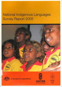
Book, Australian Institute of Aboriginal and Torres Strait Islander Studies, National Indigenous languages survey report 2005, 2005
The National Indigenous Languages Survey Report 2005 highlights that: of an original estimated 250 known Australian Indigenous languages, only 18 languages are now considered 'strong' and have speakers in all age groups; about 110 Indigenous languages are still spoken by older people but are endangered; words and phrases are still in use and there is community support in many parts of the country for reclamation and learning programs for many other languages which are no longer fully spoken; communities around Australia possess many of the elements required to keep Indigenous languages strong or to reclaim them. They have skilled and devoted language workers and teachers, excellent teaching materials, good documentation of languages and active community language centresmaps, colour photographs, tables, graphsaboriginal english, education, aiatsis, fatsil, language endangerment, language maintenance, language revival, language policy, language proficiency -
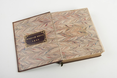 Uniting Church Archives - Synod of Victoria
Book - Bible, Archibald Fullerton & Co, Hawei's Bible, 1837
BL005.1 and BL005.2 brown leather hard covered book with gilt borders and text on the spines. The bibles have a printed label inside the front covers. B005.1 Vol 1 The Holy Bible with notes, references and practical observations. Includes maps and monochrome plates. From Genesis to Esther. B005.2 Vol 3 The evangelical expositor : or, a commentary on the Holy Bible : wherein the sacred text of the Old and New Testaments is explained and elucidated, with practical observations for the use of families / by the Rev. Thomas Haweis."WILLIAM BETTS 1840"hawei's bible, william betts 1840 -
 Sunshine and District Historical Society Incorporated
Map (1967), CITY OF SUNSHINE, June 1967, 1967
The City of Sunshine no longer exists. Part of the eastern area has been annexed by the City of Maribyrnong, and the rest of the old City of Sunshine has been amalgamated with the City of Keilor to form the larger City of Brimbank.This 1967 map is a historical record of the City of Sunshine as it existed 27 years before the amalgamation of Councils, and the creation of the City of Brimbank in 1994.Whitish paper map with black printing that is laminated in clear plastic film, and has a wood slat attached to the top edge. The June 1967 map is of the previous CITY OF SUNSHINE showing City and Parish boundaries, streets, railways, creeks, river etc.Purple ink stamps at top left hand and right hand areas showing address and contact details of 'Sunshine Industrial Promotion Centre.'city of sunshine, june 1967, map, city, parish, boundaries, brimbank -
Stawell Historical Society Inc
Map, Borough of Stawell Parish of Stawell and Illawarra 10/06/1903, 10/06/1903
Department of Lands and Survey Map of Stawell with marked roads, allotments, physical landmarks. Found in Storage at ANZ Bank when the old archive was being cleaned out. Also shows Surveyed but unused roads. Showed where customers lived in StawellPholtolithograph Map - Paper on canvas backingBorough of Stawell. Parish of Stawell and Illawarra. County of Borong. Scale 8 Chains to 1 Inch. Scale 16 Chains to 1 Inch. Red Ink Writing, Purple and Blue.town -
Stawell Historical Society Inc
Map, Easton Johnstone, Map of Stawell Surveyed by Easton Johnstone 1872, 1872
Victoria Co Crushing Machine. St Georges Co Crushing machine. Wimmera Co Crushing Machine. Government Reservoir and Drainage. Sloan Street, Skene Street Mines. old Mine WorkingsA2 map of Stawell Reefs Area. Showing Crushing Machines & Title InfoSurveyed by Easton Johnstone Contract Surveyor. Photo-Lithographed at the Department of Lands & Survey. Melbourne By J Noone 9th May 1872mining -
Stawell Historical Society Inc
Map, MPI Mines, Plan View of Township Area 2003, 13/6/2003
goldShowing known old gold workings Stawell Gold Mines. 13 June 2003 1 : 7500 MPI Minesmining -
Koorie Heritage Trust
Book, Abdulla, Ian W, As I grew older : the life and times of a Nunga growing up along the River Murray, 1993
As I Grew Older affirms the culture of rural Aborigines who, despite being dispossessed, have been determined to stay onb their own land. The painting of Ian Abdulla offer us a window on to the life of an Aboriginal Family on the Murray River in the mid-twentieth century.40 unnumbered pages : colour illustrations, 1 colour map ; 26 x 31 cm.As I Grew Older affirms the culture of rural Aborigines who, despite being dispossessed, have been determined to stay onb their own land. The painting of Ian Abdulla offer us a window on to the life of an Aboriginal Family on the Murray River in the mid-twentieth century.abdulla, ian w., 1947-2011. | aboriginal australians -- murray river region (n.s.w.-s.a.) -- biography. | aboriginal australians -- south australia -- juvenile literature. | aboriginal australians, in art -- juvenile literature. | painting, aboriginal australian -- south australia -- juvenile literature. | murray river region (n.s.w.-s.a.) -- biography. | australian -
Koorie Heritage Trust
Book, Barwick, Diane et. al, Handbook for Aboriginal and Islander history, 1979
Contents: Archaeology Isabel McBryde; Archives H.J. Gibbney; Artefacts and museums Carol Cooper, Isabel McBryde; Australian Institute of Aboriginal Studies Diane Barwick, Jane Forge, James Urry; Biography: writing a life story Diane Barwick, Nan Phillips, Tom Stannage; Censuses and other population records L.R. Smith; Court and police records: evidence for Aboriginal history Tom Stannage; Genealogy: tracing family history Diane Barwick, Diane Bell, Francesca Merlan; Government - Government publications on Aborigines Brownlee Kirkpatrick; Government committees and Royal Commissions David H. Bennett. Guardians of history - Aboriginal heritage and the Australian Heritage Commission Josephine Flood; Historical Societies Nan Phillips, Tom Stannage. Land rights - Land rights: recent events and legislation Anita Campbell, Diane Bell, Diane Barwick; Land rights: an introductory bibliography Nicolas Peterson. Language: resources for research Luise Hercus, Francesca Merlan; Libraries James Urry; Maps and mapping John von Sturmer; Missions: settlements, sponsors, sources of information James Urry; Music Alice Moyle; Newspapers Andrew Markus; Oral history interviewing Peter Read; Photographic records - Koorie studies: records of the South Coast Yuin walkabout Guboo Ted Thomas; Photographs old and new Colin Roach; Films and film-making David McDougall; Publishing your work Shirley Andrew, Diane Barwick; Sport: resources for research Michael Mace, Bill Rosser; Tape recording Bryan Butler; Torres Strait Islands: information available in Papua New Guinea Peter Bolger; War and Aborigines Hank Nelson; Women in Aboriginal society: resources for research Diane Barwick, Diane Bell.xv, 187 p. ; 25 cm.Contents: Archaeology Isabel McBryde; Archives H.J. Gibbney; Artefacts and museums Carol Cooper, Isabel McBryde; Australian Institute of Aboriginal Studies Diane Barwick, Jane Forge, James Urry; Biography: writing a life story Diane Barwick, Nan Phillips, Tom Stannage; Censuses and other population records L.R. Smith; Court and police records: evidence for Aboriginal history Tom Stannage; Genealogy: tracing family history Diane Barwick, Diane Bell, Francesca Merlan; Government - Government publications on Aborigines Brownlee Kirkpatrick; Government committees and Royal Commissions David H. Bennett. Guardians of history - Aboriginal heritage and the Australian Heritage Commission Josephine Flood; Historical Societies Nan Phillips, Tom Stannage. Land rights - Land rights: recent events and legislation Anita Campbell, Diane Bell, Diane Barwick; Land rights: an introductory bibliography Nicolas Peterson. Language: resources for research Luise Hercus, Francesca Merlan; Libraries James Urry; Maps and mapping John von Sturmer; Missions: settlements, sponsors, sources of information James Urry; Music Alice Moyle; Newspapers Andrew Markus; Oral history interviewing Peter Read; Photographic records - Koorie studies: records of the South Coast Yuin walkabout Guboo Ted Thomas; Photographs old and new Colin Roach; Films and film-making David McDougall; Publishing your work Shirley Andrew, Diane Barwick; Sport: resources for research Michael Mace, Bill Rosser; Tape recording Bryan Butler; Torres Strait Islands: information available in Papua New Guinea Peter Bolger; War and Aborigines Hank Nelson; Women in Aboriginal society: resources for research Diane Barwick, Diane Bell.australian aborigines, to 1979. historical sources. | aborigines, australian -- history. | genealogy. | torres strait islanders -- history -- sources. | aboriginal australians -- genealogy. | aboriginal australians -- history -- sources. | aboriginal australians -- history. | aboriginal australians -- history -- archival resources. | aboriginal australians -- history -- library resources. | aboriginal australians -- history -- bibliography. -
Whitehorse Historical Society Inc.
Map, Shires of Boroondara, Nunawading, C1856
Photocopy of part of very early map covering parts of Boroondara and Nunawading.Photocopy of part of very early map covering parts of Boroondara and Nunawading. Marks old tracks on lines of Whitehorse and Canterbury Roads.Photocopy of part of very early map covering parts of Boroondara and Nunawading.maps, shire of nunawading, shire of boroondara, barkers track, deep creek, nunawading -
Whitehorse Historical Society Inc.
Map, Aspinall's old abattoirs, Box Hill, 1937
... drawn plan of subdivision of old abattoirs site, Woodhouse Grove ...Hand drawn plan of subdivision of old abattoirs site, Woodhouse Grove, Box Hill North.Hand drawn plan of subdivision of old abattoirs site, Woodhouse Grove, Box Hill North.Hand drawn plan of subdivision of old abattoirs site, Woodhouse Grove, Box Hill North.land subdivision, aspinall's estate, woodhouse grove, box hill north, aspinall road, box hill north, abattoirs -
 Whitehorse Historical Society Inc.
Map, Schwerkolt property and rough plan of old stone house, 1993
... of old stone house Map Map ...Map drawn by Arthur SchwerkoltMap drawn by Arthur Schwerkolt in 1993 from memory assisted by survey map of 1902. Covering letter from Glyn France [also at ND1367 (G-H-S-C 46) gives extra details.Map drawn by Arthur Schwerkoltschwerkolt cottage, schwerkolt, arthur, whalen, rosalie, france, glyn -
Whitehorse Historical Society Inc.
Document, Box Hill History Kit
Box Hill History Kit published by Box Hill Historical Society and Box Hill City Council.Box Hill History Kit published by Box Hill Historical Society and Box Hill City Council. Contents include Brochures, First Box Hill Railway Time Table, copies of Box Hill & Doncaster Tramway Tram and old photos taken around Box Hill, Tom Roberts Artists' Camp, 1905 Map of Box Hill etc.Box Hill History Kit published by Box Hill Historical Society and Box Hill City Council. box hill historical society, box hill city council -
Whitehorse Historical Society Inc.
Document - Correspondence, Letter and Map Schwerkolt houses, 9/11/1993
Letter to W. Gray, Nunawading Historical Society from Glyn France enclosing map of Schwerkolt property and rough plan of old stone house drawn by Arthur Schwerkolt [map filed at A-SP 120]. Gives information about dates of building 'old' and 'new' houses.schwerkolt, arthur, schwerkolt, myra, france glyn, schwerkolt cottage -
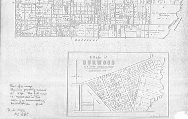 Whitehorse Historical Society Inc.
document - Map, Village of Burwood, 1892
Map on the village of Burwood.Village of Burwood : old name Ballyshanassy (with southern section of Nunawading). Area bounded by Chapman, Ireland and Evans Streets). Victorian Shire Map. co. 26 November 1892. Scale: 8 chains = 1 inch. The full map is reproduced in 'The History of Nunawading' by Niall Brennan, p. 62.Map on the village of Burwood.burwood, land settlement -
Unions Ballarat
Camp Street, Ballarat from Eureka to Federation : a guide to its history and buildings, 2001
A guide to the history of Camp Street Ballarat and its historical buildings. Camp Street has been the location of Unions Ballarat since 1887 - a chapter of the book is dedicated to Trades Hall - and was the home of the former labour newspaper, the Evening Echo. Camp Street was the site of the government camp at the time of the Eureka Stockade. Camp Street is now recognised as an Arts and Education precinct within the city of Ballarat. Headings: Gold fever The CAMPSTREET Project Titanic Bandstand Old Ballarat Free Library Complex "Point to the sky" "Perseus" Former government offices and court house Old Ballarat Court House Alfred Deakin Place Old Police Station (Ballarat Fine Art Gallery) Ballarat Fine Art Gallery Millennium Extension Bluestone Warehouse (Pratt's Warehouse) Old YMCA building Wilson House Ballarat Office Systems Ballarat Trades Hall The ANA Building Freemason's Hall Former Ballarat Trustees and Executors Agency Co. Ltd. Restaurant Former Evening Echo Building Ballarat Savings Bank (now The Ballarat Business Centre) Significant to the history of architecture and social life within the city of Ballarat. Direct relevance to Unions Ballarat building.Book; 48 pages. Cover: blue background; colour photos and maps pertinent to Ballarat; white lettering; title and compiler's name. btlc, ballarat trades hall, ballarat trades and labour council, evening echo, ballarat savings bank, ballarat business centre, freemason's hall - ballarat, ana building - ballarat, ballarat - camp street, wilson house - ballarat, ballarat office systems, ymca building, pratt's warehouse - ballarat, ballarat fine art gallery, old police station - ballarat, alfred deakin place, old courthouse - ballarat, perseus, point to the sky, old ballarat free library complex, titanic bandstand, campstreet project, gold mining - ballarat, architecture - history - ballarat -
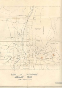 Old Castlemaine Schoolboys Association Inc.
Map, Locality of Castlemaine
-
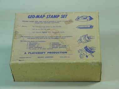 Old School House Museum
Rubber Stamp Set
Used by teachers for teaching geography, they would take the plate and attach to the handle, stamp it into ink and would make multiple copies for the students to either identify capital and countries or to learn the shape and localities of each locationIt was an early way of making multiple copies for teaching students.Geography stamp set in box which include 4 plates and handle. Plates include, Asia,Africa,Victoria,The world Geo-Map Stamp Setfrankston primary school, rubber stamps, education, geo-map, victoria, asia, the world, africa, playcraft production -
 Inverloch Historical Society
000715 - Photograph - 1997 - Old Outtrim - Map - Nancye Durham
... 000715 - Photograph - 1997 - Old Outtrim - Map - Nancye...) Inverloch gippsland 000715 - Photograph - 1997 - Old Outtrim - Map ... -
 Numurkah & District Historical Society
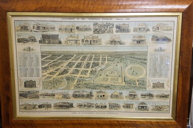
Map - Print in frame - Numurkah Township 1888, Supplement to the "Numurkah Standard" January 1888 View of Numurkah Victoria Australia
The late Hilda Morieson (very active in early Historical Society) owned the print. It was then passed on to Mary Morieson, then to Rosemary Kennet. It has been passed onto the Historical Society with permission from Ben Morieson, Hilda's grandsonLarge coloured print of supplement to Numurkah Standard 1888. Artist's view/impression of Numurkah streets (map) surrounded by artwork of a number of Numurkah businesses in the town and local district. The print is under glass in a faux-wood-grained framesee photo abovenumurkah standard, numurkah township map, numurkah businesses, 1888, print -
 Numurkah & District Historical Society
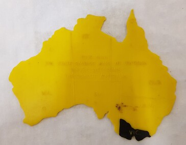
Equipment - Plastic stencil map/shape of Austalia
Yellow plastic stencil in the shape of Australia, states marked on the map, Victoria painted in blackState Savings Bank of Victoraeducation, school, geography, australia, stencil, drawing -
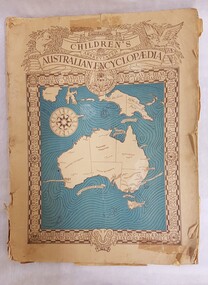 Numurkah & District Historical Society
Book - Children's Encyclopedia, The Sanitarium Children's Abbreviated Australian Encyclopedia (1947)
Paper-covered book with map of Australia on the front coversee photoeducation, school, encyclopedia, general knowlege -
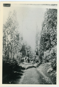 Mt Dandenong & District Historical Society Inc.
Photograph, Farringdon Road
Mt Dandenong Road (CRB Road, New Road, Main Road) was begun in the early 1920s and completed c1926. This would be a very early photograph in the history of the road and shows a Jeeves coach travelling along the new road at the base of Farringdon Road in Kalorama. Ellis Jeeves established the coach sevice between Kalorama and Croydon in 1904. It originally travelled down the Old Coach Road. John Lundy-Clarke grew up in the Kalorama/Mt Dandenong area and later in life (1972-74) began to write a comprehensive history of the area working from an original settlement map in an effort to cover all areas.Black and white photograph looking down an unmade road showing a coach travelling along another unmade road at the bottom. Roads are tree lined. handwritten inscription on reverse by John Lundy-Clarke.1920 Farringdon Road, looking at Jeeves Coach on Mt Dandenong Road.mt dandenong road, crb road, farringdon road, jeeves, ellis jeeves, coach, mt dandenong tourist road, kalorama -
Moorabbin Air Museum
Souvenir (Item) - Ansett - Souvenir of Ansett & TAA inflight menus and old tickets AND Qantas route maps & menus
-
Ballarat Tramway Museum
Map, Ballarat Litho & Printing Co, "Electoral Map of Ballarat", 1920's?
Map showing the electoral boundaries of Ballarat - State? - possibly early 1920's. Has been marked up in blue pencil for electric and horse tram routes around Ballarat, along with names of terminals, depot, and other points of interest. Shows horse trams lines in Macarthur St and Armstrong St. Also has in pencil, approximate location of the railway to Buninyong. Map shows location of Showgrounds (old location), Hospital for epileptics, abattoirs, but does not show Ballarat North Railway Workshops. Title Block "Ballarat Litho & Ptg. Cos. / Electoral Map of / Ballarat / Scale 20 chains to One Inch" To be stored with minimal folding.trams, tramways, map, ballarat, horse trams -
 Ballarat Tramway Museum
Book, H.P. James, "In Other Days", late 1930's
ESCo Employee Hours Work Record book that has been used by an ESCo/SEC inspector, H. P. James as a record / note book for his personal collection or papers or journal titled "In Other Days". Book sewn with string in 36 page sections, blank end papers, board covers with stipple paper out sides and Rexene cloth binding. Comprising plain paper end papers and 104 printed pages (52 leaves), with each sheet printed in black on feint ruled paper for recording the hours worked and other details of drivers and conductors employed by ESCo. Printed for daily use, with Day and date page headings - made out for the 1930's. Text generically printed feint ruled paper. Images: Book - i1 Inside front cover - i2 Members Certificate - i3 Photo of H.P. James and index page - i4 Has been used to gather mementos such as photos, articles, newspaper clippings, letters and other miscellaneous documents on Ballarat local history. Newspaper cuttings etc often have side notes written by Mr. James. Inside front cover has certificate recording Mr. James membership to the Ballarat Historical Society (on Australasian Historical Record Society paper) for 1937 - 1938. A side note records Mr. James elected as Vice President in 1939. Receipt signed by Edward Crimmins (See Reg. Item 2486) Has a table of contents for pages 1 to 65. Opposite is a photograph of Mr. James dressed for the Ballarat Tramways Social Club function - See Reg. Item No. 506 Primary items are: 1 - Newspaper cutting "A stroll along Bridge St. 50 years ago" - Nathan F. Speilvogel. 3 - Newspaper cutting "What I Remember of Early Ballarat" - James Sainsberry. 4 - Newspaper cutting "Magnet that Made Ballarat - New Monument Marks Gold Discovery" 7 - Newspaper cutting "Romance of a Ballarat Street Block" - Speilvogel 9 - Newspaper cutting "Sixty years of Dana St. School"- Speilvogel 11 - Newspaper cutting "The White Flat - its Transitions of Service - Historical Review" - J. Hargreaves 15 - Newspaper cutting "Memories of Russell Square - Fireman's Carnivals" - James 16 - Notes on the Alfred Hall 17 - Newspaper cutting - "Alfred Hall" - James 21 - Letter re Russell Square dated 24/2/38, J. McLeish 23 - Newspaper cutting "The First Train to Ballarat" 25 - Newspaper cutting "Story of Ballarat's Horse Trams 1887 to 1913", James - see Reg. Item 2489. 27 - Photos and Newspaper cutting of items re horse trams, and photo of ESCo No. 18 - See Reg. Items 2490, 2491 and 2492. 28 - ESCo opening ticket (See other Reg. Items 608 for examples of this) ticket No. 1595. 29 - Newspaper cutting "Story of Ballarat's Electric Trams", James, See Reg. Item 2493. 30 - Poster - SEC - Ballarat "The New System of Fares and Sections" - 3/10/1997 - See Reg. Item 2494. SEC - Tourist Ticket - See Reg. Item 2495 ESCo - 3d check ticket - See Reg. Item 2496 31 - Tickets and handwritten notes - with reference to page 51 ESCo 1d - See Reg. Item 2497 (2 No.) ESCo/SEC? - lunch hour weekly ticket - See Reg. Item 2498 ESCo/SEC? - Morning and evening weekly ticket - See Reg. Item 2499 ESCo/SEC? - 3d Adult Transfer - See Reg. Item 2500 ESCo/SEC? - 2d child Transfer - See Reg. Item 2501 ESCo - 1.1/2 child ticket - See Reg. Item 2502 ESCo - 3d Adult ticket - See Reg. Item 2503 Extract of an item titled "History of Ballarat Tramways", SEC Magazine, Feb. 1939 - See Reg. Item 2504 2d ESCo token (See other reg items 1794 and 1943 for details of this object) - sewn into page. 33 - Handwritten notes "Alfred Hall" 35 - Handwritten notes "Russell Square" 36, 37 - miscellaneous cuttings from the Courier for 1939 and 1940 39 - Newspaper cutting "South Street Band Contests" - cutting dated 27/10/1932. (See images - i5 to 41, 43, - ditto - contest results 44 - Photo of the Tramway Shelter in Sturt Street being removed - Courier dated 18/12/1923 - see Reg Item 2523. 45 - Extract of April 1938 from SEC Magazine, photos of the launch of the illuminated Ballarat Centenary tram - see Reg Item 2524. 47 - Newspaper cutting "Peeps into the Past" 48 - Listing of "Members of Returned Soldiers Band", Ballarat, dated 18/11/1919. 49 - Newspaper cutting "Ballarat, The Home of the Band Contests", dated 27/10/1932. 51 - Handwritten notes - "Tram Fares methods of collection" - See Reg. Item 2505. 53 - Newspaper cutting "100 years ago", Port Phillip Herald for 1840. 54 - Black and white photo of a gathering of people (tramway?) at the Showgrounds - See Reg. Item 2506 55 - Six black and white photos with handwritten notes ESCo 19 or 20 - See Reg. Item 2507 Group of ESCo employees by ESCo tram - See Reg. Item 2508 Photo of ESCo employee, Si Barker - See Reg. Item 2509 Photo of ESCo company bus - See Reg. Item 2510 (See also Reg Item 3813) Photo of No. 25 - Barkly St - See Reg. Item 2511 Photo of two ESCo employees - See Reg. Item 2512 56 - Loose newspaper cutting "San Francisco Struggle Buggies" - cable trams - The Age 15/3/1947 57 - Letter from Mr. Pringle of ESCo to Inspector James and Handwritten notes on ESCo management - See Reg. Item 2513 Handwritten notes on the token systems - See Reg. Item 2514 59 - Page titled "Bundy clocks and meters" but no notes 61 - Hand drawn map of Ballarat tramways with notes on tracks - horse, SEC and ESCo and loops - See Reg. Item 2515. 63 - Miscellaneous newspaper cuttings and photo of the Arch of Victory 64 - Photo of W. J.K. Dunstan ??? (has notes written on back, but difficult to read)* - Notes on rear of photo p64. "49 years in service W.J.K. Dunstan Office Manager Ballarat Branch Retired 18/3/46" 65 - Newspaper cutting "Old Victorian Schooldays, letters and reminiscences by past scholars". 67 - Newspaper cuttings - photo of Ballarat Choral Union and Urquhart St. school 69 - Newspaper cutting "Saint with a top hat" 71, 73 - Newspaper cutting "District Mining Disasters of By-Gone Days" - John Hargreaves 75 - Newspaper cutting "The Ballarat Courier" banners for 2/9/1939 - outbreak of World War Two - normal and a special edition. 77, 79 - Newspaper cutting "My Youth in Ballarat" - T.P. Long. 81 - Two photos and handwritten notes showing trams in Sturt St and the line up of horse trams - See Reg Item 2516. 83 - Newspaper cutting "Theatrical History - The Charlie Napier" - Speilvogel 85, 87 - Newspaper cutting "Story of the Eureka Stockade Monument" - Speilvogel 89 - Newspaper cutting "The Beginning of Buninyong" - Speilvogel 91 - Newspaper cutting "St. David's Day" 93, 95 - Newspaper cutting "From 1856 to 1894, Ballarat's Foremost Citizen Major (William Collard) Smith Recalled - J. Hargreaves. 97 - Newspaper cutting "All Electrical Exhibition / Ballarat's Electric Supply, its development" - 1936, See Reg. Item 2517. 98 - Loose photo of the ESCo Power station chimney and steeplejacks - See Reg. Item 2518. 98 - Loose sheet of paper about the origin of the ESCo trams - See Reg. Item 2525. 99 - Newspaper cutting - about Electricity in Ballarat and tramway services, and handwritten notes on ESCo Inspectors - See Reg. Item 2519 100, 101 - Newspaper cuttings - "Mr. Melbourne Day by Day" cartoon series and the artist's death notice dated 22/8/1939. 102 - Poster - Dana Street School Jubilee Re-union, has N. Speilvogel and H. James as joint secretaries. 103 - Newspaper cutting of various photos and a scene of a gold train at Bendigo 104 - Newspaper cuttings - Bob Menzies and Adolph Hitler and backs of Melbourne tram tickets - "School Boy Howlers". 105 - Letter in an envelope to H.P. James dated 11/10/1937, by a person about the building of the tram sheds at Wendouree - See Reg. Item 2520. Newspaper cutting of the opening of the tramway to Lydiard St. North from Gregory St. - See Reg. Item 2521 Loose item - 1/- SEC Tourist Ticket No. A2676 - See Reg. Item 2522.Many in pencil and inktrams, tramways, h.p. james, esco, horse trams, ballarat, civic history -
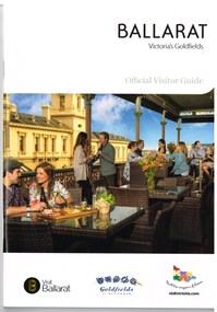 Ballarat Tramway Museum
Book, The Ballarat Visitor Information Centre, "Ballarat Victoria's goldfields Official Visitor Guide", 2015
Full colour, 84 page, book, A5 size titled "Ballarat Victoria's goldfields Official Visitor Guide", with a photo of a people eating on the verandah of the hotel opposite the old post office. Gives details, maps accommodation listing, attractions etc of the Ballarat area. Page 14 detail the Ballarat Tramway Museum. Inside rear cover is a fold out map of the district, city centre, Buninyong and Mt Helen and Ballarat and Surrounds. Published 2015 by The Ballarat Visitor Information Centre. trams, tramways, ballarat, visitors, tourist guides, btm, gardens