Showing 527 items
matching panoramas
-
 Clunes Museum
Photograph - PHOTOGRAPHY, PUBLISHED BY E. BARNETT, SNAPSHOTS OF CLUNES
THE PHOTOGRAPHS ARE; SOLDIERS MONUMENT, PORT PHILIP GOLD MINE, TULAROOP CREEK, TOWN HALL, PANORAMA, QUEEN'S WALK, BRIDGE, POST OFFICE,&TOWN HALL,STATE SCHOOL.9 FOLD OUT SNAP SHOTS OF CLUNES, PRESENTED IN FOLDERlocal history, photography, photographs, clunes township -
 Greensborough Historical Society
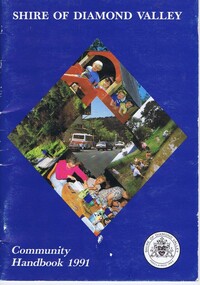
Book, Shire of Diamond Valley Community Handbook 1991, 1991_
Guide to services provided by Shire of Diamond Valley. The Shire of Diamond Valley was a Local Government Area located about 20 kilometres northeast of Melbourne. The shire covered an area of 74.38 square kilometres and existed from 1964 until 1994.Annual guide to services in Shire of Diamond Valley36 pages, col illus., maps. Front cover is a collage of scenes from Diamond Valley, back cover illustration of a copy of "Summer Panorama, Tabletop, NSW" by Max Dimmack, from the Shire of Diamond Valley Art Collection.shire of diamond valley, greensborough, handbooks -
 Greensborough Historical Society
Book, Shire of Diamond Valley, Shire of Diamond Valley Community Handbook 1991, 1991_
Guide to services provided by Shire of Diamond Valley. The Shire of Diamond Valley was a Local Government Area located about 20 kilometres northeast of Melbourne. The shire covered an area of 74.38 square kilometres and existed from 1964 until 1994.Annual guide to services in Shire of Diamond Valley36 pages, col. illus., maps. Front cover is a collage of scenes from Diamond Valley, back cover illustration of a copy of "Summer Panorama, Tabletop, NSW" by Max Dimmack, from the Shire of Diamond Valley Art Collection.shire of diamond valley -
Port Melbourne Historical & Preservation Society
Photograph - Beach Street, Port Melbourne, Alison Kelly, c. 1990
One of four photographs of Beach Street from Station to Princes Pier taken by Alison Kelly from the roof of the Missions to Seamen building. The four make up a panoramic view of the foreshore, .07 being an outer section of the panoramapiers and wharves - princes pier, alison kelly -
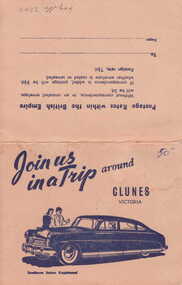 Clunes Museum
Photograph
PICTURESQUE SOUVENIR OF CLUNES. A FOLDER OF 8 PHOTOS CONSISTING OF VIEWS OF CLUNES 1. 4 PANORAMAS 2. CLUNES HOSPITAL 3. OLD POST OFFICE 4. TALLAROOP RIVER CLUNES 5. 2 OF FRASER STREET, CLUNESJOIN US IN A TRIP AROUND CLUNESlocal history, photography, photographs, township & buildings -
Port Melbourne Historical & Preservation Society
Magazine - Periodical, Port of Melbourne Panorama, 1988 - 1991
Six (6) copies of Port of Melbourne Panorama 1988-91 .01 - April 1988; .02 June 1988 ; .03 December 1988 ; .04 April/May 1989; .05 August/September 1989; .06 Third quarter 1991transport - shipping, maritime, melbourne harbor trust - port of melbourne authority -
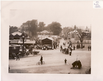
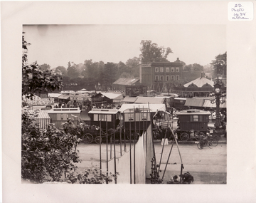 Whitehorse Historical Society Inc.
Photograph, Mitcham, Surrey England, 1900
Black and white photo of Mitcham Fair on Fair Green by Thos. Francis, London House, Mitcham, England. 1900. The photo overlaps and give a panorama of the Fair as far as could been seen from Ravensbury House (J.D.Drewett). See NP1438mitcham, england -
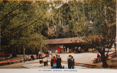 Ballarat Heritage Services
Souvenir - Postcard Booklet Image, Nucolor Vue, A Souvenir of Beautiful Daylesford, c1948
Daylesford in a tourist town with natural mineral water springsA booklet of colour images depicting 12 scenes of Daylesford, Victoria. The front cover is decorated with an illustration of a dirt road with sign post. Images include: Panorama over Daylesford, from lookout tower Panorama over Lake Daylesford Pioneer Memorial Lookout Tower, Daylesford Near the swimming pool, Lake Daylesford Botanical Gardens, Daylesford Vincent Street, showing Town Hall, Daylesford Vincent Street, Daylesford Glimpse of lovely Jubilee Lake, Daylesford Central Springs, Daylesford Sutton Springs, Daylesford Corner of the beautiful Botanical Gardens, Daylesford Loddon Falls, near Daylesford.daylesford, jubillee lake, wombat hill, vincent street, sutton springs, central springs, loddon springs, pioneer lookout, pioneer memorial lookout, loddon falls, lake daylesford -
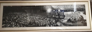 Vision Australia
Photograph - Image, Carols by Candlelight audience, crew and stage
Framed black and white panorama photograph of the crowd and stage at Carols by Candlelight. A choir master conducts a large choir, whilst the audience listen appreciatively and television cameras capture the event from platforms above the audience4 B/W photographs aligned to create panaromacarols by candlelight, marketing -
Clunes Museum
Newspaper - NEWSPAPER /CUTTING, 1933
IT SHOWS THE FOUNTAIN IN THE GARDEN, SHIRE HALL, MAIN STREET FROM THE WEST, THE SHOPPING CENTRE, THE STATE SCHOOL PANORAMA, THE STATE SCHOOL SCHOLARS. A CORNER OF THE TOWN. WAR MEMORIAL, GOLD DISCOVERY MONUMENT. E.SA BANK & A PRETTY STRETCH OF THE CREEK, KNITTING MILL.local history, document, newspaper cutting, weickhardt family -
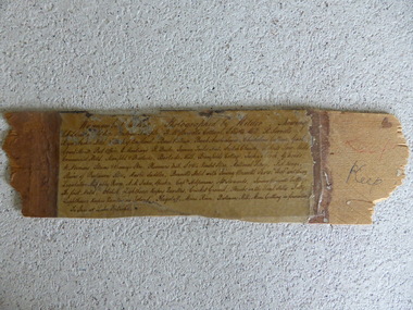 Warrnambool and District Historical Society Inc.
Frame Fragment, Frame Fragment from 1860 J Wilder, Late 19th century
Joseph Wilder, a professional photographer, came to Warrnambool in 1860 and took a series of photographs, two of which survive today. One was of the local Volunteer Corps and the other was a series of photographs taken from Cannon Hill showing Merri Street and the town and buildings beyond. It seems that copies of these last-mentioned photographs were framed to produce a large panoramic view of 1860 Warrnambool and one of these was given to the old Warrnambool Museum in the 1880s by James Astley Bromfield. He had established a chemist’s shop in Warrnambool in 1854 and showed his interest in the history of the young town by producing a map in 1856 showing the first landowners, a seminal resource today for historians. He again demonstrated this interest when he included the names of the people and places in the 1860 photograph he gave to the museum in the 1880s. The frame fragment was found amongst the collection of items from the old Museum at Flagstaff Hill Maritime Museum and brought to the Historical Society to accompany the original series of photographs. Bromfield went to live in Melbourne in the 1880s. It is presumed that the plastic cover has been placed on the frame fragment at a much later date than the 1880s.This frame fragment is interesting and very important for several reasons:- 1. It is one demonstration of the interest that James Astley Bromfield had in local history 2. It came from the old Warrnambool Museum and shows how that institution kept items of historical interest 3. It gives us the names of the people and places in the Joseph Wilder photographs of 1860 that placed together form a panorama that reveals what a major section of Warrnambool looked like only 13 years after its foundation. The list enables us to correctly identify the early places and people and so is invaluable for research purposes 4. It links a Museum exhibit of the 1880s with the original 1860 photographs which are held by the Historical Society This is a piece of wood broken from a frame containing a photograph. It has jagged edges. It contains the list of people and places depicted in the Joseph Wilder panorama photograph of Warrnambool in 1860. The list is handwritten in ink on paper which has been attached to the frame with a piece of plastic. Warrnambool in 1860 Photographed by Wilder. Showing children of the late Andrew Semple etc In red pencil – ‘Keep’, in ink, ‘Keep’ On separate piece of paper - Presented to Warrnambool Mechanics’ Muzeum by James Astley Bromfield, August 3rd 1886 joseph wilder 1860, panorama of warrnambool -
 Whitehorse Historical Society Inc.
Photograph, Mitcham, England, 1900
Black and white photo of Black and white photo of Mitcham Fair on Fair Green by Thos. Francis, London House, Mitcham, England. 1900. The photo overlaps and give a panorama of the Fair as far as could been seen from Ravensbury House (J.D.Drewett). See NP1437mitcham, surrey, england -
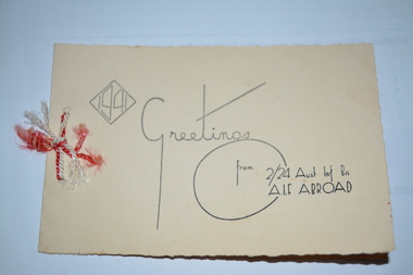 Wangaratta RSL Sub Branch
Card, c1941
1941 Christmas Greeting card produced for the 2/24 Infantry Battalion AIF whilst abroad to send to family and loved ones.Folded cream cardboard with irregular edging and wording in black print on front cover and inside back cover. Red and white rolled thread/ribbon tied through two punched holes on left margin. Inside contains a black and white panorama of a seaside bay. 1941 Greetings from 2/24 Aust Inf Bn/AIF ABROAD Inside card - Wishing you a Very Merry Christmas and Joy in the New Year/Xmas 1941/New Year 19422/24 bn, ww2 -
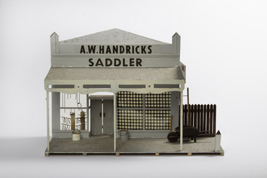 Port Fairy Historical Society Museum and Archives
Decorative object - Model, A W Handricks Saddler, early 1970`s
This model was part of eleven pieces designed from an almanac in 1892 printed by the Port Fairy Gazette. The panorama was used in the historical Society rooms in Bank Street on an extended mantle piece, before the Museum and Archives relocated to Gipps StreetThis model was made as a part of an eleven piece model of the streetsccape of Port Fairy in 1892. By a local resident of the town.Small hand made model of a shop front from the 1892 almanacA.W. Handricks Saddlerpanorama, model, mewkill, almanac, bank street -
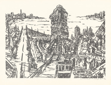 Latrobe Regional Gallery
Print, SENBERGS, Jan b.1939 Riga, Latvia. Arrived Australia 1950, Port Panorama, 1980
LithographTitled and signed 'Port Panorama - J. Senbergs. '80.' lower right under printed image. Edition 19/20, lower right corner under printed image. -
Port Melbourne Historical & Preservation Society
Photograph - Various reserves, Port Melbourne, Ron Laing, 1986 - 1999
Part of Ron Laing's collection of photographs recording Port Melbourne over a thirteen year period. Donated to the PMH&PS by the photographer.A set of 42 colour photographs of the various reserves including Garden City Reserve, West Gate Park and ibis, Boulevard and site from Webb Dock, new Evans Street gardens on the old railway sidings, and panorama looking east from Webb Dock. 1990sbuilt environment, natural environment, parks and gardens, ron laing -
Port Melbourne Historical & Preservation Society
Photograph - PMHPS display, Station Pier, Port Melbourne, Ann Smallpage, 21 May 2006
Taken by Ann SMALLPAGE, who walked the length of the festival and back - Sandridge Beach to Station PierFrom a set of photographs taken by Ann SMALLPAGE showing the PMH&PS display at Station Pier on Sunday 21 May 2006 for a festival celebrating the completion of Beacon Cove . Shows visitors examining display board of Alison KELLY's 1990 panoramas. Maree CHALMERS is explaning.Numbered (4) and dated on back by donor.celebrations fetes and exhibitions, beacon cove, port melbourne historical & preservation society, pmhps, maree chalmers -
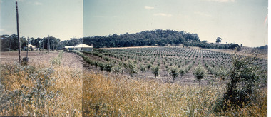 Southern Sherbrooke Historical Society Inc.
Photograph - Photo-colour- Montague apple orchard, 1954
Colour photograph of Bill and Stella Montague's original house with the orchard that was planted in 1952 in the foreground. The home of Alf and Marion Montague (Bill's parents) is on the left. A line on the left side indicates this is two photos stuck together to form a panorama. Trees in orchard appear to be quite young. -
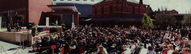 Federation University Historical Collection
Photograph - Colour, Steve Bracks, Premier of Victoria, opens the University of Ballarat Arts Academy, Camp Street, 22/07/2008
The University of Ballarat inherited the Camp Street Arts Precinct. As the functions of the former public buildings were moved elsewhere, the Victorian Government of the time recognised the importance of maintaining the heritage buildings and the opportunity to create a cultural precinct extending from the Art Gallery. The 19th century architecture along Lydiard Street and the dogleg bend of Camp Street define the precinct. With substantial financial assistance from both State and Commonwealth Governments, the Art Gallery Ballarat has been extended through to include the 1884 Police Station on Camp Street. The Post Office building (1864-1887) was acquired for the University. The 1904 and 1941 Courthouses and the c1900 Public Library building were also included. Two new buildings have been constructed. These six buildings will house the University's Visual and Performing Arts Programs.3 Panorama photograph of the opening of the University of Ballarat Arts Academy, Camp Street. .2 Poster .1) L to R Kerry Cox (Vice Chancellor); Brendan Nelson (Federal Minister - Education); Chancellor David Caro; Steve Bracks, Premier of Victoria. Photographer Ian Reiduniversity of ballarat, camp street, victorian government, commonwealth government, ballarat fine art gallery, police station, courthouse, public library, post office, art gallery ballarat -
 Bendigo Historical Society Inc.
Photograph - DAWN SMITH COLLECTION: PHOTOS OF BENDIGO, 1934
Dawn Smith Collection. Black & White Photograph Panorama of Bendigo taken from the poppet head in Rosalind Park. Williamson Street running north up the centre, Shamrock Hotel, R.S.L. & Law Courts visible. Tourism Souvenir Photograph Set. ?Rose Collection Series. 1934.bendigo, tourism, bendigo poppet head rosalind park -
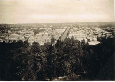
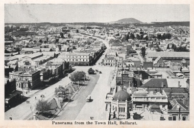 Ballarat Tramway Museum
Photograph - Illustration, "Panorama from the Town Hall", c1907
Set of two views from an illustrated publication on Ballarat. 1 - "Panorama from the Town Hall" - with three ESCo trams in the view, though very few pedestrians or other vehicles. High lights Mount Warrenheip. 2 - A view of Lake Wendouree - Fairyland.Yields information about Sturt St from the Town Hall towards Mt Warrenheip.Illustration cut from a magazine or publicationballarat, illustrations, sturt st, lydiard st, esco, mount warrenheip, lake wendouree -
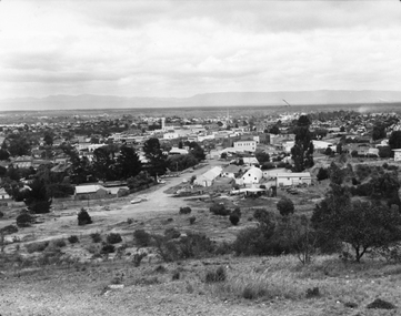 Stawell Historical Society Inc
Photograph, Panorama of Stawell from Big Hill c 1960's
Panorama View of Stawell from Big Hill with Grampians in Background. c 1960 looking Down top end of Sloane Street across Fisher Street. Stawell Court House visible. Top end of Main Street Visible corner of Patrick and Main StreetBlack & White photo of Stawell from Big Hill. View showing Upper Sloan St with Fisher St crossing to the right. stawell, panorama, streetscape -
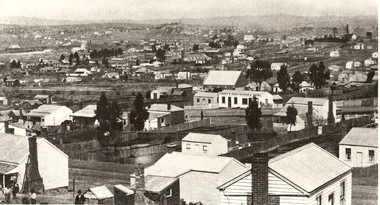 Bendigo Historical Society Inc.
Photograph - NEW CHUM GULLY C 1875, C 1875
Back and white photograph: panorama showing timber and brick residences, hotel, church ? Mines with poppet heads and chimneys in background. An image on building at centre ' Cleary's Honeysuckle Hotel' Ken Arnold captions this image ' New Chum Gully from Specimen Hill C 1875, photographer Caire 'Caireplace, landscape view, new chum gully, bendigo, cityscape, sandhurst, panorama, mining town -
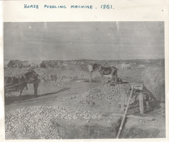 Bendigo Historical Society Inc.
Photograph - HORSE PUDDLING MACHINE VICTORIA HILL?, c.1861
Black and white panorama with mine workings (puddling machine and two horses and two workers) with scattered (residential?) buildings in open rough background. Inscriptions: on front - 'horse puddling machine 1861' hand printed across top. On back - 'Gold Mines Bendigo 1861, this could be Victoria Hill'.place, mining site, victoria hill ? -
 Bendigo Historical Society Inc.
Postcard - BENDIGO - FOLD-OUT VIEW
Fold-out views of Bendigo, including a panorama from the lookout tower, Bendigo Pottery, Pall Mall, Conservatory Gardens, Poppet head Central Deborah, Cenotaph, Joss House, Alexandra Fountain, interior Chinese Joss House, Sun Loong, Easter Parade. Appears to be 1970's ?bendigo, streetscape, bendigo, postcards. -
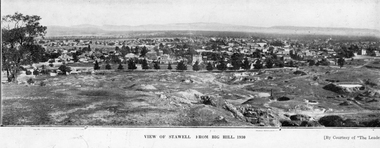 Stawell Historical Society Inc
Photograph, Panorama of Stawell from Big Hill c 1930
Panorama of Stawell from Big Hill, Looking at Patrick Street. Grampians in Background Views from Big Hill 1930 showing remnants of mining. Visible Kinsella House Patrick Street, Stawell Court House, Hotel Patrick Street, Upper end of Main StreetTwo identical paper print views of Stawell from Big Hill, taken in 1930 courtesy of "The Leader". View of Stawell From Big Hill 1930 [By Courtesy of "The Leader'stawell, panorama, mining, streetscape -
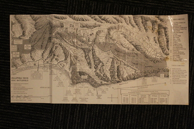 Lara RSL Sub Branch
Group of Maps World War One, Group of Maps World War One - Dardanelles and Anzac Gallipoli Maps Circ 1915, Circ 1916
Gallipoli 1915 Maps and Naval plan of Operations World War One ANZACRare examples that explain both ANZAC and Naval Operations during World War One Gallipoli & Dardanelles Passage .!. Black and White Photocopy of Gallipoli 1915 ANZAC Battlefield - detailed positions of troops and Cemeteries. 2.The Allied Failure to Force The Dardanelles Passage 18 March 1915 - detailed line of Attack Naval Organisation, Mine layout, Plan of Attack (and copy).. 3. Map of Turkey and surrounding area written in Turkish and German Languages. C0olor version main roads and distances. (and copy).. 4. Map of ANZAC Trench Diagram. World War One.Color. (and copy). 5.Panorama of Chunuk Blair from 3 miles south of Nibrunesi Point, 3 November 1915 and Anzac from 1 mile N. E. of Ari Burnu, 21 November 1915. Black & White 6. Color Map of ANZAC positions with topographical Details, notes. 1. Artwork and copyright by Srewart Cownie, Gallipoli 1915 ANZAC Battlefield with Landings and later evacuation marked. 2. Details of Naval actions taken in the Dardanelles Passage 18 March 1918. 3. Local area Map or Turkey. Shows roads network and townships. 4. ANZAC Trench Diagram, copyright Whitcombe & Tombs Limited , Wellington N.Z. 1919 5. Panorama of two coast views of ANZAC area. Australian War Memorial, 6. Map of ANZAC positions of World War One, Gallipoli 1915. Published by H.E.C. Roberinson, George Street, Sydney N.S.W.18 April 1916maps operational of anzac and naval opations during 1915 etc, dardanelles naval opations -
Port Melbourne Historical & Preservation Society
Photograph - J Kitchen & Sons perimeter survey, from North Port Oval, Dec 2013
As the former j Kitchen & Sons site was being cleared, Lionel Layfield, who had worked at the site for many years undertook several pictorial perimeter surveys. These photos were taken in Dec 2013.Series 1 of colour photographs taken by Lionel Layfield as he walked around the perimeter of the J Kitchen & Sons Pty Ltd factory site during the early demolition of most of the buildings. .55-.60 - panorama looking towards Kitchens (city views behind) from Port Melbourne football groundindustry - manufacturing, built environment - industrial, business and traders - soaps/candles, j kitchen & sons pty ltd, symex holdings ltd, north port oval, port melbourne cricket and football oval -
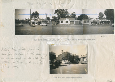 Eltham District Historical Society Inc
Document - Photograph, Ian McDonald (Shire of Eltham), Main Road, between Arthur Street and Dudley Street, Eltham, 1968-1970
Original document produced by Ian McDonald (Eltham Shire Council) 1970. During the period 1969-1971 photos were being collected for a proposed publication on the history of the Shire of Eltham as part of its centenary celebrations in 1971 (managed by the Shire of Eltham Historical Society and Alan Marshall). The publication was Pioneers & Painters (1971), edited by Alan Marshall. The document titled "Shows area sold to Woolworths" consisted of a panorama of three B&W photo prints creating a panorama of the frontage along Main Road (SEPP_0744) and a single B&W photo print of the Shire of Eltham offices and Hall on the corner of Arthur Street and Main Road (SEPP_0737) along with typed and hand written notes by Ian McDonald. The panorama (SEPP_0744) was captioned in typewritten text "Old Shire Office and Hall, etc - Frontage of 285 feet along Main Road" and in pencil the date "4-1-68" The single image of the shire offices (SEPP_0737) was captioned in typewritten text "Main Road and Arthur Street Corner" In addition, the following handwritten notes in pencil: " I took these photos from the new fire station - the building in the middle is the old fire station - Moved to Research for the Scouts 1970" and signed "IMcD"This photo forms part of a collection of photographs gathered by the Shire of Eltham for their centenary project book,"Pioneers and Painters: 100 years of the Shire of Eltham" by Alan Marshall (1971). The collection of over 500 images is held in partnership between Eltham District Historical Society and Yarra Plenty Regional Library (Eltham Library) and is now formally known as the 'The Shire of Eltham Pioneers Photograph Collection.' It is significant in being the first community sourced collection representing the places and people of the Shire's first one hundred years.Paper with four photos adhered in two groups with notes in typewritten text and handwritten in pencilsepp, shire of eltham pioneers photograph collection, eltham, main road, arthur street, dudley street, barber shop, cinema, commercial bank of australia, eltham fire brigade, eltham hall, eltham shire hall, eltham shire office, fire station, hardware shop, municipal offices, photographer shop, pph, produce paint and hardware centre, shire hall, shire offices, woolworths -
Clunes Museum
Card
A THANK YOU CARD WITH ROSES ON THE FRONT THE CARD WAS SENT FROM KAROLINA TO MERLE ALEXANDER ,( FORMER TEAM LEADER OF THE WAREHOUSE CLUNES) AT THE COMPLETION OF KAROLINA'S ART EXHIBITION AT THE WAREHOUSEDEAR MERLE AND STAFF, ON COMPLETION OF MY EXHIBITION "PANORAMA, PETALS & PLACES" I WOULD LIKE TO EXTEND MY THANKS AND GRATITUDE TO ALL WHO SUPPORTED MY VENTURE. WARMEST REGARDS KAROLINAkarolina, merle alexander