Showing 836 items
matching parish map
-
 Bendigo Historical Society Inc.
Map - EPPALOCK, 3/07/1890
... Map: Parish of Eppalock. County of Bendigo. Parish plan... Bendigo parish plan Eppalock Map: Parish of Eppalock. County ...Map: Parish of Eppalock. County of Bendigo. Parish plan (number 338 in map cupboard 1)map, bendigo, parish plan, eppalock -
Bendigo Historical Society Inc.
Map - LYELL, 24/09/1907
... Map: Parish of Lyell, County of Bendigo. Parish plan... Bendigo parish plan Lyell Map: Parish of Lyell, County of Bendigo ...Map: Parish of Lyell, County of Bendigo. Parish plan (number 337 in map cupboard 1)map, bendigo, parish plan, lyell -
Bendigo Historical Society Inc.
Map - EGERTON, 28/01/1896
... Map: Parish of Egerton, County of Bendigo. Parish plan... Bendigo parish plan Egerton Map: Parish of Egerton, County ...Map: Parish of Egerton, County of Bendigo. Parish plan. (number 335 in map cupboard 1)map, bendigo, parish plan, egerton -
Bendigo Historical Society Inc.
Map - BALLENDELLA, 12/06/1882
... Map: Parish of Ballendella, County of Bendigo. Parish plan... Bendigo parish plan Ballendella Map: Parish of Ballendella, County ...Map: Parish of Ballendella, County of Bendigo. Parish plan (number 333 in map cupboard 1)map, bendigo, parish plan, ballendella -
Bendigo Historical Society Inc.
Map - MARONG, 16/08/1881
... Map: Parish of Marong, County of Bendigo. Parish plan... Bendigo parish plan Marong Map: Parish of Marong, County ...Map: Parish of Marong, County of Bendigo. Parish plan (number 328 in map cupboard 1)map, bendigo, parish plan, marong -
Bendigo Historical Society Inc.
Map - EPPALOCK, 3/11/1882
... Map: Parish of Eppalock, County of Bendigo. Parish plan... Bendigo parish plan Eppalock Map: Parish of Eppalock, County ...Map: Parish of Eppalock, County of Bendigo. Parish plan (number 327 in map cupboard 1)map, bendigo, parish plan, eppalock -
Bendigo Historical Society Inc.
Map - DARGILE, 14/10/1906
... Map: Parish of Dargile, County of Rodney. Parish plan... Rodney parish plan Dargile Map: Parish of Dargile, County ...Map: Parish of Dargile, County of Rodney. Parish plan (number 324 in map cupboard 1)map, rodney, parish plan, dargile -
Bendigo Historical Society Inc.
Map - WELLSFORD, 15/10/1903
... Map: Parish of Wellsford, County of Bendigo. Parish plan... Bendigo parish plan Wellsford Map: Parish of Wellsford, County ...Map: Parish of Wellsford, County of Bendigo. Parish plan (number 321 in map cupboard 1)map, bendigo, parish plan, wellsford -
Bendigo Historical Society Inc.
Map - HEATHCOTE, 11/04/1935
... Map: Parish of Heathcote, County of Dalhousie. Parish plan... Dalhousie parish plan Heathcote Map: Parish of Heathcote, County ...Map: Parish of Heathcote, County of Dalhousie. Parish plan (number 320 in map cupboard 1)map, dalhousie, parish plan, heathcote -
Bendigo Historical Society Inc.
Map - TALAMBE, 26/11/1880
... Map: Parish of Talambe, County of Bendigo. Parish plan... Bendigo parish plan Talambe Map: Parish of Talambe, County ...Map: Parish of Talambe, County of Bendigo. Parish plan (number 315 in map cupboard 1)map, bendigo, parish plan, talambe -
Bendigo Historical Society Inc.
Map - PANNOOBAMAWM, 6/11/1882
... Map: Parish of Pannoobamawm, County of Bendigo, Parish plan... Bendigo parish plan Pannoobamawm Map: Parish of Pannoobamawm ...Map: Parish of Pannoobamawm, County of Bendigo, Parish plan (number 314 in map cupboard 1)map, bendigo, parish plan, pannoobamawm -
Bendigo Historical Society Inc.
Map - PANNOOBAMAWM, 7/12/1914
... Map: Parish of Pannoobamawm, County of Bendigo. Parish plan... Bendigo parish plan Pannoobamawm Map: Parish of Pannoobamawm ...Map: Parish of Pannoobamawm, County of Bendigo. Parish plan (number 313 in map cupboard 1)map, bendigo, parish plan, pannoobamawm -
Bendigo Historical Society Inc.
Map - SEDGWICK, 5/04/1881
... Map: Parish of Sedgwick, County of Bendigo. Parish plan... Bendigo parish plan Sedgwick Map: Parish of Sedgwick, County ...Map: Parish of Sedgwick, County of Bendigo. Parish plan (number 312 in map cupboard 1)map, bendigo, parish plan, sedgwick -
Bendigo Historical Society Inc.
Map - WELLSFORD, 4/07/1876
... Map: Parish of Wellsford, County of Bendigo... Bendigo parish plan Wellsford Map: Parish of Wellsford, County ...Map: Parish of Wellsford, County of Bendigo. Strathfieldsaye, Wellsford , Bagshot (number 311 in map cupboard 1)map, bendigo, parish plan, wellsford -
Bendigo Historical Society Inc.
Map - KAMAROOKA ALLOTMENTS, 7/06/1894
... Map: Parish of Kamarooka Allotments, County of Bendigo... Bendigo allotments Kamarooka Allotments Map: Parish of Kamarooka ...Map: Parish of Kamarooka Allotments, County of Bendigo. Parish plan (number 288 in map cupboard 1)map, bendigo, allotments, kamarooka, allotments -
Bendigo Historical Society Inc.
Map - BAGSHOT, Circa 1878
... Map: Parish of Bagshot, County of Bendigo. Parish plan... Bendigo parish plan Bagshot Map: Parish of Bagshot, County ...Map: Parish of Bagshot, County of Bendigo. Parish plan (coloured) (number 329 in map cupboard 1)map, bendigo, parish plan, bagshot -
Bendigo Historical Society Inc.
Map - GOORNONG, 29/04/1879
... Map: Parish of Goornong, County of Bendigo. Parish plan... Bendigo parish plan Goornong Map: Parish of Goornong, County ...Map: Parish of Goornong, County of Bendigo. Parish plan (coloured) (number 326 in map cupboard 1)map, bendigo, parish plan, goornong -
 Bendigo Historical Society Inc.
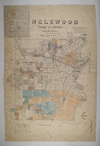
Map - INGLEWOOD, 17/12/1877
... Map: Parish of Inglewood, County of Gladstone. Parish plan...MAP Gladstone parish plan Inglewood Map: Parish ...Map: Parish of Inglewood, County of Gladstone. Parish plan. Earliest date on map 31/12/75.map, gladstone, parish plan, inglewood -
 Ringwood and District Historical Society
Map, Plan of the Parish of Warrandyte County of Evelyn - 1841
... (Warrandyte) and Mullum Mullum Creek (Ringwood). List of Parish map...) and Mullum Mullum Creek (Ringwood). List of Parish map references ...Blueprint copy of Survey Map W27 detailing original Selectors' names and property locations between Yarra Yarra River (Warrandyte) and Mullum Mullum Creek (Ringwood). List of Parish map references including property bearings, distances in Links, and markings on trees. Pound Bend area of Warrandyte marked as Reserve For Aborigines. Descriptive remarks include areas marked "scrubby, flat, sandy soil". Several other references faded and illegible.(Map) by T.H. Nutt Feb 3 1841. -
Clunes Museum
Photograph - PHOTOGRAPHS AND DOCUMENTS
... of James Goldsworthy Scholl 4. Copy of parish map showing school... of parish map showing school location 5. Written account of family ...James Goldsworthy Scholl had a private school in Clunes in early 1870's. He was born in Cornwall, U.K. in 1836 and married Emily Bennett in February 1857. James arrived in Melbourne on the "Agincourt" in November 1863 and Emily in July 1863 on the "Golden Land" James died in 1893 and Emily 19321. Enlarged photo of Mrs. James Goldsworthy Sholl (nee Bennett) Approx 1879 with 5 of 11 children (from left to right Albert 1875, Laura 1864, Emily Scholl, Bertha 1877, Arthur 1870, Anne 1868) 2. Original photo of Emily Scholl 3. Original photo of James Goldsworthy Scholl 4. Copy of parish map showing school location 5. Written account of family historyOn item 2. and 3. Printed gold lettering Yeoman, Paris Panel, Royal Arcade Melbournescholl, goldsworthy, private school, education -
Bendigo Historical Society Inc.
Map - NERRING, 15/06/1937
... Map: Parish of Nerring, County of Bendigo. Parish plan... Bendigo rural Nerring County of Bendigo Map: Parish of Nerring ...Map: Parish of Nerring, County of Bendigo. Parish plan Canvas backed ( number 139 in Map Cupboard 1)map, bendigo, rural, nerring, county of bendigo -
Bendigo Historical Society Inc.
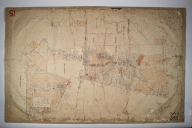
Map - PARISH OF SANDHURST SHEET 5A, 1970
... Map: Parish of Sandhurst Sheet 5A, County of Bendigo... Bendigo parish plan parish of Sandhurst County of Bendigo Map ...Map: Parish of Sandhurst Sheet 5A, County of Bendigo. Parish plan ( number 161 in Map Cupboard 1)map, bendigo, parish plan, parish of sandhurst, county of bendigo -
Bendigo Historical Society Inc.
Map - EAGLEHAWK (PART), 22/01/1882
... Map: Parish plan showing area Eastward from Lightning Hill... Bendigo parish plan Eaglehawk Lightning Hill Map: Parish plan ...Map: Parish plan showing area Eastward from Lightning Hill ( number 205 in Map Cupboard 1)map, bendigo, parish plan, eaglehawk, lightning hill -
Bendigo Historical Society Inc.
Map - SANDHURST (PART), Circa 1880's
... Map: Parish plan sowing an area along Specimen Hill Rd... Bendigo parish plan Specimen Hill Rd. Sandhurst Bendigo Map ...Map: Parish plan sowing an area along Specimen Hill Rd. ( number 211 in Map Cupboard 1)map, bendigo, parish plan, specimen hill rd. sandhurst , bendigo -
Bendigo Historical Society Inc.
Map - PARISH OF MARONG ALLOTMENTS, No date Visible
... Map: Parish of Marong Allotments, County of Bendigo. Parish... Bendigo allotments Marong Allotments Map: Parish of Marong ...Map: Parish of Marong Allotments, County of Bendigo. Parish plan Blueprint (number 286 in map cupboard 1)map, bendigo, allotments, marong allotments -
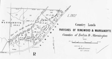 Ringwood and District Historical Society
Photograph, Early map of parishes of Ringwood and Warrandyte in Counties of Evelyn and Mornington - c.1868, 1868
... Copy of an early map of parishes of Ringwood and Warrandyte.... Vol. 5, Fol.13/1224". Copy of an early map of parishes ...Copy of an early map of parishes of Ringwood and Warrandyte, Counties if Evelyn and MorningtonWritten on backing sheet, "c1868. Vol. 5, Fol.13/1224". -
Bendigo Historical Society Inc.
Map - LYELL, 4/06/1873
... Map: Lyell. Parish plan (number 278 in map cupboard 1)... Bendigo parish plan Lyell Map: Lyell. Parish plan (number 278 ...Map: Lyell. Parish plan (number 278 in map cupboard 1)map, bendigo, parish plan, lyell -
Bendigo Historical Society Inc.
Map - PARISH OF EPPALOCK RESURVEY, 23/05/1876
... Map: Parish of Eppalock resurvey, County of Bendigo, hand... Bendigo parish plan Eppalock resurvey Map: Parish of Eppalock ...Map: Parish of Eppalock resurvey, County of Bendigo, hand draughted Parish plan ( number 240 in Map Cupboard 1)map, bendigo, parish plan, eppalock, resurvey -
Bendigo Historical Society Inc.
Map - SANDHURST (PART), Circa 1880's
... Map: Parish plan showing the area Specimen Hill Road... Bendigo parish plan Specimen Hill Rd. Inglewood St. Map: Parish ...Map: Parish plan showing the area Specimen Hill Road and Inglewood St. ( number 222 in Map Cupboard 1)map, bendigo, parish plan, specimen hill rd. inglewood st. -
 Bendigo Historical Society Inc.
Map - EPSOM ?, Circa 1880
... Map: Parish plan showing an area Southwards from the parish...MAP Bendigo parish plan Epsom Ascot White Hills Map: Parish ...Map: Parish plan showing an area Southwards from the parish of Huntly boundary, Covering Epsom,Ascot and White Hillsmap, bendigo, parish plan, epsom, ascot, white hills