Showing 2288 items matching "parishes"
-
 Bendigo Historical Society Inc.
Map - PANNOOBAMAWM, 7/12/1914
Map: Parish of Pannoobamawm, County of Bendigo. Parish plan (number 313 in map cupboard 1)map, bendigo, parish plan, pannoobamawm -
Bendigo Historical Society Inc.
Map - SEDGWICK, 5/04/1881
Map: Parish of Sedgwick, County of Bendigo. Parish plan (number 312 in map cupboard 1)map, bendigo, parish plan, sedgwick -
 Bendigo Historical Society Inc.
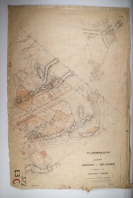
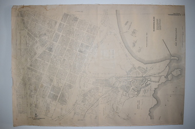
Map - BOROUGH OF EAGLEHAWK RE-SURVEY, 6/06/1883
Map: Re-survey, Borough of Eaglhawk, Parishes of Nerring and Sandhurst, Sheet No. 1. Parish planmap, bendigo, re-survey, borough of eaglehawk, re-survey -
 Bendigo Historical Society Inc.
Map - MARONG, 21/01/1916
Map: Parish of Marong, County of Bendigo. Parish plan. Map dated 21/01/1916map, bendigo, parish plan, marong -
 Bendigo Historical Society Inc.
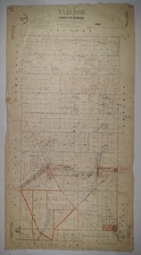
Map - YALLOOK, 25/02/1876
Map: Parish of Yallook, County of Bendigo. Parish plan. Map dated 25/02/1876.map, bendigo, parish plan, yallook -
 Bendigo Historical Society Inc.
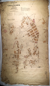
Map - PART OF THE BOROUGH OF EAGLEHAWK, 9/12/1902
Map: Part of the Borough of Eaglehawk, Parish of Sandhurst, County of Bendigo. Parish plan Canvas backed.map, bendigo, city streets, borough of eaglehawk, parish of sandhurst, county of bendigo -
Whitehorse Historical Society Inc.
Document, Certificate of Title, 1928, 1933-1934
Certificate of Title, Nanny Schifferdecker.Certificate of Title, Nanny Schifferdecker. Lots 44, 45,56 & 57 subdivision 3360 Crown portion 97 Parish of Nunawading, County of Bourke 1928. Vol 5406 fol 10881070 1928, Agnew and Craig Streets. Also correspondence re rates enforcement charge 1933.Certificate of Title, Nanny Schifferdecker. land titles, shire of blackburn and mitcham, schifferdecker, hanny, craig street, blackburn south, agnew street, blackburn south -
 Warrnambool and District Historical Society Inc.
Documents Maps (3) - Warrnambool Town Allotments, City of W'bool Parish of Wangoom Country of Villiers, 1948
These maps were produced in 1948 and they contain maps of allotments within the city of Warrnambool, including the Central Business District, up to 1948. The details given on each allotment show the allotment and section numbers, the measurement in acres, the name of the original purchaser of the lot and the date of the first sale. The Warrnambool and District Historical Society owns several copies of these maps but these ones are originals.These three maps are of great significance because they give the names of land purchasers in Warrnambool from the date of the first land sales in 1847. They are a most valuable research tool and can be scanned and photocopied etc.These are three sheets of cream paper pasted on to linen. The sheets have black and white printing and map work. Some of the edges are a little frayed and there is some staining, particularly on the backs of the sheets.‘City of Warrnambool Parish of Wangoom County of Villiers Sheet 1’ ‘City of Warrnambool Parish of Wangoom County of Villiers Sheet 2’ ‘City of Warrnambool Parish of Wangoom County of Villiers Sheet 3’city of warrnambool, warrnambool maps, warrnambool town allotments 1948, land purchases -
 Melton City Libraries
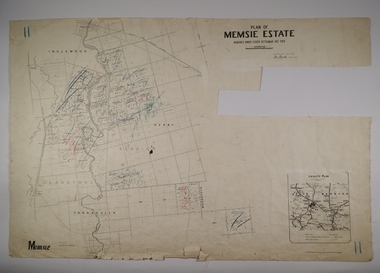
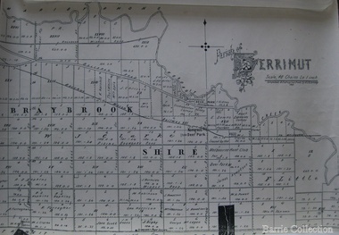
Map, Parish of Derrimut, 1931
Map of the Parish of Derrimutcouncil -
 Linton and District Historical Society Inc
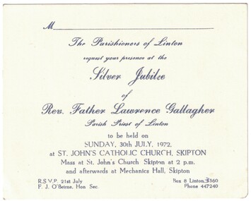
Invitation, Silver Jubilee, Rev. Father Lawrence Gallagher, 1972
White cardboard invitation with blue printed text. The invitation is to celebrate the silver jubilee of Rev. Father Lawrence Gallagher, Parish Priest of Linton, at St. John's Catholic Church, Skipton, Sunday, 30th July, 1972.Text: " The Parishioners of Linton / request your presence at the /Silver Jubilee / of / Rev. Father Lawrence Gallagher / Parish Priest of Linton / to be held on / SUNDAY, 30th JULY, 1972. / at ST. JOHN'S CATHOLIC CHURCH, SKIPTON / Mass at St. John's Church Skipton at 2 p.m. / and afterwards at Mechanics Hall, Skipton. "rev. father lawrence gallagher, st. john's catholic church skipton, silver jubilee -
 City of Moorabbin Historical Society (Operating the Box Cottage Museum)
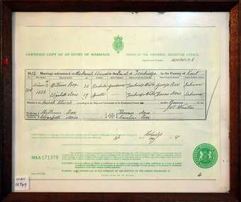
Document - Copy of Marriage Certificate William Box 1854, 14 May 1997
This copy of the Marriage Certificate of William and Elizabeth Avis-Box was obtained by CMHS member Dennis Maynard in May 1997. William Box and Elizabeth Avis Box came to Australia with his parents George and Mary Cripps-Box and siblings in 1856 William Box with his wife Elizabeth Avis Box and 13 children lived and farmed on the block of land in Jasper Road, East Brighton ( now McKinnon / Ormond) that was part of the Henry Dendy Special Survey 1841. Caroline Box, the eldest daughter of George and Mary Cripps-Box, remained in England working as a cook until she joined the family in Australia in 1863. William Box with his wife Elizabeth Avis Box and 13 children lived and farmed on the block of land in Jasper Road, East Brighton ( now McKinnon / Ormond) that was part of the Henry Dendy Special Survey 1841 Box Cottage Museum is the reconstructed pioneer cottage that William and Elizabeth lived in 1865 until they built a new house on the land. The Certified Copy of the Marriage Entry of William Box and Elizabeth Avis at the Parish Church, Tonbridge, Kent, England on November 13th 1854 in a wood frame with glass* CERTIFIED COPY OF AN ENTRY OF MARRIAGE / crest / GIVEN AT THE GENERAL REGISTER OFFICE / Application number C009059/0 / 1854 Marriage solemnised at The Parish Church of Tonbridge in the County of Kent / 206 / November 13th / 1854 / William Box 20 Bachelor Gardener / Elizabeth Avis 19 Spinster/ ………… Signed by William Box , Elizabeth Avis with Thomas Avis and Caroline Box as the Witnesses. Issued at Tonbridge 14th May 1997 MXA 171379 box william, box elizabeth avis, moorabbin, ormond, parish of tonbridge, farmers, dairy, market gardeners, pioneers, early settlers, kent, england, certificates, box caroline, avis thomas, -
Bendigo Historical Society Inc.
Map - RESURVEY, PARISH OF SANDHURST, 1/08/1891
Map: Resurvey , Parish of Sandhurst sheet 3. Parish plan ( number 203 in Map Cupboard 1)map, bendigo, parish plan, parish of sandhurst resurvey -
Bendigo Historical Society Inc.
Map - PARISHES OF WARRAGAMBA AND MINTO, No date visible
Map: Parishes of Warragamba and Minto,Hand draughted parish plan. (number 290 in map cupboard 1)map, parish plan, warragamba, minto -
Bendigo Historical Society Inc.
Map - KAMAROOKA ALLOTMENTS, 7/06/1894
Map: Parish of Kamarooka Allotments, County of Bendigo. Parish plan (number 288 in map cupboard 1)map, bendigo, allotments, kamarooka, allotments -
Bendigo Historical Society Inc.
Map - BAGSHOT, Circa 1878
Map: Parish of Bagshot, County of Bendigo. Parish plan (coloured) (number 329 in map cupboard 1)map, bendigo, parish plan, bagshot -
Bendigo Historical Society Inc.
Map - GOORNONG, 29/04/1879
Map: Parish of Goornong, County of Bendigo. Parish plan (coloured) (number 326 in map cupboard 1)map, bendigo, parish plan, goornong -
 Bendigo Historical Society Inc.
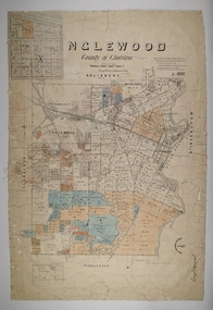
Map - INGLEWOOD, 17/12/1877
Map: Parish of Inglewood, County of Gladstone. Parish plan. Earliest date on map 31/12/75.map, gladstone, parish plan, inglewood -
 Marysville & District Historical Society
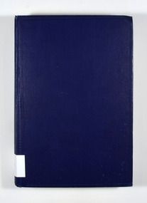
Book, Percy Dearmer, The Parson's Handbook, 1932
The Parson's Handbook contains practical directions both for parsons and others as to the management of the parish church and it's services according to the Anglican use, as set forth in the book of common prayer.Cover is navy blue with the title and author on the spine in gold lettering.non-fictionThe Parson's Handbook contains practical directions both for parsons and others as to the management of the parish church and it's services according to the Anglican use, as set forth in the book of common prayer.parsons, parish church, management, services, anglican, common prayer -
Bendigo Historical Society Inc.
Map - NERRING, 15/06/1937
Map: Parish of Nerring, County of Bendigo. Parish plan Canvas backed ( number 139 in Map Cupboard 1)map, bendigo, rural, nerring, county of bendigo -
Bendigo Historical Society Inc.
Map - PARISH OF SANDHURST SHEET 5A, 1970
Map: Parish of Sandhurst Sheet 5A, County of Bendigo. Parish plan ( number 161 in Map Cupboard 1)map, bendigo, parish plan, parish of sandhurst, county of bendigo -
Bendigo Historical Society Inc.
Map - RAYWOOD, 18/09/1930
Map: Township of Raywood, Parish of Neilborough,County of Bendigo. Parish plan (number 270 in map cupboard 1)map, bendigo, township, raywood -
Bendigo Historical Society Inc.
Map - GOORNONG, 1/10/1906
Map: Town of Goornong, Parish of Goornong, County of Bendigo. Parish plan (number 269 in map cupboard 1)map, bendigo, township, goornong -
Bendigo Historical Society Inc.
Map - PARISH OF MARONG ALLOTMENTS, No date Visible
Map: Parish of Marong Allotments, County of Bendigo. Parish plan Blueprint (number 286 in map cupboard 1)map, bendigo, allotments, marong allotments -
Bendigo Historical Society Inc.
Map - FOSTERVILLE MAP, 19/08/1897
Map: Township of Fosterville, Parish of Ellesmere, County of Bendigo. Parish plan (number 277 in map cupboard 1)map, bendigo, township, fosterville, ellesmere -
Bendigo Historical Society Inc.
Map - YARRABERB, 17/12/1937
Map: Township of Yarraberb, Parish of Yarraberb, County of Bendigo. Parish plan (number 274 in map cupboard 1)map, bendigo, township, yarraberb -
Bendigo Historical Society Inc.
Map - NEWBRIDGE, August 17th 1875
Map: Township of Newbridge, Parish of Tarnagulla, County of Bendigo. Parish plan (number 272 in map cupboard 1)map, bendigo, township, newbridge -
Bendigo Historical Society Inc.
Map - AXEDALE, 12/07/1909
Map: Township of Axedale, Parish of Axedale, County of Bendigo. Parish plan (number 271 in map cupboard 1)map, bendigo, township, axedale -
Bendigo Historical Society Inc.
Map - CALAVIL, 28/08/1874
Map: Country Lands, Parish of Calavil, County of Bendigo. Parish plan (number 334 in map cupboard 1)map, bendigo, country lands, country lands, parish of calavil -
Whitehorse Historical Society Inc.
Document, Crown Grant Register, 10/05/1999
Crown Grant Register - General Law - Parish of Nunawading, 1854 - 1858. Lands Department plan of Parish, 1864.land settlement, victoria. lands department, blood, robert, blood, thomas, burrell, charles, clisby, william, cook, charles, cousens, james, dickensen, william, harding, william, hedding, william, holland, john, jones, william, kefford, richard, lobb, john, morgan, robert rowland, morton, william, o'conner, patrick, orr, joseph, polak, nelson, riley, patrick, smith, l l dr, tranter, william, whitman, francis, williams, william, wilks, joseph, wilson, william, wilton, edward -
 Linton and District Historical Society Inc
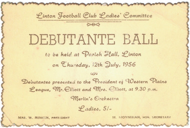
Card - Ticket, Linton Football Club Ladies' Committee Debutante Ball, 1956
Gold-edged yellow ticket with gold lettering, ticket for a debutante ball to be held in the Parish Hall, Linton on Thursday 12th July, 1956. Debutantes to be presented to the President of the Western Plains League, Mr. Elliott, and to Mrs. Elliott. Text: ' Linton Football Club Ladies' Committee / DEBUTANTE BALL / to be held at Parish Hall, Linton / on Thursday, 12th July, 1956 / Debutantes presented to the President of Western Plains / League, Mr. Elliott and Mrs. Elliott, at 9.30 p.m. / Merlin's Orchestra / MRS. W. RINGIN, PRESIDENT M. MOYNIHAN, HON. SECRETARY. ' linton football club ladies' committee, sports, social gatherings, debutante balls, debutantes, mrs. w. ringin, m. moynihan