Showing 296 items matching "park west road"
-
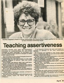 Park Orchards Community House
Newspaper, Assertiveness classes at Park Orchards Community House with tutor Sharne West. April 1987
-
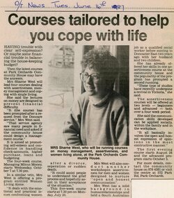 Park Orchards Community House
Newspaper, Financial and management classes at Park Orchards Community House, with instructor Sharne West. Doncaster and Templestowe News 16 June 1987
-
 Wonga Park Community Cottage History Group
Minutes, Wonga Park & District Residents' Association Joint West Riding Residents' Association Meeting Minutes 18 February 1981
-
Wonga Park Community Cottage History Group
Minutes, Wonga Park & District Residents' Association Joint West Riding Residents' Association Meeting Minutes 17 June 1981
-
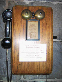 Parks Victoria - Cape Nelson Lightstation
Functional object - Telephones
Each of the five telephones is attached to a timber, wall‐mounted box. They are original to the precinct buildings and date from the early twentieth century. Located in the lighthouse lantern room, the former head keeper’s quarters, the former assistants’ quarters, and the buildings known today as the generator shed and the café, they formed an intercom system that facilitated communication between the lightstation buildings.Wall‐mounted Bakelite telephones with crank handles can be found at all six light stations, however Gabo Island has the only other example of a timber‐mounted phone. Its design is slightly different for incorporating an inclined surface for jotting down notes. As fixtures, the telephones are considered to be part of the building fabric and included in the Victorian Heritage Register listing for the Cape Nelson Lightstation (H1773; 18 February 1999). They are historically significant for their historical and technical values as part of the early communications system used at the lightstation.Five similar intercom system telephones. All are wall mounted timber boxes with Bakelite black hand sets and black cords. The five phones each have two bells at the top of the box and a crank handle at the side. Three phones have brass bells, two have black metal bells. All phones have instructions on the front either in a frame or glued to the timber."C of A" and "PMG" Written instructions on how to use the phones are printed on paper fixed to the front of the telephones. "TO CALL ....../ TO ANSWER...../ WHEN FINISHED....." -
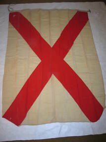 Parks Victoria - Cape Nelson Lightstation
Functional object - Flag set, navigational
The flags were used for communicating messages to passing ships. Knowledge of visual signaling was mandatory for all lightkeepers and all stations maintained a set of these flags. Although used for centuries, visual flag signaling formally developed in the nineteenth century and was published internationally as a system in 1857. By the early twentieth century it had developed into an effective means of conveying all kinds of short range visual messages.The Cape Nelson Lightstation is architecturally and scientifically (technologically) important as the most intact complex of lightstation buildings in Victoria. The octagonal signal station is a unique feature which is all the more important for its complete set of signal flags’. Cape Nelson Lightstation’s complete set of 41 alphabetic and numeric visual signaling flags (including substitute and answering pennants) are made of bunting, a coarse fabric of worsted (open yarn wool) in various colour combinations, and some of the fabric is hand sewn and bears inscriptions. Attachments include handmade wooden toggles, brass clips and hemp rope. -
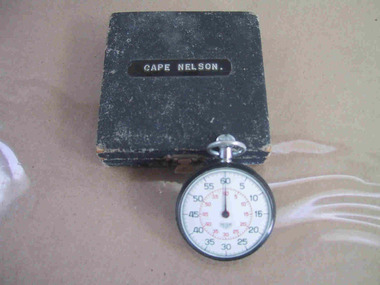 Parks Victoria - Cape Nelson Lightstation
Instrument - Watch, stop
The date of manufacture and age are unknown. It is believed to be original to the lightstation. Of six Victorian lightstation collections surveyed, Cape Nelson is the only one with a stop‐watch. The watch is significant as an intact and relatively uncommon object remaining at a Victorian lightstation and has first level contributory importance for its historical values.The circular, top‐winding metal stop‐watch has an associated blue velvet‐lined, square case. The watch bears an inscription but the date of manufacture and age are unknown. It is believed to be original to the lightstation. The watch bears an inscription etched into the back." C. of A. / C.L.S. /^ / No 101" and on a sticker "C of A / D.O.T. ....." -
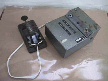 Parks Victoria - Cape Nelson Lightstation
Instrument - Morse Code Key Set
The battery powered set, which dates from the second half of the twentieth century, comprises two main components, the electronic keyer with a single lever for tapping, and a transmitter (?), both connected by a keying cable. Morse code was invented in the 1830s by American, Samuel Finely Breese by using electrical signals to quickly transmit information over a long range. In the early 1890s Italian inventor, Guglielmo Marconi improved the technology to the point where it became an essential device used for commercial and government purposes. The first practical applications were demonstrated with maritime messaging, where this simple mode of communication was seen as a timely replacement for the historic practice of signaling by flags, lights and foghorns. Cape Schanck has an earlier Morse code key, which is original to the lightstation (CSLS 0035), and Cape Otway has another early example although its provenance to the lightstation has not been formally verified (COLS 0074). The Morse code set has first level contributory significance for its historical value as an earlier communications device that has since been made redundant by more sophisticated technologies.Morse code key set. Comprised of the tapping component and a metal box part with a white electrical cord.Yes -
 Parks Victoria - Cape Nelson Lightstation
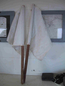
Functional object - Flags, semaphore
The two semaphore flags were used as a pair for visual signaling by hand. The semaphore system is an alphabet signaling system based on the waving of a pair of handheld flags in a particular pattern to compose words to be communicated to passing ships. The system was introduced by the Royal Navy in 1880 and was later adopted in Australia, with the first School of Signaling opening in Williamstown in 1890. The system was superseded in the 1970s by more sophisticated methods of communication. Information on the Cape Nelson flags indicates that they were made by Evan Evans P/L, Flag makers, 690 Elizabeth Street, Melbourne. Evan Evans (d.1927) started a tent‐making business in 1877 and by 1920 Evan Evans P/L maker of canvas goods, was located at 680 Elizabeth Street, Melbourne. In 1924 it acquired land at 632 Bourke Street and built a new factory. His son Ivor continued the business after 1927 and in 1938 opened a bulk store in Carlton.271 In 2016 the firm was located at 673 Spencer Street, Melbourne. Another pair of white semaphore flags made by Evan & Evans is held at Gabo Island, and Wilsons Promontory also has a pair. Cape Nelson’s white semaphore flags have second level contributory significance. They have historical importance as flags formerly used at the lightstation for visual signaling, a system that is now rarely used in navigation, and contribute to the importance of the lightstation’s large collection of flags.A pair of white flags made of white canvas/heavy cotton, the square flags are attached to dowel poles with staples. -
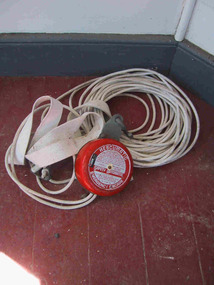 Parks Victoria - Cape Nelson Lightstation
Equipment - Rescue Harness
The ‘Resumatic’ brand, British made, lightweight device comprises a red pulley with attached length of white rope and harness. Information on the item indicates that it was the property of the Department of Transport, Australia. The Commonwealth Lighthouse Service was associated with the Department of Shipping and Transport in 1951 and the Navigational Aids Branch of the Department of Transport in 1972 so the harness may date to this period. The easily operated descent device was used for automatic, controlled descents from overhead structures, such as towers and other buildings and did not require a power source or tools. The user needed to make sure the unit is secured to an anchor point so that the cable could be dropped to the ground. As soon as it was secured the user could put on the support harness, step off the edge and travel down to safety. The device complements a number of other items of rescue equipment held in the wider Parks Victoria lightstation collection which attest to the dangers inherent in lightstation work and necessity for first aid kits, resuscitators, life buoys, life jackets and other devices such as harnesses and pulleys used for moving people. These include a bosun’s chair and harness with pulley, Royal Flying Doctor first aid cabinet, resuscitator kit and case, first aid kit, lifebuoy and cork fragments x 4 all in the Gabo Island collection; a rescue basket, resuscitation kit and case, and pulleys and ropes at Cape Otway; rescue stretcher made of bamboo at Wilsons Promontory; and a rescue anchor at Cape Schanck. The Cape Nelson rescue harness, although unique in the broader lightstation collection, is a relatively common device that is still manufactured more or less the same in England. It has second level contributory significance for offering insights into the various methods used in rescue operations by Victoria’s lightstations.Length of white rope attached to a harness and a red pully device.yes -
 Parks Victoria - Cape Nelson Lightstation
Instrument - Lamp, Aldis
This portable, hand held visual signaling lamp, with trigger mechanism and inner reflective disk, was used for optical communication via Morse code, with the concave mirror tilted to focus the light into pulse signals. Larger versions of these lamps are fixed on ships or pedestals and have shutters in front of the light that are opened and closed to transmit signals. Smaller hand held versions like the Cape Nelson example have a concave mirror that is tilted to focus the light into pulse signals, and despite their size the lamps were renowned for their brilliant light. Invented by Arthur C W Aldis (1878‐1953) and pioneered by the British navy in the late nineteenth century, they continue to be used to the present day. Details on the Cape Nelson lamp include a serial number, a date of 1960 and the initials of the Department of Transport, which at that time incorporated the Commonwealth Lighthouse Service. Another lamp of the same date which is held at Wilsons Promontory was provided to the lighthouse by the Department of Shipping for signaling ships but was also used for communicating with Cliffy Island, 18 nautical miles away. Point Hicks also has an Aldis lamp and an associated case, which is painted an army green colour. A fourth lamp and case formerly at Cape Schanck disappeared from the collection sometime between 1995 and 2003. These types of lamps are not rare in museum collections.These types of lamps are not rare in museum collections however the Cape Nelson example has a reliable provenance to the lightstation and has first level contributory significance as a fine example of the Aldis lamps that were distributed to lightstations throughout Victoria and Australia.This object is comprised of a black metal encased Aldis lamp with electrical cord and associated wooden carrying case with metal clasp and red leather hand grip. yes -
 Parks Victoria - Cape Nelson Lightstation
Furniture - Cabinet
The cabinet has a curved back and would have been custom‐built to fit the dimensions of the lantern room interior. It is likely to date from when the lighthouse was built in 1884 and may have been among the items delivered by the government steamer dispatch early in March which included ‘the lantern and other fittings for the Cape Nelson Lighthouse’. The Public Works Department provided a range of lightstation furnishings including office desks and cabinets, and domestic settings for keepers’ quarters, with nineteenth century items often stamped with a crown motif and the PWD monogram however the curved cupboards installed in Victoria’s lighthouse lantern rooms do not appear to display this small feature. Further research may reveal more about their manufacture and it is tempting to think that they were perhaps even supplied by Chance Bros as part of the entire lantern room installation. The company usually provided the timber battens for the lantern room paneling, and a cabinet may have been included in the assemblage. Another possibility is that the specially designed cabinet was made on site by carpenters along with other fittings. It is not known whether it is attached to the wall or movable; if attached it is considered to be a fixture and included in the Victorian Heritage Register listing for the lightstation (VHR H1773). Its location, when identified in the CMP of April 1995, was on the ‘lower lantern level’, where there was also a ‘timber step ladder’ (Argus, 6 March 1884, p6. nineteenth or early twentieth century), ‘timber framed lighthouse specification’, ‘timber framed chart’ and telephone .Residue on the furnishing indicates that it was formerly painted green, the colour of some of the other fixtures in the room, such as the original cast iron ladder. It is now partially varnished and the corner to the top’s edging on the right side has been cut off. The lighthouse also has a large curved back, two‐door cupboard. Other similar cabinets with curved backs survive at Cape Schanck, varnished wood cabinet with brass door knob, no drawers; Point Hicks, painted green with silver doors, no drawers and Gabo Island, bench top, 2‐door, no drawers, green paint removed to reveal cedar timber). Cape Nelson’s curved cabinet is unique among these examples for having drawers. The cabinet is a unique, original feature of the lantern room and has first level contributory significance for its historic values and provenance.The bench top cupboard has two drawers, each above a door, and each door is framed and beveled around a central panel. The cabinet has a curved back. -
 Parks Victoria - Cape Nelson Lightstation
Furniture - Cabinet
The tall, two‐door cupboard with curved shelves is without a back and is taller than the bench cupboard on the lower lantern room of the lighthouse . The curved shelving suggests that this practical storage cupboard was custom‐built or adapted to serve in this location on the landing level below the lantern room. It is not known when it was provided to the lightstation. It shares the structural features of this furnishing as well as other nineteenth century utilitarian cabinets that were made for Victoria’s lightstations, such as those fitted beside fireplaces in the keepers’ quarters (for example CNLS 0016) or serving as lantern room cupboards. They have doors simply framed and bevelled around central panels. This particular cupboard, which is painted grey with four white panels, is unusual both for its height and the four doors, with the twin top panels taller than those underneath. This panel arrangement repeats the design of the lightstation’s door cases. Further research may reveal more about its manufacture. It is not known whether it is attached to the wall or movable; if attached it is considered to be a fixture and included in the Victorian Heritage Register listing for the lightstation (VHR H1773). Other similar cabinets which have been constructed to fit the curved wall of a lighthouse survive at Cape Schanck, varnished wood benchtop, 2‐door cabinet with brass door knob, no drawers); Point Hicks, benchtop, 2‐door, painted green with silver doors, no drawers) and Gabo Island bench top, 2‐door, no drawers, green paint removed to reveal cedar timber), and Cape Nelson, benchtop, 2‐door, 2‐drawer, partially varnished). Cape Nelson’s tall cupboard with curved shelves and back profile is unusual among the lighthouse furnishings. The cabinet is a unique, original feature of the lighthouse and has first level contributory significance for its historic values and provenance.The tall, two‐door cupboard with curved shelves is without a back and has curved shelving. Painted grey with four white panels, on the four doors, with the twin top panels taller than those underneath. -
 Parks Victoria - Cape Nelson Lightstation
Furniture - Cabinet
The two‐door cabinet with a bench top is a simply made nineteenth century utilitarian cupboard. It is similar in style to cupboards that were built into spaces either side of fireplaces in keepers’ quarters. All have two doors simply framed around recessed central panels, which are sometimes bevelled. They are opened with a key, or by a basic knob made of metal or turned wood. Most also are made from a light‐coloured wood, which in this case is possibly Huon pine. Some are painted, others show evidence of paint which has since been removed in an effort to restore the surface, and a few retain their original wood finish. This cabinet, which has plain recessed unbevelled panels, has one internal shelf and stands on the floor without a plinth base. The bench top has basic squared edges, and a low backing with curved ends extends around one side. These features suggest the cabinet was fixed and originally built into a corner. The Cape Nelson CMP identified a similar but slightly different cabinet in one of the assistant keepers’ quarters which is shown with shelves added to the top. Other similar two‐door, benchtop cupboards that were probably built‐in include those at Cape Otway and Cape Schanck , which have since been moved out of the residences. Built‐in cabinets were standard fittings in lightkeeper quarters as illustrated by the Point Hicks Lightstation CMP, which shows a built cupboard beside a fireplace. The Cape Nelson cabinet, an original domestic furnishing provided by the Public Works Department, has first level contributory significance for its historic values and provenance to the lightstation.Two‐door cabinet with a bench top. The doors are simply framed around recessed central panels.Light coloured wood. -
 Parks Victoria - Cape Nelson Lightstation
Furniture - Chair, Douglas
The chair’s turned legs and bowed, spindle back are typical characteristics of the popular ‘Douglas’ chair, which descends from the long evolutionary line of ‘Windsor’ style cottage chairs. Also known as ‘Captains’ chairs, they were made on a large scale in England, America and Australia from around the 1860s in various timbers, with seats ranging from heavy pine to cane and in later models, plywood. Australiana expert, Peter Cuffley writes that they were just as much a part of Australia’s frontier experience as they were America’s; Holtermans’ 1872 photographs of the New South Wales gold towns show Douglas chairs, and they appear in illustrations of the exploits of the Kelly gang drawn in the late 1870s. Many Australians now are more likely to associate them with public offices and governments departments’. The chairs met the need for a degree of comfort and tough resilience under rough handling on hard floors. The Cape Nelson chair is known to have been used as a visitor’s chair, presumably in the head keeper’s office. No other examples of nineteenth century style chairs survive among the reliably provenanced furnishings in the five other lightstation collections. The chair complements the lightstation’s nineteenth century office desk and small number of other nineteenth century furnishings in the wider Parks Victoria lightstation collection, the majority of which are domestic items. The Douglas chair has first level contributory significance for its historical value and relative rarity as a lightstation office furnishing.The chair has turned legs and bowed, spindle back . -
 Parks Victoria - Cape Nelson Lightstation
Furniture - Sideboard
The cedar sideboard has two cupboard doors below two corresponding drawers. The style is in keeping with the completion date of the lightstation in 1884, when furniture in the late nineteenth century had squarer, more defined lines and angles, and ornamental features. This sideboard is a modest version of this trend combining a pediment‐shaped back board with turned side columns and finials, rectangular mirror, decorative drawer pulls and door handle, as well as cupboards and drawers with bevelled, raised panels. The initials ‘PWD’along with a crown motif and letters are inscribed on the side indicating that the furnishing was the property of the government and made in its workshops. The Public Works Department, which operated in Victoria from 1855 to 1987, was responsible for the design of Victoria’s major public buildings and provision of furnishings to its offices as well as residences where the need was required.301 The keepers’ quarters at Cape Otway Lightstation were supplied with two of the same sideboards, which remain there today; on is intact (COLS 0001), the other missing the backboard (COLS 0015). Two similar but plainer examples, which are probably earlier in date, also remain at Cape Schanck (CSLS 0007.3; CSLS 0009.3). The Cape Nelson sideboard has first level contributory significance as a fine example of the good quality domestic furnishings made by the Victorian Government and provided to lighthouse keepers and their families in the late nineteenth century. It is also significant for its provenance to the lightstationThe cedar sideboard has two cupboard doors below two corresponding drawers with pediments‐shaped back board with turned side columns and finials, a rectangular mirror, decorative drawer pulls and door handle, as well as cupboards and drawers with bevelled, raised panels. -
 Parks Victoria - Cape Nelson Lightstation
Furniture - Bookcase
Their polished wood finish appears to be original to their date of manufacture during the 1960s‐70s. They were located in the head keeper’s and assistant keepers’ quarters, where their use for office purposes also may have crossed over to a domestic function. In the post‐war years the Commonwealth Lighthouse Service (CLS) introduced modern, low‐cost furnishings to lightstations. Most notably, it commissioned a number of light, compact and functional items in bulk from émigré designer, Steven Kalmar (1909‐ 1989), who played a significant role in popularising modernist design concepts in Australia and drew his ideas from Scandinavian and American design trends. Born in Hungary, he trained as an architect and his contemporary affordable furnishings were especially suitable for the open‐plan houses being built in Australia’s new post‐war suburbs. It is not known whether the bookcases bear the Kalmar label, but the design, particularly the legs and bar bracing, is a signature style that is associated with his Sydney‐based firm, Kalmar Interiors. The CLS supplied the same bookshelves to a number of other lightstations, including Point Hicks, Cape Otway and Gabo Island, as well as other types of furnishings such as tables and cabinets. The bookcases have first level contributory significance as examples of the modernist furnishings that the Sydney‐based firm, Kalmar Interiors supplied to the Commonwealth Lighthouse Service in the post‐war years.The bookcases stand at about bench level and are almost square in dimension. They have two adjustable shelves as well as the base shelf and stand on legs supported by a single stretcher with a polished wood finish. -
 Parks Victoria - Cape Nelson Lightstation
Furniture - Desk
The desk was used by the head keeper and supplied by the Public Works Department, and possibly dates to when the lightstation commenced operations in 1884. Closer inspection of the wood may reveal the Crown motif and PWD monogram on the side or underpart of the furnishing. The PWD operated in Victoria from 1855 to 1987 and was responsible for the design of Victoria’s major public buildings and infrastructure as well as the supply of stores, furniture and equipment. The desk is identical to the large example remaining at Point Hicks. A smaller version, which is at Cape Schanck, has two sides stamped with the crown motif and PWD monogram. Another of the smaller desks formerly at Cape Schanck is now missing. Gabo Island has a small cedar desk or table in the same style, but with one drawer. There are also c.mid‐twentieth century desks remaining in the collections at Wilsons Promontory and Gabo Island. The Cape Nelson desk has first level contributory significance for its provenance and historical value as a government issued furnishing that is original to lightstation’s head keeper’s office.The large, late nineteenth century cedar desk has two drawers, leather inset top and sturdy turned legs. The drawers each have a pair of wooden knob pulls. -
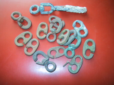 Parks Victoria - Cape Nelson Lightstation
Equipment - Flag clips
The items include one intact brass clip and sections of others. They were used for hoisting visual signalling flags and relate to the use of the forty‐one flags (CNLS 0004.41), which were used to convey messages to passing ships and which are included in the Victorian Heritage Register listing for the lightstation (VHR H1773) . They have second level contributory significance for their provenance to the lightstation and association with its set of navigational flags (CNLS 0004.41), which were a major part of the communications system formerly used at the lightstation.Twenty one flag clips, some are intact others partial. One intact brass clip. -
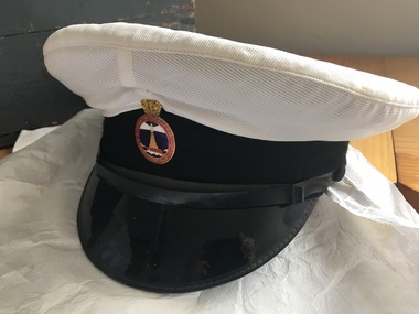 Parks Victoria - Cape Nelson Lightstation
Uniform - Hat
-
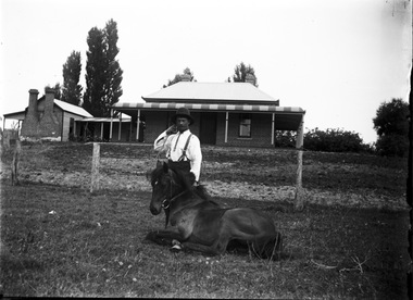 Wodonga & District Historical Society Inc
Negative - Haeusler Glass Negatives Collection - Jack Parker and the pony he taught to do tricks
The Wodonga Historical Society Haeusler Collection provides invaluable insight into life in late nineteenth and early twentieth century north east Victoria. The collection comprises manuscripts, personal artefacts used by the Haeusler family on their farm in Wodonga, and a set of glass negatives which offer a unique visual snapshot of the domestic and social lives of the Haeusler family and local Wodonga community. The Haeusler family migrated from Prussia (Germany) to South Australia in the 1840s and 1850s, before purchasing 100 acres of Crown Land made available under the Victorian Lands Act 1862 (also known as ‘Duffy’s Land Act’) in 1866 in what is now Wodonga West. The Haeusler family were one of several German families to migrate from South Australia to Wodonga in the 1860s. This digital image was produced from one of the glass negatives that form part of the collection, probably taken by Louis Haeusler (b.1887) with the photographic equipment in the Wodonga Historical Society Haeusler Collection. Parker Family - Samuel Skelton Parker, Jack Parker’s father, migrated to Australia from Ballymena, Country Antrim, Ireland in 1884. He married Bridget Cusack from County Clare in 1883. They had children William, James, Jack, Samuel and Rachel. After working on a station in northern NSW, they moved to Barnawartha and set up a butchery and later a bakery. In 1890 the family moved to Wodonga, buying a property in West Wodonga, which he called “Park Hall” after his home in Ireland. The property is now the location of the Wodonga Golf Club in Parkers Road, West Wodonga.This item is unique and has well documented provenance and a known owner. It forms part of a significant and representative historical collection which reflects the local history of Wodonga. It contributes to our understanding of domestic and family life in early twentieth century Wodonga, as well as providing interpretative capacity for themes including local history and social history.Digital image created from the Haeusler Glass negative collection. Jack Parker and his pony in the centre front of the image. Jack taught this pony to perform several tricks. The Parker family home and some outbuildings are visible in the background. This is a substantial brick house with corrugated iron roof.wodonga pioneers, haeusler family, glass negatives, dry plate photography, parker family wodonga -
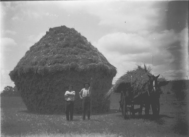 Wodonga & District Historical Society Inc
Negative - Haeusler Glass Negatives Collection - Two men in front of a haystack, Parker's Farm, Wodonga West
The Wodonga Historical Society Haeusler Collection provides invaluable insight into life in late nineteenth and early twentieth century north east Victoria. The collection comprises manuscripts, personal artefacts used by the Haeusler family on their farm in Wodonga, and a set of glass negatives which offer a unique visual snapshot of the domestic and social lives of the Haeusler family and local Wodonga community. This digital image was produced from one of the glass negatives that form part of the collection, probably taken by Louis Haeusler (b.1887) with the photographic equipment in the Wodonga Historical Society Haeusler Collection. Parker Family - Samuel Skelton Parker, Jack Parker’s father, migrated to Australia from Ballymena, Country Antrim, Ireland in 1884. He married Bridget Cusack from County Clare in 1883. They had children William, James, Jack, Samuel and Rachel. After working on a station in northern NSW, they moved to Barnawartha and set up a butchery and later a bakery. In 1890 the family moved to Wodonga, buying a property in West Wodonga, which he called “Park Hall” after his home in Ireland. The property is now the location of the Wodonga Golf Club in Parkers Road, West Wodonga.This item is unique and has well documented provenance and a known owner. It forms part of a significant and representative historical collection which reflects the local history of Wodonga. It contributes to our understanding of domestic and family life in early twentieth century Wodonga, as well as providing interpretative capacity for themes including local history and social history.Digital image created from the Haeusler Glass negative collection. Two men in front of a haystack, working on the Parker family farm in Wodonga West. C. 1910wodonga pioneers, haeusler family, glass negatives, dry plate photography, parkers wodonga -
 Wodonga & District Historical Society Inc
Negative - Haeusler Glass Negatives Collection - Jack Parker with the pony he taught to do tricks
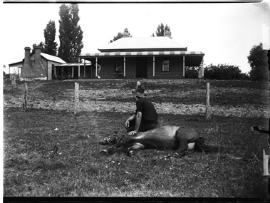
The Wodonga Historical Society Haeusler Collection provides invaluable insight into life in late nineteenth and early twentieth century north east Victoria. The collection comprises manuscripts, personal artefacts used by the Haeusler family on their farm in Wodonga, and a set of glass negatives which offer a unique visual snapshot of the domestic and social lives of the Haeusler family and local Wodonga community. The Haeusler family migrated from Prussia (Germany) to South Australia in the 1840s and 1850s, before purchasing 100 acres of Crown Land made available under the Victorian Lands Act 1862 (also known as ‘Duffy’s Land Act’) in 1866 in what is now Wodonga West. The Haeusler family were one of several German families to migrate from South Australia to Wodonga in the 1860s. This digital image was produced from one of the glass negatives that form part of the collection, probably taken by Louis Haeusler (b.1887) with the photographic equipment in the Wodonga Historical Society Haeusler Collection. Parker Family - Samuel Skelton Parker, Jack Parker’s father, migrated to Australia from Ballymena, Country Antrim, Ireland in 1884. He married Bridget Cusack from County Clare in 1883. They had children William, James, Jack, Samuel and Rachel. After working on a station in northern NSW, they moved to Barnawartha and set up a butchery and later a bakery. In 1890 the family moved to Wodonga, buying a property in West Wodonga, which he called “Park Hall” after his home in Ireland. The property is now the location of the Wodonga Golf Club in Parkers Road, West Wodonga.This item is unique and has well documented provenance and a known owner. It forms part of a significant and representative historical collection which reflects the local history of Wodonga. It contributes to our understanding of domestic and family life in early twentieth century Wodonga, as well as providing interpretative capacity for themes including local history and social history.Digital image created from the Haeusler Glass negative collection. Jack Parker sitting on his pony which is lying down on the ground. Jack taught this pony to perform several tricks. The Parker family home and some outbuildings are visible in the background. This is a substantial brick house with corrugated iron roof.wodonga pioneers, haeusler family, glass negatives, dry plate photography, parker family wodonga, horsemanship -
 Wodonga & District Historical Society Inc
Negative - Haeusler Glass Negatives Collection - Sam Parker's Farm c1910
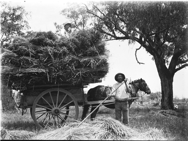
The Wodonga Historical Society Haeusler Collection provides invaluable insight into life in late nineteenth and early twentieth century north east Victoria. The collection comprises manuscripts, personal artefacts used by the Haeusler family on their farm in Wodonga, and a set of glass negatives which offer a unique visual snapshot of the domestic and social lives of the Haeusler family and local Wodonga community. The Haeusler family migrated from Prussia (Germany) to South Australia in the 1840s and 1850s, before purchasing 100 acres of Crown Land made available under the Victorian Lands Act 1862 (also known as ‘Duffy’s Land Act’) in 1866 in what is now Wodonga West. The Haeusler family were one of several German families to migrate from South Australia to Wodonga in the 1860s. This digital image was produced from one of the glass negatives that form part of the collection, probably taken by Louis Haeusler (b.1887) with the photographic equipment in the Wodonga Historical Society Haeusler Collection. Parker Family - Samuel Skelton Parker, Jack Parker’s father, migrated to Australia from Ballymena, Country Antrim, Ireland in 1884. He married Bridget Cusack from County Clare in 1883. They had children William, James, Jack, Samuel and Rachel. After working on a station in northern NSW, they moved to Barnawartha and set up a butchery and later a bakery. In 1890 the family moved to Wodonga, buying a property in West Wodonga, which he called “Park Hall” after his home in Ireland. The property is now the location of the Wodonga Golf Club in Parkers Road, West Wodonga.This item is unique and has well documented provenance and a known owner. It forms part of a significant and representative historical collection which reflects the local history of Wodonga. It contributes to our understanding of domestic and family life in early twentieth century Wodonga, as well as providing interpretative capacity for themes including local history and social history.Digital image created from the Haeusler Glass negative collection. A man spreading hay with a rake in the foreground. A horse and cart loaded with hay is behind him.wodonga pioneers, haeusler family, glass negatives, dry plate photography, wodonga families, early farming -
 City of Kingston
Photograph - Black and white, c. 1956
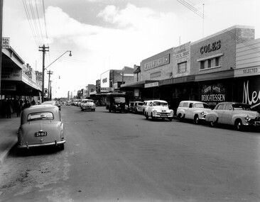
Black and white photograph depicting Centre Road Bentleigh, looking west. On the right hand side of the road there are two Coles stores. The one in the background is the newly opened store while the one in the foreground has been repurposed and is now a delicatessen. There are numerous cars parked on both sides of the road, including one that appears to be "double parked" on the right hand side of the road.Black and white photograph depicting Centre Road Bentleigh, looking west. On the right hand side of the road there are two Coles stores. The one in the background is the newly opened store while the one in the foreground has been repurposed and is now a delicatessen. There are numerous cars parked on both sides of the road, including one that appears to be "double parked" on the right hand side of the road.Handwritten in blue ink on a white sticker adhered to the reverse of the photograph: COLES BENTLEIGH c. 1956 / Centre Road looking west / The Old Coles store is in the foreground / and the new Coles is in the background.bentleigh, suburbs, shopping strip, cars -
 Lakes Entrance Historical Society
Postcard - Lakes Entrance, 1940c
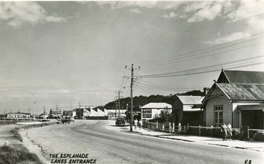
From a wallet of miniature postcards produced by H D Bulmer for sale to touristsBlack and white small format post card of Esplanade, looking west. Buildings identified are the Club Hotel, Mitcheleson's Fancy Goods, Coate Bros Garage (later Crawford's), Broomes Auto Park, John's Milk Bar, Methodist Manse. Lakes Entrance VictoriaThe Esplanade Lakes Entrancetownship, roads and streets, retail trade -
 Melbourne Tram Museum
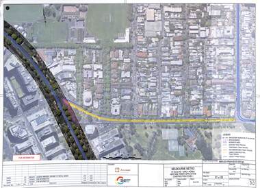
Drawing - Set of 5, Melbourne Metrorail, "Melbourne Metro St Kilda Road - early works", 10/2016
Drawings prepared by the Melbourne Metro project to show the relocation of Domain Interchange, Domain Road and Park St South Yarra to Toorak Road West and St Kilda Road. Drawings prepared for a Heritage Victoria application dated 26/10/2016. Shows the various work stages principally at the site of Domain Junction where the tram tracks had to be relocated to facilitate the construction of Anzac station.Yields information about the relocation of Domain Interchange to facilitate the construction of the Melbourne Metro.Set of five laminated A3 colour prints with a punch hole in the top left hand corner.metro tunnel, domain interchange, domain road, toorak road, st kilda road, heritage victoria, anzac station -
 Charlton Golden Grains Museum Inc
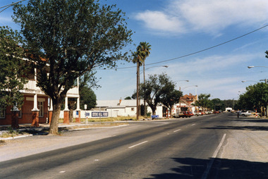
Photograph, High St Charlton, east end, southside c. 1987, c.1987
Cricket Club Hotel established 1875, rebuilt as a two storey building 1935. Photograph part of the Shire of Charlton streetscape 1987Colour photograph looking west along High St. Cricket Club Hotel on the other side of the road with a large tree in front of the building. Blue and white signage for Steve Hill Ford further along with two palm trees at the front. Cars parked along both sides of the street. A person riding a bike toward the photographer.cricket club hotel, high st charlton, charlton, business, industry -
 Charlton Golden Grains Museum Inc
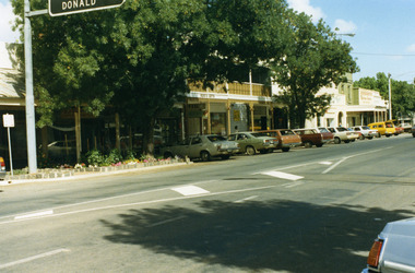
Photograph, Pollard, Jenny, High Street Charlton 1989, c.1989
Shops at west end and south-side of High Street. Tippett's Clothing & Furniture shop (established 1923), Ross's Gifts (in former Procter's Butcher shop built 1880), Paterson's Fibre Glass Factory, Eddie Harris Mensland.Colour photograph of the shops at west end and south-side of High Street. 'Donald' on road sign in top left of photo. Large tree in garden bed in front of shops. Sign on shop "Ross's Gifts'. Cars parked all along the street.tippett, ross's gifts, procter, paterson's fibre glass, business, industry, charlton -
 Lakes Entrance Historical Society
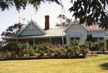
Photograph - Nyerimilang, 1999
Nyerimilang Homestead is in public ownership, managed by Parks Victoria.Colour photograph of Nyerimilang Homestead showing front view, including rose garden. Situated off Kalimna West Road, Nungurner, it is a large white painted timber homestead, corrugated iron roof of hips and gables, painted green, five internal brick chimneys. Situated above the lake with views of Fraser Island and Flannagan Island, outer barrier and distant ocean. Nungurner Victoriahistoric buildings, local history